

wxdude64
-
Posts
7,622 -
Joined
-
Last visited
Content Type
Profiles
Blogs
Forums
American Weather
Media Demo
Store
Gallery
Everything posted by wxdude64
-
Takes that back, snow has picked up and on radar a decent batch to my west to push thru, I'll wait a bit. WAS gonna measre and send in a snow event total to NWS Blacksburg, maybe later. Eyeballing where I've cleared earlier guesstimate 1.5 has fallen since 7 am.
-
Had chicken and taters for dinner last night, so that determined this morning's late lunch/brunch. Tater cakes, bacon and toast with homemade blackberry jam. Or, as I refer to it when I make it, the biege/tan meal. Oh, this is not banter, lol. Looks like snow has lightened up a good bit in last 15, we may be done here. Still below freezing at 29.0/27.9.
-
I was kidding but appears I'm right....sadly.
-
0.3?
-
*First day in school for the little one in the future* Teacher- "So, again, explain your name 'Reekbok Snowtread' once again??"
-
Wishing you and family the best! You'll have to pick a 'snowy' type name for the baby!
-
You could have left the 'Dusting of snow' part out and still be correct.
-
Yes it is! When I did CoCoRaHS this morning at 7 am I had 3.8" on 0.36" liquid, about 10.6 to 1 ratio.
-
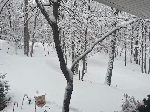
Pic from front porch about 30 minutes ago.
-
11/11 0.1 11/30 0.1 12/02 0.2 (sleet) 12/05 3.8 Total 4.2
-
Forgot the most important part, measured 4.5" when I got back.
-
Just in from a short Jebwalk, beautiful out there! Snow has stuck to everything. Still a light snow falling at 8 am.
-
3.8 inches on the snowboard at 7 this morning. Still snowing, 28.7/27.6.
-
Off to get a nap, will report back later.
-
Looked close, and JUST right at an inch at 12:45. That is 90 minutes to make an inch. Currently 29.9/27.5 with snow falling.
-
Cutting wood at midnight???
-
Richmond Metro/Hampton Roads Area Discussion
wxdude64 replied to RIC Airport's topic in Mid Atlantic
Brings back great memories when son was home and learning to snowboard. -
About the same here. Nice almost quarter sized flakes. 31.5/27.0.
-
And went from small pixie type flakes to dime and nickel sized ones within minutes.
-
And I have flakes falling from the sky now, 32.2/26.5.
-
Snow just started in Roanoke.
-
Looking at traffic cams, snowing in Blacksburg and Beckley WV, draw a line between the two for forward progress of the snow. Currently 32.0.26.7 here and waiting.
-
Well, forecast was updated about 20 minutes ago, right there on the edge of WSW criteria -
-
Bumped up again, now 65% chance at 4", a 38% chance at 6" and a 10% chance at 8". NWS bumped forecast to 3-6 total.
-
Appears River/bay enhanced?? Would a model pick up something like that?


