J.Spin
-
Posts
6,282 -
Joined
-
Last visited
Content Type
Profiles
Blogs
Forums
American Weather
Media Demo
Store
Gallery
Everything posted by J.Spin
-
I told my wife about how good the skiing was yesterday, so she was interested in getting out and the two of us headed up to Bolton Valley today for another tour. Thanks to the ongoing lake-effect snow from Lake Ontario, surfaces have been getting some nice refreshers. Since my report detailing the snow during yesterday’s tour, we’ve had another inch or two of additional snow down at the house in the valley, so I’m sure Bolton has had at least that much as well. It was really dumping when I left yesterday afternoon, so that period alone should have contributed some nice accumulations. Between settling and the additional snow that’s been falling, snow depths seemed to be just about where they were yesterday, so just refer to the detailed snow depth profile I posted in that post for approximate snow depths that were out there today. Temperatures were in the mid-20s F out on the mountain early this afternoon, so it was just a bit cooler than yesterday, and consistent with that, the snow was a bit drier. Whereas yesterday I estimated the upper layers of powder in the snowpack to be in the 8% H2O range, today I’d say we were hitting powder that was more in the 6 to 8% H2O range. My wife is notorious for getting out on the snow one day too late when conditions aren’t as good as the day before, but that wasn’t the case this time. While there were a few more tracks out there today than what I found yesterday, the dry air and drier snow falling kicked the quality of the powder up a notch. The existing base snow, the continued settling of the lower layers of surface snow, and new rounds of dry snow coming in have set up some beautiful right-side-up powder. The drier nature of the powder was evident in the way it was even easier to ski lower-angle slopes; I’d brought fat skis to help in that regard, but my wife was on mid-fats, and she had no issues maintaining speed on even the mellowest pitches. So once again, essentially any mowed terrain from roughly single black diamond pitch down to gentle slopes was in play for great powder turns today. In terms of the ongoing snowfall, today was much like yesterday with continued light snowfall of varying intensity throughout our tour, and it was steadier when we were finishing up our descent, but not nearly as heavy as when I was leaving yesterday. The direction of the more intense incoming moisture from Lake Ontario seemed to be a bit more to our north today, but it sounds like the Jay Peak area has been doing well from that setup.
-
With the Thanksgiving winter storm wrapping up overnight, today was clearly a day to get out for some skiing, but I wasn’t initially sure where I was going to go. The storm seemed to be more potent further south based on observations that I’d seen, as well as images from mountain cameras like the Okemo snow stake webcam and the Sugarbush snow stake webcam – they both showed about a foot of new snow at elevation. We’d been watching Bolton Valley’s webcams throughout the storm, and the resort was certainly getting some decent accumulations, but Bolton doesn’t have a specific snow stake webcam and it was a bit difficult to get a feel for just how much they’d received from the wider views. This morning, I perused a variety of mountain webcams from around the state, and in the end, there didn’t seem to be all that much difference in practical base area accumulations and coverage between what I was seeing at Bolton and the various resorts father south. I also checked on how much liquid equivalent was in the new snow, since that has such a big impact the quality of the skiing, and while the Vermont CoCoRaHS numbers seemed to be around 1.00 inches of liquid to our south, we’d picked up over 0.6 inches of liquid in the snow that fell at our house in the valley, so I’d expect Bolton Valley to have picked up at least that much. With some base snow already in place at Bolton, that felt like plenty of snow for some good touring and turns. Overall, the decision ended up being relatively easy, and I headed up to Bolton around midday. Down at the base of the Bolton Valley Access Road at 340’, new snow accumulations were just spotty, with areas of grass visible, but by the time I hit the Village at 2,000’, I found 6 to 8 inches of fresh snow, so the skiing prospects were looking good. I ascended by the Wilderness Uphill Route, and the skin track was nicely set. I probed snow depths throughout the tour, and by the time I hit the Wilderness Summit at roughly 3,150’, depths were in the 12 to 14-inch range. Above 2,000’ there was already existing snowpack in place, so the higher-elevation snow depths I measured on today’s tour weren’t necessarily all from this most recent storm, but here’s the detailed snow depth profile from today: 340’: T-1: 500’: 1” 1,000’: 2” 1,200’: 2-3” 1,500’: 3” 2,000’: 6-8” 2,250’: 8-10” 2,500’: 10-12” 2,750’: 11-13” 3,000’: 12-14” Although the precipitation from this storm was 100% snow even at our site at 500’ in the valley, temperatures were around freezing down low, so the accumulations were quite dense. That wasn’t the case up on the mountain though – the snow was considerable drier, and the powder was of good quality. It was clearly sub-10% H2O powder, and if I had to guess it was probably in the 8% H2O range above 2,000’. I’d brough mid-fat skis today since I was initially unsure of how deep the powder was going to be and how good the overall coverage would be, but one could easily go with fatter skis if they wanted. With some existing dense base snow in place, even black diamond terrain was easily in play today. You’ll still want to be on mowed, on-trail terrain though – I suspect that venturing onto anything with too many obstacles would find you hitting things below the base. And the trees are still not ready yet – the base isn’t deep enough to cover the typical obstacles in the woods. Today’s powder turns were great though, and the snow was dry enough that even low-angle terrain was fun. Fat skis could help there for a bit more planing and speed if you’re on the fence about what width to shoot for. Thanks to our upwind friend Lake Ontario, snow was falling the entire time I was out touring. For most of the tour the snowfall was of varying light intensity depending on whether a larger pulse of lake moisture was hitting the spine or not, but it jumped up to borderline heavy snowfall when I was leaving a bit before 2:00 P.M. There was a good shot of moisture hitting the mountain at that point and the top half of the Bolton Valley Access Road had taken on enough accumulation that people were really taking their time on the descent. With the lake effect snow event taking place right now, we’ve had about another inch of new snow down here in the valley, so I suspect they’ve had at least another couple of inches up at the resort. And there’s more moisture pushing into the area this evening based on the radar, so there should be some additional freshening of the powder surfaces for tomorrow.
-
#1 on that list of potential upcoming events finished up overnight, so we’re moving on to #2, and that should be the activity to watch over the next few/several days. It looks like that event is starting to move into the area – precipitation was just some flurries here this morning at observations time, but the snowfall is starting to pick up a bit and the radar shows some moisture moving toward the Greens.
-
This is probably the only thread that gets much discussion about the weather nuances in the Northern Greens, so I hadn’t even heard mention of much in terms of a bread and butter pattern, but I scrolled through the past couple of runs of the GFS, and it does have that look. The past couple of runs show the following parade of systems: 1) Nov 28-29: System passing through SNE 2) Nov 29-Dec 4: LES 3) Dec 5-6: Clipper 4) Dec 6-7: Clipper 5) Dec 9: Clipper/Coastal System 6) Dec 11-12: Coastal System 7) Dec 13-14: LES There aren’t too many days in there without snow. Of course, those later events from a deterministic model are subject to plenty of change, but the general idea is there. A vertically-stacked low pressure system sitting over Northern Maine or the Canadian Maritimes is certainly a favorite setup around here, but those don’t happen every day, and they don’t often sit for too long. Having that closed upper low over Hudson Bay with broad upper level troughing is also a great setup when you have a 4,000’ wall of mountains sitting downwind of a moisture source like the Great Lakes. The BTV NWS is talking about it in their short-term discussion: Area Forecast Discussion National Weather Service Burlington VT 852 AM EST Thu Nov 28, 2024 SHORT TERM /FRIDAY NIGHT THROUGH SATURDAY/... As of 419 AM EST Thursday...The closed upper low over the southern part of the Hudson Bay along with broad upper troughing across the Eastern US will be our main weather driver in the short term and beyond. West-southwesterly flow will continue to bring a lake effect snow band over `Dacks and the northern Greens, with the southeastern parts St. Lawrence County seeing a snow band persisting throughout Saturday and even into Sunday. You never know quite what we’ll get over here in the Northern Greens out of the potential LES setups, since the wind direction is critical and you have to have enough moisture to carry the distance, but it never hurts to have Mother Nature spraying plentiful moisture in the general direction of your local orographic wall. And the temperatures of the lakes are apparently nice and warm, so that’s good. The long-term discussion continues with mentions of some of the potential winter events in the queue: LONG TERM /SATURDAY NIGHT THROUGH WEDNESDAY/... As of 419 AM EST Thursday...Lake effect snow will continue into Sunday before the Lake Ontario band slides south of the CWA as the flow shifts to the northwest as the broad troughing finally moves eastward. With the northwesterly flow, snow showers in the high terrains will continue through the first half of the week. Global models show an upper trough sliding out of Central Canada and into our region late Wednesday and into Thursday which looks to be our next impactful round of snow. Temperatures will be unseasonably cold as daytime highs will be in the 20s and low 30s with overnight lows in the teens to low 20s for the long term. As I’ve mentioned before, I find the GFS seems to represent these bread and butter patterns well with respect to the Northern Greens – it just seems more cognizant of the terrain presence/influences than the other global/medium-range models for whatever reason. One doesn’t need to dig too much into it, just pop open the GFS, run through the panels, and you have a good idea of when some of the best days will be with respect fresh snow so that you can plan ahead with respect to your ski schedule.

-
Ahh, I see you posted the projected accumulations map as well when I was putting my post together - I wasn't sure if anyone else would be updating on the storm because it seemed sort of dead aside from the occasional post.
-
I was surprised when early this afternoon we were put under a Winter Storm Warning, especially since we were never even under a Winter Storm Watch or Winter Weather Advisory in association with this upcoming Thanksgiving system, but apparently the more northerly trends in the modeling came on rather quickly. The latest BTV NWS maps are below.
-
This morning, I received a text alert that we’d been put under a Winter Weather Advisory. It was initially surprising and seemed a bit early for anything that might happen later in the week, but it’s been posted to cover the potential freezing precipitation that could occur with the system coming into the area tomorrow. I believe this is the first Winter Weather Advisory of the season for our county area, with the intent to keep people apprised of the potential travel issues tomorrow morning.
-
Snow levels definitely came down overnight in the Northern Greens as was suggested in the BTV NWS forecast discussion text I’d pasted in above. Checking the Bolton Valley webcams – there’s accumulating snow at the 3,150’ Vista Summit webcam, and it’s even snowing down to the main base at 2,100’ as seen on the 2,100’ main base webcam, although it’s not yet accumulating there. Snow levels will probably go up and down a bit in the coming days, but now that the mountain temperatures are down, the forecasts don’t show any substantial rises for a while, so they should just keep accumulating snow (or maybe frozen/mix depending on how that potential Tuesday system tracks). Area Forecast Discussion National Weather Service Burlington VT 713 AM EST Fri Nov 22 2024 .SYNOPSIS... A brief break in precipitation is expected today before more elevationally dependent snow and rain spreads back through much of the region. This time, greater precipitation amounts will be focused over central and eastern Vermont, where light snow accumulations are expected primarily tomorrow morning. Then a breezy, upslope pattern will develop, supporting several inches of snow through the weekend in the northern Green Mountains.
-
I know we had that most recent snow less than a week ago, but I’m surprised this current system and upcoming snow potential isn’t getting any discussion beyond your mention here. It looks like this storm is the start of a substantially different look in the models, but even just the next several days in the more immediate period with this system and soon after show a lot of snow potential. The local mountain forecasts have it really stacking up at elevation - the point forecast periods for above 3,000’ in the Mansfield area are coming in with 8-16” just through Saturday night. Even down at 2,700’ in the Bolton Valley area the numbers are 7-14” for that same period, so not much of a fall off dropping to that elevation. Then there’s snow in the forecast for most periods right out through Thanksgiving, and the medium range models keep it going right into the beginning of December. That’s pretty good timing with the Thanksgiving holiday week period kicking off tomorrow, and if even the low end of the accumulations come through, it’s going to be stacking up to the point that the usual natural snow terrain is going to come into play quickly. I guess we’ll see, but here’s some of the BTV NWS forecast discussion through the weekend, and there's more in the long term where they talk about the additional potential right through Thursday with varying snow levels: .NEAR TERM /THROUGH TONIGHT/... As of 653 PM EST Thursday...Webcams have shown that Whiteface Mountain and Killington have both switched over to snow with temperatures between 28 and 30 degrees. Other summit sites remain between 33 and 35 degrees but those too will be dropping shortly as precipitation continues to fall through dry air and cools off the surface. .SHORT TERM /FRIDAY THROUGH SUNDAY/... As of 240 PM EST Thursday...As both the coastal low and surface low shift further offshore late Friday night into Saturday morning, we will see wind shift back to a more climatological northwest direction which will then begin the upslope machine. Precipitation isn`t likely to be heavy Saturday or Sunday but with continued upslope flow, we could easily see 1-2 inches of accumulation every 6 hours along the western slopes that will add up over time. Snow levels on Saturday will drop to 1800 to 2200 feet which will allow for some mid-mountain snow accumulations but most of the population centers for the North Country will continue to see rain showers while the mountains get in on all the snow action. We will see snow levels drop to 1200 feet Saturday night which may allow for some very minor accumulations to occur along the foothills of the Green Mountains, but any accumulations will remain well under an inch.
-
Following up on the recent snowfall, I was up at Bolton Valley yesterday and can pass along where accumulations sat at that point. I topped out in the 2,500-2,600’ elevation range during my time on the mountain, so I can speak to snow depths up to there. Accumulations began at around 1,600’ near the bottom of the Timberline area, and here’s a quick elevation profile report: 1,600’: Trace 2,000’: ~1” 2,500’: 2-3” Low angle slopes with manicured cutting and few rocks like Lower Turnpike were definitely skiable if you wanted to get out the rock skis, but I didn’t see any tracks, so it doesn’t look like there was anyone around who wanted to commit to those levels of snow at this point. I didn’t catch what their specific report of summit level accumulations were for this most recent system, but their season snowfall total as of today stands at 14 inches. It looks the next chance for snow or potentially other types of frozen precipitation is with the next clipper system coming through in the Monday timeframe.
-
It’s been almost two weeks since our last round of snow that hit the valleys (see PF’s post above), but the snow potential for tomorrow night into Tuesday seems to be appearing on just about every short and medium-range model at this point. It looks likely that at least some elevations are going to see snow with this next event, and the BTV NWS forecast discussion talks about it. At the beginning of the month there wasn’t much in the medium-range models with respect to snow chances, but for several days now just about every system coming through the area on GFS runs shows some possible snow, so apparently November climatology is starting to take hold as we move past the first third of the month. Last year we’d already had three accumulating snowstorms by this point in the month, but that was definitely on the early side and ahead of average pace: we had our first storm of an inch or more on November 1st last year, and that’s a week ahead of average. Unlike last year though, we had accumulating snow to the valley bottoms in October this year, so that gave this year a bit of a jump with respect to early season accumulations. .NEAR TERM /THROUGH MONDAY NIGHT/... Shower activity will redevelop Monday night as a cold front pushes through the region overnight, with a robust broken line of showers moving through overnight. Strong cold air advection will take place behind this feature, with temperatures dropping after midnight. Showers will become more focused across the western slopes of the Adirondacks and northern Greens as the winds become more northwesterly, becoming breezy behind the front. Snow levels will lower tomorrow night, with some snow mixing in, with light snow accumulations possible across the higher terrain, above 1500ft elevation.
-
The first flakes of the season here at our site were back on the 16th with that last big snow event, but today marked the first accumulations I’ve seen here. Based on posts that are showing up in the thread though, it sounds like a lot of folks are getting snow today. Temperatures are certainly above freezing here in the valley, but the intensity of the precipitation is what brought on the accumulation when that cell on the radar came through. Definitely be on the lookout for flakes when these radar echoes move through, and with temperatures anticipated to drop down well into the 20s F as we progress through the evening, chances for accumulation should only improve as long as the precipitation remains around.
-
Well, based on the modeling and the recent BTV NWS forecast discussions, it looks like we could be moving into our fourth round of early season snows in the coming days with these continuing cold frontal passages. With valley lows projected to get down into the 20s F, it seems that snow levels could get down to the valleys again. On that note, I finally had time to put together my website post summarizing last week’s snow event, so that’s available and I’ve put the text from that below as well. Lots of thanks go out to PF for the numerous posts and photos he added in the forum as someone who is literally in the thick of it so often with firsthand timely observations. https://jandeproductions.com/2024/10/16/third-round-of-early-season-snows-for-vermonts-green-mountains-have-been-the-most-impactful-yet/ We’re wrapping up our third round of early season snows here in the Green Mountains of Vermont, and this cycle has certainly raised the bar with respect to accumulations. For several days, the weather modeling has shown the potential for a solid shot of snow at elevation, and as of Sunday’s runs, it was becoming more obvious that the event was coming together. Personal observations related to this latest cycle of snow began for me on Sunday – I was up at Bolton Valley around 2,500’ and was getting into some frozen precipitation even down at that elevation. Right around that time, Powderfreak reported in from the upper elevations of Stowe Mountain Resort at the Gondola with a picture of big flakes coming down. As of later that afternoon, the snow level was around 3,200’, but it was expected to potentially mix all the way down to the valley floors by Monday. Late that evening, the 3,000’ Lookout plot on Mt. Mansfield was showing about a half inch of snow, so accumulations were clearly beginning. By midday Monday, the Mt. Mansfield Lookout plot was at 2 inches of accumulation, and later that evening, snow was mixing in down to the valley floors as expected. As of Tuesday, snow accumulations were pushing farther down the mountainsides, and the evening update from Powderfreak was that the 3,000’ Lookout plot had seen 7 inches of snow up to that point in the event. Snow was even mixing in with the rain down at our house at the 500’ elevation in the Winooski Valley, and our site recorded its first trace of snow on the season. Wednesday was the culmination of the event, with accumulations on Mt. Mansfield topping out around 15 inches. At Stowe Mountain Resort, the snowmobiles and snowcats were out trying to open the Gondola for summer/fall operations for the tourists. The snow depth at the famed Mt. Mansfield Stake came in at 12 inches, which is certainly solid for mid-October depths. Powderfreak put together a great collection of photos from the upper elevations of Mt. Mansfield that nicely showed the accumulated results from this early season snowstorm. This was a great early season event for the local mountains, and even at elevation, there were still enough leaves left on some of the trees to create excellent snowliage images.

-
I thought it might be the emphasis on mid-October that was the difference – but I remembered a season or two where October snow seemed to have remained right on through when I was working with the Mansfield data, so I figured it was good to clarify. It certainly doesn’t look like even late October snowpack retention has happened during your tenure on the mountain though, so it’s quite rare for October snow to persist right on into the season. It probably takes a special combination of October and November snow and temperatures to make it happen, so maybe that’s why it’s still not all the frequent, even on Mt. Washington.
-
What about the ‘62-‘63 and ‘76-‘77 seasons on Mansfield? That ’76-’77 season is the same one mentioned above, but it’s surprising to think that if Mansfield can pull of keeping October snowpack though the entire winter, that Mt. Washington doesn’t do it even more often with an addition of 2,000’+ of elevation where monitoring takes place.
-
With this latest round of autumn snow culminating in over a foot of snow on Mt. Mansfield, the setup was calling for some early season turns. I think yesterday was the way to go for potentially the best snow quality with the way temperatures were predicted to rise today, but I was too busy to get out. I did get out this morning though, and while snow preservation was undoubtedly better yesterday, the clouds totally disappeared today to reveal incredible snowliage in the sunshine. I started my ascent from the Gondola base at 1,600’ and walked with my skis on my pack for a few minutes to get above the areas with the most melting, then I put on my skins and skinned from there. The snow was already becoming spring-like down low in the sun, and areas in the shade featured refrozen snow. So even yesterday, the freezing level made it above the base elevations. I encountered my first real winter snow that had not seen a thaw-freeze cycle at about 2,800’ in the shade, and then at around 3,200’ I began finding some winter snow even in the sun. I made snow depth checks along the way, and here’s the depth profile I found in the late-morning to midday period: 1,600’: T-2” 2,000’: 4-5” 2,500’: 9-10” 3,000’: 12-13” 3,600’: 13-14” Depths had consolidated a bit even up at 3,600’ based on the earlier pictures I’ve seen from PF, and the sun was really doing a number on the snow down low. The Gondola terrain gets hit by the sun, and the accumulations down near the Gondola base were just about gone by the time I finished my descent In terms of the skiing, I encountered just about every sort of condition that Mother Nature can thrown at you, from dense, silky powder, to refrozen areas with unbreakable melt crust, to spring snow, to sticky, freshly melted snow. Once you were down below the driest snow up top, the best approach was to fucus on the snow that was in that happy medium between seeing the most sun on the skier’s left, and that which had seen no sun on the far skiers right in the shade of the trees. The snow on the skier’s left that had seen some hours of sun was getting sticky, and snow that was shaded by the trees was still frozen with either an unbreakable or breakable melt crust, but in between there was an area of quality snow that had seen just enough sun to soften up but not get sticky. Once you were down below roughly 2,000’, everything was melting, so you just sort of kept going until you felt the snow was too thin. You could still make it all the way to the base with the help of shaded areas depending on what level of rock skis you might be on, but I took off my skis for the last few hundred vertical because I didn’t want to beat them up. That was a solid dump for the middle of October though, and with the bonus snowliage it was a great way to kick off the season.
-
I was up at Bolton Valley at around 2,500’ this afternoon, and at some point after 3:00 P.M. I started getting hit with frozen precipitation. I was never up above 3,000’ to see what it was doing up there, but it was generally a mix of precipitation types at 2,500’ and I didn’t see anything frozen back down at 2,000’. On the weather side, Bolton had a fun promo for mountain biking today where the cost of a lift ticket was based on the temperature (and they were using the Vista Summit 3,000’+ temperature, which certainly favors the customers). Even in the rain and snow the lifts were running and the riders were still pounding out the laps. Every time I’m up there I see more trails going in and more work being done, so they are clearly investing heavily in the biking as one of their warm season activities. Based on the number and quality of machine-built flow trails they have already, they must have put in hundreds of thousands of dollars or more at this point. Hopefully they’re recouping on that investment, but it’s definitely brought a lot more warm-season traffic with multiple tiers of the Village parking lots being used. They just had their first bike event at night under the lights on Friday, so it seems like they continue to add more options for riders. This looks like a good stretch coming up to monitor the local snowfall and snow levels – the Mansfield graphical forecast from the BTV NWS has plenty of flakes in it.

-
I was up at Bolton Valley today and would say that description is spot on for around here. Up on the mountain it was clearly past peak, but of course it was still beautiful in the forest with plenty of leaves to enjoy. The valleys around here are still in roughly peak form, so the visitors that come up for this big weekend at least have plentiful peak foliage down low to experience.
-
I’m glad you had a chance to check out the summary. Indeed, it was quite a poor season with respect to snowpack retention – we had roughly average snowfall but about half the average SDD, so it was a notable disparity.
-
PF’s post explains it quite well. What we really have for consistent data regarding first snows each year in the Northern Greens is the first date of Mansfield accumulations – like what PF showed in his images today. Just witnessing first flakes in the air without accumulations is incredibly ephemeral, so you’re just not going to catch that unless you happen to have someone in the right place at exactly the right time, and they decide to document it like that person did at Jay Peak back in September. I always try to document these September and October snows in our area on my website for posterity, so if you head there and check the posts from September and October each year (there’s an index that lets you click on any month from any year in which there were posts), you can get a sense for how that season’s first snows went down. I can’t recall the last time I had a first post with only flakes like I did this year – it happens, but it’s just infrequent, based on luck, and nothing that we catch with regularity. Since the average date of first Mansfield snow accumulations is right around now (Oct 11th ± 14 days according to the data set), I’m sure the average date of first flakes is earlier, but it’s hard to say how much earlier. Some years, first flakes and first accumulations are from the same event, and sometimes it’s like what happened this year with the first flakes well out ahead of the date of first visible accumulations. It would be fun to know those dates for first flakes every year, but that’s tough to get without 24/7 human observation or some sort of very sophisticated video monitoring, etc. on the peaks.

-
Cheers indeed. I just did a quick text search through the details of last season’s storms that were posed above, and upslope didn’t come up once. That doesn’t mean we didn’t have any upslope snow – it’s often baked in as part of the back side of storm cycles, but it’s at least a sign that we didn’t have any storms that were upslope-focused enough to make it a major component of the storm description. And, I did note that even that past January with snow on 29 out of 31 days wasn’t all that notable with respect to upslope snowfall, so that’s another sign. It’s tough enough to dissect upslope snowfall out from total snowfall that even I don’t try to do it, so you need to go by tenor/feel, but it does feel like we haven’t had an “upslope-heavy” season in a bit.

-
That’s great, and I did a quick check on the data I have, and October 9th is right on track for first accumulating snow on Mansfield – the mean date is October 11th, and the median date is October 10th. Last year was a bit on the later side on October 22nd, but the year before was very similar to this one on October 8th. I’ll have to put this latest data point into the data set and plot at some point when I get a chance.
-
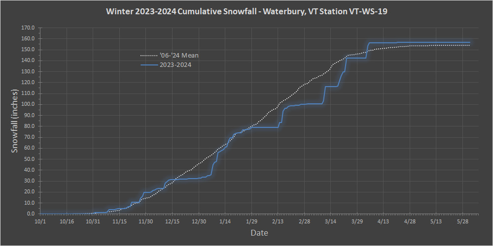
If the NNE cold season thread is starting, it must be that time of year, so I figured it was a good time to put together the final numbers at our site for the 2023-2024 winter season. It turns out that we’re already well into the new snow season here in Vermont, since we had snow back on September 9th at Jay Peak., and I guess we’re already into our next snow event and first accumulations from the current upper level low based on PF’s recent report and photos from Mt. Mansfield. Now for some data and highlights from the 2023-2024 winter season at our site. In terms of overall snowfall, it was a solid, respectable season – snowfall came in at 156.7”, which is near average and an improvement of about a half foot above the previous season. As shown in the seasonal snowfall progression plot below, we spent more time behind average snowfall pace than ahead of it, only catching up to or slightly surpassing average pace during the strong November and January periods. The very strong finish in March and April is quite evident on the plot and that undeniably helped the season recover from what would have been a subpar result. The season snowfall rank of 8 out of 18 seasons puts it just in the top half of the pack and is another nod to the decently average nature of the season. November was an interesting month last season – it ended up being quite a standout, but in a stealthy way. The November snowfall of 19.9” was only a few inches above average, so not especially notable, but November quietly set a different record for the month: days with snowfall. November 2023 had 19 days with new snow, besting the previous record of 18 days for November 2018. In line with the numerous snowfall days, there was snow on the ground for 19 days of the month. That’s not a record by any means (three other seasons have 20+ days of November snow cover), but it’s well above the average of 12 November days with snow on the ground, and with the initial accumulating snows moving in right on the first of the month, it certainly helped crank up the holiday vibe right from the start. The continuous season snowpack did start on November 19th, but it wound up being touch and go in December when the snowpack start date almost reset because of the slow second half of the month. We had 10 accumulating snowstorms this past November, which is above the average of 6 storms. That’s a robust performance, but it only earns an honorable mention because along with November 2018 it tied for second place behind November 2019 with 12 storms. On a related November note, this past season marked the eighth white Thanksgiving in a row, and that now brings the average up to near 75% for snow on the ground for turkey day. January was the other month that claimed some records for the season. January snowfall of 46.1” was above average, but only modestly so, since it was still within 1 S.D. So, while not special in terms of overall snowfall, it was in other snowfall-related categories where the month set one record and tied another. The record set was the number of storms for the month with 19, and that total didn’t just break the previous record, it absolutely smashed it. The 19 recorded storms blew right past the second-place contender of January 2023, which had 14 storms. In fact, this past January has now assumed the top position in that category for any month – the previous record holder was December 2013 with 16 storms. It wasn’t that this past January was especially notable with respect to upslope snowfall, it just wound up presenting a solid parade of both larger and smaller systems, and the details for those 19 January storms can be found in the detailed 2023-2024 storm list below. In line with all those storms, the record that was tied this past January was days with snowfall at 29. Even though this past January only tied January 2020 for snowfall days, it’s still an impressive number when you think about it because that means there were only two days during the entire month where it didn’t snow. That’s some strong consistency with respect to snowfall, even for around here in the Northern Greens. Mother Nature certainly decided to take care of the VT snow globe requirements this past January. Total Snowfall: 156.7” Season Snowfall Rank: 8 of 18 October Snowfall: Trace November Snowfall: 19.9” December Snowfall: 13.0” January Snowfall: 46.1” February Snowfall: 21.4” March Snowfall: 42.1” April Snowfall: 14.2” May Snowfall: 0.0” Total Days with Snowfall: 99 October Days with Snowfall: 1 November Days with Snowfall: 19 December Days with Snowfall: 15 January Days with Snowfall: 29 February Days with Snowfall: 17 March Days with Snowfall: 11 April Days with Snowfall: 7 May Days with Snowfall: 0 Snowstorms: 54 October Storms: 0 November Storms: 10 December Storms: 8 January Storms: 19 February Storms: 10 March Storms: 4 April Storms: 3 May Storms: 0 Average Snowfall per Storm: 2.9” Largest Storm:15.9” 2nd Largest Storm: 13.9” 3rd Largest Storm: 12.5” 4th Largest Storm: 11.2” 5th Largest Storm: 10.4” Sum of 5 Largest Storms: 63.9” Storms ≥10": 5 Date of Largest Storm: 3/9/24 Earliest Frozen Precipitation: 10/29/23 Earliest Accumulating Snowfall: 11/1/23 Earliest 1" Storm: 11/1/23 Earliest 2" Storm: 11/9/23 Earliest 3" Storm: 11/22/23 Earliest 4" Storm: 11/28/23 Earliest 6" Storm: 12/12/23 Earliest 8" Storm: 1/7/24 Earliest 10" Storm: 1/8/24 Earliest 12" Storm: 3/11/24 Latest Accumulating Snowfall: 4/22/24 Latest Frozen Precipitation: 4/25/24 Length of Snowfall Season: 174 days Start of Season Snowpack: 11/19/23 October days with Snowpack: 0 November days with Snowpack: 19 December days with Snowpack: 31 January days with Snowpack: 31 February days with Snowpack: 29 March days with Snowpack: 31 April days with Snowpack: 12 May days with Snowpack: 0 Days with >0" Snowpack: 153 Days with ≥1" Snowpack: 103 Days with ≥6" Snowpack: 61 Days with ≥12" Snowpack: 15 Days with ≥24" Snowpack: 0 Days with ≥36" Snowpack: 0 Max Snow Depth: 16.0” Date of Max Snow Depth: 1/17/24 End of Season Snowpack: 4/11/24 Continuous Snowpack Season: 145 days Snow-Depth Days: 768.0 inch-days Total liquid equivalent: 28.06” Frozen liquid equivalent: 12.76” % Frozen L.E.: 45.5% Total Snow/Total Liquid Ratio: 5.58 Total Water Content: 17.9% Total Snow/Frozen Liquid Ratio: 12.28 Frozen Water Content: 8.1% 2023-2024 Winter Storm List 11/1/23: 1.5” Decaying shortwave trough 11/7/23: 0.4” Low pressure system passing through southern Canada 11/9/23: 2.0” Surface low moving across the Adirondacks and through Vermont 11/13/23: 1.1” Low pressure passing well north of region 11/19/23: 1.7” Shortwave rounding the base of longwave trough centered over Northeastern U.S. 11/21/23: 3.9” Low pressure from Great Lakes/Ontario redeveloping into coastal low traveling through southern New England 11/24/23: 0.2” Cold frontal passage 11/26/23: 3.7” Winter Storm Cait - Low pressure redeveloping off Mid Atlantic Coast and lifting northeastward through New England 11/27/23: 1.0” Lake-effect enhanced snow showers from Lake Ontario 11/28/23: 4.4” Weak cold front swinging through the region 12/3/23: 2.1” Low pressure slowly trekking along the international border 12/5/23: 1.4” Upper-level trough passing south of region with several pieces of shortwave energy rounding the base 12/10/23: 6.0” Strong, dynamic storm with low pressure passing over eastern Massachusetts 12/12/23: 2.2” Cold frontal passage with northwest flow & squalls 12/19/23: 0.2” Upper-level low swinging through the area 12/21/23: 0.1” Flakes blowing over from Lake Champlain lake-effect snow band 12/23/23: 0.5” Decaying mid/upper-level cyclonic circulation north of Lake Ontario, with bands of moisture rotating across our area 12/29/23: 0.5” Weak low pressure scooting along the international border dragging a weak cold front along in its wake 1/1/24: 0.6” Localized Stowe & Waterbury Vermont snow bands 1/3/24: 1.5” Sharpening upper-level trough moving in from the west with cold front 1/5/24: 0.7” Weak cold front dropping south across the area 1/6/24: 0.1” Shortwave energy with weak frontal boundary dropping through northern New York and Vermont 1/6/24: 11.2” Winter Storm Ember - Deepening low pressure system off the Delmarva peninsula tracking along the New England coast 1/9/24: 8.9” Winter Storm Finn - Powerful low-pressure system pushing into the Great Lakes 1/11/24: 0.2” Moist westerly flow off Lake Ontario 1/11/24: 1.8” Weak low pressure/upper-level shortwave traversing the international border 1/13/24: 1.7” Winter Storm Gerri - Powerful storm system lifting across the central Great Lakes 1/14/24: 1.7” Ontario lake-effect moisture and embedded snow squalls 1/16/24: 8.1” Winter Storm Heather - Intensifying coastal storm moving from mid-Atlantic to Cape Cod 1/17/24: 0.2” Lake effect snow showers 1/18/24: 3.2” Arctic cold front 1/20/24: 1.4” Surface trough with relatively deep moisture pushing south over the international border 1/23/24: 2.7” Winter Storm Jarvis - Stalled frontal boundary from central New York state to southern New England moving north across the area 1/26/24: 0.3” Surface low pressure tracking east-northeast across the Catskills and coastal New England 1/27/24: 0.1” Upper-level trough passing across the North Country 1/27/24: 0.5” Weak confluence aloft from combination of northerly and northeasterly flows 1/28/24: 1.2” Coastal low pressure tracking within the benchmark and upper-level low crossing the region 2/12/24: 0.1” Frontal boundary across southern Quebec 2/13/24: 4.3” Potent shortwave passing through upper-level flow 2/15/24: 10.4” Quick moving moisture-ridden clipper 2/17/24: 2.7” Shortwave swinging through the BTV NWS forecast area 2/18/24: 0.2” Lake effect snow with south/southwest flow 2/18/24: 1.6” Arctic boundary with snow showers and embedded heavier snow squalls 2/20/24: 0.4” Light snow showers on northwest flow 2/22/24: 0.5” Weak low pressure tracking through the North Country 2/26/24: 0.9” Weak wave of low pressure moving through the area 2/28/24: 0.3” Strong cold frontal passage across the region 3/9/24: 15.9” Powerful late winter storm with deepening low passing through southern/central New England becoming vertically stacked in central/northern Maine 3/18/24: 5.7” Polar longwave trough with upper-level low pressure spinning just northwest of Montreal 3/20/24: 8.0” Potent piece of northern stream shortwave energy 3/23/24: 12.5” Winter Storm Ronnie - shortwave in northern stream phasing with energy from a southern stream system 4/3/24: 13.9” Winter Storm Tormund - Secondary area of low pressure forming over Chesapeake Bay and tracking through eastern Massachusetts 4/20/24: 0.2” Cold front and potent upper-level trough 4/22/24: 0.1” Strong cold front
-
As others noted, we actually had our first VT flakes of the season back on September 9th based on reports and video from Jay Peak. The flakes from that cool period last month sort of flew under the radar though – it was probably a week later before I ended up hearing about it by chance.