J.Spin
-
Posts
6,282 -
Joined
-
Last visited
Content Type
Profiles
Blogs
Forums
American Weather
Media Demo
Store
Gallery
Everything posted by J.Spin
-
Was it seriously just six days ago that you were so optimistic? It feels like it was weeks ago at this point. I hadn’t realized that people were visualizing a “cold” pattern for the rest of the month – to me it just looked like it was going to be active, with our typical November snow chances. I’d think for a consistently cold pattern, we’d need to see a persistent trough in the area, and I don’t recall the models ever showing that. We’ve definitely had the snows – multiple systems at this point, and the models suggest there are more to come. I’d say there are at least three more storms with possible snow in the models? – the back side of this current system, something near the beginning of next week, and then something near the end of next week. PF has pointed out how it’s not looking like a great period for snowmaking down to base elevations, so that’s obviously tough on the resorts if they’re planning to open top-to-bottom. I’m more interested in getting out for natural snow turns though, so every storm with snow is an opportunity for that. I’ve been a bit too busy the past couple of weeks to venture out for turns, and it felt like it was still just a bit thin down low, but I’m definitely watching each storm that comes through for the next possibility.
-
I’d argue from experience that parts of NNE/NNY are almost always in play from any system through the heart of winter – between the elevations of the mountains, the areas covered by LES, the latitude all the way up to Northern Maine, and prominent CAD sites, you really have to have extreme warmth to take that entire region out of the game. I guess it depends on what you definition of “in play” is, but mine is the possibility of at least some snow/frozen from the system, and it’s the rare system in midwinter where there isn’t the chance of at least something for this neck of the woods. Many of our events are not going to garner a lot of interest in the main thread though.
-
Yeah, I was going to message in about the stunning views around here today – enjoying the west side sights of the spine from my office right now. The sights aren’t nearly as brilliant now that the clouds have moved in, but it’s great to see that snow line way down there. I grabbed a quick shot of Mansfield with the cell phone:
-
Event totals: 1.8” Snow/0.87” L.E. I’ve got my observations below from when I got home yesterday evening, and I’d say that’s the end of that system, so the above totals should be the final numbers at our site. At elevation, where this system was mostly snow, this was a great shot to the snowpack. Unfortunately I’m not seeing any recent snowpack data at the Mt. Mansfield Stake to get a sense for where it stands at the moment to think about whether or not this could represent the start of the season snowpack. If there’s a foot or so of dense snow up there, this certainly could be the start of the snowpack. With this system having wound down now, it looks like the next systems with snow potential are the one coming through tomorrow into Friday, and then maybe something early next week. Details from the 8:00 P.M. Waterbury observations: New Snow: 0.2 inches New Liquid: 0.11 inches Snow/Water Ratio: 3.6 Snow Density: 27.5% H2O Temperature: 29.5 F Sky: Cloudy Snow at the stake: 1.0 inches
-
-
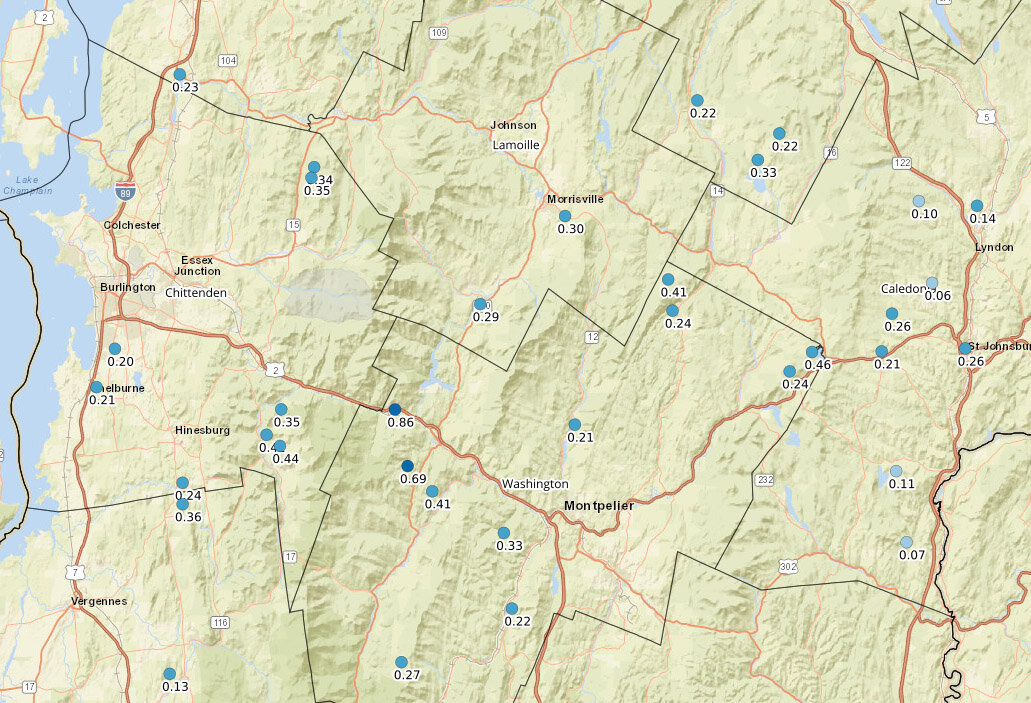
We were getting some decent snowfall out of that as the stronger echoes came through. Accumulation was still relatively slow due to the marginal temperatures and relatively small flake size, but you can see from the CoCoRaHS L.E. map how it’s added to the total liquid from this event in our area:
-
I guess this event isn’t quite done yet because it even started snowing here in Burlington – I see on the radar that it’s got the look of a big batch of streamers on WNW. It seems to be hitting the mountains now, so you might get an uptick in snowfall if the spine does its usual thing.
-
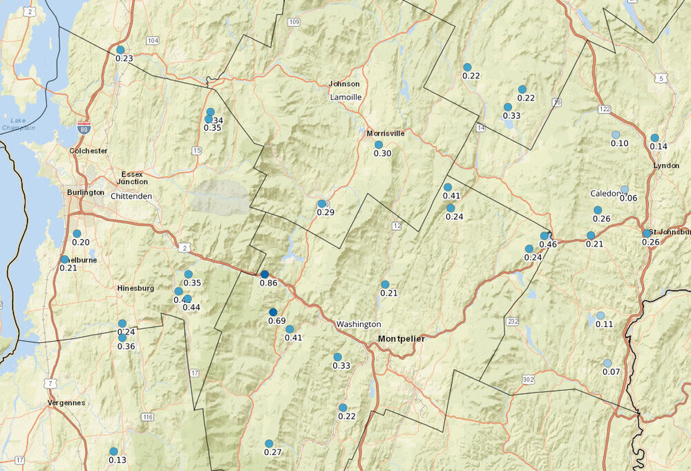
Event totals: 1.6” Snow/0.86” L.E. We’ve had a good shot of liquid with this system so far at our site. It wasn’t until later in the day yesterday that it really started to accumulate here, but if we’re at 0.86” of L.E. so far, the local peaks must be around an inch of L.E. by this point, with a lot of that as snow up high. There’s only a weak radar signature out there right now, but we’ve been getting some steady light snow this morning to add a bit more accumulation. Flakes have been small (1-2 mm though), so I don’t expect accumulations to amount to too much unless that changed. I’ve got my past couple of rounds of observations below, and some travel observations from yesterday. I was heading home a bit late from Burlington in the evening and the temperature was 37 F. At that point there was no precipitation in the Champlain Valley, and roads didn’t even start to get wet until I got into the mountains. I was surprised to not see any snow until I approached the town of Bolton, and then everything changed in what seemed like an instant. The road was covered with an inch or two of unplowed slush, and it definitely pushed you around while driving. At home the temperature was 33 F, and the slush on the road had almost disappeared relative to what I’d seen in Bolton and Bolton Flats. Here are the past couple round of observations from our site: Details from the 8:00 P.M. Waterbury observations: New Snow: 0.4 inches New Liquid: 0.11 inches Snow/Water Ratio: 3.6 Snow Density: 27.5% H2O Temperature: 33.6 F Sky: Light Snow (1-2 mm flakes) Snow at the stake: 0.5 inches Details from the 6:00 A.M. Waterbury observations: New Snow: 1.2 inches New Liquid: 0.22 inches Snow/Water Ratio: 5.5 Snow Density: 18.3% H2O Temperature: 32.5 F Sky: Light Snow (1-2 mm flakes) Snow at the stake: 1.0 inches
-
I saw on the Sugarbush Summit Snowboard Cam that they had 8-9” on their board as of this evening, but I don’t think they’d cleared it since the previous storm? It looks like one of the snowmakers cleared it about 20 minutes ago (you can go back in the video and see him doing it and that it was a bit of a stretch at times; the board is pretty elevated without much snowpack in place yet).
-
Look at the flow right now, it’s basically perpendicular right into the spine.
-
I’ve got an update from the Winooski Valley this morning – snow line was around 1,500’, so that’s where it seemed to settle in by the morning hours in that area. I saw a car that I assume came down from Bolton that seemed to have about an inch of snow on it, and their base area webcam at 2,100’ shows that they definitely got a refresher of the previous snow.
-
Updates on the running accumulation at your snow plot are great – what’s the elevation there again (I know it’s somewhere in the 3,000’ range)? It certainly looks like there will be chances for additions to the November total going forward.
-
We had 0.42” of liquid with this first system, but I’m seeing higher amounts the farther wester toward the western slopes you go. How much L.E. for the mountain thus far? I’m assuming one had to go up to roughly ridgeline elevation to have it all/nearly all fall as snow?
-
That looks like the next opportunity – with a lot more potential on the back side vs. this last one. If indeed this current pattern holds for a couple of weeks as I saw mentioned on TWC the other day, you can see how a number of similar events could roll through by the end of the month. Even if you just continue to get 4-6” here, 4-6” there, with a couple systems having a bit more punch, it could bring accumulations in the Northern Greens in the realm of bwt’s comment about that GFS snow map.
-
We had precipitation linger a little while after that main shield cut off, but it was indeed quite dry on the back side – there just wasn’t much of a hookup with additional moisture as that dry air moved in. Down here at our elevation I could see that we got into the snow, but there was never any accumulation that I could detect. For accumulations in the higher elevations around here I’m seeing ~4” on the Sugarbush 3,900’ webcam, ~2 on the Sugarbush 3,125’ webcam, and at the Bolton Valley 2,100’ webcam it looks like accumulations in the 1-2” range.
-
We’re already starting to get frozen precipitation down here at 500’, so the snow level is definitely descending now. For accumulations on the Sugarbush cams I’m seeing ~0.5” at 3,125’ and ~3” at 3,900’.
-
I’m totally on board with your accumulations estimates, but I just don’t know if the snow is going to shut off that fast without any backside lingering like we typically see. It seems like once those initial pulses push through, there’s almost always some snow that hangs around as the back side of the system moves through and some winds shift.
-
LOL, I didn’t know if you’d be up at the mountain today – but your observations seem to line up right with what was showing up on the Sugarbush Summit Cam. The Bolton summit cam at ~3,100’ has been showing some snow now as well. There are many high elevation options around now to watch that snow level drop in the Northern/Central Greens. Jay Peak needs to get their act together with respect to an upper mountain cam as well; they of course have an amazing spot for monitoring snow in the range.
-
I don’t know about those lower elevations, but Mansfield hour forecast has it snowing through 1:00 A.M., so I don’t think the snow has to fall in just a few hours. The precipitation has already changed over to snow on the Sugarbush Summit Cam up near 4,000’, so presumably the peaks farther north have changed over as well.
-
Even if that projected liquid ends up being a bit high, it’s hard to imagine that it’s not going to be a good shot of snow from 3,000’ on up. The Mansfield point forecast has precipitation changing over to snow just a couple of hours from now, the temperatures don’t even go above freezing until midweek, and the next few days suggest plenty of snow chances. It depends on what elevation you’re talking about, but in the region of your upper mountain plot, it sure looks like snow is on the way.
-
Well, I think most of the discussion ended up being about Northern Greens climo in the end. From what I’ve seen, those maps tend to get a bad rap because they can cover extended periods where accuracy wanes, and they apply a variety of (sometimes-flawed) algorithms in simplistic ways. It seems the even bigger knock against them is that weenie types tend to post them to somehow bring the tiniest pinch of faint reality to their unrealistic, sensationalistic snow dreams. If those maps occasionally happen to approach actual climo and reality, we just roll with it I guess.
-
The 18Z GFS map below presumably covers the period you’re talking about – it goes through the 28th, which is Sunday of Thanksgiving weekend. That obviously spans a couple weeks out from today, and we know the reliability of models beyond about a week, but whatever happens, that’s simply not very far-fetched for the spine of the Northern Greens in November if one just thinks about average snowfall. If we average ~15” here at our site in November, that means that sites at elevation along the spine around here (such as the upper elevations of Jay Peak and Mansfield) should average ~30” in November. PF may be able to tell you what his 3,000’ plot averages for November, but he may not have solid monthly data if he doesn’t start diligently monitoring until the resort opens. It’s hard to tell exactly how much snowfall the map is suggesting along the spine, but let’s say ~40” based on the coloring. That’s not even LOL-worthy; we’ve had almost that much down at our house just in the last 20 days of November before, so for Jay Peak or Mansfield to pull that off would be a piece of cake. At this point, it’s becoming more and more apparent that this isn’t lining up to be one of those Novembers with wall-to-wall above average temperatures that result in little if any snowfall. So I’d argue that the snowfall projected on the map isn’t really outrageous, but skiing Starr or the Face Chutes would probably be pushing it. It’s November, so there’s really no base in place, and unless we get 40” of absolute cement (not our typical density), that amount of snow isn’t quite going to cut it for that terrain. It’s November, so even if getting 40” for the spine isn’t outrageous, having no melting between snowfalls could be tough to pull off. I don’t know about the rest of the locations on there, but that snowfall depicted along the spine of the Northern Greens in the map could certainly be achieved.
-
Unfortunately, you can’t get a feeling for what the map suggests in the area where the Winooski Valley passes through the spine, since it’s covered by the I-89 icon. If the accumulation gradient is based simply off elevation, then I guess it would be that base, light blue shading as shown for the Lamoille Valley. It’s always fun to see what happens here though because sometimes we get that orographic enhancement that boosts precipitation rates and lowers snow levels below what they would be without the terrain (as I think you mentioned in a discussion the other day).
-
I’m sure you’ve seen the BTV NWS AFD, but they have snow getting down to similar levels: Area Forecast Discussion National Weather Service Burlington VT 724 PM EST Thu Nov 11 2021 SHORT TERM /SATURDAY THROUGH SATURDAY NIGHT/... As of 335 PM EST Thursday...main forecast points remain valid from the previous runs. Snow levels will lower into the 1000-1500 range with potential for some accumulating snow. Current estimates favor 1-2 inches of snow for elevations down to around 1200ft with 2-4 inches for higher terrain. Very light slushy accumulations will be possible down to around 800ft during the heaviest precipitation period: 00Z Sun through 06Z Sun. For the Northeast Kingdom, consensus forecast amounts are around 1-3 inches, but there are some scenarios that show up to 5 inches possible. The higher amounts would occur if more convective elements were present along and ahead of the wave which some mesoscale models are beginning to show the potential for or if the deepening of the wave slows its exit somewhat.
-
I typically find that the models/forecasts up to about a week out are reasonably good for dialing in specific storms/events when we’re in a bread and butter-style pattern and no phasing is required. That’s definitely helpful in planning which days/times to head out for turns, and that’s bona fide utility right there in the models. I’m sure the accuracy for what we’re getting there is well improved from a couple of decades ago, because it’s often very good. Most of the time all I need to do is pop up the GFS MSLP/Precipitation frames on TT, check on what it shows for the next several days, cross check with the BTV NWS forecast discussion, and then watch as the shortwaves roll through as predicted. To me that seems like a real high level of practical utility coming from my tax dollars at work. Beyond that roughly one week timeframe though, I just don’t get the utility in the models. Sure, one can get a sense for patterns that set up “storm chances” or snowy periods, but, without specific dates for storms, or any real certainty that they’re going to happen, what’s the point? Does anyone really change anything in their life based on what the “weeklies” show? Just about all we ever hear about on here is how poorly they perform anyway. So who’s going to modify their schedule or do anything differently based on what these extended models show, when they’re often not correct, and even if they are correct, the information, by necessity, is so vague that it’s not useful for planning anything anyway? I certainly agree with your comment though, and I think the combination of now being far enough along into the mid-month period and the apparent residency time of the upcoming pattern speaks to some potential. We look like we’re entering a pattern beyond Saturday where just about every system has a good shot of bringing some snow to the NNE mountains - even if the systems are not 100% snow (which is essentially the situation all winter long anyway). Dr. Postel this morning on TWC did say that it looks like the upcoming pattern could persist for a couple of weeks, which would get well into the back half of November. Unfortunately, the forecast doesn’t tell me which specific days to plan to ski yet, but perhaps we’re getting to the point where the mountain snowpack will start to build at elevation.