J.Spin
-
Posts
6,296 -
Joined
-
Last visited
Content Type
Profiles
Blogs
Forums
American Weather
Media Demo
Store
Gallery
Everything posted by J.Spin
-
Well, whether it ends up being ± whatever actual amount of liquid equivalent in the end, I find that on average, the GFS is the best of the tools in that medium range timeframe for northern stream and upslope systems in the Northern Greens. The ECMWF model is quite good in general of course, but it and the other medium range models just don’t seem to “see” the mountains around here in the same way with whatever physics they implement. In any event, the BTV NWS is already paying attention to the potential from Tuesday through the end of the week. It is fitting though to see a quote from the experts that says: “…and with a tendency for these events to last on the longer side of guidance, trended toward this solution.” As someone who lives along the spine of the Northern Greens and routinely documents the snowfall from these events, that seems to be an aspect that the GFS typically “gets” more than some of the other equivalent models. It’s also interesting to hear about the difficulty in using ensemble data as effectively for these types of events because it’s too coarse to resolve the terrain well. LONG TERM /TUESDAY NIGHT THROUGH SATURDAY/... As of 339 AM EDT Sunday...Upslope precipitation begins Tuesday night and will continue through Wednesday. The mountains should see exclusively snow, and with steep lapse rates, much of it should be powdery. As temperatures rise during the day Wednesday, there could be a little rain mixing in in the valleys, but the steep lapse rates could cause it to be all snow despite temperatures well above above freezing. The precipitation will be snow everywhere Wednesday night. There is some uncertainty on when the upslope precipitation ends. Some guidance keeps it going all the way through Thursday, and with a tendency for these events to last on the longer side of guidance, trended toward this solution. However, snow would likely be lighter and more scattered on Thursday as the depth of the atmospheric moisture declines. Ensemble probabilities are tough to use in these upslope cases since they are too coarse to resolve the terrain well, so looking at the deterministic guidance, several inches look likely in the northern Greens and Adirondacks, with the possibility for significantly more. It looks like the upslope precipitation should taper off by Friday at the latest, and ridging will briefly build into the region to end the week.
-
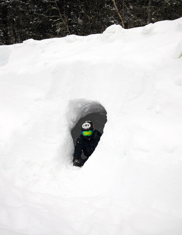
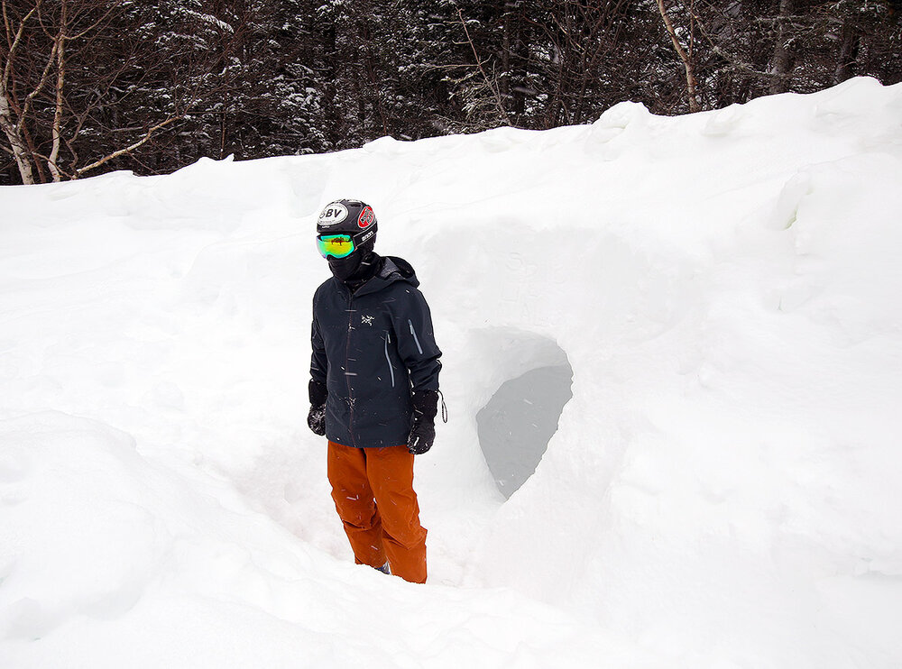
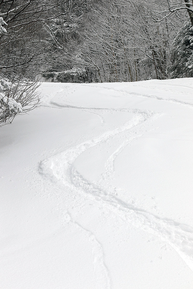
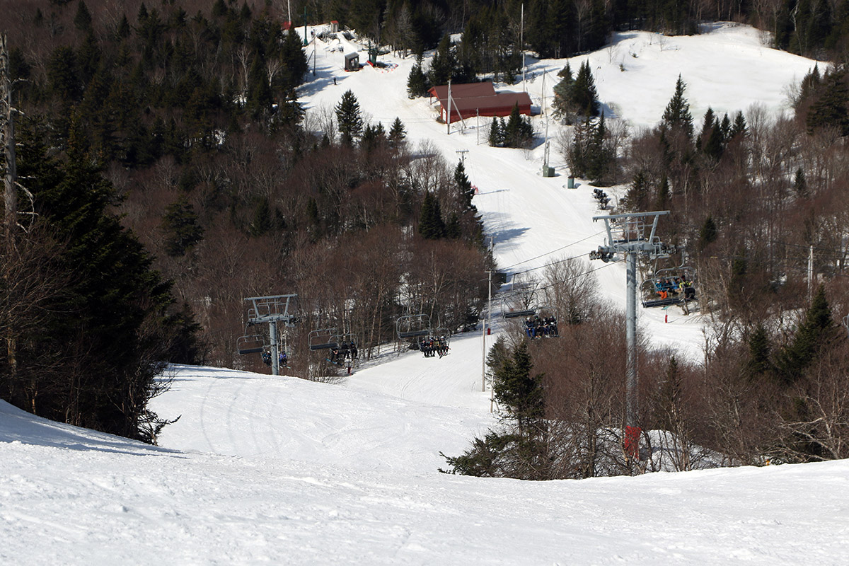
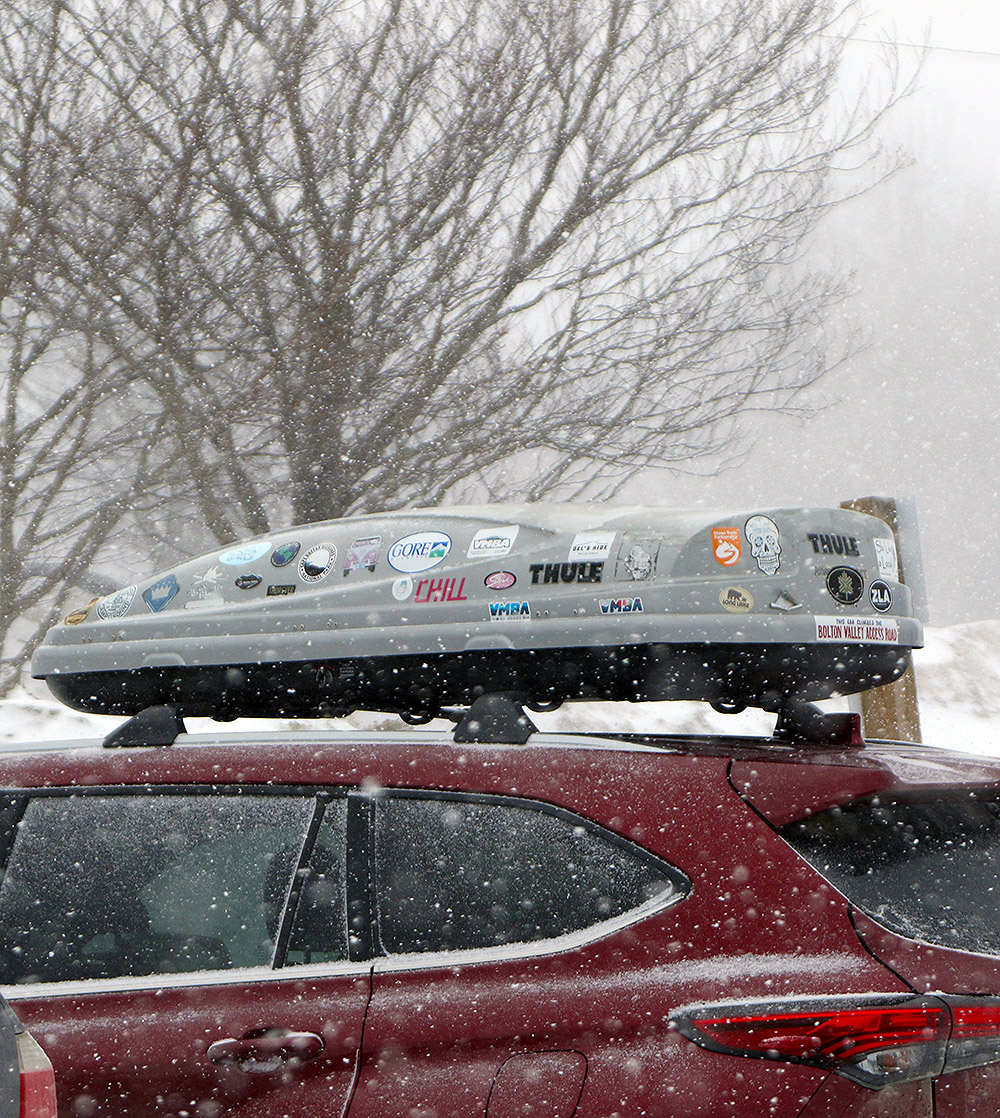
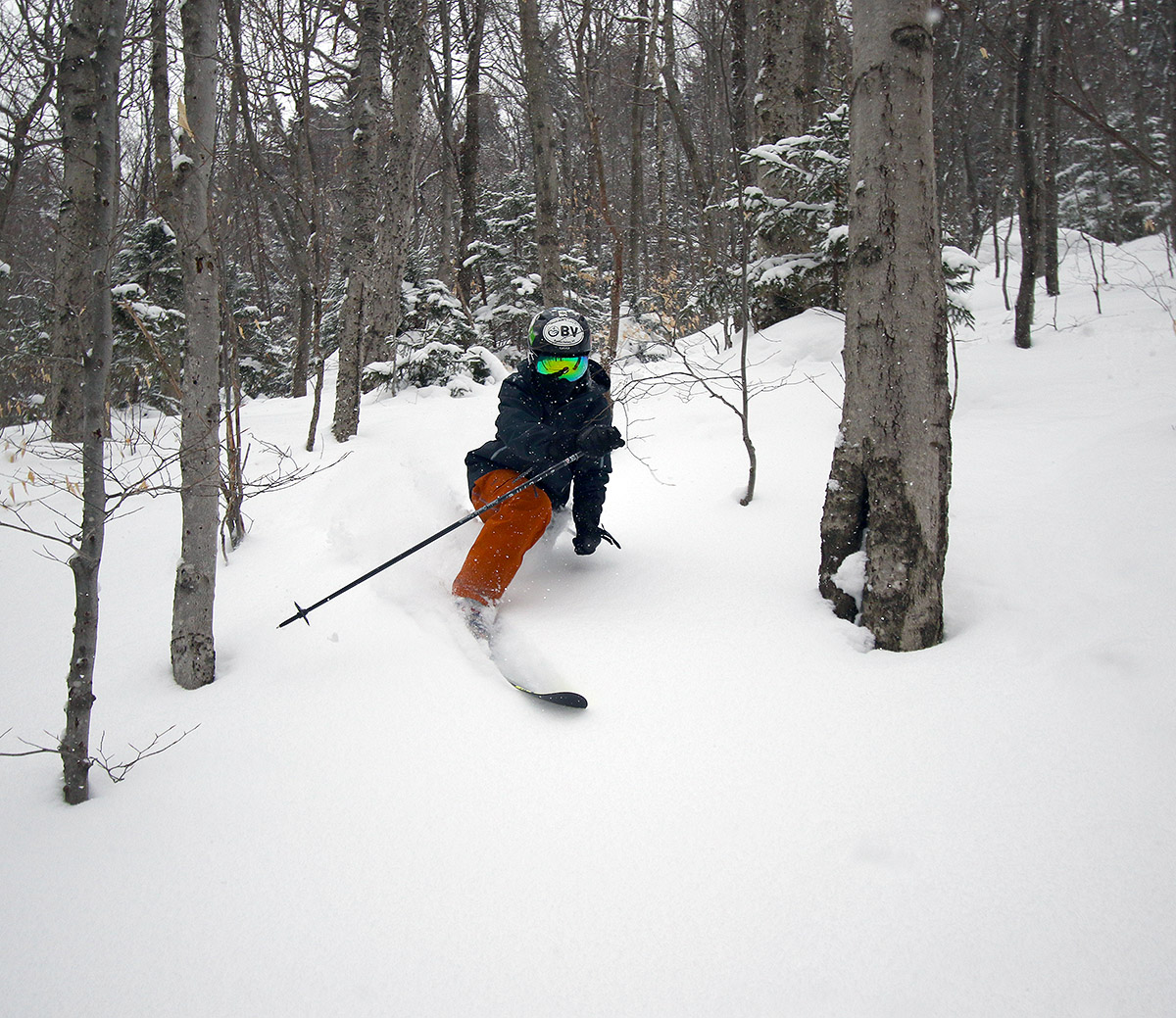
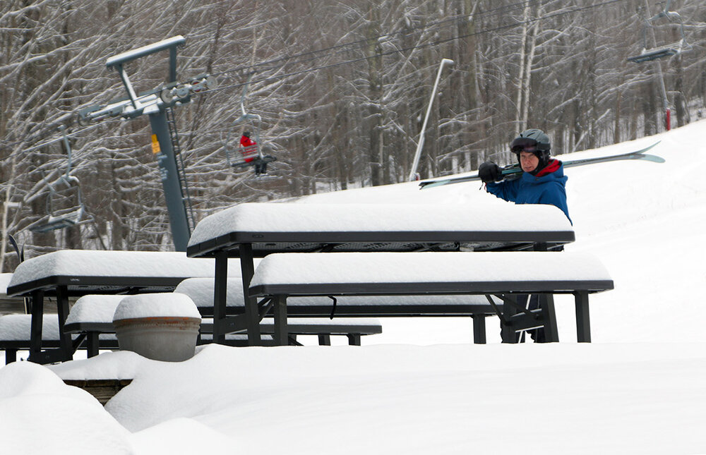
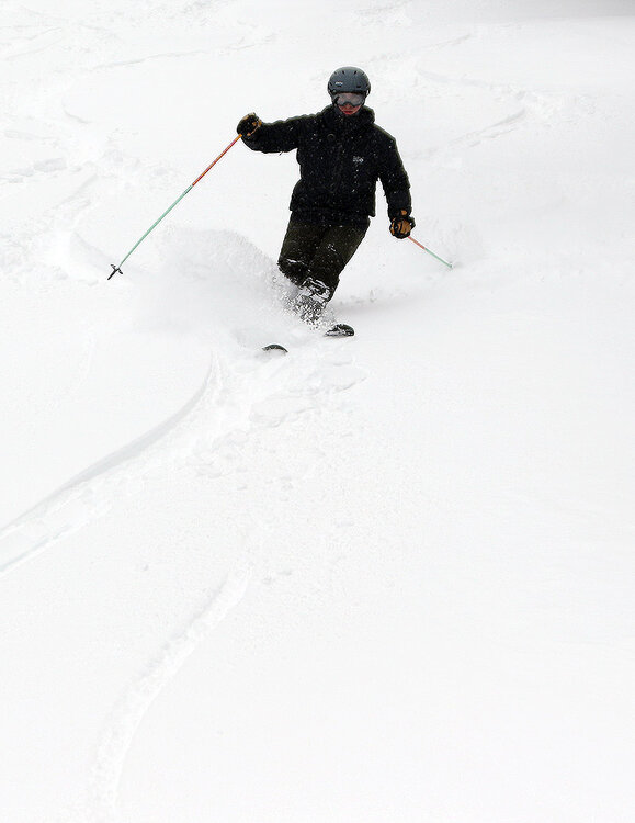
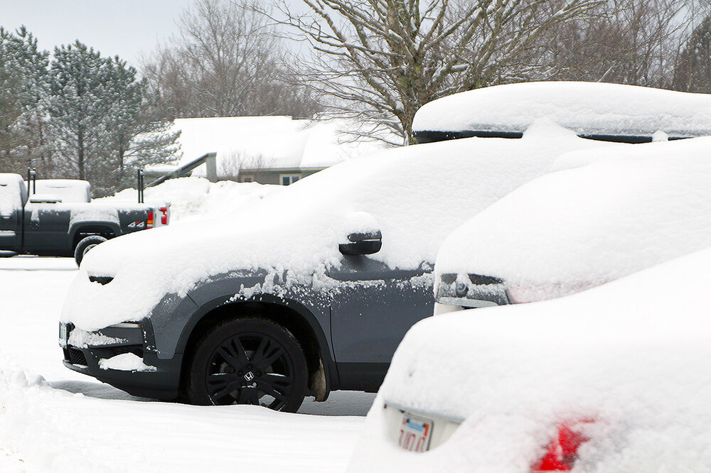
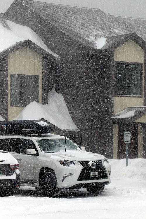
It’s April in the Northern Greens, and our most recent storm came through the area yesterday, finishing up overnight with 4-8” of snow in the valleys and 12”+ for the local ski resorts. Bolton Valley was reporting 13” of new snow from the system in their early report, so I hit the mountain this morning for some touring in the fresh powder on my way to Burlington. The ongoing April temperatures, rounds of new snow, and the upcoming forecast have been decent enough that Bolton has decided to add some extra innings to their operations schedule this week, but they weren’t starting up the lifts today until noontime. That meant that the resort was on the quiet side this morning; only about ¼ of the upper Village lot had some cars from folks out ski touring and taking care of other things at the resort. My car’s thermometer was reporting temperatures in the mid-teens F when I started my morning tour, but even if you weren’t in direct sun, you could tell it was April – the solar radiation is just that strong at this time of year. The weather overall on the mountain today was a gorgeous April mix of light to moderate snow at times, scattered clouds, and frequent breaks of direct sun. The system that brought the snow was pulling away and there wasn’t really any wind behind it, so it was warm enough to be comfortable but still well below the point where temperatures would have affected the quality of the powder. And indeed, although this was an April storm system, the powder it delivered was midwinter dry. Down in the lower valleys, the snow did start out on the denser side for the very beginning of the system; my liquid analyses indicated 8-12% H2O snow during the day yesterday, but the bulk of the snow fell overnight, and that snow density was in the 3-5% H2O range. While the wind had dissipated by this morning, there was definitely some wind with the system, because the effects of the drifting on the dry snow was evident. As long as you avoided scoured areas though, bottomless powder turns were readily available. When I saw the storm total exceeding a foot up at the resort, I decided it was another day for the fat skis, and they were indeed an appropriate tool for the job. There was quite a snowfall gradient with this storm as one headed up from the valley, and there was a real solid jump in accumulations between 1,500’ and 2,000’ that made touring out of Bolton’s main base area the clear choice. Here’s the accumulations profile I found from this morning’s outing: 340’: 1” 1,000’:1-2” 1,500’: 3-4” 2,000’: 7-9” 2,500’: 8-12” 3,000’: 12”+ I went on the conservative side with accumulations in those upper elevations, but there were plenty of areas with a good 12-13” at 2,500’ and 15-17” at 3,000’ that weren’t drifts. I just couldn’t find those depths consistently enough to call them representative overall for those elevations. In this morning’s report, Bolton Valley was at 374” on their season snowfall total, and as we approach mid-April, the ski resorts in the Northern Greens are generally reporting season snowfall the ±400” range. That’s above average, and it looks like another April system may be hitting the area this weekend with more potential snow for the mountains, and there could be additional snow next week as well.
-
It looks like that was a decent call – I’m seeing a lot of 4-8” totals for the valleys and 12”+ for the elevations.
-
Based on the weather, yesterday really wasn’t a day that I would have typically hit the mountain for skiing. It was one of those spring “in between” days, where temperatures weren’t cold enough that we were getting fresh snow, nor was it warm and sunny enough that we were really getting a nice spring skiing day. But my younger son and a number of his friends were heading out to partake in Bolton Valley’s pond skimming portion of their big “Spring Thing” event, so we decided to head up to check that out and get in some skiing. From what the website indicated, this was the first time they’ve put on a pond skimming event in about a decade, and they were also trying out dual slalom mountain bike races on snow - which seems like a pretty unique event. I typically shy away from skiing on these middling spring days because you can end up with hard snow surfaces without either enough fresh snow to cover them up, or enough warmth to soften them up. Surprisingly though, the snow yesterday ended up being fine. Even though the temperatures on the mountain were only around 40 F at the base, and it wasn’t sunny, the surfaces had softened into some nice spring corn snow. Snow surfaces were just a bit firmer up near the ridgeline above 3,000’, but even there they were soft enough to be corn. The weather took a turn as we approached midday and precipitation moved in. It was a combination of sleet and rain, and while it didn’t really affect the snow surfaces, riding the lift and skiing were much less pleasant because of the precipitation falling. We headed out at that point, but from what I saw on the radar, that precipitation eventually pushed through by later in the afternoon when the resort was running the bike races.

-
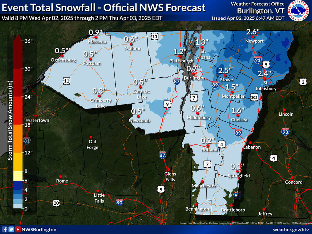
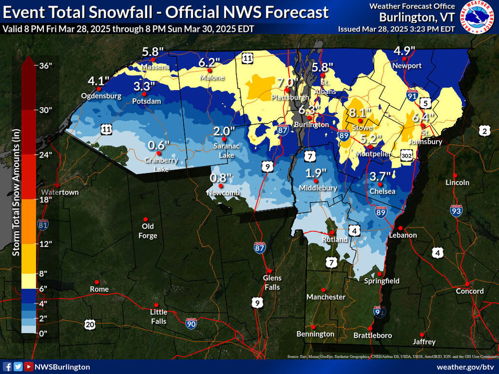
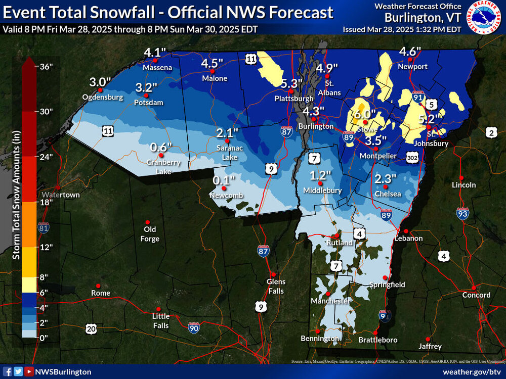
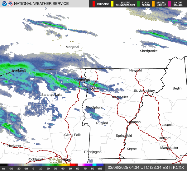
I saw on TWC this morning that the snow in our point forecast had been increased for this next incoming system, so I stopped in at the BTV NWS site to check on their updates. There was a substantial expansion to the coverage area of the Winter Weather Advisories and some increases in projected snowfall amounts on the Event Total Snowfall map.

-
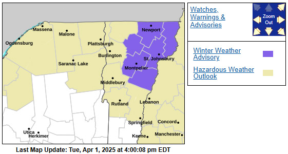
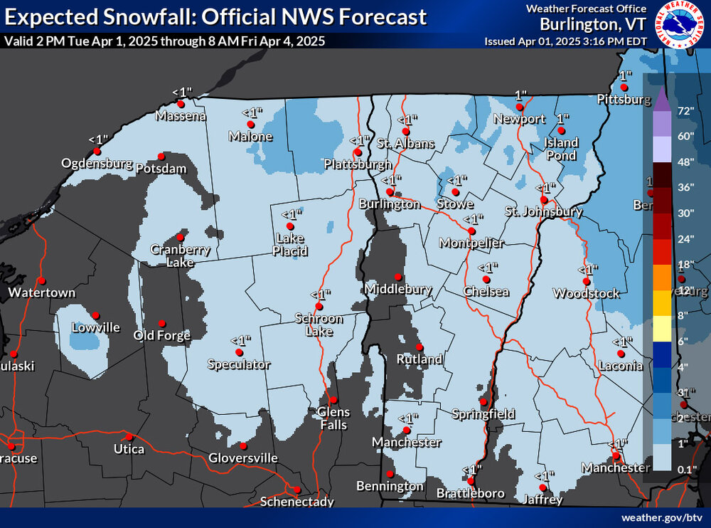
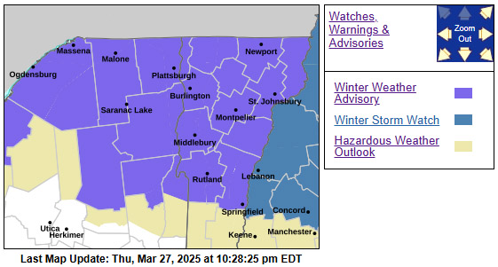
Earlier this afternoon I received an alert that we’d been put under a Winter Weather Advisory for the weather coming into the area tomorrow. I haven’t seen the updated BTV NWS forecast discussion yet, but in the available discussion they mention “a winter wx advisory type of an event is expected from the combination of snow changing to freezing rain/sleet, followed by rain on Thursday midmorning.” The headline link just brings one to the standard winter weather page and the map suggests an inch or two of snow at this point.
-
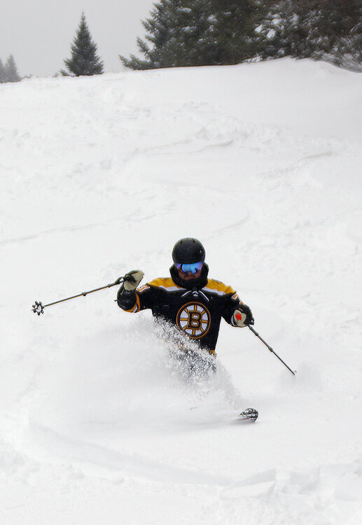
Snow from our latest winter storm began to fall late Friday evening, and then it really hit hard overnight with snowfall rates of an inch per hour or more that lasted into the early morning. Bolton Valley was already reporting 8 inches of overnight snow as of their early 6:30 A.M. report, with more snow still to come. My liquid analyses from down in the valley indicated that we’d picked up ¾ inches of liquid equivalent in the snow at that point, so the mountain probably picked up in the range of an inch of liquid equivalent, and you could feel it in the snow. The snow at our site came in right around 10% H2O, so this storm generally brought medium weight powder. Even on the mountain the new snow fell with minimal wind, so it was a very even coating across the entire resort that set up some excellent skiing both on and off piste. My wife and I headed up to Timberline for the chair’s opening, with plans to quickly meet up with our younger son and several of his friends for a session. While we waited to group up, we took a run on Twice as Nice, which had just a few tracks on it and plenty of untouched powder. As the numbers suggested, there was plenty of liquid in the new snow for a resurfacing on just about all terrain, and even on mid-fat skis, bottomless turns were the rule. Being such a low elevation trail with only natural snow, I believe Twice as Nice had been closed due to some areas of poor coverage after our run of spring warmth. But a testament to the resurfacing ability of this storm was the fact that ski patrol was able to open it right back up for some great skiing. You could still see some of the taller evergreen shrubs sticking out of the snow, but those were pretty easy to avoid. After that first run at Timberline, we teamed up with my son and various friends and spend the rest of the session over at the main mountain. We skied everything from mellow to very steep, and on many occasions, I was surprised by just how well the powder was covering everything up. We knew the subsurface would be fairly hard after days of spring temperature cycling, but time and time again I’d jump into steep tree lines, and whenever you had untouched snow, it kept you entirely off the base. Temperatures were generally in the upper 20s F, but as we got into the afternoon, we could tell that the temperature was creeping up around the freezing mark; the powder was starting to get a bit denser in the lower elevations, and packed areas of snow were taking on hints of that wet pack type of surface. Bolton is reporting 12 inches of total snow in the past 48 hours, so this storm was certainly a nice shot in the arm for the local spring skiing. The snowpack depth at the Mt. Mansfield stake is also back up to just shy of 100 inches thanks to this system and the one we had earlier in the week. So indeed, March has been behaving like March, with some warmth but also continued winter storms to help with the mountain snowpack.


-
I received an afternoon text that we’d be put under a Winter Storm Warning, and in the BTV NWS forecast discussion they mention that they put it up for areas with an 80% chance of seeing at least 7 inches of snowfall through the event. Those are also areas in which very heavy snowfall rates of 1 to 2 inches per hour are expected tomorrow morning. In line with this update, there’s also a more expanded area of 8-12” snowfall shading in this part of the Northern Greens.

-
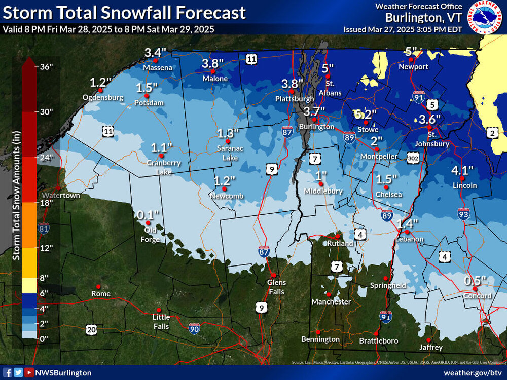
There hasn’t been much change to the BTV NWS advisories map, but the Event Total Snowfall map has seen some adjustments with their latest update. There’s an expansion of the areas with 6-8” shading in Northern Vermont, and now some 8-12” coloring is appearing along the eastern slopes in the Stowe/Smugg’s area. In general, the snow accumulation zones were extended a bit farther south, presumably based on changes seen in more recent modeling runs. In our area, the point forecast for snow has been bumped to roughly the 4-8” range, which seems consistent with the updated map. The BTV NWS forecast discussion clearly notes how difficult it is to pin down specific snowfall amounts with how tight the gradient is along the front, so they’ll just have to keep watching the guidance and we’ll get their latest thoughts in the next update.
-
This afternoon I received an alert that we’d been put under a Winter Weather Advisory for the storm expected to affect the area tomorrow night into the weekend. The BTV NWS forecast discussion indicates that the highest totals look to be across parts of Northern Vermont, where 3 to 7 inches and locally higher totals are expected, but the frontal boundary is sharp, and snow totals are highly dependent on where that front sets up. In any event, the Storm Total Snowfall Forecast Map has areas of 4-6” and 6-8” shading around the Northern Greens, which seems to line up fairly well with the discussion. At our site in the Winooski Valley, our NWS point forecast suggests snow accumulations in the 2-4” or 3-5” range. Most of the weather modeling suggests total liquid equivalent from the system in the range of 1 to 2 inches, so it could represent a solid resurfacing for the slopes where the precipitation stays mostly snow, or even sleet. The latest BTV NWS maps are below.
-
Similar to both December and January this season, March has had an interesting mid-month lull in snowfall. The first 10 days of the month saw six systems come through the area under what I’d describe as a March-style bread and butter pattern here in the Northern Greens. That stretch produced more than a foot of snow down at our site in the Winooski Valley. Then, the middle 10 days of the month brought some warm spring-like temperatures to set up great corn snow skiing. But like clockwork, as soon as we hit the 20th and got into the last third of the month, Mother Nature decided it was time to get back to winter and it started to snow again. We’ve been gradually working our way back into another bread-and-butter pattern of systems, with 3 storms passing through the area so far, and the potential for another 3 to 4 systems shown in the modeling through the end of the month. With the current pattern, the rounds of snow that have been hitting the area delivered accumulations in relatively modest doses that hadn’t had a chance to resurface the temperature-cycled spring snowpack, but this latest system decided to kick it up a notch. When I saw Powderfreak’s report yesterday evening of 4 to 5 inches of new snow on Mt. Mansfield, it piqued my interest. Later that night when we started to get huge flakes all the way to the valley bottoms bringing moderate to heavy snowfall, I knew it was time to prep the skis for some morning turns. Powderfreak’s report from this morning confirmed that Stowe had indeed received a healthy shot of powder, and as of this afternoon, Mt. Mansfield’s snow total since yesterday morning was over a foot. Bolton Valley seemed a bit slow updating some versions of their snow report this morning, but it looked like they’d picked up 4 to 5 inches of new snow overnight. In our area of the valley, we’d also picked up a couple inches of new snow from this latest system, so those numbers made sense for the elevations. There seemed to be substantial elevation dependence with respect to the snowfall though, and indeed, the lower elevations of the Bolton Valley Access Road didn’t even have a trace of snow as I began the ascent this morning. It wasn’t until I hit about 1,000’ that I saw any of the new snow at all. With that in mind, I cruised right past Timberline and headed up to Bolton’s main base to use the Wilderness Uphill Route for today’s ski tour. Powder depths at 2,000’ were 4 to 5 inches, and 6 to 7 inches where I topped out around 2,700’ The snow seemed fluffy on my ascent, so I was wondering if it the new accumulations were going to be substantial enough to keep me off the spring base, but the snow ended up being way more buoyant than I’d thought it would be. On mid-fat skis, I was able to get roughly 95% bottomless turns on low to moderate-angle terrain, so the powder skiing ended up being great. Getting out in the morning was definitely the play in terms of hitting the powder though, because I could tell that the temperatures were starting to rise above freezing as I was finishing my tour. Here’s the elevation profile for new snow depths above the old base from today’s observations in the Bolton Valley area: 340’: 0” 500’: 0” 1,000’: 0-1” 1,200’: 1” 1,500’: 2” 2,000’: 4-5” 2,500’: 5-6” 2,700’: 6-7” Overall, it’s felt like a busy season at the resort. I’m sure one factor in the number of people coming up to the mountain has been the consistently good conditions we’ve had thanks to the lack of any large, warm systems during the heart of winter. You can tell we’re into March now though, at least with respect to the number of cars that were in the Village parking lots this morning in the first hour or so of lift operations. Even though it was a decent powder day, tiers 1 and 2 of the Village lots were only about half filled. Indeed, it’s a weekday, but that’s definitely far less than what I was seeing on equivalent days just a few weeks back. As noted, the weather modeling suggests there are a number of wintry systems in the pipeline in the near future, and that potential keeps going well into April. But as is typical this time of year, the temperatures may be marginal with some of the events, so elevation will be helpful. With the mid-month warm stretch we had, the snowpack at the Mt. Mansfield stake dropped down a bit from where it peaked at over 100 inches, but it’s at 90 inches today after these recent snows, so there’s a lot of liquid equivalent in there to support plenty of turns in the coming weeks.

-
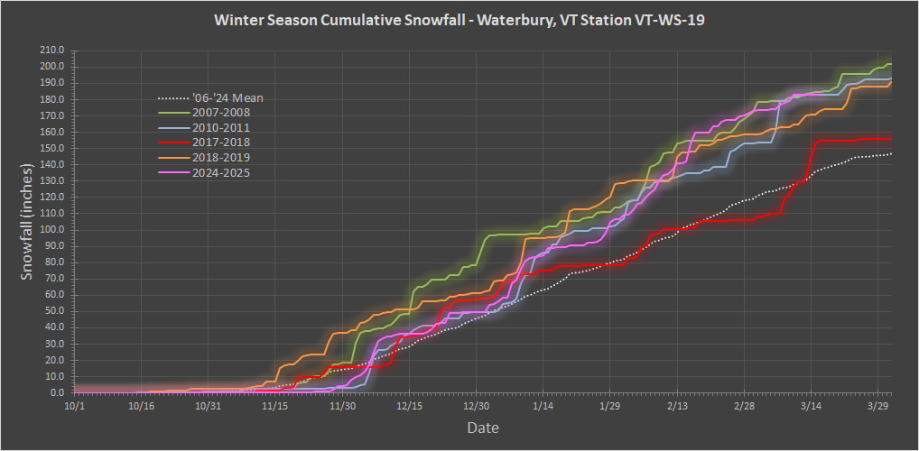
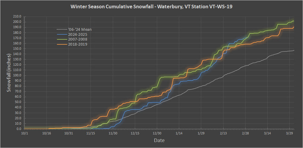
Total snowfall for 2017-2018 was 167.2”, so just a bit above average. I added it to the plot as the red trace below, and you can see that at this point in the season it was not up in the cluster of these seasons on the higher end of totals.
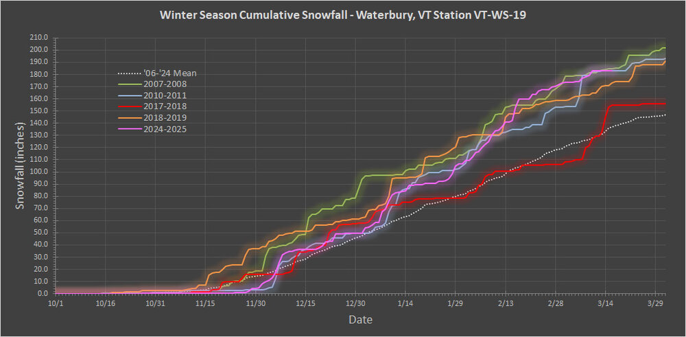
-
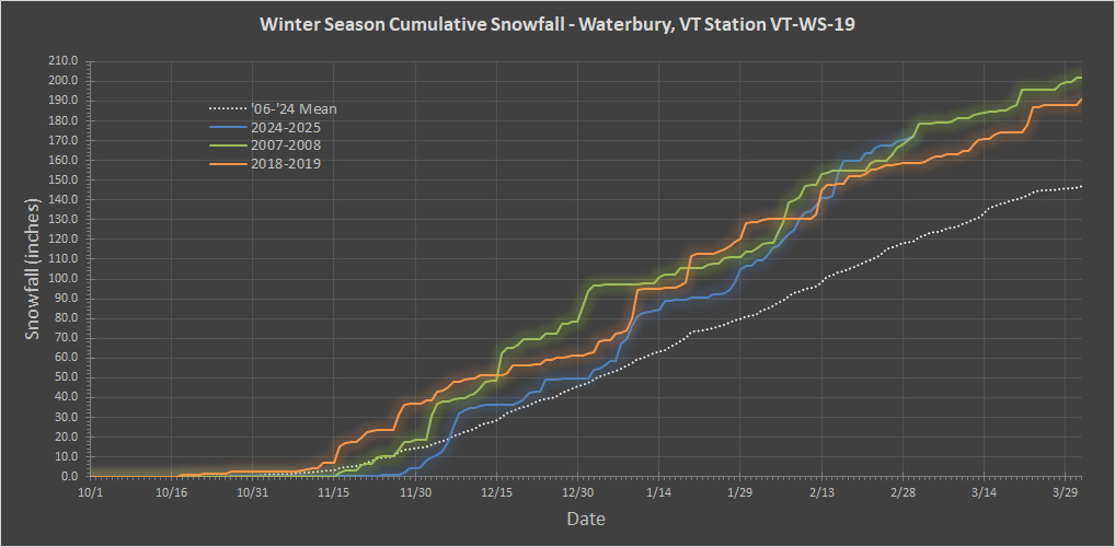
Thanks for the update PF. That lavender blue coloring demarcation for 120”+ really makes the Northern Greens stand out and reveals how snowy some of the lower elevation sites are around here. Since snowfall routinely starts up in October/November in our area, I don’t generally think about the “meteorological winter” block of time in isolation, but your post prompted me to check my data. It looks like this season actually had the highest snowfall for that period on my records. As I mentioned earlier, December, January, and February all ran above average on snowfall, and that doesn’t happen too often. The current season isn’t in first place on overall snowfall at the moment because of the relatively slow November for the lower elevations, but if we’d had even a roughly average November, we’d be around 200” of snowfall already and it would certainly be in the lead. It’s just not easy to pull off month after month after month after month of above average snowfall, which is of course why the overall averages are what they are. In any event, it’s mid-month and a good time to check in on the season’s snowfall progression, so the updated plot has been added below. For some reason, people hadn’t mentioned the 2010-2011 winter season in the discussion yet (I guess it was a little behind the others back in February), but it’s clearly in the same range as these other seasons that are part of the conversation, so I’ve added it to the snowfall progression plot as a light blue trace. As far as this season’s snowfall progress is concerned, we haven’t had any new snow since Monday’s storm, so one can see the current plateau shown in pink in the plot. This stretch over the past several days has actually been a relatively long period to go without any new snow – a quick look at the plot shows that the last time we’d had a stretch like this was back at the end of December. But as we get toward March and temperatures begin to rise, that’s not too surprising. I know you’ve mentioned that the season has been “decent” and “respectable”, and based on snowfall, I’d probably go with something a bit stronger like “solid” or something along those lines. The current snowfall progression plot clearly speaks to the fact that the season isn’t off the charts special or anything like that though. Even in my 18 years of data there were three seasons with similar snowfall at this point, and now this makes a fourth one of these types of seasons in less that 20 years. So, being at this amount of season snowfall in mid-March isn’t uncommon, and my records suggest that we’re typically in this position every 4 to 5 seasons. I guess another way to put it would be that based on what we’ve seen up to this point, it would put 2024-2025 in the top 20-25% of seasons for this area based on snowfall. A feather in the cap of this season that should be noted was the many weeks through January and February in which we didn’t have a single major thaw, and that obviously helped with snow quality and snowpack building, but it’s not as if we haven’t had similar stretches like that before. An argument for a knock against this season that could be made was the lack of large storms – we didn’t have any of those 40 to 60-inch storm cycles that sometimes hit the local mountains. Those events often arise from having a large system pass along the coast and then park itself up near the Maritimes, but there just weren’t any huge coastal systems to easily set that up this season. Those storms can be nice, but the amplified patterns that often promote them can be more trouble than they’re worth. If you have an amplified pattern creating huge storms, and even one of those passes to the west of the area, the warmth it brings can be quite detrimental to the snowpack and snow conditions. A more zonal “bread and butter” type of flow is a much steadier, safer approach toward snow quality and good skiing, and as this season has shown, the Northern Greens can clearly succeed with decent snowfall and snowpack in a season like that. If climate change really is reducing amplification and promoting more zonal flow like some say, then maybe snowfall averages around here will start climbing like people have suggested. It’s hard to imagine that the Great Lakes would be spending more time cold/frozen if temperatures continue to rise, so that moisture source is going to be more readily available, and the local mountains/orographics aren’t going anywhere as far as we know. If the type of winter we’ve been having this season is what the local resorts up here in the Northern Greens have to deal with more frequently going forward, I don’t think many of them will complain about the potential lack of a few of those upper echelon storm cycles. Those really big events certainly do provide a fun jolt to the excitement level in the local ski scene, and they can provide some off the hook powder conditions in the short term, so that’s a downside of missing out on them. In any event, there’s still 2 to 3 months of potential snowfall to go for this season, and it looks like snow chances are going to pick back up this week based on the modeling and forecasts: Area Forecast Discussion National Weather Service Burlington VT 139 PM EDT Sun Mar 16 2025 LONG TERM /TUESDAY NIGHT THROUGH SUNDAY/... Temperatures drop to seasonable levels behind this system and this colder pattern looks to remain into the start of next week. So, we’ll see where the numbers go from here.

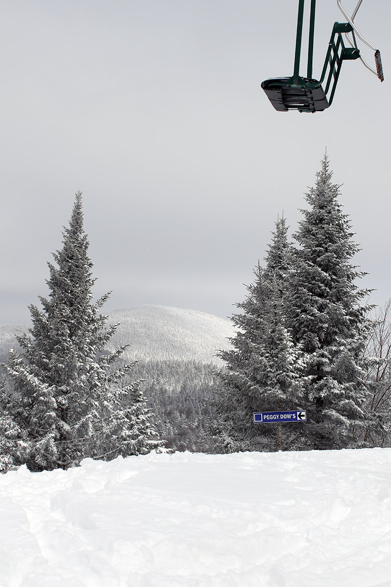
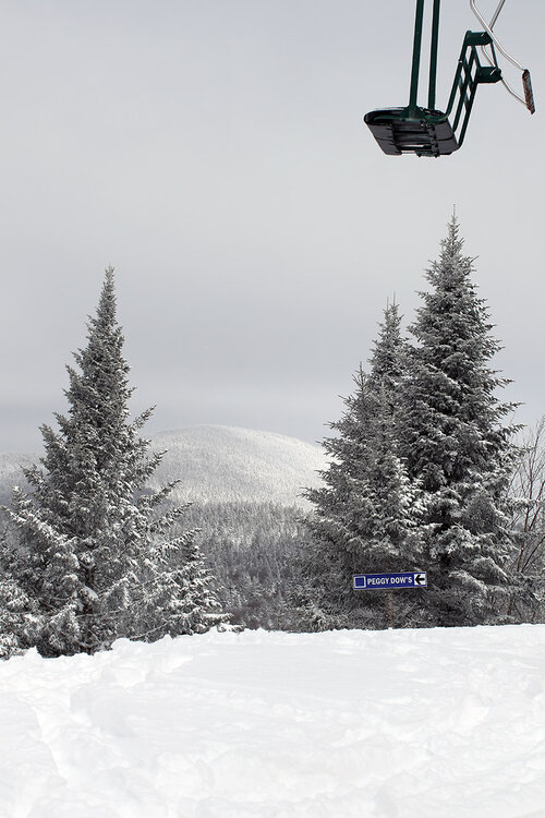
-
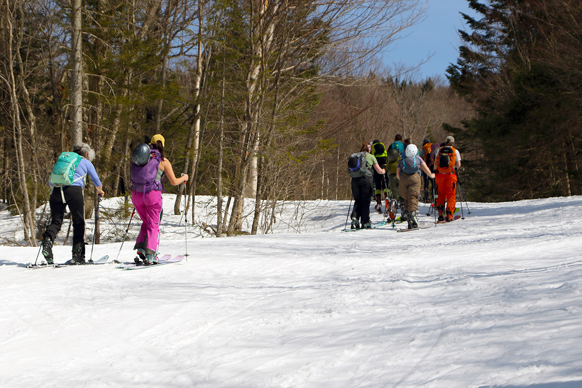
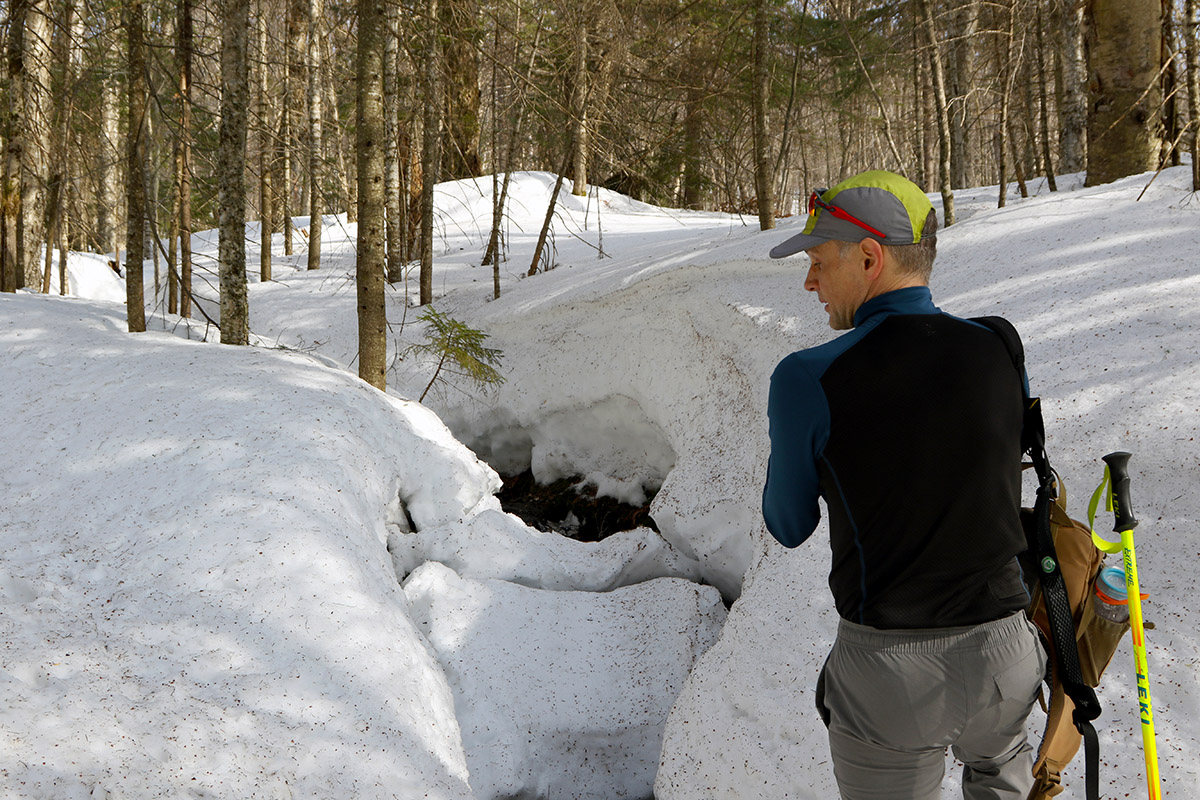
Spring was in full effect today, with temperatures up into the 50s F even at elevation. My wife figured it would be a great day to head up to the mountain for some spring skiing, so the two of us hit the mountain around noontime. We’d hoped to park at Timberline, but the first day of the Blauvelt’s Banks competition was taking place there, and there wasn’t a spot to be found. So, we continued on up to the main base and parking was getting maxed out there as well. Fortunately, they were allowing people to park right on the Bolton Valley Access Road, and we had some lucky timing that got us a spot right by the Village Circle for incredibly easy access to the lifts. Also taking place today was “A Day for Jake” to celebrate the legacy of Jake Burton, and Bolton Valley was one of the participating resorts, with various activities throughout the day. With so much going on, and a simply spectacular warm spring day offering full sunshine, it wasn’t a surprise that the parking was filling up. Despite the large number of visitors to the resort, the only chair with any sort of lift queue was the Vista Quad, and that was just a few minutes. The other lifts were simply walk-on, and we found that curious at first, but after our first run on Wilderness, we discovered why. With the warm temperatures, the terrain offerings from Vista were far and away the best ski options. Steep, natural snow terrain faces just below the summit ridge level that have been plagued by the strong westerly winds this season have never had much snow on them, and they’ve already begun to melt out. This meant that Peggy Dow’s was really the only main route off the Wilderness Summit. On top of that, natural snow terrain without high-angle pitches was getting slow in the afternoon sun – you had to stick to the shady sides of the trials to get the best glide. Steep terrain with manmade snow was the very best place to be for turns today, and Vista certainly has that. People had clearly figured that out, and it’s why everyone flocked to the Vista Quad. Turns were excellent on the steep slopes of Spillway and Hard Luck, which can often be overly firm with their hard, manmade surfaces. That certainly wasn’t the case today though; that firm manmade snow was setting up very nicely with the warm afternoon sun to make some excellent spring snow surfaces. After my wife and I were done with our ski session, she headed home and I was able to hook up with my colleagues Mark and Dustin, who were out for some snowshoeing on the Bolton’s Nordic and Backcountry Network. They spent some time touring on World Cup, then when I joined them we took a trip up to Bryant Cabin and back via the Bryant Trail. We were able to chat, talk some shop, and really just enjoy more of a great spring day in the mountains. Mark and Dustin were very impressed with the depth of the snowpack. You really couldn’t tell how deep the snow was when you were walking on it, but occasionally at a stream crossing you’d get a view of where water had cut into the snowpack, and you could get a serious perspective on the depth. The snowpack at the Mt. Mansfield Stake is currently in the range of 7 to 8 feet, so there’s definitely a lot of base in place as we head farther into the spring skiing season.


-
With yesterday’s new snow, my plan had always been to head up to the mountain for some turns as soon as I’d taken care of a scheduled meeting in the morning. Unsure of how the temperatures were going to affect the powder later in the day though, I’d gone out for an early morning ski tour via the Wilderness Uphill Route. A colleague of mine is in town for a couple of weeks working on a project, and he was eager to get up to the mountain for some Nordic skiing when he heard about all the new snow, so the two of us headed back to Bolton Valley for a midday session. For the afternoon session, I was thinking of either going for another tour, or doing some lift-served skiing, but I first wanted to see how the quality of the powder was faring as we approached midday. While swinging through the Village Circle to let my colleague pick up his Nordic pass, the temperature was just below freezing at the 2,000’ elevation, so I figured riding the lifts was the safer bet in case the snow started to get wet. We parked right along the Broadway Trail in the backcountry lot, and it provided perfect access for my colleague to jump onto the trail network for his Nordic session, while I headed up to the Vista Quad. Though the temperature may have been approaching the freezing mark at 2,000’, it was well down into the 20s F once you got up around 3,000’. I’d wondered if there was going to be some warmer air at elevation, but that question had been quickly answered. The powder I found was just as good as what I’d experienced in the morning, and there had obviously been some lift-served skier traffic, but being a midweek day, there was still plenty of untracked snow to ski. I started off on Spillway Lane, and the typically snow areas off to the left were providing excellent powder turns. When I dropped into Hard Luck though, I quickly realized that it was too steep for the available snow – it was tracked up enough that I was hitting the subsurface constantly, and that subsurface is fairly firm. As soon as I discovered this, I cut to the right into some trees and made my way onto Vermont 200. What I found was that at those black diamond pitches, you really needed first tracks to get soft, bottomless turns. Once a few tracks were in place, you started to hit the subsurface. Thankfully, the bottom sections of Vermont 200 where the terrain spreads out provided plenty of untouched snow for excellent turns. After that first run though, I spent the rest of my session focused on more moderate angle terrain, and that provided consistently great turns. With time, the snow started to get a bit denser down toward the Village, and the powder was still skiing well, but you could tell the freezing level was rising. When I’d finished my session and was waiting at the car for my colleague to finish up, I was able to soak up some sun really appreciate the weather that we were getting. After what’s been a long, consistently cold winter season, it was finally starting to feel like March!


-
Since Winter Storm Lola last week, we’ve had sort of a miniature Northern Greens bread-and-butter pattern of storms. We’ve had five winter systems affect the area in the past five days, bringing a foot of snow to our site in the valley, and substantially more to the local mountains. The two most recent weather events affected the area within hours of each other, with an area of upper-level vorticity affecting the area during the midday period yesterday, and quick moving Alberta Clipper system hitting the area during the overnight period. When I looked outside last night around midnight and saw heavy snow falling with flakes up to 20 mm in diameter, it was a sign that I should get the ski gear ready. As of this morning we’d picked up 4.8 inches of new snow at the house, and the Bolton Valley snow report was indicating 6 to 8 inches of snow in the past 24 hours, so a trip up to the hill was definitely in order. My time was somewhat limited in the early morning, but with the potential for temperatures to rise above freezing later in the day, I still wanted to get in a quick ski tour in the fresh snow. I toured via the Wilderness Uphill Route on the lower half of the main mountain in the 2,000’ to 2,300’ elevation range and found powder depths of 7 to 10 inches over the subsurface. It was medium weight powder and easily set up bottomless turns on lower and mid-angle slopes. Temperatures were in the mid-20s F, which was comfortable yet cool enough to keep the powder in excellent shape.
-
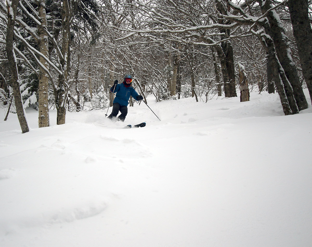
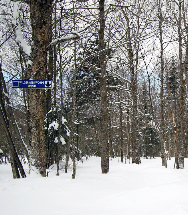
I really hadn’t planned on skiing today. Earlier in the week, Winter Storm Lola came through the area, and it was a warm enough system at all elevations that conditions were clearly going to firm up after it passed and temperatures cooled back down. While we did get some snow on the front and back ends of the system, it wasn’t going to be enough to get anywhere near the resurfacing that would be needed to soften up the ski surfaces. I was somewhat looking forward to an excuse to not head up to the mountain though; the snow conditions have been so good for more than two months straight that it’s been hard to pull away from the snow to catch up on everything else in life. Today I figured I’d take the opportunity to head on in to work and get some things done there. Mother Nature seemed to have other plans for me though. While there weren’t any major winter storms in the area, this is Northern Vermont, and sometimes snow, heavy snow, just happens. As I was driving home from Burlington yesterday afternoon, I did so to the tune of some very heavy snowfall. It wasn’t that the roads themselves were too bad in terms of traction, since there was only an inch or two of new snow on them; it was the visibility that was an issue. It was 1-2”/hr. snowfall with big flakes, and the plows hadn’t been out clearing things off yet. So, it was just white on white on white with massive flakes pounding down so that you could only see about a car’s length in front of you. Forget about trying to tell where the edge of the road or the other lane was. I couldn’t believe that I hadn’t received a squall alert on my phone with how difficult the driving was, but I did find out that at least there were Special Weather Statements posted: NEAR TERM /THROUGH SATURDAY NIGHT/... As of 645 PM EST Friday...Main focus with the update this evening was to monitor the ongoing heavy, gusty showers stretched across the forecast area. Have issued Special Weather Statements over the past few hours to note this, however these showers are not quite reaching true snow squall criteria with visibilities floating around 1/4 to 1/2 but wind gusts barely cresting 30 mph at times. The concern comes in regards to folks still traveling for an evening commute. PoPs have been increased and weather type switched to heavy snow for the next several hours. I was definitely in the target audience for that message though, and it was essentially heavy snow for my entire drive home. I’ve never appreciated every little road reflector and sign that the highway department has in place along Route 2. Thankfully we don’t have those massive open areas of terrain like they do in the plains, but you can clearly see why they sometimes close down the highways out there. Later in the evening I was reading the BTV NWS forecast discussion, to catch up on what had hit the area earlier, and I then learned that apparently more snow was on the way: Once the Sun sets, winds should begin to decrease, and temperatures will gradually cool off into the teens to lower 20s again. That surface trough will produce additional snow showers overnight, which will be enhanced by an incoming upper vort and then push south by morning. Sure enough, the radar showed more snow upstream just about to hit the area, and I couldn’t help but wonder what things were going to look like in the morning. By early this morning, we’d picked up 3.2” of new snow down at our site in the valley, and Bolton Valley was reporting 3-5” new in their snow report. For better or worse, I knew that was going to be enough to get at least some of the lower angle terrain skiing quite well, so I packed my gear for a quick ski tour on my way into Burlington. Based on the accumulations, I knew the Wilderness Uphill Route would be the place to go, and this was only reinforced by the fact that neither the Wilderness Double Chair nor the Vista Quad Chair were running because of the strong winds that were hitting the mountains. Indeed, when I reached the Bolton Valley Village, the winds were howling. I was amazed at the number of visitors that were at the resort without two main lifts in operation – cars were parking in the third and fourth tiers of the Village parking lots. Temperatures were well up into the teens F though, and you can really feel that we’re not in January anymore. It was clear that the winds had been strong for a while, because even the very sheltered Lower Turnpike area had been hit. Between areas that had been groomed, and areas exposed to the winds, you really had to head off the edges of the trail to get into the powder. Once you got to that new snow though, it was there just like the snow report had said. Starting right from the 2,000’ elevation, I found about 4” of powder in protected areas off the trail, and I was able to find a general 3-6” of powder in the 2,000’ to 2,500’ elevation range where I toured. In areas with some drifting, I was finding up to 12” of new snow, but that was certainly not the norm. The skiing was excellent, as long as you knew where to go. The lower angle trees were definitely the ticket this morning – the powder in there had not been hit by the winds, and they probably collected the extra snow that had blow from the exposed areas on the trails. It was medium-weight powder, so certainly not enough to be bottomless, but on mid-fat skis it was enough to generally keep you out of contact with the subsurface for nice, quiet turns. The Lower Wilderness Woods area was very good in this regard, and it was made better by that fact that the snow was pristine. Yes, the summit lifts were down, but very few people were even out touring, and nobody had been in there. The turns were nice enough that I contemplated going for another run, and I definitely would have if I didn’t have anything else on my schedule for the day. It was especially tough to pull away from the mountain at that point because another round of heavy snowfall had moved in as I was finishing up my tour. It was quickly accumulating over everyone’s cars, and you knew it was going to beef up the powder another notch to further improve the skiing.


-
I was driving home from Burlington during that, and it was brutal. It wasn’t that the roads themselves were too bad in terms of traction, since there was only and inch or two of new snow on them; it was the visibility that was an issue. It was 1-2”/hr. snowfall with big flakes, and the plows weren’t really out clearing things off yet. So, it was just white on white on white with massive flakes pounding down so that you can only see about a car’s length in front of you. Forget about trying to tell where the edge of the road or the other lane was. I couldn’t believe that I hadn’t received a squall alert on my phone with how difficult the driving was, but at least there were Special Weather Statements: NEAR TERM /THROUGH SATURDAY NIGHT/... As of 645 PM EST Friday...Main focus with the update this evening was to monitor the ongoing heavy, gusty showers stretched across the forecast area. Have issued Special Weather Statements over the past few hours to note this, however these showers are not quite reaching true snow squall criteria with visibilities floating around 1/4 to 1/2 but wind gusts barely cresting 30 mph at times. The concern comes in regards to folks still traveling for an evening commute. PoPs have been increased and weather type switched to heavy snow for the next several hours. I was definitely in the target audience for that message though, and it was essentially heavy snow for my entire drive home. I’ve never appreciated every little road reflector and sign that the highway department has in place along Route 2. Thankfully we don’t have those massive open areas of terrain like they do in the plains, but you can clearly see why they sometimes close down the highways out there. I was reading the BTV NWS forecast discussion, and it was only there that I learned that apparently more snow is on the way tonight: Once the Sun sets, winds should begin to decrease and temperatures will gradually cool off into the teens to lower 20s again. That surface trough will produce additional snow showers overnight, which will be enhanced by an incoming upper vort and then push south by morning. Sure enough, the radar shows more snow upstream just about to hit the area. Life in the Northern Greens.
-
I don’t know the resort numbers for Stowe, but here in the Winooski Valley we had 2.74” liquid equivalent and 59.5” of snow for January (2.51” of liquid equivalent for the Jan 2-31 period you mentioned). Mean liquid equivalent for January here at our site is 3.45 ± 1.28”, so this January was below average, but well within 1 σ. Typically I find that the resorts in the Northern Greens run about 2X the snow (and presumably liquid) that our site sees, so that would be around 5 to 6 inches of liquid equivalent for the mountains this past January. The 2X snowfall number is very rough of course, but so far this season, Jay Peak is running at 2.25X our snowfall here in the Winooski Valley, and Bolton Valley is running at 1.81X our snowfall, and the average of those two is 2.03X. Bolton Valley is just a few miles away and our closest direct comparison for a resort elevation, and I think they’re running below the 2X ratio a bit because we’ve probably had fewer marginal temperature/elevation-dependent events this year relative to average.
-
Powderfreak should be able to give you the Froude Numbers that he typically associates with west/on/east of the spine, but your understanding of blocked vs unblocked flow is correct. For the Northern Greens ski resorts, Bolton Valley and Smuggler’s Notch are typically considered to be on the west side of the spine, while Stowe and Jay Peak are on the east side. As for the back side of the system at the end of the week (it’s been given the name Winter Storm Lola), there does appear to be some upslope snow potential. There’s not as much mention in the BTV NWS forecast discussions today, but they talked about the potential for several inches of snow yesterday: LONG TERM /WEDNESDAY THROUGH SUNDAY/... As of 326 AM EST Sunday… Post cold front passage Thursday night into Friday, several inches of upslope snow looks very possible, especially across the higher terrain of the northern Greens and Adirondacks as the region will remain under broad cyclonic northwest flow. Additional chances for snow showers are possible Friday night into Saturday as well with seasonal temperatures in the teens for lows and 20s to 30s for highs. The potential amounts will probably ebb and flow over the next few days in the modeling, but the GFS has consistently shown the potential for 6 inches or so thanks to the cyclonic northwest flow. The BTV NWS will certainly mention it in forecast discussions later this week if that look persists.
-
Our latest clipper system began affecting the area last night, setting up some fresh accumulations in the mountains for today’s turns. Bolton Valley was reporting another 3 to 4 inches of new snow overnight to top off the snow from our other recent systems, and down at the house we’ve picked up 3 inches of snow from this system with a bit over ¼ inch of liquid equivalent. In terms of how the new accumulations played out on the mountain, you really wanted elevation to get to the best snow. Elevation mattered both in terms of the quality of the subsurface, as well as the depths and consistency of the powder above it. We found that conditions were fine as long as you were above ~2,000’, so although we parked down at 1,500’ at Timberline, we spent most of our session up at the main mountain. Up above 3,000’ it was easy to find powder depths in the 8 to 12-inch range above previously packed surfaces, and at 2,000’ I’d say depths on equivalent surfaces were more in the 4 to 6-inch range. That dropped down to just a couple inches at 1,500’, but just as important was that the subsurface snow became wetter down below 2,000’. Based on what I’d experienced on my ski tour yesterday, where I found multiple layers in the surface snow of varying densities, we went with alpine skis today instead of Telemark skis, and that really seemed to be the right call. It didn’t matter much in the highest elevations where the powder was deeper, it was of lower density, and thicker layers in it were less pronounced, but the lower one went in elevation, the more having that stable platform of alpine skis helped in the off-piste areas. You really could get some nice turns at most elevations, but the main mountain delivered the best powder. Temperatures were very comfortable today – they must have been right around the freezing mark when we arrived at Timberline in the morning, and probably in the mid-20s F up in the summit areas. We’re at the end of the current winter vacation week for schools, so being a Saturday with fresh snow and good temperatures, it was busy at the resort. When we headed back down to Timberline around midday, it seemed like even the Timberline parking areas were filling up, and people were having to hunt around for spots. Both in the mountains and the valleys, it really started to pound snow in the afternoon with huge flakes as the back half of the Clipper began to push through. With this system, Bolton hit the 300” mark on the season’s snowfall, so they’re quickly approaching their season average with all of March and April still to go.


-
We’ve reached March 1st, so it’s a good time for a check on the season’s snowfall progression at our site. February was another solid month for snowfall, with 60+ inches to add to the totals. The train of winter storms has been keeping this season’s snowfall progression right up there with the 2007-2008 season as the cumulative snowfall chart shows below. In the 2007-2008 season we were in the midst of a double-digit storm on this date though, so it’s going to be tough for the current season to keep pace with that in the short term. We’ll have to see how much more we pick up on the back side of the current system, but even down here in the valley we’ve been getting hit with heavy snowfall made up of huge flakes this afternoon. As it stands right now, 2024-2025 certainly has the chance to be another 200”+ winter down here in the valley; there are 2 to 3 months left in the snowfall season, and simply getting average snowfall from here on out would hit the mark. In fact, even 80% of average snowfall from here on out would hit the mark, but we’ll just have to see what Mother Nature delivers.
-
I hadn’t been up to the mountain since Sunday, but temperatures have been on a bit of a roller coaster ride this week, and we’ve had some snowstorms come through the area as well, so I was curious to see what the conditions were like on the slopes. Since the weekend storm that was putting down snow when we were at Bolton Valley on Sunday, there was a midweek system that brought about a half foot of snow to the mountains, then a similar system that hit the area yesterday into today. There were also some warmer days during the week, and I’m not sure how high the freezing levels went, but up to a foot of snow in the past few days definitely had the potential to further enhance the ski surfaces. From the two systems, we picked up almost ¾ inch of liquid equivalent down in the valley, so the local mountains must have had an inch of liquid equivalent or more. Arriving at Bolton Valley between 9:00 and 10:00 A.M., I was surprised to find that people were already parking in the third tier of the Village lots, but then I remembered that this is also a big school vacation week, just like last week was. I toured in the 2,000’ to 2,500’ range via the Wilderness Uphill Route, and there was definitely some elevation dependence with the recent snowfall accumulations. I typically found powder depths in the 4-6” range around 2,000’, but I was getting 6-10” readings up around 2,500’. It appeared that there was some mixed precipitation and/or melt crust in the layers of surface snow, depending on elevation. Those firmer layers were typically sandwiched between layers of lighter snow, but you could definitely feel them, and they had more of an effect in the areas with shallower depths of powder. I had to really be disciplined when making Telemark turns to avoid getting pushed around, but with alpine turns you could hardly tell there were any thicker snow layers present, and I bet if you were riding a board, it would be even smoother. Our next system is hitting us right now, and this one may be a bit more potent because I’ve seen snowfall forecasts as high as 8-12” for some higher elevations spots along the spine. Tomorrow has the potential to be a pretty decent day with the addition of this next round of snow atop the others that fell this week.
-
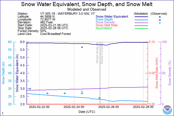
I cored our site’s snowpack yesterday for CoCoRaHS “SWE Monday”, since it also seemed like a good time to run an analysis ahead of some potential consolidation temperatures this week. The NOHRSC modeling for our site had the snowpack with a bit below 6 inches of total liquid equivalent in it, and indeed that wasn’t too far off from what I measured as the plot below shows. One can imagine how much water is up in the snowpack in the high country if we have half a foot at the bottom of the Winooski Valley at ~500’, and there may be more to add to it still in the coming weeks. Hopefully the melting process proceeds at a reasonable pace when the time comes.
-
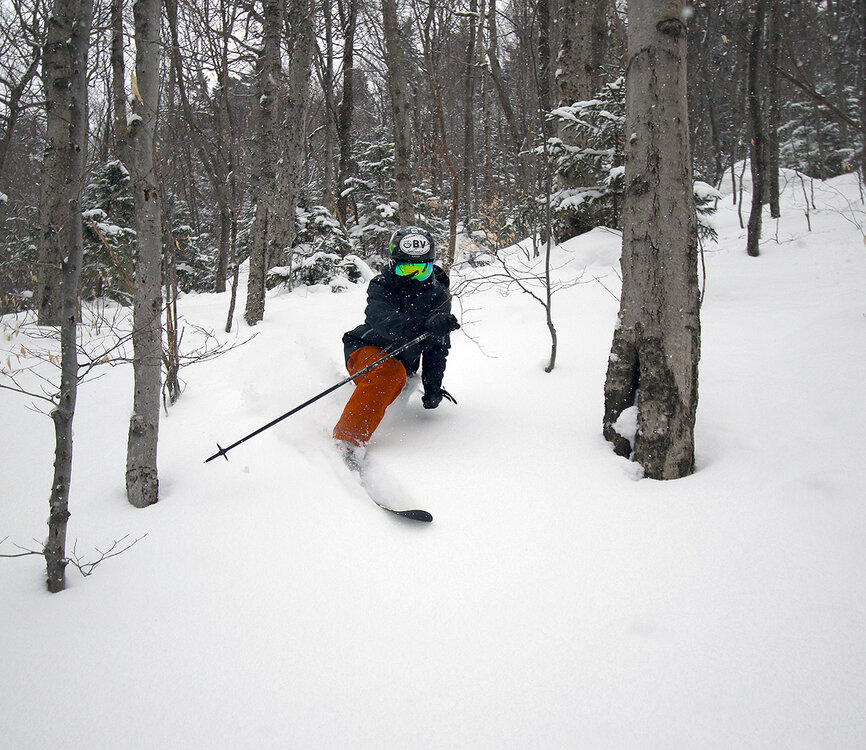
Saturday was a real gem of a winter day with sunshine and temperatures in the 20s F. Our next system moved into the area Saturday night and continued through the entire day Sunday, delivering another 4 inches of snow here in the valley, and 10 inches up on the mountain. The snow was steady by generally light in intensity, and the temperatures stayed right up in the 20s F, so Sunday was another great day to be on the mountain. I headed up to Bolton Valley in the afternoon with my wife and my older son, and we spent our time at Timberline just like I’d done on Saturday. While Saturday had been busier than normal, in part due to it being such a pleasant, sunny day, Sunday seemed much more typical, with no lift queues at the Timberline Quad. Twice as Nice and Spell Binder had some excellent natural snow conditions, which had been bolstered by the new snow from the ongoing storm. When my wife took a break in the lodge, my son and I headed out for a bit more powder exploration, with a long run in the Adam’s Solitude area. Even with the new snow, there had been a lot of traffic over the weekend in greater Adam’s Solitude area, so you had some hunting to do for untracked lines. We found that most other off piste areas had seen less traffic, and we had some nice lines in the KP Glades, but you can’t blame folks for hitting the Adam’s Solitude area – the snowpack is deep and this is the time of year to do it.