IWXwx
-
Posts
6,525 -
Joined
-
Last visited
Content Type
Profiles
Blogs
Forums
American Weather
Media Demo
Store
Gallery
Everything posted by IWXwx
-
I spent a lot of time outside today. “Give a man a shovel and he’ll clear the sidewalk. Give a man a snowblower and he’ll clear the neighborhood.” - My Wife
-
Yeah, I was just thinking the same thing about Bo and woah! His area is really sucking this year.
-
Nope, only GRR with a WWA. I don't know what IWX is waiting on. Maybe waiting to coordinate with LOT? There definitely should be a Watch out for heavy snow in the NW CWA and maybe a WWA for a mixed bag in the SE.
-
....and yet the deniers are still out there
-
Props to Alek for the continual thread title changes.
-
I spent last weekend in Indy where we got plain rain. I noticing ice on the drive north on Sunday afternoon in just about in your area.
-
Same here in FWA. I'll be waving as it slides by to the north. Time to put my $7.99 a dozen eggs in the Saturday/Sunday basket.
-
A tenth of an inch of glaze here. Lightning struck a house locally and it burned down last night.
-
IND broke their record, hitting 68. Huuuge overperformer
-
Even though the zr signal is there, I would think that the high off of the Atlantic coast on both the Euro and GFS would need to be positioned more to the northwest in Ontario to keep the feed of cold air coming. There might be some significant ice, but without a prolonged cold air feed, it will probably be short-lived. (I've always wanted to make a map )
-
There's a reason why I'm the one that usually starts the complaint thread. Pathetic.

-
Or stay under the record until mid-March, then get a wrist-slashing 10" of cement that melts the next day, making the seasonal snowfall not look that bad years down the road, when it fact it sucked badly.
-
I thought that argument was over several years ago.
-
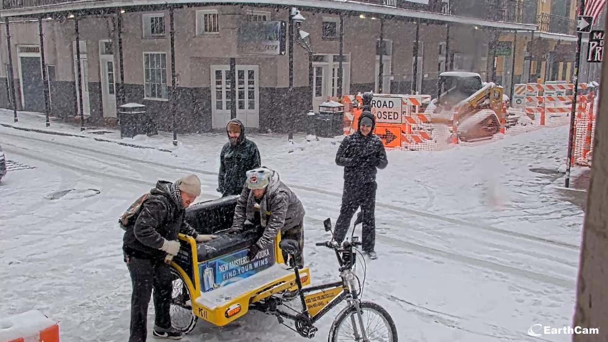
Bourbon Street right now

-
I reported to IWX the conditions as it rolled through here, thinking that they would issue a Snow Squall Warning, but only got a response of, "Thanks. That arctic front means business." Then they continued to issue SPS's downstream.
-
1.2" with the clipper this morning, then another 0.6" of +SN with the trailing arctic front this afternoon. Along with 1 1/2" already on the ground, it's gonna be white until at least Friday.
-
2.8" I'll take it and run with the way the past several winters have gone around here. Could get some freezing drizzle tomorrow to give the snow a glaze.
-
2.4” as of 7 PM (EST). Looking upstream, we could get another inch for a slight overperformer. I’m happy
-
I also laughed about that when I read it this morning, but we have less than inch down and roads are trashed. As usual, lots of wrecks and slide-offs, so it ended up being a good call, whether wanted to or not.
-
Yeah, things look to get really nasty out there. There already fires ongoing in the LA area.
-
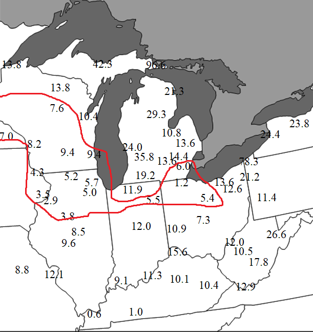
Cool map, but you didn't include Iowa or Minnesota, from which we have a lot of posters. Also, I modified it so that anyone inside the red line can post complaints, but I don't want to hear any bitching from those outside the line.
-
-
Uh...Yeah. That 1.0" southwest of FWA is my total depth. I actually only totaled 0.3" from the storm. The other 0.7" was from the previous system. That being said, it's nice that Southern IN cashed in. All hail King Euro
-
It's to the point where I just laugh about it now. We went from a Winter Storm Watch 36 hours ago to this: "A chance of flurries between 1am and 2am. Cloudy, with a low around 20. Northeast wind 10 to 15 mph, with gusts as high as 25 mph."
-
Glad to see you back Jack. I've had a couple of rounds of chemo and radiation for cancer, but am cancer free now. From radar it looks like you guys are both right on the edge of the sharp cutoff. In the meantime, we went from a WSW to an Advisory to a storm cancel. But we are having a virga storm. Oh, the humanity!!