TWCCraig
-
Posts
2,502 -
Joined
-
Last visited
Content Type
Profiles
Blogs
Forums
American Weather
Media Demo
Store
Gallery
Everything posted by TWCCraig
-
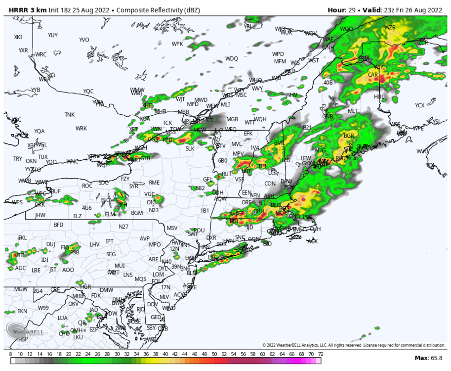
Can only hope the HRRR is on to something for tomorrow. Would certainly help bring some temporary relief
-
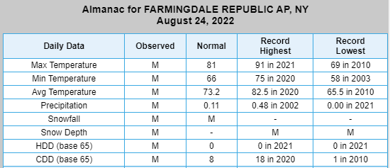
Oh ok, they must have not updated that site because it hit 91 on this day last year at FRG. But then again, FRG's period of record only starts in 1999
-
What site? ISP's record for today is 91 set in 1995
-

possible first significant rain in months for some 8/21-23
TWCCraig replied to forkyfork's topic in New York City Metro
The drought to me is pretty interesting. Almost a Mediterranean style summer. Only had 3 events since the beginning of July over 0.10" of precip. A nearby station recorded only 0.78" since July 1st. Consistent stable marine air on the south shore pretty much kills any chance, but it's usually not this bad. Globals are continuing the dry spell here. Must be a lot of sinking air on the western flank of the WAR. -
possible first significant rain in months for some 8/21-23
TWCCraig replied to forkyfork's topic in New York City Metro
0.00" here, not too far from you Maybe we can get some showers tonight or tomorrow. Not getting my hopes up though. -
Bust
-
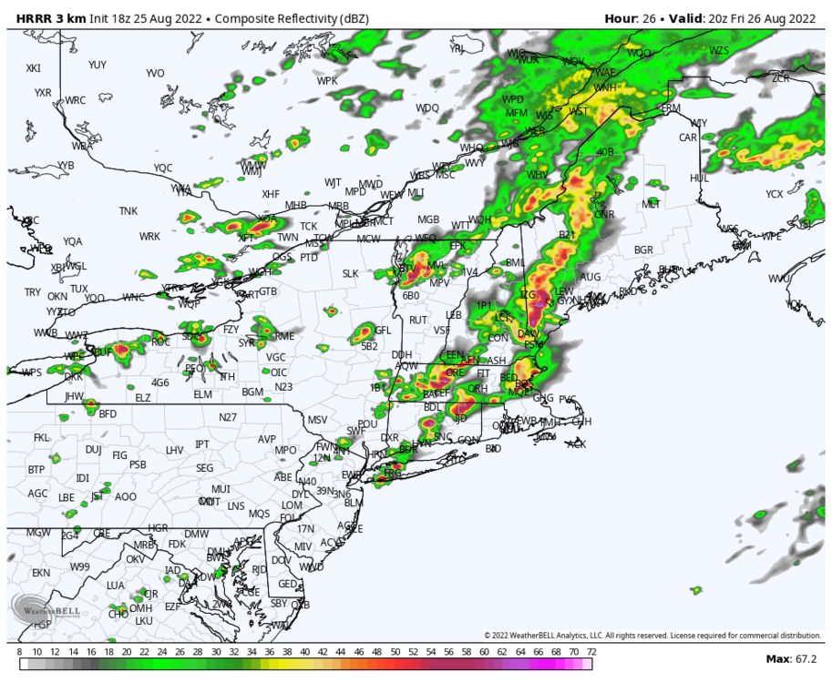
Models look pretty good for rain chances tomorrow. An area wide 0.5-1.0" is possible, however, convective precip can favor some areas more than other areas. Most models have at least 0.25" for the entire region. It's entirely possible some areas see a good amount of rain while some areas stay with lower amounts. Some areas could see a couple inches. Either way, the chances of rain are very high for tomorrow.
-
0.0" here, so far, might get a little rain in a bit. Easthampton picked up 0.74" of rain today and dropped to 59 degrees during the heaviest rain.
-
Huge difference in humidity levels across the area From Mesowest: NYC: 88/50 27%RH EWR: 90/54 30% RH LGA: 90/50 26% RH ISP: 82/70 66% RH
-
Some light rain this morning. Nothing to write home about but still plenty of time before we figure out what happens with the next system. Euro and GGEM were east with the heaviest rains, with the Canadian being very far east. GFS is the furthest west. We will see the models go back and fourth until we get a better picture downstream.
-
Don't have a working gauge but I'd estimate between 0.1-0.2", matches up with the radar. Gladly take over basically nothing the past several weeks. To speak of the greatness of the NAM, it doesn't have anyone in this forum hitting 80 degrees tomorrow lol
-
I'm just glad it's going to rain. I'll take anything. Going to pour any second now
-
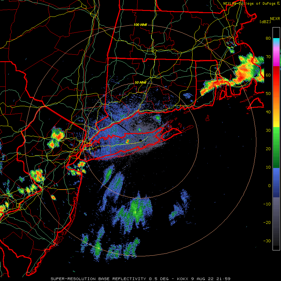
Decent small cell over north central Suffolk, fired up along the frontal boundary. Cell in NW NJ is heading towards the city

-
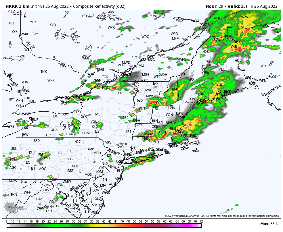
HRRR has consistently, since 0z run last night and almost every consecutive run, been showing cells firing over central Long Island during the evening hours tonight. It hasn't been too bad with the location of cells for today, it had the storms over the sound, north shore, CT and SE New England, so who knows if it will be right. Obviously, no model is perfect with convection like this. The front is pretty visible on OKX, still over CT. Storms are still building off of it. Interested to see what happens when it hits the sea breeze boundary.
-
Cool down for this upcoming weekend and then slowly fading back into an above normal pattern. Euro weeklies continue the above normal pattern into September through the end of its run
-
Same here. 88.3 was the warmest. Most days are maxing out between 86-88. Strong southerly sea breeze here keeping us from hitting 90. I'm only about 2 and a half miles from the water
-
Our air temperatures may be a bit cooler out here and we may have a stronger breeze, but we make up for it with the higher humidity and dew points. Places that are hotter usually have more drier air mixing down. I'm at 86.5/76.8 ... temp/dewpoint
-
87/77 Strong sea breeze here, slowly dropping temps, maxed out at 87.8 at 1:15pm
-
There's chances of rain later this week Wednesday and Thursday but I don't think it will be enough to put a dent in the drought IMO. I do think the chances for rain events will only increase as we head later into the season but nothing too promising. At this point I'd welcome a tropical system just to get the rain here, just one that's not super destructive.
-
We had a decent breeze pick up in the afternoon. We we're modeled to be upper 80's to low 90's with the warmest spots being the farthest away from the ocean breeze.
-
Only made it to 88, down to 85 now and falling faster
-
Drier air beginning to mix down from the NW towards the coast. JFK is at 89 degrees, dew point 65. They might have hit 90 after 8pm, which is pretty insane given no incoming solar radiation.
-
86 for a high here 88 at ISP 89 in the concrete jungle of Central Park
-
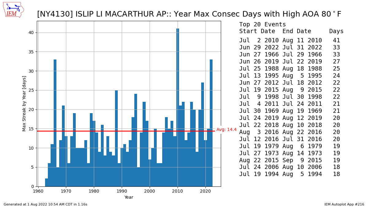
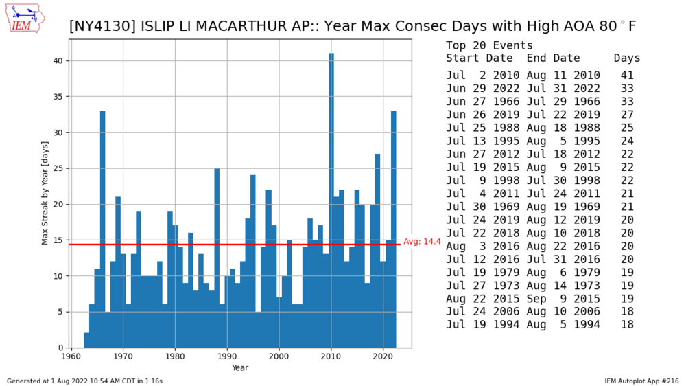
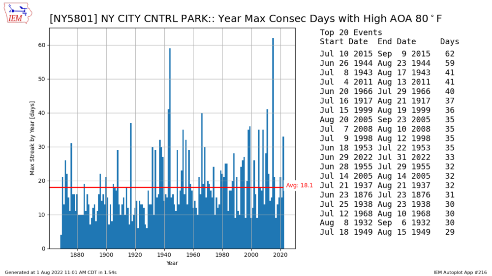
If today fails to hit 80, which it might, it will conclude ISP's second longest stretch of high temps above 80°F, tying 1966. 2010 had the longest stretch. Records go back only to 1963 Here is the same plot for NYC (Central Park)
-
Less than a quarter inch here. Not really enough to put a dent in the deficit. We need a real deluge to get us somewhere. The drought on the south shore continues, and will continue.