

mitchnick
-
Posts
28,735 -
Joined
Content Type
Profiles
Blogs
Forums
American Weather
Media Demo
Store
Gallery
Everything posted by mitchnick
-
Those thinking AN precip must be on X because I see nothing to suggest that in this thread and Niñas are notoriously dry in the I95 corridor in the MA & SE. I don't claim to know climo NYC on north and east, but that area seems to get additional juice from Miller B's we miss down here, but I don't know which area (s) you meant.
-
At 500mb, that blend looks pretty darn close to what seasonal modeling is showing. Barring something extraordinary, I think that's a fair guess with hopes it busts cooler. That said, I'm sorry not to see 20/21 as part of your thinking solely for maintaining a weenie dream. Thanks for the Outlook and good luck with the job search.
-
Central PA Autumn 2024
mitchnick replied to Itstrainingtime's topic in Upstate New York/Pennsylvania
44 looks to be lowest around here. -
Updated NMME average for Dec-Feb has most of us at +1-1.5C, which those of us winter lovers would take (a little cooler east of I95 from Wilmington North and east.) It's arguably a touch cooler in that the +1.5-2C line has retreated pretty far south vs the last run, but that's splitting hairs. https://www.tropicaltidbits.com/analysis/models/?model=nmme®ion=us&pkg=T2maMean_month_nmme&runtime=2024100800&fh=4 EDIT: Normal precip for most of us along the eastern seaboard.
-
Central PA Autumn 2024
mitchnick replied to Itstrainingtime's topic in Upstate New York/Pennsylvania
.10" from last night -
Central PA Autumn 2024
mitchnick replied to Itstrainingtime's topic in Upstate New York/Pennsylvania
192hrs from 6z on 9/30. -
Central PA Autumn 2024
mitchnick replied to Itstrainingtime's topic in Upstate New York/Pennsylvania
Gfs first version before losing it was a Helene type track. -
For what little it's worth, Cfs2 continues to cool ever so slightly each day for the past couple of weeks. It's probably too aggressive, but seeing it go the "right" way delays the bubble from bursting another day! Lol
-
Central PA Autumn 2024
mitchnick replied to Itstrainingtime's topic in Upstate New York/Pennsylvania
I would think your side of the mts have the best chance tonight. Good luck. -
Central PA Autumn 2024
mitchnick replied to Itstrainingtime's topic in Upstate New York/Pennsylvania
My grass is still growing at a decent rate. I ended up with around 3.8" during that 10 day mushroom fest, so I'm fine with dry for the next week+. Summer's over so the hell with the grass! -
Central PA Autumn 2024
mitchnick replied to Itstrainingtime's topic in Upstate New York/Pennsylvania
Incoming https://weather.cod.edu/satrad/nexrad/?parms=CCX-N0B-1-24-100-usa-rad -
I never said I expect cold/snowy. In fact, I don't and would be just as surprised as you if we got one. I'm simply talking about a winter that offers potential for favorable periods, which is how it works down here. How much can fall during those periods is TBD by luck of both the exact pattern and storm details. I said a page back, I think, that I'm liking the 1/15-2/25"period for mby.
-
Eps from now until Mid-November is showing modest warmth in the east. If you switch to Arctic from North America, Canada is part +0-1C and +1-2C by Mid-November. That's not fatal to our winter imho. So Roundy saying/suggesting AN is not something I would worry about with the Eps looking pretty tame with the warmth imho. https://charts.ecmwf.int/products/extended-anomaly-t?base_time=202410050000&projection=opencharts_north_america&valid_time=202410140000
-
Central PA Autumn 2024
mitchnick replied to Itstrainingtime's topic in Upstate New York/Pennsylvania
Dry air ftw. Finally, those little gnats that fly around when it's humid in September, mainly during the evening, are gone. -
If I was back north of BWI, my thoughts would echo yours exactly. Although my move here has only really yielded one really good winter (20/21), the other ones were all much better than BWI, except for 21/22 because I completely missed Jan 3, 2022. I still go back down to the Balt area for various matters, and I just watch my car thermometer rise as I approach BWI and relive the pain of those winters. Lol Between elevation and being oh soooo close to the nirvanac (new word) 40N, it is a pleasant improvement. Funny thing is, most people around here hate snow as much as they do in Baltimore, so if I get talking about an impending storm, they think I'm nuts!
-
Central PA Autumn 2024
mitchnick replied to Itstrainingtime's topic in Upstate New York/Pennsylvania
Nice. I never checked into getting an updated chimney. We have a brick chimney, but I'm sure they would have something to fit it. I didn't get the blower test because I figured I had everything sealed. Putting in the foam seals behind the electrical plates and childproof safety plugs on the outlets was one of the first things I did when we bought the place as I had done that back in my MD house. I'm surprised to hear about the roof warranty issue. I just had the insulators seal all the gaps in the attic floor with foam, whether electrical outlets, pipes, wire holes, ceiling joints, etc. before blowing in the insulation. It's not 6 or 8 inches of foam like the strictly foam insulators do. I'll have to check into an upgraded chimney flue. I know there's a wind damper on the flue pipe near the furnace itself, but there's probably more that can be done. Question then is how much. Honestly, my motivation is being cost effective as opposed to some misplaced noble cause. Lol -
Last year's toaster still yielded almost 20" imby. The reason why I'm optimistic for this winter is that there's nothing on seasonal modeling that indicates there will be a shutout. There will be decent periods. Then it comes down to luck. Those same models are showing the warmth in Canada thru November, while still predicting a season with chances. Unless they all start busting badly on those months, I will remain positive.
-
Since fall officially starts the end of September, I think it's too early, which was my point for January through March period. I think your focus is on temps and mine is on snow. I don't care about temps. They don't concern me one iota. All I want is a season that gives me a few periods of favorable patterns. That's all it has ever been in the Mid Atlantic. The right pattern will generate the right temps just as January did last winter.
-
Central PA Autumn 2024
mitchnick replied to Itstrainingtime's topic in Upstate New York/Pennsylvania
That and there was no wind last night. My house was built in the late 70's, so there's no Tyvek wrap. Even though I've replaced windows and doors as well as sealing and insulating the attic, wind can seap in through the walls. Plus, I have a chimney for the oil heat and that makes air infiltration easier by creating an exit. Not that fresh air in the house is a bad thing, but it does allow the house to cool quicker on windy days/nights than on calm. -
Central PA Autumn 2024
mitchnick replied to Itstrainingtime's topic in Upstate New York/Pennsylvania
No fog in the Borough, just crystal blue skies. No heat here yet. 69 on my first floor and 70 on the second. -
No doubt December will be warm for most of the Conus, but I doubt September temps in and of itself, warm or cold, mean a hill of beans for January to March. The pattern will dictate by then imho.
-
Central PA Autumn 2024
mitchnick replied to Itstrainingtime's topic in Upstate New York/Pennsylvania
47 at close Wunderground station. -
The 3 long range models agree December will be warm. No argument there from me. Changes start in January, which would likely be on or after the 15th since the change to a more favorable pattern strikes me as gradual over the season. So barring a fluke or pure magic, I would roll the dice and say 1/15-2/25 is the my window for snow imby, peak climo basically. Different story in ENE & NE of course.
-
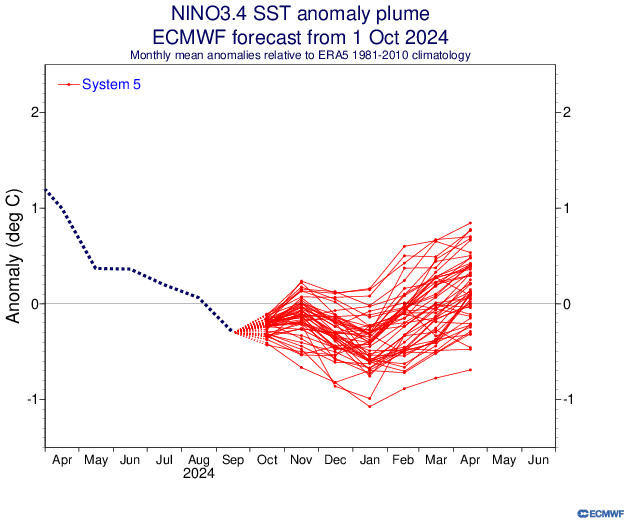
In light of the progged Easterly anomalies upon us now and current SSTA's, it's hard to buy the November spike in SSTA anomalies on this run attached. How that would change other forecasting parameters is anyone's guess.
-
Much better than September with December and January just below. Here's last month.

