mitchnick
-
Posts
26,213 -
Joined
Content Type
Profiles
Blogs
Forums
American Weather
Media Demo
Store
Gallery
Everything posted by mitchnick
-
Central PA Autumn 2023
mitchnick replied to Itstrainingtime's topic in Upstate New York/Pennsylvania
There's 2 Mt. Joys. One over near Bonneauville, a few miles east of Gettysburg, and another just east of the Susquehanna River in Lancaster County. They may live in different ones idk. -
Central PA Autumn 2023
mitchnick replied to Itstrainingtime's topic in Upstate New York/Pennsylvania
Ahh. Never counted mows, but I know this year was thankfully low. -
Central PA Autumn 2023
mitchnick replied to Itstrainingtime's topic in Upstate New York/Pennsylvania
Nope, low man again. .7" here. -
Central PA Autumn 2023
mitchnick replied to Itstrainingtime's topic in Upstate New York/Pennsylvania
Looks like this is not the end of the rain. Eps and Geps both have the coastal system on days 8-9 hitting us bringing total qpf for the runs just below and just above 3". Gefs aren't quite as wet topping out for the run just over 2". -
Central PA Autumn 2023
mitchnick replied to Itstrainingtime's topic in Upstate New York/Pennsylvania
Rain has just resumed here. -
Throw out the seasonal forecasts "maybe"? Welp, that sums up the value of most of the internet know-it-alls.
-
Central PA Autumn 2023
mitchnick replied to Itstrainingtime's topic in Upstate New York/Pennsylvania
.4" with a lull -
Central PA Autumn 2023
mitchnick replied to Itstrainingtime's topic in Upstate New York/Pennsylvania
HRDPS (affectionately the Herpes), which is the high resolution Rgem, has been painting a .75"+ strip over York County on westward for several runs. This is the 12z. Imby, I'd say it's doing best so far. -
Well, until they can get better enso forecasts, MEI is probably a bridge too far. But it would be something else to argue about!
-
I agree. I'm just in no mood to roll the dice with a straight up super MEI, and that's looking less likely as each day goes by so far.
-
Central PA Autumn 2023
mitchnick replied to Itstrainingtime's topic in Upstate New York/Pennsylvania
. 18" so far after a good 45 minutes of steady rain. Light stuff now but more on the way. -
Central PA Autumn 2023
mitchnick replied to Itstrainingtime's topic in Upstate New York/Pennsylvania
《Sheepishly raises hand》 -
Central PA Autumn 2023
mitchnick replied to Itstrainingtime's topic in Upstate New York/Pennsylvania
Ahh, you forget my feelings toward grass. -
Central PA Autumn 2023
mitchnick replied to Itstrainingtime's topic in Upstate New York/Pennsylvania
Sorry folks, but if you don't do a short mow the day before the first progged snow, regardless of the month, you'll have to return to detention at Weenie High. -
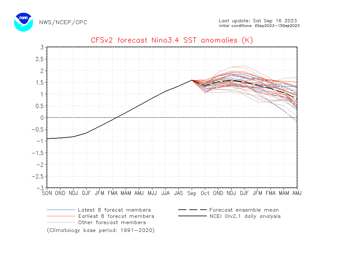
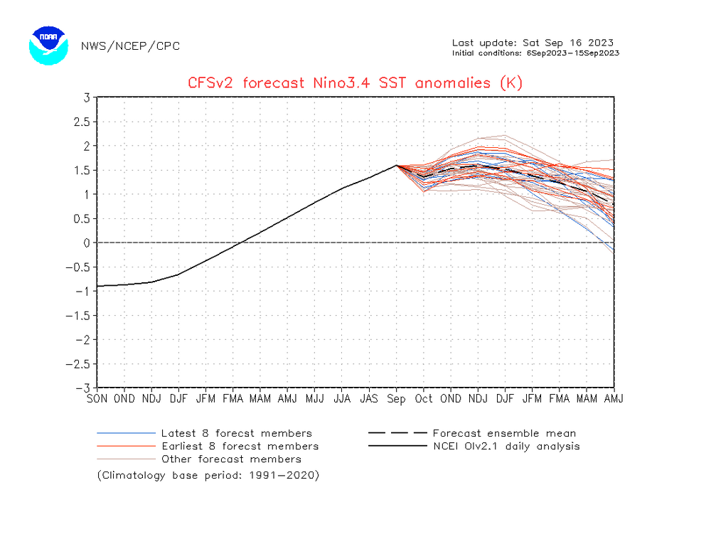
When you get short term fails like the ones you suggest (and the numbers don't lie), it's hard to believe the October updates for the winter won't be knocked down a few pegs. Which then begs the question how much can the MEI rise between September's number and October's? Pure speculation, but anything greater than .2 would be surprising to this weenie, and that would likely end chances of an MEI in a super range.
-
Central PA Autumn 2023
mitchnick replied to Itstrainingtime's topic in Upstate New York/Pennsylvania
Early precip starts usually mean qpf overperformers. -
Looks like the CFS wants to fire up the MJO starting around the 10th of October but is pretty benign until then. The progged MJO activity coincides with 3.4 rising on the bottom graph. Is it right? Probably to some extent in light of other modeling.Color Shades = Wind Anomalies (Yellow = Westerly Anomalies/Active MJO & Blue = Easterly Anomalies/Inactive MJO)Red Countours indicate MJO Phase (Solid = Active Phase & Dotted = Inactive Phase)Black Countours indicate High or Low Pressue Bias (Solid = Low Pressure/possible El Nino & Dotted = High Pressure/possible La Nina)
-
Central PA Autumn 2023
mitchnick replied to Itstrainingtime's topic in Upstate New York/Pennsylvania
Will do.....more than once too. -
Central PA Autumn 2023
mitchnick replied to Itstrainingtime's topic in Upstate New York/Pennsylvania
Weatherwise, none of the modeling has killed our chances tomorrow. Looks like somewhere between .3"-.6" qpf conservatively. I'll disregard any model greater than .6" until there's a consensus tomorrow at 12z. Footballwise, I'm glad I lost interests in sports years ago and relegate all my frustration with things out of my control to weather. -
Central PA Autumn 2023
mitchnick replied to Itstrainingtime's topic in Upstate New York/Pennsylvania
48.9 here for a low -
Central PA Autumn 2023
mitchnick replied to Itstrainingtime's topic in Upstate New York/Pennsylvania
6z Euro fwiw. -
Central PA Autumn 2023
mitchnick replied to Itstrainingtime's topic in Upstate New York/Pennsylvania
Absolutely. Globals have had everything too far south and west. It really seems that the model with the least qpf has been the winner. That said, 3k Nam hasn't done bad here because it's usually been the driest, or 1 of the driest. Still too early to get excited with what it's showing, but I'll take it as encouraging for now. -
Central PA Autumn 2023
mitchnick replied to Itstrainingtime's topic in Upstate New York/Pennsylvania
6z 3k Nam loves yby. -
Central PA Autumn 2023
mitchnick replied to Itstrainingtime's topic in Upstate New York/Pennsylvania
Wow. The only leaves that have fallen here are from the dry conditions. I do see some color showing up on Pigeon Hills, but you have to look hard. Eps qpf has traditionally been pretty good, at least when it's showing the lowest for snow events. Hopefully the "alleged" recent upgrades will be just that. We obviously have some time before winter to see. -
Central PA Autumn 2023
mitchnick replied to Itstrainingtime's topic in Upstate New York/Pennsylvania
0Z Eps qpf for Sunday.