

mitchnick
-
Posts
26,213 -
Joined
Content Type
Profiles
Blogs
Forums
American Weather
Media Demo
Store
Gallery
Everything posted by mitchnick
-
On and off snow showers continue here surprisingly. Here are a couple of pics. Don't know how to convert from download only. 20231206_102529.heic 20231206_102527.heic 20231206_102526.heic
-
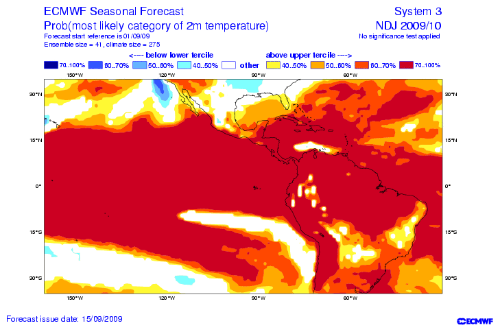
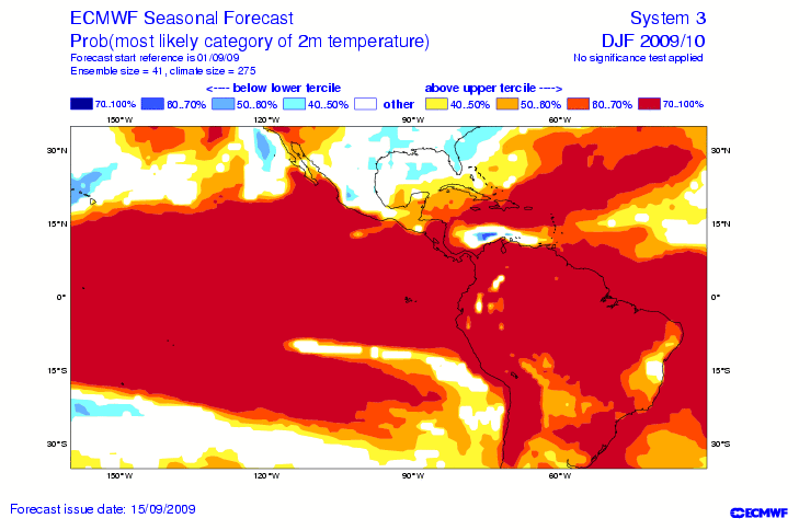
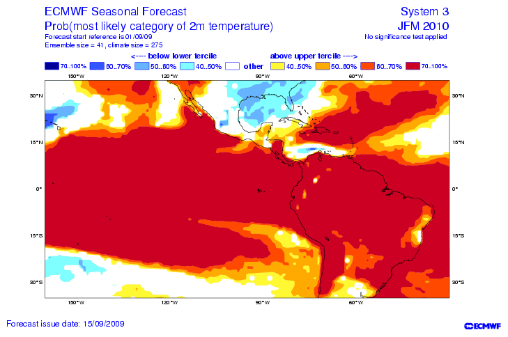
Needless to say, there have been a few upgrades with the Euro suite (and other modeling), data ingestion, etc. in the past 8 years. I don't know what looking at past modeling does. But if we're going to look, here's a few seasonal forecasts from the Euro off the 9/09 run. Unfortunately, the free data back then was paultry, so all I have are the temp forecasts. Pretty good forecast.
-
Cfs, but it was premature.
-
Hmmm...legit light snow now and radar has more, if not, better returns headed this way. More than I expected, and there aren't any bigger weenies than me!
-
6z Eps supports the threat too. Yaaaayyyy....snow threat on 2 consecutive Eps runs. Actually, a bit better on 6z run too.
-
Random flakes falling.
-
You can get the last 7 days here: https://charts.ecmwf.int/products/extended-zonal-mean-zonal-wind?area=nh&base_time=202311280000
-
I posted a few days ago that temps would be dropping and you doubted me to put it lightly. But they dropped. If you look at the modeling over the past 5-7 days (Euro, Gfs and Cfs), they haven't been consistently getting stronger with the WWB. There's been a lot of up and down with no real consensus. So I don't know if your claim it's getting stronger is from posters or modeling, but I wouldn't characterize it as strengthening at this point. Also, it seems a good bit of the westerly anomalies are west of the dateline and the WWB's this fall that were similar failed to warm as progged or advertized by Twitter posters you linked or modeling. There's still time for it to get its act together and boost temps more to your liking, so there's that I suppose.
-
Euro Seasonal https://www.americanwx.com/bb/topic/58841-el-nino-2023-2024/?do=findComment&comment=7071624
-
Studies done by people like minded with you? No, I know what a study looks like when the conclusion was written before the study was conducted The fact is, all your post demonstrated was that ensemble forecasts at long leads are inaccurate and poorly forecast intensity of forcing. You want to turn it into something more. I'm done.
-
I expected something better than your typical response.
-
Thanks for not responding to any of my points.
-
If you watch these forecasts daily as I do, you will see that the long range forecasts for both positive AND negative anomalies are almost always weaker than reality i.e. typical ensemble forecasting. As proof, look at both the yellow and green areas on the 11/26 map and compare them. Otoh, this forecast period could be a cherry pick. The other problem is that I agree MJO forecasts aren't that great in general. Thus, I don't think you can say with certainty modeling is going to always be too weak with warm phases or too strong with cold ones. And if you can't say it with certainty, it offers no additional forecasting assistance and you're left guessing when it's too weak and when it's not. Regarding this month's Conus numbers, why don't we wait until the end of the month for actual numbers instead of assuming it ends up one way or the other? Clearly, it's looking on track for a typical December strong or super Niño. But since we have 25/30 of the month remaining, it probably makes better sense to wait before claiming that late November MJO forecasts for the early/mid month were flawed. Jmho
-
-
November QBO -15.94 https://www.cpc.ncep.noaa.gov/data/indices/qbo.u30.index
-
I'm not on any train. I'm observing and posted actual conditions and 1 model's prog. Whether the MJO forcing makes it to 7-2 and what the consequences are remains to be seen. But there are other factors to the weather than the MJO. Moreover, the intensity and speed of the MJO passage will obviously have different effects on SSTA and weather.
-
2015. But a few weeks later...
-
Just in case anybody is interested, I found these OLR maps from late January and early February, 2010 in my desktop. I figure they might avoid some disagreement among memories as we get further along for comparisons. I have a few more from early February if anyone wants me to post them.
-
For those in the east that want to see a winter, you probably couldn't put the max heat potential in a better spot.
-
Probably not the end of it looking at the Oisst SSTA map and modeling showing continuing trades for around 7 days+. Cfs maps also attached are unimpressed with WWB showing future cooling. Of course, it's just 1 model.
-
How low can we go? Answer: lower than yesterday! Lol Didn't want to steal your "baby" @GaWx, but I couldn't believe how much it dropped.
-
Today's weekly Eps not only held serve with a trough in the east starting Christmas, but the trough is deeper and temps colder! Normal precip for the last 3 of the 6 week forecast period.
-
I used to think that was bs, but I can't remember a great winter that didn't have them. So now I'm a believer...he!! it doesn't cost anything either!
-
12z ain't a win....but 18z is! Lol. Incredible the amount of digital snow we get.
-
Woke up this morning and thought my porch was on fire with a reading of 137°. Guess I'll need to buy a new thermometer.


