

mitchnick
-
Posts
26,213 -
Joined
Content Type
Profiles
Blogs
Forums
American Weather
Media Demo
Store
Gallery
Everything posted by mitchnick
-
The refreshing thing is that next year won't look like that, but there's no support for it in the first place.
-
It never ends. Icon
-
Today's updated March Cansips looking warm neutral to me. Here's a link to December. You can scroll forward from there. https://www.tropicaltidbits.com/analysis/models/?model=cansips®ion=global&pkg=ssta_noice&runtime=2025030100&fh=9 On a different note, looks like a decent amount of blocking through the winter with cold along the northern tier into the MA fwiw.
-
I think this winter proved indisputably that using alphabet indexes exclusively for winter forecasting is far from a lock. To assume those indexes can be accurately forecasted in advance is equally as risky imho. Then throw in the nuances like variability during the winter and trends over the winter contrary to the anticipated final number (switching from + to - and vica versa) to name just a few, and it's accuracy is a cr@p shoot.
-
Your rolled forward didn't work this winter with the warmth and the PDO rose above -1 from -2, so it's not a guarantee, like everything else in weather prediction.
-
Almost there fwiw.
.png.d398c03d1e34a8206178ce7803e5c3e6.png)
-
-
AI is south and not much. Looks more like a front. Completely lost the storm look. P.s. comes out early since yesterday's upgrade
-
It's 10:1 and temps are marginal,so it overdone even if it occurred as depicted. So it would still be a fail imby in all likelihood acting as the final dagger in the back of this winter by missing me to the north instead of south. Do I have the weenie mentality down or what? Lol
-
You mean spring?
-
That explains the jump in VA & WVA on the 24hr snowfall mean.
-
18z AI keeps it south.
-
And when you consider that all the ensemble 50% probabilities were as impressive as they were in addition to the means, it's an absolute head shaker, if not head against wall pounder!
-
That is correct. BWI had accumulating snows all 4 days.
-
Snow started at my house 2 miles north of BWI Friday night. It dropped a little over 2". That was the Arctic front. Snow stopped Saturday morning early, but then started back up late morning and lasted until late afternoon on Saturday. Saturday night featured a virga Blizzard. I dragged my wife and 2 kids out for a ride to "look for snow." We headed down Rt. 295 toward DC and finally had a few flurries not too far north of the DC line. I headed back home. When you get off of 295 by heading north toward Baltimore onto the Baltimore Beltway, you get a clear view of the Baltimore city skyline. The snow ceiling was incredibly low that night thanks to the Arctic air and you could see the snow above the city lit by the yellowish mercury vapor street lights. There were striations in the virga/ceiling. I'll never forget that view. When I got home and looked northward, I could still see the low ceiling gently dropping at that point. The snow started incredibly heavy and stayed that way all night dropping around a foot. I had 2 lightning strikes with the heavy snow that night. The NWS combined the 4 days (Fri-Mon) into 1 event and recorded 28.2" for the total, which would have been more had we not gotten heavy sleet late Sunday night into early Monday morning.
-
Heisey, I haven't looked at them, but the AI has ensembles. Lousy graphics, but this is the link to them fwiw. https://charts.ecmwf.int/?facets={"Product type"%3A["Experimental%3A AIFS"%2C"Experimental%3A AIFS Ensemble forecast"]%2C"Parameters"%3A[]%2C"Type"%3A[]%2C"Range"%3A[]}
-
Nope. 1 inch still a touch to my north. Plus it's 10:1, and temps suggest snow TV at best.
-
Heisey, et al., Pivotal has updated AI and now has snowfall. Here's the 6z run.
-
Cansips last year was predicting a strong Niña at this point and other modeling was weak to moderate. So everything was too cold since a 5 trimonthly Niña looks doubtful. So predictions at this point are pretty much a cr@p shoot imho. That said, for the sole purpose of making an early "guess", I'll go with a warm La Nada or weak Niño.
-
0z AI looked like last week's event with precip centered mainly south, but probably rain. 6z just out (this is an earlier time than before and the website changed too, so it's probably the upgraded version) is a big rainstorm.
-
Come to think of it, today was the upgrade. Maybe that's why there's nothing new on TT and Pivotal. Idk, just a thought.
-
Surface temps would be the hurdle and it's obviously way to early to know that. Of course, it could easily be gone come 0z, but hopefully it gives us 1 more shot. If not, then bring on the warmth.
-
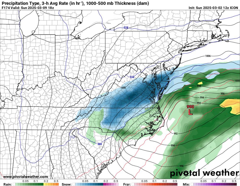
18z has a real snowstorm on 3/9. Actually has a light appetizer on the 8th too. Surface temps are marginal, but looks like snow west and north of I95. Will need to wait on TT or Wxbell to confirm surface, but 850's are cold enough.
-
18z Gfs. Don't ask how, just accept it without questions. Lol


