cstrunk
-
Posts
589 -
Joined
-
Last visited
Content Type
Profiles
Blogs
Forums
American Weather
Media Demo
Store
Gallery
Everything posted by cstrunk
-

January 10-11 Severe Weather Threat
cstrunk replied to DanLarsen34's topic in Central/Western States
Crazy to see this kind of wording at Day 5. Lots of time for changes.
-
Texas/New Mexico/Louisiana/Mexico Obs And Discussion Thread Part 8
cstrunk replied to wxmx's topic in Central/Western States
Brrrr. I'm surprised it's this cold already and it's not even officially winter. -
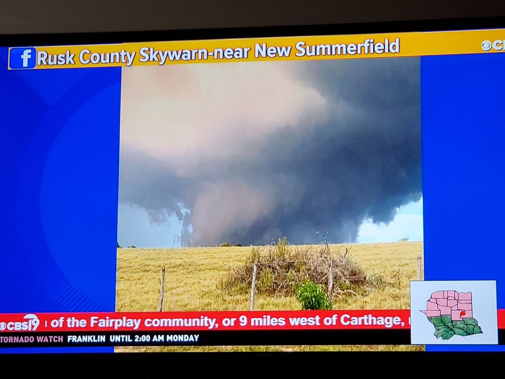
Confirmed tornado near Fairplay, TX (9 mi west of Carthage). This pic shared on local news recently.
-
Tornado warning Panola County TX.
-
Texas/New Mexico/Louisiana/Mexico Obs And Discussion Thread Part 8
cstrunk replied to wxmx's topic in Central/Western States
I ended up with 0.6" rain at my house, more than I thought! -
Texas/New Mexico/Louisiana/Mexico Obs And Discussion Thread Part 8
cstrunk replied to wxmx's topic in Central/Western States
Cold front is on its way through... thought all of the precipitation would miss me but we're getting a tail-end storm finally. It won't be a lot but it's something at least! -
Texas/New Mexico/Louisiana/Mexico Obs And Discussion Thread Part 8
cstrunk replied to wxmx's topic in Central/Western States
The forecast high for Monday is 73. After a mid-week warmup, next Friday and Saturday will only reach the upper 60's. Fall is here (finally)! -
Plains States Observations and Discussion Thread
cstrunk replied to lookingnorth's topic in Central/Western States
I'm definitely looking forward to some cooler temps next week. September was a heater. And would a little bit of rain be too much to ask for? -
Texas/New Mexico/Louisiana/Mexico Obs And Discussion Thread Part 8
cstrunk replied to wxmx's topic in Central/Western States
I ended up getting 1.6" from yesterday around noon until this morning at 7:30 AM. The radar estimate seems way off, as it shows that I should have only had about 0.3". I guess the small droplet size had something to do with that? -
Texas/New Mexico/Louisiana/Mexico Obs And Discussion Thread Part 8
cstrunk replied to wxmx's topic in Central/Western States
Oh wow, that's nuts. Is that the only model that picks up on this that you've seen? Hopefully that's an outlier and can be disregarded, but it would be nice if we ended up with more than an inch. Just not 12". -
Texas/New Mexico/Louisiana/Mexico Obs And Discussion Thread Part 8
cstrunk replied to wxmx's topic in Central/Western States
I'm curious, where do you go to view the Euro model? I use COD weather but it doesn't have that model. Everything on there looks like 0.5"-1" for at least the Longview area now, instead of 2-4" from yesterday. -
Texas/New Mexico/Louisiana/Mexico Obs And Discussion Thread Part 8
cstrunk replied to wxmx's topic in Central/Western States
Hopefully the flooding isn't too bad, but many areas could surely use the rain. -
Texas/New Mexico/Louisiana/Mexico Obs And Discussion Thread Part 8
cstrunk replied to wxmx's topic in Central/Western States
It's hot and dry... this week doesn't look much different, although temperatures should be in the mid-90's compared to the 100's over the last few days. Very small chances for rain Mon-Wed. -
Texas/New Mexico/Louisiana/Mexico Obs And Discussion Thread Part 8
cstrunk replied to wxmx's topic in Central/Western States
Cashed in on the recent mini-drought in my backyard big-time today. Some of the hardest rain I've seen all season, combined with a bit of small hail and 20+ minute barrage of crazy close-range CG lightning. I ended up with 2.6" of rain in a little over an hour. -
Texas/New Mexico/Louisiana/Mexico Obs And Discussion Thread Part 8
cstrunk replied to wxmx's topic in Central/Western States
Doesn't look promising. I guess I'll have to keep watering my lawn! -
Texas/New Mexico/Louisiana/Mexico Obs And Discussion Thread Part 8
cstrunk replied to wxmx's topic in Central/Western States
Same here. It does look like the outflow from this morning convection to the south has stalled near or just north of Longview, and there is an area of agitated cumulus that may turn into a few storms/showers with continued strong insolation along the boundary. -
Texas/New Mexico/Louisiana/Mexico Obs And Discussion Thread Part 8
cstrunk replied to wxmx's topic in Central/Western States
Ditto, except we haven't had a good shower yet. I'm hoping to cash in on one today yet before it dries out for a while again. -
Texas/New Mexico/Louisiana/Mexico Obs And Discussion Thread Part 8
cstrunk replied to wxmx's topic in Central/Western States
It's been dry IMBY since the bonus rain last week. It finally feels like mid-late summer here, with temperatures in the upper 90's today and through the extended forecast, and no rain expected. I'll have to water my lawn this weekend for only the 2nd time all year! -
Texas/New Mexico/Louisiana/Mexico Obs And Discussion Thread Part 8
cstrunk replied to wxmx's topic in Central/Western States
Cashed in on 0.50" of rain yesterday afternoon, and 1.85" early this morning in a storm that woke me up. Great timing as I could tell my grass was beginning to fade a bit from it's lush green nature I have enjoyed all spring/summer so far. I've only watered one time all year. -
Texas/New Mexico/Louisiana/Mexico Obs And Discussion Thread Part 8
cstrunk replied to wxmx's topic in Central/Western States
We had about 45 mph gusts, but only received a few sprinkles IMBY. Disappointing combined with the forecasted track of Barry shifting farther east. We probably won't end up with much from that either. -
Texas/New Mexico/Louisiana/Mexico Obs And Discussion Thread Part 8
cstrunk replied to wxmx's topic in Central/Western States
Surprise, surprise, the MCS from KS is knocking on my door. -
Texas/New Mexico/Louisiana/Mexico Obs And Discussion Thread Part 8
cstrunk replied to wxmx's topic in Central/Western States
Quite a westward shift. Obviously still a long ways out, but at least it's something interesting to follow. Flooding will likely be the biggest threat (barring major intensification), but fortunately east Texas and LA haven't received as much rain recently as they did in spring, for the most part. -
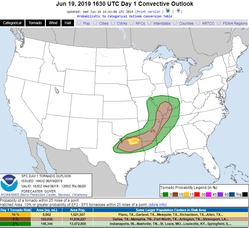
I agree with SPC concerning the tornado threat, my concern is for potentially wind-driven very large hail. That would be no fun. *edit - Towers are going up north of DFW. Initiation seems likely soon.
-
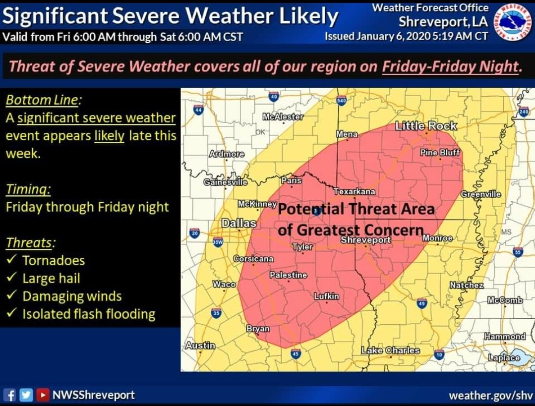
There was a tornado warning near/west of Marshall, TX and there were reports of wind damage, it wouldn't surprise me to have a survey crew confirm a tornado in that location. I had some strong winds in Longview from that line, but I think the worst winds hit just north of me. Models are showing supercell initiation in the 5-7 PM time frame this evening near and NE of the DFW metro.
-
SPC added a small 10% area for initial supercell development expected late this afternoon/early evening just northeast of DFW. Larger area of hatched hail/wind probabilities as well. The storms are expected to quickly merge into a southeastward moving severe MCS.