

cstrunk
-
Posts
589 -
Joined
-
Last visited
Content Type
Profiles
Blogs
Forums
American Weather
Media Demo
Store
Gallery
Everything posted by cstrunk
-
Pretty strong wind with very heavy rain with the line that moved through Longview this morning. My boss's shed landed in my backyard. Fences are fine so it went airborne.
-
That Day 1 upgrade for tornado probabilities is concerning for NTX and S/C OK since it will be a late night/early morning threat. Hopefully storm mode stays messy and it doesn't get out of hand.
-
Tuesday is definitely on my radar for threat to my local (ETX) area, but the highest threat seems to be into AR and LA at this time. BTW - The dates should be 3/4 and 3/5.
-
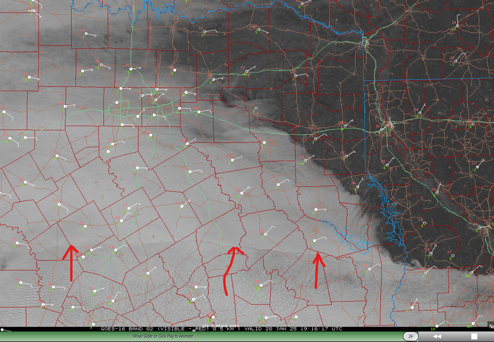
Interesting satellite imagery... can someone explain what this feature is that is rapidly expanding north? Seems like some kind of mid-layer moisture (causing clouds) advecting northward?
-
06z GFS has the storm on Tuesday the 21st now. 18" of snow in deep ETX.
-
Around 5:30 pm we dropped to 31.8F and stayed there until a little while ago, rose to 32.2F. About the worst possible winter weather situation.
-
Agree. WAA/warm nose wins.
-
Might be something around/after New Year's Day... according to GFS.
-
Changes coming later next week, it seems. Just in time for my wedding weekend.
-
Pretty common in Longview. Too many trees next to above ground electric lines.
-
 Luckily, none for me!
 -
I ended up with 1" on Sunday and 5.25" yesterday on the north side of Longview. The tornado warnings yesterday were something else.
-
At my house, I got 1.00" of rain on Sunday, and 5.25" yesterday from Beryl. Yesterday was pretty wild with all of the tornado warnings in E TX and NW LA. Winds were a little gusty at times yesterday afternoon, but thankfully we only lost power once for about 20 seconds and that was all.
-
Keeping an eye on Beryl...
-
I'm on day 8 in a row with measurable rainfall, with several multi-inch events within this span. Tomorrow morning will likely be day 9.
-
Another MCS moving through NE Texas. Another one likely later tonight/tomorrow morning.
-
Yeah it's been quite the stretch here. Don't think we're done yet either.
-
It's mid-afternoon, there's a MCS diving SE from Oklahoma into huge CAPE (4000-6000 J/kg), mid-upper 70's dew points, adequate bulk shear (35-40 knots), 100-200 m2/s2 helicity, and yet it's not severe. What's holding it back?
-
Yeah that was a nasty storm in West Texas. My post was focused on my area in East Texas, I should have been more clear. We ended up with 3.27" of rain yesterday. Just a bit of light rain this morning, 0.12" so far and I don't expect much more. I'm looking forward to some drier weather, I need to mow my lawn!
-
Well there were a few rotating storms along I-20 in East Texas this afternoon but nothing tightened up. There was one tornado warning near Marshall, TX.Now the focus is very heavy rain. A very large flash flood warning has been issued along those same areas of I-20 for this area. Not much lightning and thunder.
-
The enhanced risk was pretty good, but the slight risk extending up towards Texarkana was a bust. Models never really showed much north of I-10 in TX and LA, due to the substantial convection across S/SE TX and S LA... and that's what happened. Marginal risk for the northern uncertainty would have sufficed (and still not verify).
-
I-10 special today from San Antonio through Houston later mostly for wind/very large hail. Ended up with 1.49" yesterday.
-
1.26" so far today in Longview and it's not quite done yet. Nice soaking rain. I think tomorrow's severe threat is going to get pushed farther south/east again. Models not looking impressive (IMO) due to lingering precip tonight/tomorrow morning across areas of eastern Texas.
-
I agree. Looks like SPC disagreed with the Enhanced delineation in the area I mentioned... and even nudged it slightly more north. I wonder what they are seeing.
-
The DFW area still looks to be ground zero for the supercell/hail threat this afternoon. I think the Enhanced Risk is delineated too far to the north, once you get east of there. I wouldn't be surprised if it gets trimmed back south closer to I-20 in NE TX and N LA, as opposed to extending along I-30 in NE TX to Texarkana and southern Arkansas.


