

marsman
-
Posts
459 -
Joined
-
Last visited
Content Type
Profiles
Blogs
Forums
American Weather
Media Demo
Store
Gallery
Everything posted by marsman
-
High of 74.2 at 2:25pm. Definitely airing out the house!
-
Southeast Sanitarium - Winter 23/24 Edition
marsman replied to eyewall's topic in Southeastern States
Here's one from 1991. I remember the screen before this, where it was a blue screen with white text, I think that's what you're talking about. When they updated to this style, with the animations of rain and all, I was blown away, and it's the style I remember the most: -
Southeast Sanitarium - Winter 23/24 Edition
marsman replied to eyewall's topic in Southeastern States
"Hope is a dangerous thing. Hope can drive a man insane." -Red, from The Shawshank Redemption -
Lows of 15.9 yesterday, Jan 21st, 18.1 this morning. High of 50 this afternoon today! I took a jacket off!
-
Prelim: 2x tornadoes on Harkers Island, NC:
-
1.89" of rain from yesterday. Max wind of 27mph, which is very high for here, as my station is well below the treeline. High of 65 at 6pm. Only a flicker of the lights, power stayed on. Seeing a lot of damage pictures, especially along the coast.
-
36.7 this morning. Laser thermometer shows the deck temp at 32.6. No icing to be found. .06" in the bucket so far.
-
2.72" from yesterday. Sunny and 58F outside. One of those days in the car where the window can go down just a bit, and you don't need A/C or heat.
-
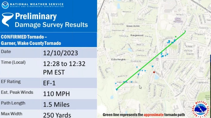
2.92" IMBY. Prelim path of tornado from NWS Raleigh:
-
Finally getting some good precip in Cary. .12" and climbing. Enjoyed yesterday, high of 72.1 at 3pm, got a lot of yardwork done knowing today was gonna be a wash.
-
74.5 yesterday for a high, ran the A/C in the afternoon, too much dust from all the leaf blowing to keep the windows open. Also only have .02" for the month. Hope that changes this week.
-
On the OBX this weekend and watching an interesting spot of convection just off the coast bringing in some clouds. Don’t recall seeing it on any forecasts.
-
Had what I would call a "heavy mist" occasionally coming down. I recorded 0.12" yesterday. Only 1.42" for the month. 38.5 for a low this morning.
-
High of 83.7 at 3:20pm, morning low was 57.7 at 7:30am.
-
2023 Atlantic Hurricane season
marsman replied to Stormchaserchuck1's topic in Tropical Headquarters
NHC will initiate advisories on Tropical Depression Twenty-One, located near the southern coast of Nicaragua, at 500 PM AST (2100 UTC). -
2023-2024 Fall/Winter Mountain Thread
marsman replied to The Alchemist's topic in Southeastern States
Lots of mPING reports of hail on RadarScope. -
40.7 at 0615. Refreshing!
-
43 for a low at 7am.
-
000 WTNT61 KNHC 231020 TCUAT1 Tropical Storm Ophelia Tropical Cyclone Update NWS National Hurricane Center Miami FL AL162023 620 AM EDT Sat Sep 23 2023 ...OPHELIA MAKES LANDFALL IN NORTH CAROLINA... Doppler Radar images, Air Force Hurricane Hunter data and surface observations indicate that Ophelia made landfall near Emerald Isle in North Carolina around 615 am EDT (1015 UTC) with estimated maximum winds of 70 mph (110 km/h). An observation in Cape Lookout, North Carolina, recently reported sustained winds of 61 mph (98 km/h) with a gust to 73 mph (117 km/h). SUMMARY OF 620 AM AST...1020 UTC...INFORMATION ---------------------------------------------- LOCATION...34.7N 77.0W ABOUT 25 MI...45 KM WNW OF CAPE LOOKOUT NORTH CAROLINA ABOUT 75 MI...120 KM NE OF CAPE FEAR NORTH CAROLINA MAXIMUM SUSTAINED WINDS...70 MPH...110 KM/H PRESENT MOVEMENT...NNW OR 345 DEGREES AT 9 MPH...15 KM/H MINIMUM CENTRAL PRESSURE...981 MB...28.97 INCHES $$ Forecaster Kelly/Cangialosi/Papin/Delgado
-
NHC will initiate advisories on Potential Tropical Cyclone Sixteen, located offshore of the southeast coast of the United States, at 1100 AM EDT (1500 UTC).
-
Been watching Mount Washington's weather, might be the most interesting thing going on. Currently showing winds at 72mph, gusts to 82 and 38F. Clouds are ripping across the summit.
-
52.2 for a morning low at 6:45am. May be awhile before I see this again.
-
I found this to be a great pictorial and graphical article: Hurricane Florence 5 years on - Collaboration of NWS Morehead City, Raleigh, and Wilmington: https://storymaps.arcgis.com/stories/c77c7dd5e79b406581168c8073a08060
-
57.1 for a low this morning at 7am.
-
This morning: 1.74" from the storm coming through, flash flood warning up for parts of Wake county.


