AmericanWxFreak
-
Posts
1,624 -
Joined
-
Last visited
Content Type
Profiles
Blogs
Forums
American Weather
Media Demo
Store
Gallery
Everything posted by AmericanWxFreak
-
Also heading to FL tomorrow to start a 2 week vacation, I just so happened to book a pre trip day of PTO for today. So happy lol
-

-

Jan 18-19 Storm Threat: Bob Chill made me do it
AmericanWxFreak replied to stormtracker's topic in Mid Atlantic
Low popped off NC coast -
Jan Medium/Long Range Disco 2: Total Obliteration is Coming
AmericanWxFreak replied to Jebman's topic in Mid Atlantic
As of now, most guidance sees this as a snow beginning Friday AM and ending Friday PM. -
Jan Medium/Long Range Disco 2: Total Obliteration is Coming
AmericanWxFreak replied to Jebman's topic in Mid Atlantic
Probably most of it lol - most models at 0z last night were painting 3-4 still -
Jan 15-16 Storm Thread 3: Obs and Disco
AmericanWxFreak replied to stormtracker's topic in Mid Atlantic
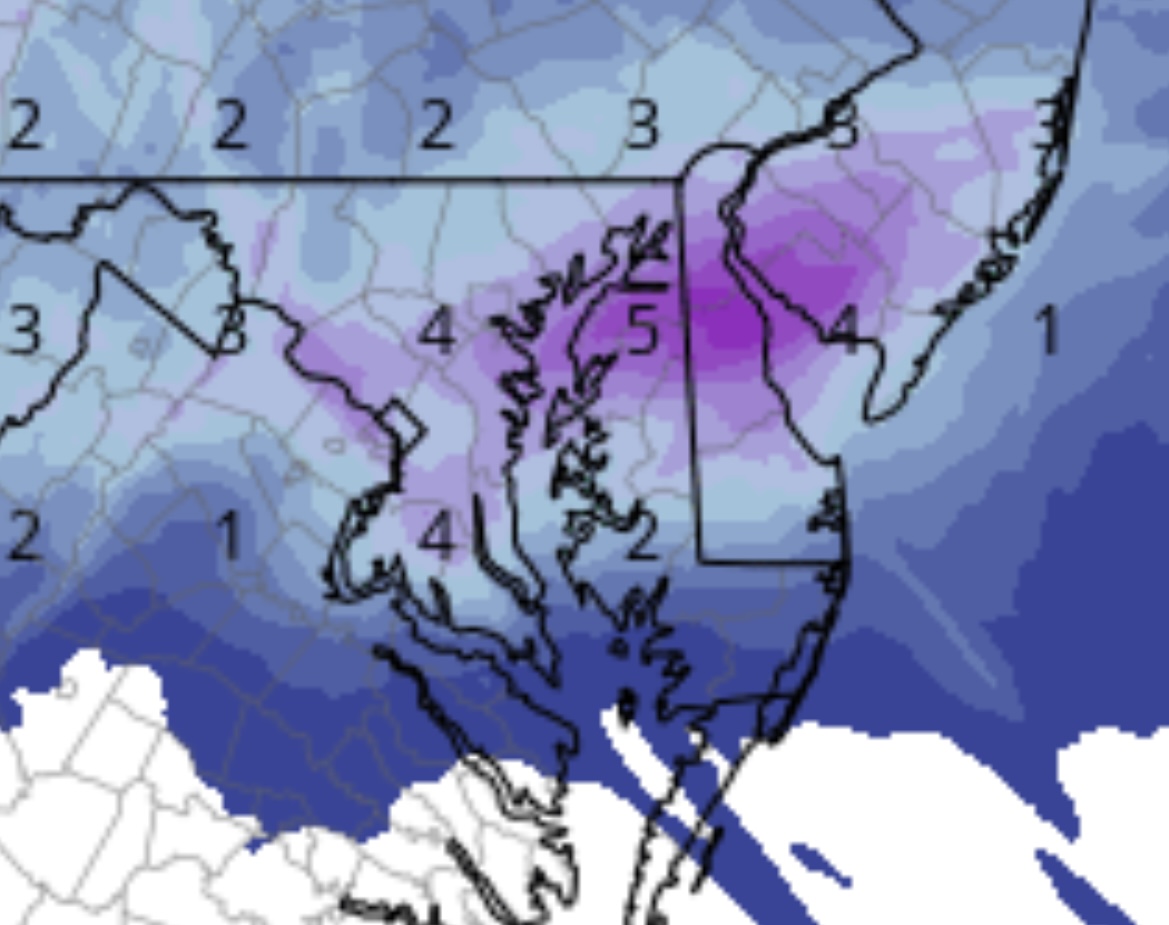
Very healthy dendrites under the good banding in HoCo -
Jan 15-16 Storm Threat Thread: The Return of Hope??
AmericanWxFreak replied to stormtracker's topic in Mid Atlantic
Are we forseeing daytime road stickage with this one or are we too marginal at the surface? -
Feels like winds here in Columbia are just as strong as the other night.
-
Jan Medium/Long Range Disco 2: Total Obliteration is Coming
AmericanWxFreak replied to Jebman's topic in Mid Atlantic
Isn't it a blend of models? Isn't the blend of models getting a bit worse? Wouldn't that be the expected result of the blended output? -
Jan Medium/Long Range Disco 2: Total Obliteration is Coming
AmericanWxFreak replied to Jebman's topic in Mid Atlantic
nervously awaits the "FOLKS" -
Jan Medium/Long Range Disco 2: Total Obliteration is Coming
AmericanWxFreak replied to Jebman's topic in Mid Atlantic
P15 would be a jolly good time -
Tuesday, January 9 Rain and Wind Storm
AmericanWxFreak replied to Weather Will's topic in Mid Atlantic
TVS indicator on the stuff east of Fredericksburg -
Tuesday, January 9 Rain and Wind Storm
AmericanWxFreak replied to Weather Will's topic in Mid Atlantic
Sky just lit up with transformers blowing in the distance in downtown Columbia. Wild. -
Tuesday, January 9 Rain and Wind Storm
AmericanWxFreak replied to Weather Will's topic in Mid Atlantic
Fire and EMS dispatched to a home in Columbia for a downed tree into house - so it begins -
Tuesday, January 9 Rain and Wind Storm
AmericanWxFreak replied to Weather Will's topic in Mid Atlantic
URGENT - WEATHER MESSAGE National Weather Service Baltimore MD/Washington DC 1225 PM EST Tue Jan 9 2024 DCZ001-MDZ013-016-504-506-VAZ053>055-057-527-100130- /O.UPG.KLWX.WI.Y.0001.240109T2000Z-240110T0600Z/ /O.EXA.KLWX.HW.W.0001.240109T2000Z-240110T0600Z/ District of Columbia-Prince Georges-Charles- Central and Southeast Montgomery-Central and Southeast Howard- Fairfax-Arlington/Falls Church/Alexandria-Stafford-King George- Central and Southeast Prince William/Manassas/Manassas Park- Including the cities of Washington, Bowie, Suitland-Silver Hill, Clinton, College Park, Greenbelt, Laurel, Camp Springs, St. Charles, Waldorf, Bethesda, Rockville, Gaithersburg, Silver Spring, Columbia, Ellicott City, Reston, Herndon, Annandale, Centreville, Chantilly, McLean, Franconia, Arlington, Alexandria, Falls Church, Falmouth, Dahlgren, Dale City, Manassas, Woodbridge, Lake Ridge, and Montclair 1225 PM EST Tue Jan 9 2024 ...HIGH WIND WARNING IN EFFECT UNTIL 1 AM EST WEDNESDAY... * WHAT...Southeast winds 25 to 40 mph with gusts up to 60 mph expected. * WHERE...In District of Columbia, District of Columbia. In Maryland, Prince Georges, Charles, Central and Southeast Montgomery and Central and Southeast Howard Counties. In Virginia, Fairfax, Stafford, King George and Central and Southeast Prince William/Manassas/Manassas Park Counties, and Arlington/Falls Church/Alexandria. * WHEN...Until 1 AM EST Wednesday. * IMPACTS...Damaging winds will blow down trees and power lines. Widespread power outages are expected. Travel will be difficult, especially for high profile vehicles. -
Tuesday, January 9 Rain and Wind Storm
AmericanWxFreak replied to Weather Will's topic in Mid Atlantic
I always sit back and giggle at people who don't understand the logic behinds these decisions. Its pretty clear cut to me. Glad these people aren't risk managers for a living -
Tuesday, January 9 Rain and Wind Storm
AmericanWxFreak replied to Weather Will's topic in Mid Atlantic
So is the general idea a swath of 1-3" of rain with some lollis under banding and along the ridges? -
Yep, 2.3 magnitude quake NW of DC at 12:50am. https://x.com/LastQuake/status/1742064321184530496?s=20
-
Earthquake I think?
-
My entire local neighbors group freaking out
-
I now see the period I missed the first time. Lame. Lol
-
this is late and off topic now, but important to know for this upcoming season - PSU joined team hoco?
-
2 what looked to be F-22s just screamed over Jessup. Interesting…
-
Another round of highly electrical storms passing through. Impressive that temps are now into the upper 60s yet there is still so much charge in the air.
-
2023 Mid-Atlantic Severe Wx Thread (General Discussion)
AmericanWxFreak replied to Kmlwx's topic in Mid Atlantic
Amazing light show in downtown Columbia- 2,785 replies
-
- 1
-

-
- severe
- thunderstorms
- (and 3 more)