AmericanWxFreak
-
Posts
1,698 -
Joined
-
Last visited
About AmericanWxFreak

Recent Profile Visitors
4,521 profile views


-
 Wierd. Couple of lightning indicators out in western MD. .
 -
...Carolinas to the Mid-Atlantic/Northeast... Large-scale outflow from ongoing broken linear bands along with a separate swath of convection with the low-level warm conveyor have greatly hampered the amplitude of diurnal destabilization across the Carolinas to the DE Valley. Primary severe threat should remain with the pre-frontal linear bands as they spread east-northeast this afternoon. Some intensification may yet occur across eastern SC/southern NC within pockets of low 70s surface temperatures. See MCDs 272-273 for additional storm-term discussion. Farther north, a pre-frontal low-topped convective line is evolving across central PA. This should be the primary driver of afternoon severe potential northeastward into parts of NY as mid 50s to low 60s surface dew points remain prevalent just ahead of this line. Within a deeply meridional wind profile, damaging winds and embedded tornadoes will be the main hazards. This activity should remain spatially confined by a lack of downstream boundary-layer destabilization over eastern NY into New England. In the wake of this leading activity, a second round of low-topped convection will likely reform east of the Blue Ridge into the Piedmont towards late afternoon/early evening. Prior overturning and persistent cloud coverage should mitigate appreciable boundary-layer destabilization. However, robust large-scale ascent and intensifying lower-level winds will accompany the ejection of a 100+ kt 500-mb jetlet within the basal shortwave trough. This should yield a renewed threat for damaging winds accompanying the fast-moving line. Even with meager buoyancy, another round of sporadic severe gusts should occur from NC/VA to the Chesapeake Bay/DE Valley vicinity through this evening.
-
This might have been the most exciting batch of the day...
-
Some crapvection forming along 95 between the main batches
-
I know where my money is. The same weenies called for a complete bust the other day when we were cloudy early on.
- 1,093 replies
-
- 1
-

-
- severe
- thunderstorms
- (and 1 more)
-
Will be interesting to see what SPC does with this shift in guidance
-
2026 Mid-Atlantic Severe Storm General Discussion
AmericanWxFreak replied to Kmlwx's topic in Mid Atlantic
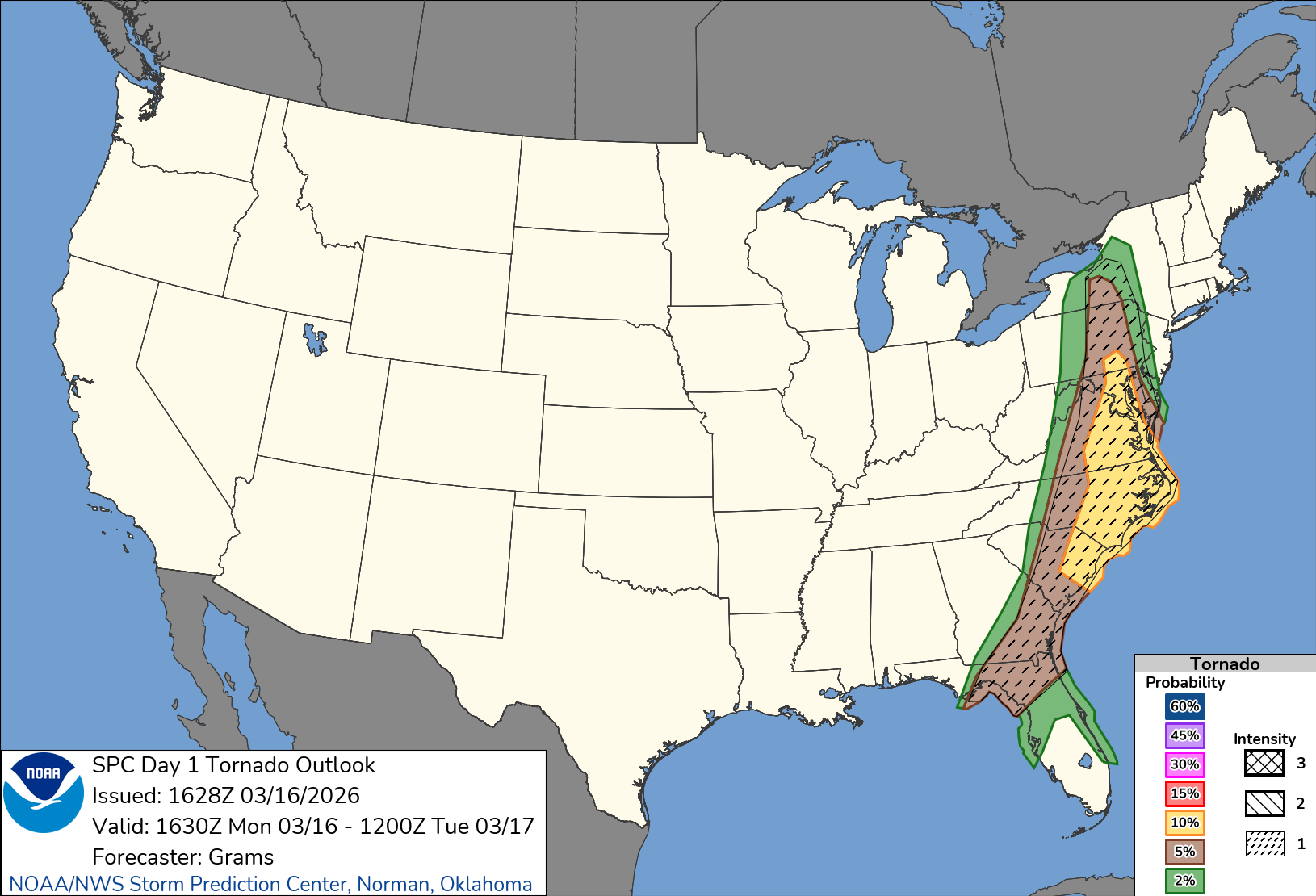
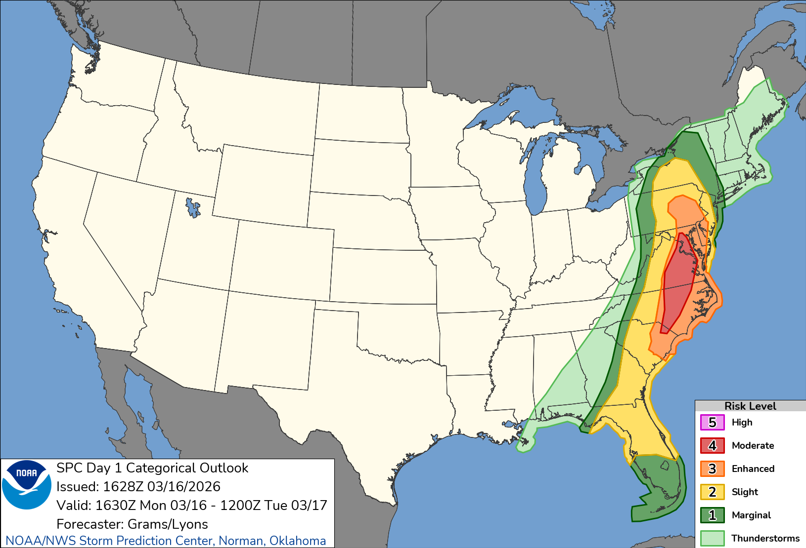
...THERE IS AN ENHANCED RISK OF SEVERE THUNDERSTORMS OVER MUCH OF THE CAROLINAS...VIRGINIA...AND EXTENDING NORTHWARD INTO SOUTHERN PENNSYLVANIA... ...SUMMARY... Widespread damaging winds and several tornadoes are forecast on Monday for parts of the Mid Atlantic and Southeast. ...Discussion... A large and deepening upper trough will eject east/northeastward out of the MS/OH/TN Valleys and across the Appalachians and into the Mid Atlantic/Northeast on Monday, with an expansive area of strong wind fields aloft. A surface low move from Lower MI into southern Quebec, with a deep pre-frontal trough extending southward across eastern PA, VA, and NC by around 21Z. Ahead of this trough/front, southerly winds will bring 60s F dewpoints as far north as southeast PA. Storms will likely be ongoing along the length of the cold front, roughly from OH to the FL Panhandle Monday morning. Given the uncapped air mass over the Carolinas, a few storms, possibly supercells, may develop relatively early in the day as well, with tornado potential. The greatest threat however will be during the afternoon as cold front nears, and pressure falls are maximized along with daytime heating. A few supercells ahead of the line will be possible, along with embedded circulations and/significant damaging winds within the squall line. There are model differences regarding the speed/position of the cold front, as well as the degree of instability. Regardless, damaging winds over a large area appear likely, along with at least a few tornadoes. Depending on the degree of destabilization, a strong tornado or two may occur especially over parts of the Carolinas and Virginia during the late afternoon. Many models forecast 300-500 m2/s2 SRH, along with pockets of SBCAPE over 1000 J/kg, which is clearly favorable for tornadic supercells. -
80 Degrees to Ripping Snow: March 12th
AmericanWxFreak replied to SnowenOutThere's topic in Mid Atlantic
Back end really pushing through. We’re gonna bust low for sure. GFS sucks. . -
80 Degrees to Ripping Snow: March 12th
AmericanWxFreak replied to SnowenOutThere's topic in Mid Atlantic
See you tomorrow. -
2026 Mid-Atlantic Severe Storm General Discussion
AmericanWxFreak replied to Kmlwx's topic in Mid Atlantic
Additional photos from this evening - one of the best storms in the last two seasons of living here.- 260 replies
-
- 17
-

-
- severe
- thunderstorms
- (and 7 more)
-
2026 Mid-Atlantic Severe Storm General Discussion
AmericanWxFreak replied to Kmlwx's topic in Mid Atlantic
Collapse with entrapment in Marriotsville down the road from me- 260 replies
-
- 2
-

-
- severe
- thunderstorms
- (and 7 more)
-
2026 Mid-Atlantic Severe Storm General Discussion
AmericanWxFreak replied to Kmlwx's topic in Mid Atlantic
Tornado warning here .- 260 replies
-
- 24
-
-

-

-
- severe
- thunderstorms
- (and 7 more)