

madwx
-
Posts
2,260 -
Joined
-
Last visited
Content Type
Profiles
Blogs
Forums
American Weather
Media Demo
Store
Gallery
Everything posted by madwx
-
Heavy rates to wind this one up but only about a half hour left of the snow
-
4.5” reported by family members about 15 miles NW of Madison. Around 3.5” here but tough to measure accurately in the city
-
light snow started here around 4:30. picking up in intensity with nice flakes. visibility below a mile
-
NAM and HRRR rending upward again. Getting a little bit hyped for this event
-
Things trending upward here. Think there will be some good rates from about 6 am through 2 pm
-
12z NAMs bring higher totals a bit further south into WI. Looking solid for 3-5" here
-
No in fact people have tried to argue the opposite, that solar minimums lead to more high latitude blocking and therefore PV disruptions.
-
What have your snow out days been the last few springs? Also I wonder how much liquid content is in that snow
-
still looking solid for 3-6" here. Only the NAM is not playing ball and even that is trending upwards. 12z Canadian shows the heaviest band heading into N Illinois. Gives Cyclone and Hawkeye a good hit
-
GFS with a very solid hit for N IA through S WI. Even Rockford gets 3-4” on this run. But it’s the GFS 72 hours out so who knows
-
12z Euro trending southward. Brings 3-5" snow totals to S Wisconsin
-
All of the models are consistently showing a swath of 3-6"+ for the northern half of the subforum from early Sunday through Monday, with the higher totals to the west and lower totals to the east as the wave weakens. The Euro is further N with the band of snow while the GFS, Canadian and UKMET are in the southern camp for now. GEFS mean looks solid for N Iowa, S Minnesota and Wisconsin.
-
37.4" of snow here on the season. 8.1" in Oct, 7.6" in Nov, 2.9" in Dec and 18.8" in Jan.
-
Tied for the 10th warmest January at MSN
-
record high broken both at 11 am at MSN and MKE. Up to 50 here with a couple more hours to increase the temp. the snowpack will survive this but it's definitely taking a hit
-
Record high of 47 in Madison about to go down as it was already 46 as of 9 am. Today is tied with 3 other days having the coldest record high temp so it was one of the easiest to break
-
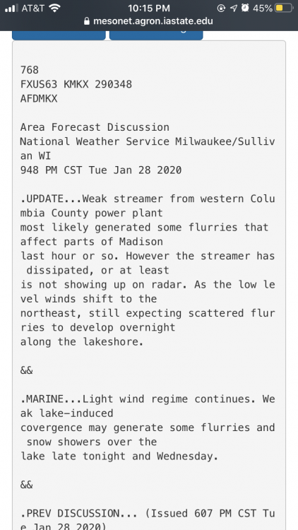
Here’s the AFD from Milwaukee describing it as well
-
Getting some power plant effect snow in eastern Dane county from the plant up by Portage
-
Madison is flirting with a top 10 warmest January of all time. Will need to average ~27.6 over the next 5 days to get in the top 10 and the point forecast has us averaging 27.7.
-
Luckily we have a few (possibly) silver linings: 1) its not guaranteed yet that a SSW will occur, only half of the GEFS have a warming occurring in the next 2 weeks 2) Not all SSW are the same and depending on how the vortex gets split/the alignment of the blocking we may not get brutal cold 3) By the second half of May, when prime storm chase season is occurring, the weather patterns are not really connected to any SSW occurring in Feb/Mar
-
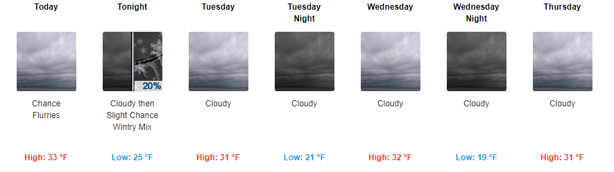
Such a gloomy forecast for the upcoming week. It's been awhile since we've had such a cloudy stretch on this side of the lakes.
-
Long range models indicating an increased chance of a SSW during the month of February. Defintely not set in stone but slightly concerning for people hoping for a warm early spring.
-

January 22nd-25th Winter Storm Potential
madwx replied to Thundersnow12's topic in Lakes/Ohio Valley
we're in the middle of what looks to be a 6-10 hour gap in snowfall on the west side of Madison. Definitely some slight melting of snow occurring. -
January 22nd-25th Winter Storm Potential
madwx replied to Thundersnow12's topic in Lakes/Ohio Valley
1.1" overnight but not accumulating that much on roads and sidewalks. Snow depth up to 6" this morning. -
January 22nd-25th Winter Storm Potential
madwx replied to Thundersnow12's topic in Lakes/Ohio Valley
Not sure how much we can add to the snowpack. things might compact as quickly as they accumulate and melting will be occurring during the daytime


