

madwx
-
Posts
2,138 -
Joined
-
Last visited
Content Type
Profiles
Blogs
Forums
American Weather
Media Demo
Store
Gallery
Posts posted by madwx
-
-
On 6/2/2019 at 12:20 PM, Spartman said:
June is probably going to be a write-off. With the highest temperature of the year so far at 88 degrees just over a week ago (May 25th), it's going to take until at least next month to try to exceed it.
6 hours ago, Spartman said:89'd today at DAY, highest temperature so far this year. Have a feeling it may be the highest it's going to get for this June.
I think you'll hit 90 today.
-
It’s crazy how much cool and dry air has been hanging around in the northern plains and Great Lakes so far this spring/early summer. Even during the big tornado stretch in May the temps in Oklahoma and Kansas n of the warm front were only in the 50s
-
18 minutes ago, The_Doctor said:
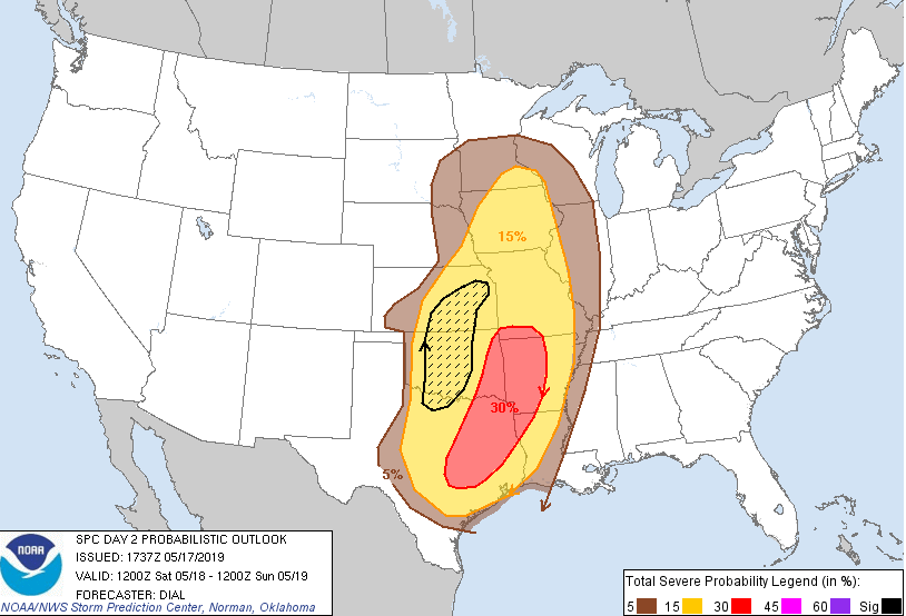
One of the odder looking probabilistic outlooks I've seen, with the sig area totally separate from the higher probs. This is the Day 2 outlook for tomorrow.
Yeah, has to do with an MCS moving through in the morning/early afternoon, which will be less severe but more of a sure bet to happen. And then a more conditional threat of supercells to the west which would have more significant severe.
-
going to be in Minneapolis this weekend and ironically might escape the snow being up north.
-
 1
1
-
-
HRRR wants to get a few fiesty thunderstorms up into S WI right along the warm front tomorrow.
-
 1
1
-
-
39 minutes ago, NegativeEPO said:
Been hearing some talk about a potential year without a summer actually transpiring this year. Is there much truth to that? It wouldn't surprise me tbh.
Pinatubo, Krakatoa and Yellowstone all erupting tomorrow. Decade without a summer
-
2
-
-
huge flakes in Madison, some are easily half dollar size or bigger. Already accumulating well on grassy surfaces.
-
Lol 3 feet of snow. April is the new December
-
 1
1
-
-
19 minutes ago, CheeselandSkies said:
Nice boomer just now, over at my gf's by Tenney Park. Wasn't expecting that today!
Sent from my SM-G955U using Tapatalk
Yeah, there were a couple of very vivid lightning strikes that hit the radio towers on the SW side of town. Probably tops most of the lightning I saw last year
-
some thunderstorms inbound to S Wisconsin and Illinois, will be nice to hear a couple rumbles
-
1
-
-
So many old piles of snow here. Some of this stuff will take weeks to melt
-
1
-
-
This is a fun topic. I'll put together some thoughts, not sure if it will be 10 or 20 or somewhere in between:
1) Jarrell, Texas 1997 - Some of the most complete damage of homes ever seen.
2) El Reno, Oklahoma 2011 - 1.9 million pound oil derrick was toppled and rolled 3 times. 20,000 pound truck was thrown over a mile
3) Phil Campbell, Alabama 2011 - F5 damage for much of its length. ground scouring, a car was completely destroyed and never found
4) Bridge Creek, Oklahoma 1999 - The infamous Moore tornado of 99, measured 318 mph winds
5) Smithville, Mississippi 2011 - Picked up an SUV and threw it a half mile into the towns water tower. all plumbing in some hones were either shredded or missing
6) Andover, Kansas 1991 - famous Andover tornado
7) Kellerville, Texas 1995 - This was only rated an F4 but the damage to a home was so intense that the surveyors missed it. Also ripped up multiple stretches of pavement. https://www.youtube.com/watch?v=-qmJOy0bxMQ (can be seenat 11:00 of this video)
8) Guin, Alabama 1974 - One of the longest F5 damage paths for a tornado
9) Goessel, Kansas 1990 - The second F5 for this supercell after the Hesston storm.
10) Plainfield, Illinois 1990 - Fujita said it was some of the most intense ground scouring he's ever seen
11) Bakersfield Valley, Texas 1990- Only rated an F4 but rolled 180000 pound oil tanks 3 miles and 600 feet up a hill
12) Stratton, Nebraska 1990 - also rated an F4 and fairly unknown but mangled farm equipment into balls and picked up mud from a lake and plastered it throughout the town(the pic below is of the incredible meso of this storm)
13) Philadelphia, Mississippi 2011 - 2 foot deep ground scouring
14) Brandenburg, Kentucky 1974
15) Wheatland, Pennsylvania 1985
16) Barneveld, Wisconsin 1984
17) Loyal Valley, Texas 1999
18) Jordan, Iowa 1976 -
19) Mulhall, Oklahoma 1999
20) Greensburg, Kansas 2007
-
2
-
 1
1
-
-
overachieved slightly up to 36 today. Excited for the 50s and possible thunderstorms this week.
-
1
-
-
Up to 34. First time above freezing since Feb 24th. The good news is that above freezing highs are forecast for the next 7 days.
-
2
-
-
12Z GFS trended SE and weaker with the low. Bring the rain snow line into southern Wisconsin
-
1
-
-
down to -10 this morning in Madison, breaking the old record of -9. Should be the only record we break during this cold snap.
-
1
-
-
Looks like we will be approaching the record lows on Sunday, Monday and Tuesday of -8, -9 and -12 respectively. As of right now record low maxs seem just out of reach, but the all time record low max for the month of March is 0.
-
If it's March 15 and were still having high temps 20 degrees below average I'll start posting in this thread
-
1
-
-
March looks to start out cold and (maybe) active. Have a feeling that after the next two weeks most of us will be howling for spring.
-
1
-
-
32 here so pretty heavy rain that is freezing on cold sidewalks. but the roads are mostly ok
-
2
-
-
12Z NAM bumping back west, with the heavy snow band lining up through Waterloo and La Crosse.
-
got down to at least -5 at 7 am this morning. May have squeaked out a -6 in between hours. Already up to 7 two hours later.
-
1
-
-
overachieved at 5.7" here
-
1
-
-
WWA hoisted for southern Wisconsin. Expecting 3-4" here over an 18 hour period
-
2
-
June 2019 General Discussion
in Lakes/Ohio Valley
Posted
Rochester, Mn has already had their wettest June day on record and they got all their precip before 6 am.