

madwx
-
Posts
2,280 -
Joined
-
Last visited
Content Type
Profiles
Blogs
Forums
American Weather
Media Demo
Store
Gallery
Posts posted by madwx
-
-
5 minutes ago, Baum said:
ring of fire pattern....please?
Check back at the end of June
-
58 minutes ago, beavis1729 said:
It’s due to increased testing. There could be some other ancillary reasons, but increased testing is the simplest explanation. Occam’s Razor.
yeah we are only catching 10% cases so in most states the rate of cases is just the amount of testing. A better method of seeing how many people are infected in each state is to count the deaths and assume the fatality rate is around 0.5-0.7% and calculate the cases from that.
-
19 minutes ago, RyanDe680 said:
He mentioned during some press conference this week (can't remember which) that the modeling did, but I don't think at that rate - something more in the 10k range.
Still confusing to me how these number continue to go up despite the soon-to-be 6 week lock down on a virus that supposedly takes 14 days max to show symptoms. Something tells me that the 14 day thing is way off.
I think a lot of the current spread is in places that people aren't able to social distance (prisons, work at meat packing plants, health care workers, etc.)
-
27 minutes ago, RogueWaves said:
"Are we setting ourselves up to face even a bigger onslaught of Covid cases, too?"
No. We are being set-up. Need to reach herd immunity asap to minimize the damage. Hope you enjoyed life as you knew it.
How do you propose infecting 80% of the population asap without massively overloading the hospital system. 20% of NYC got infected over 2 months and their system was on the brink of being overloaded.
-
 2
2
-
-
7 hours ago, Hoosier said:
Looking at the number of cases by county for Indiana, the more populated counties really stand out.

But looking at cases per 10,000 residents reveals some additional counties getting hit pretty hard that are not so obvious on the first map. One of the striking examples of that is in the northwest part of the state where Lake county has 1346 cases and the county directly south, Newton, has 40 cases. Yet it is Newton that has a hair more cases per 10000 people. Many of those cases in Newton county are at a nursing home.
Another thing that stands out is the very low number of cases in Tippecanoe county/Lafayette area. Even with clearing out Purdue, there is still a pretty sizable population there. And the testing rate per 10000 people there (blue map below) has been better than many other counties in the state.


the infection rate map mostly mirrors the testing rate map which is a good indicator that we're not catching all the cases
-
looking like a trend to a weak la nina as summer goes on and atlantic/gom temps are above average. Wonder if we will have a couple tropical systems impact the midwest
-
1
-
-
26 minutes ago, Hoosier said:
Cuomo announcing some interesting antibody test results from NY. In the initial round of testing, about 14% came back as having the antibodies. Wouldn't necessarily extrapolate that number across the country for various reasons but gives more credence to the idea that there are a large number of infections being missed.
that would mean the actual infections have been about 10x the reported infections, if not slightly more.
-
1
-
-
25 minutes ago, hawkeye_wx said:
Models have backed off of any cold, here at the west edge of the subforum, into early May. A few days ago they had a strong, wet system holding us in the 30s and 40s Saturday, but now that system will be more progressive and we should reach the 60s. The latest Euro has 60s and 70s every day except one through day ten.
Yeah definite trend upwards with temps, also no lows forecast below 36 in the point so the last freeze may have already happened here.
Also dewpoints don't look to drop below 20 any more which my skin will definitely appreciate
-
3
-
-
this weather must be how winter weenies feel when it’s in the 70s in late November
-
Snow showers tonight. The winter that never ends. Can’t even buy an above average stretch for the next week or two
-
1
-
 1
1
-
-
increasing evidence that Hydroxychloroquine has either no effect or a slight negative impact on patients being treated with it:
https://www.medrxiv.org/content/10.1101/2020.04.16.20065920v1
-
 1
1
-
-
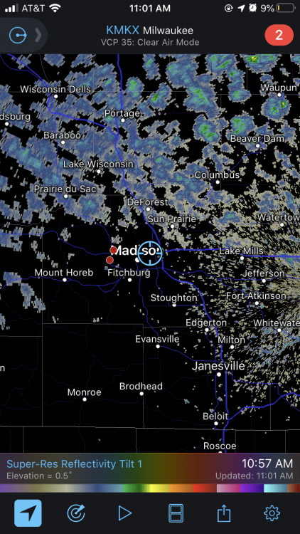
2 minutes ago, CheeselandSkies said:
@madwx @Geoboy645 Here's hoping for a few rumbles this evening, am I right?
'yeah, looking good. may head out to find a nice view to the NW and watch them roll in
-
1
-
-
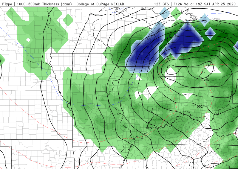
Hard pass. also i can't imagine there would be enough dynamic cooling at noon on april 25 to change the column over to snow.
-
1
-
-
1 minute ago, weatherbo said:
I'm getting grumpy in my old age, I have less and less tolerance for April. Waiting on the snow to melt and for it to warm up seems endless this year. When was the last AN April?
 A slight chance of snow showers before 9am, then scattered rain showers after 4pm. Mostly cloudy, with a high near 45. West wind around 15 mph, with gusts as high as 25 mph. Chance of precipitation is 30%.TonightScattered rain and snow showers before 9pm, then a slight chance of snow showers after midnight. Mostly cloudy, with a low around 19. North wind 10 to 15 mph, with gusts as high as 25 mph. Chance of precipitation is 30%.TuesdayMostly sunny, with a high near 32. Breezy, with a northwest wind 20 to 25 mph, with gusts as high as 40 mph.Tuesday NightA 20 percent chance of snow showers after 2am. Increasing clouds, with a low around 17. Northwest wind 5 to 10 mph becoming southwest after midnight.WednesdayA 20 percent chance of snow showers before 2pm. Mostly cloudy, with a high near 35. Southeast wind 5 to 10 mph.Wednesday NightMostly cloudy, with a low around 24.ThursdayMostly cloudy, with a high near 42.Thursday NightMostly cloudy, with a low around 28.FridayMostly sunny, with a high near42.Friday NightMostly cloudy, with a low around 28.SaturdayPartly sunny, with a high near 42.Saturday NightMostly cloudy, with a low around 28.SundayPartly sunny, with a high near 41.
i feel ya. It seems like the past 3 or 4 aprils have featured tons of NW flow with below normal temps. it would be nice if we could get some more zonal or sw flow and get some warmer temps and higher dewpoints in the area.
-
1
-
-
5 minutes ago, WestMichigan said:
What is up with all the name calling in here. Anyone who doesn't agree with the stay at home order is a moron, idiot, <insert derogatory name here>. We can disagree buy why all the name calling?
the only person that's been called a moron and idiot in the last 5 pages is the governor of Florida. I don't see any other name calling recently and everyone seems civil.
-
5
-
 1
1
-
-
30 minutes ago, Snownado said:
It's contagious but most people don't even get any symptoms. So im not sure what the panic is. The death rate is most likely well under 1%. I say open everything up and lets get back to living life again. And since outdoor activities is not very dangerous due to the virus not liking sunlight, im hoping baseball will start back in the next month or so.
its not the number of deaths that's the scary part its how easily it could overwhelm the hospital system, its why we are doing this.
-
2
-
1
-
-
10 minutes ago, Hoosier said:
Has anyone been able to find hand sanitizer? I seriously think I'd have a much better shot at striking oil in my backyard right now.
bought 2 bottles on February 23. Probably the best purchase i made this year
-
20 minutes ago, Snownado said:
I know it sounds crazy but there are people out there who would be ok with shutting everything down for the next year if it meant saving lives. Of course they don't think about the negative effects it would have, they are just focused on one side of the equation. We would probably all die from starvation by then. At some point you just gotta say screw it. Im going and living my life. If I die then I die. I'd rather die than live in a world of hopelessness and suffering that lasts for the decades.
how about we make some sacrifices for the next year but don't shut everything down. both the 'shut everything down' and the 'screw it im gonna live my life like i used to' points of view are unrealistic and will cause the most damage. if we have continued social distancing, good hygeine measures, markedly increased antibody testing, no large gatherings like sporting events and concerts and shorter periods of stricter methods if any areas become hotspots then we don't have to choose from the false dichotomy that you've presented.
-
3
-
-
4 minutes ago, KokomoWX said:
Those who support the stay at home order, how far are you willing to keep it going? June 30th? Labor Day? January 2021? I'm just asking.
May 15 with a slow phase in after that, then maintaining a baseline of social distancing for around next year. Any time we can buy to get better treatments/therapeutics more widely available is essential. We've done a pretty good job flattening this first wave but we need to be prepared for waves to come again later, especially if we relax social distancing too much.
-
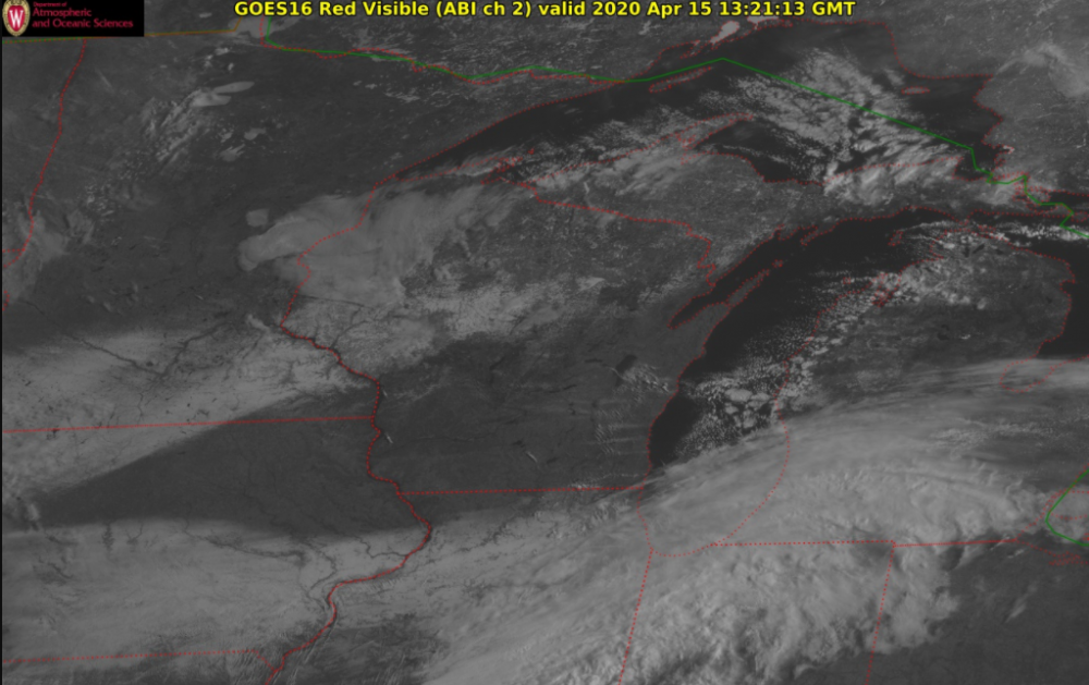
1 hour ago, A-L-E-K said:
i think we're going to get a cool visible sat show later from goes16 when it clears out and the stripe of accums is visible
looking pretty good already. you can also see some lake effect clouds off the Madison chain of lakes, Lake Winnebago and even the Mississippi River
-
2
-
-
5 minutes ago, RobertSul said:
Alcohol Withdrawl can be a serious and even life-threatening acute disorder, definitely not something you want tens of thousands of people going through at the same time, which would then lead to an additional strain on our hospitals.
The lottery provides funding for our schools and should be moved to online.
Fast food drive-through is a quick, easy, cheap, efficient way to provide food for people who don’t have cooking at home as an option, especially those working extremely long shifts at hospitals, first-responders, etc.
yeah unfortunately fast food is one of the only options for lower income people who are working extended hours during this time, and agreed on alcohol withdrawal. I don't think people realize how many americans are physically dependent on alcohol
-
1
-
1
-
-
17 minutes ago, Floydbuster said:
Since I'm less seasoned in winter weather, what do the odds of snow look like for Northern Ohio? I have people going nuts thinking a blizzard is coming in 48-72 hrs.
looking like no snow except for some snow showers possible during the week
-
been a couple flurry storms so far, 40 mph + gusty winds precede each one and blow the neighbors lawn furniture around a bit. strongest one of the day about to hit here
-
1
-
-
Snow showers imminent. Winds getting very gusty outside


2020 Short/Medium Range Severe Thread
in Lakes/Ohio Valley
Posted
i'll be out if anything tracks into S WI, gotta get my storm chances in considering I most likely won't be able to go to the plains to chase this year