

madwx
-
Posts
2,138 -
Joined
-
Last visited
Content Type
Profiles
Blogs
Forums
American Weather
Media Demo
Store
Gallery
Posts posted by madwx
-
-
The trend downward here continues on the GFS. Still warning criteria but losing about 2” per run
-
Just now, ChiTownSnow said:
Based on Kuchera tho I've never held much stock in that.
Kuchera is actually better than the standard 10:1 because its actually showing lower ratios which are much more realistic for this storm,
-
 1
1
-
-
3km NAM is a bit healthier into Southern Wisconsin
-
2
-
-
Some areas with Winter Storm Watches in Wisconsin get 0 snow with the 0z NAM
-
 1
1
-
-
from 11.1" to 0.7" in 2 runs of the NAM. Pretty impressive I must say
-
1 minute ago, Hoosier said:
To add to this, I believe that is the case for 500 mb heights. Not sure how it compares in other aspects.
Here is surface temps which shows a similar pattern.
-
1 minute ago, StormChaser4Life said:
Does anyone even follow or believe anything that model shows? Lol
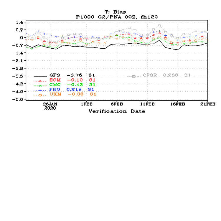
It has much better verification scores than the GFS and is only slightly worse than the Euro.
-
2
-
-
GFS still north. but trend in less snow here is obvious. from 10.1" to 8.9"
-
5 minutes ago, Chicago Storm said:
lol WPC disco...
19z update: The UKMET remains too far south and the CMC elongated more positively in the orientation of the trof Wednesday to delay it even further with very little/no interaction out of the Arctic stream to continue rejecting the UKMET/CMC from any preference at this time. The 12z GFS remains steadfast to continue to heavily favor it in the blend. The 12z ECMWF continues to be generally weaker with the inner core of the developing upper low/hub coming out of the MO Valley, keeping it south and east compared to the GFS/NAM and even compared to the GEFS/ECMWF. Interestingly, the Arctic shortwave continues to trend sharper/further south in all guidance. So will not break from initial preference, of the 12z GEFS/GFS/NAM/ECMWF and 00z ECENS through 26.00z and remove 12z GFS afterward weighting heavy to GEFS.
This is probably the reason all the offices are going with such high totals and watches
-
NAM went from 11.1" to 4.7" here between the 12z and 18z run
-
Just now, Stebo said:
I wouldn't have. Trends are big time going in reverse there.
the text for the watch is 7-12" for MSN. That's just taking the GFS straight and disregarding any other guidance
-
1
-
-
Lol MKX going WSW for most of the CWA. Not sure I would have done that
-
1
-
-
Trending toward DAB to 2” here. Will just have to see if the GFS falls in line
-
my second post call is still in play. We will see what the euro shows
-
if Madison gets 14” I’ll eat a hat. But actually this is looking good for a high advisory low end warning criteria snow here. Will be interesting to see if any other models folllow the ukmet in shutting us out
-
2
-
-
22 minutes ago, hawkeye_wx said:
That's exactly what I thought. At first glance, it looks like your typical "southern Iowa is mild, northern Iowa is cold behind the front(or still stuck with deep snow)" map, but then you realize the "cold" is 60º.
Yeah late February 2017 was very impressive in terms of widespread warmth. Like a mini March 2012
-
1
-
-
1 hour ago, hawkeye_wx said:
This was the temp map three years ago. Ottumwa nearly hit 80º, which is insane for February.
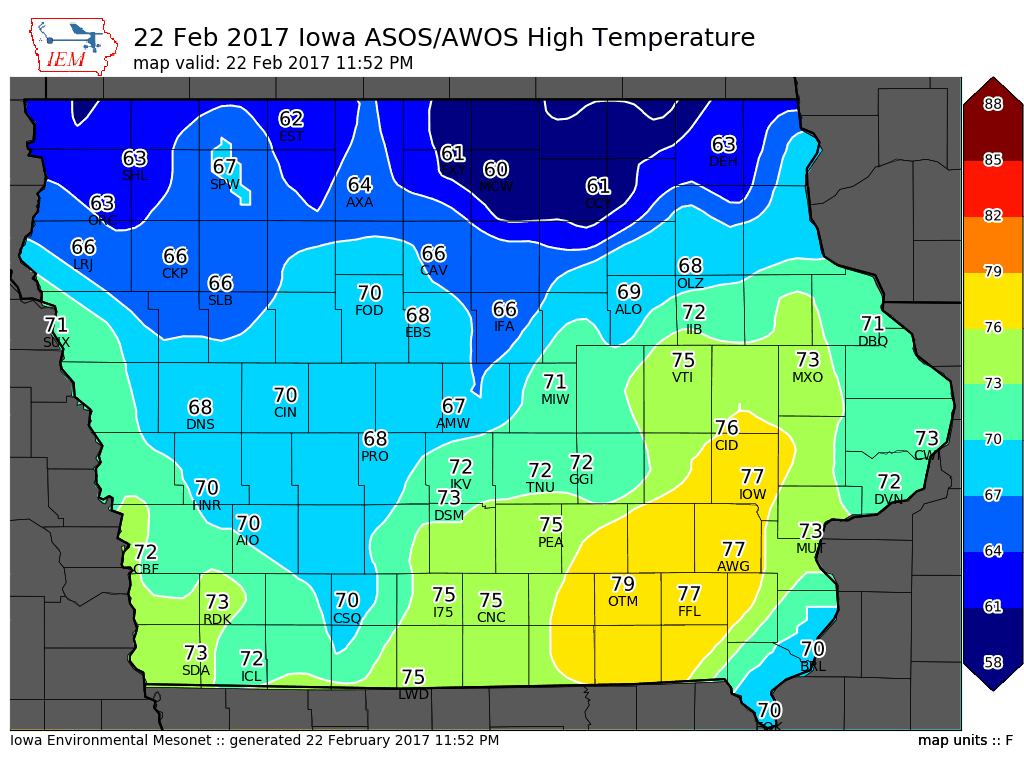
I’ve never seen a more misleading dark blue on a temp scale
-
3
-
-
4 minutes ago, A-L-E-K said:
Given the performance of the op gfs and the eps strength, feel p good about tossing the gfs imby. Would be a bad time for it to be right for once.
Yeah the upper level evolution of the Euro and some of its ensembles that I’ve looked at seem to make more physical sense than what the gfs is showing
-
This is a complicated pattern and there are numerous ways this can evolve. Depending on how strong the first and second waves are and the timing between the two. 6z GFS is probably the upper limit here with the second wave coming in further north and deepening the original low substantially. I also wouldn’t mind a better hit further south since we’ve gotten our fair share of snow here and the weenies down south could use a nice storm
-
3
-
-
21 minutes ago, hlcater said:
Hopefully we get an SSW in mid March so we can have more chances at snow in April.
A bit off topic but this vortex isn’t going anywhere any time soon. A good analog is 1997 and the stratospheric final warming didn’t occur until April 30.
-
1
-
-
Will enjoy the cirrostratus canopy
-
1
-
 1
1
-
 2
2
-
-
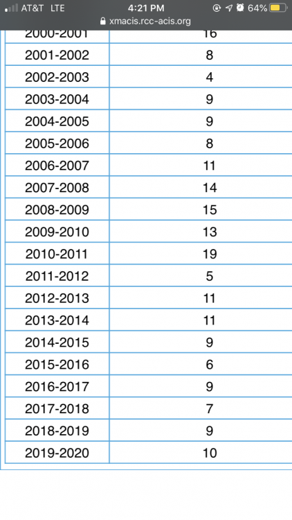
Here’s the max depth of the past 13 or so winters. Can really see the hot streak we had from 2007-2011
-
2
-
 1
1
-
-
45 minutes ago, Geoboy645 said:
Has it been that long? I could've swore we have had deeper depths like after the 2012 blizzard or last year.
In Dec 2012 the depth got to 11", deepest last year was 9" in early February
-
13” snow depth in Madison this morning. Deepest snow cover since GHD1
-
4
-

Mid-week potential of something somewhere
in Lakes/Ohio Valley
Posted
Eh we've been pretty lucky overall this winter with a few overperformers and deep snowcover for about the past month. Also my mind is switching to spring mode so by the end of this month I'm rooting for warmer weather and thunderstorms vs cold and snow.