

madwx
-
Posts
2,264 -
Joined
-
Last visited
Content Type
Profiles
Blogs
Forums
American Weather
Media Demo
Store
Gallery
Everything posted by madwx
-
Severe Thunderstorm Warning for the cell right on the nose of the MCV along the MN/IA border
-
Prairie Du Chien already up to 76/70
-
it was down for about 10 mins but it's back up now. at least on radarscope
-
these are elevated WAA showers so they aren't generating a cold pool. Surface warming already occurring in SW Wisconsin
-
Pros: MCV barrelling down the Iowa/Minnesota border, should reach here during the afternoon, ample moisture return Cons: All that convection between here and the MCV
-
As long as there is no festering convection in eastern Iowa in the mid morning I’m feeling prettay prettay good There's even some local backing of winds through late afternoon
-
the HRRR has been trending slower all day and its been the quickest model. Hoping the trend continues so storms erupt in our area
-
day 2 of some fiesty thunderstorms about to hit MSN. Looking like some small hail and 40 mph winds expected with these. can hear the thunder get louder as it approaches
-
Friday looking more and more interesting for S Wisconsin
-
some fiesty storms just passed through here. A pleasant surprise and am hoping for a repeat tomorrow
-
Man the pattern over N. America has been so amplified for the past month and a half.
-
dewpoint really mixed out today. Got down to 28 last hour
-
there is no scientific reason why the virus will be more deadly for young people in the future. In fact most diseases become less deadly as time goes on since the less deadly strains are more likely to spread. The 1918 influenza was abnormal in the fact that it became more deadly with the second wave
-
best summer climo
-
Down to 989.5 MSLP. should be a new June record for Madison
-
I think we need 990.2 to break the all time June record
-

Spring/Summer 2020 Medium & Long Range Discussion
madwx replied to Geoboy645's topic in Lakes/Ohio Valley
That's definitely not the case in the western lakes. Summers have been markedly wetter. Even in the eastern lakes precip trends seems fairly flat. MSN summer rainfall trends above for reference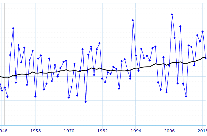
-
winds a steady 20 with gusts into the 30s now. first showers on the doorstep here.
-
Yeah the N/NW gusts behind the plains low are more impressive than the Cristobal winds right now. Must be great mixing conditions over there
-
all the CAMs have trended upward with rain in the Madison area this morning. The cirrus canopy is really overspreading the area now
-
based on my thoughts on how the shear will play out, I think the precip core for any cells will get shoved pretty far out of the way for any right moving cells. The strange backing with height is high up enough that it will really stretch out the updraft to the north, away from the track of the storm.. Think some days with nice VBV, except wonkier and probably really messy with low LCLs
-
both HRRRs have precip moving through S Wisconsin fairly quickly tomorrow, between 2-10, with a fairly convective look. Immediately afterwards winds turn to the SW and get very gusty into the overnight hours. The plains wave then moves eastward and that precip rolls in starting Wednesday morning. I'm looking at 3 periods for gusty winds tomorrow 1)ESE winds getting progressively gustier from around 9-2 tomorrow 2) any strong gusts brought down by convective features during the afternoon and evening 3) and perhaps the strongest winds behind the frontal feature after 10 pm.
-
snowing in Laramie, Wyoming right now if you thought our non-snow season wasn't short enough in the Midwest.
-
got 89'd here today. Feels like I'm living in Dayton
-
hi res models are on the east end of guidance and if they are correct we are going to get poured on


