madwx
-
Posts
2,264 -
Joined
-
Last visited
Content Type
Profiles
Blogs
Forums
American Weather
Media Demo
Store
Gallery
Everything posted by madwx
-
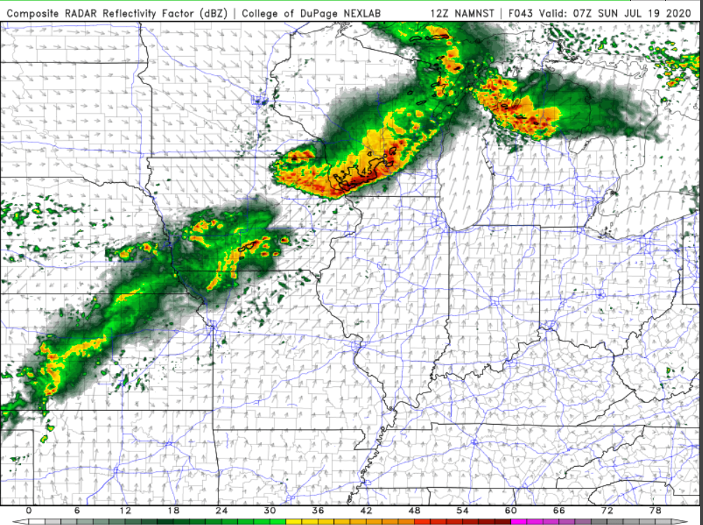
this mornings 3km NAM has a good handle on the current storms, just about an hour or 2 late with the development
-
I'm ready for the 2 straight hours of strobe like lightning

-
Saturday night is gonna be a dead on hit. Like the Summer nighttime MCS of yore.
-
dewpoint up to 70 already here. Hoping to crack some upper 70s tomorrow afternoon
-
Big differences between the HRRR and the 3kmNAM with the HRRR keeping both tonight's and tomorrow nights MCS much further north. The HRW suite seems to favor the further south propagation as well
-
Verbatim rolling into Northern Illinois between 4-8 am.
-
Really hoping we can find a way to tag 80 today. If so we should pretty easily be able to reach a top 5 streak of days above 80
-
New warning with the cell to the west. Tons of lightning with these things
-
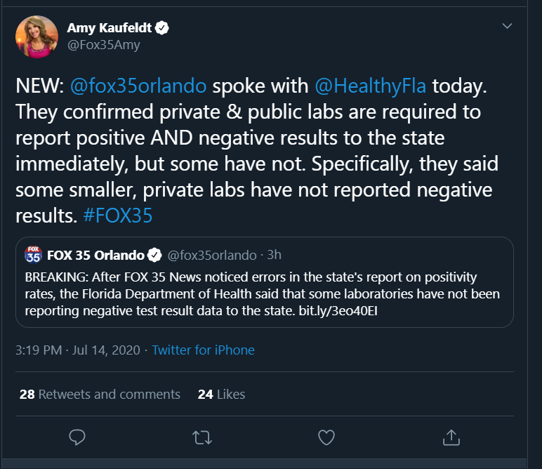
of course a group of people online have taken this as sign of a massive conspiracy. This reminds me of early on when Oklahoma was reporting only a tiny amount of tests and a very high positive rate because all private labs were only reporting positives. It made Oklahoma look like it was testing an order of magnitude people less than every other state ETA: confirmation of our theory
-
Crazy, just like watching the doctors slowly kill themselves in the operating room day after day. Not to mention the mass deaths in Asian countries from mask wearing. Not a time to trust the "experts."
-
Mr. Covid’s Wild Ride never ends
-
Gonna be very close to our normal July rain total already with rain only falling on 2 days this month
-
So much lightning with these storms. Gonna get a hefty rain total as well
-
Madison tagged 90 again today. 5 days in a row now
-
Saturday looking potentially interesting in Wisconsin on the NAM and 3km NAM.
-
we're going to have outflow boundaries galore over southern Wisconsin so that might be able to elevate some storms from an average t-storm day.
-
looks like another MCV/shortwave rolling along the Minnesota Iowa border through the afternoon and reaching Illinois/Wisconsin just after peak heating.
-
89'd for the 3rd time this month. Humidity is gonna take our 90s away this summer
-
looks humid, corn is gonna be chest high by the 4th
-
patterns like this make the CAMs look so foolish
-
yeah the airport might not get the super high amounts but the west side of town already has 2.5" plus
-
dewpoints cranking up to 75 here. really liking our odds of getting multiple days of dews over 80 later this summer
-
Even when the severe is mediocre we still do rain very well. 1.03” on the day and 4.82” on the month. Our new June climate average for 1991-2020 is going to be a crazy high value of around 5.3”
-
Yeah I’d kill for even a late night MCS with vivid lightning. The pattern has been really wonky this year
-
65 mph wind gusts with the severe warned cell