madwx
-
Posts
2,363 -
Joined
-
Last visited
Content Type
Profiles
Blogs
Forums
American Weather
Media Demo
Store
Gallery
Everything posted by madwx
-
Was an amazing day out. Got up to 69 at the house. Rest of the week should be beautiful too - in the 60s and 70s
-

Spring 2025 Medium/Long Range Discussion
madwx replied to Chicago Storm's topic in Lakes/Ohio Valley
thinking things will trend drier and warmer over the next 10 days but definitely some cool days mixed in, especially this week. looking at a change to SW flow and more active conditions around the 15th which should last through the end of the month (this is tied to indian ocean convection which climatologically flares up around this time - hence late May being a classic tornado stretch for the plains) -
up to 0.79" this morning with more showers throughout the next 2 days.
-
2025 Short Range Severe Weather Discussion
madwx replied to Chicago Storm's topic in Lakes/Ohio Valley
Storms were pretty intense this morning. Tons of cloud to ground lightning. Had 1” hail with the cells that formed behind the main bow -
I’ll give it a D. Had a pretty ok snowstorm in December. Had a couple bouts of snow centered around a week of deep winter in February that actually featured snow cover. One nice part was that it was sunnier than the average winter
-
Spring 2025 Medium/Long Range Discussion
madwx replied to Chicago Storm's topic in Lakes/Ohio Valley
the last 10 days of this month will be above average. also note that average temps are now pretty pleasant, so anything close to average will be 55 degrees or warmer -
Big bust. Just some sprinkles here but got much more sunshine than expected
-
Getting some unexpected filtered sunshine here. Gonna blast past forecast highs for today
-
Down to 15 here this morning. Should definitely be the last teens of the season. Also models are trending away from any measurable snow here tomorrow - which is a welcome change
-
flurries here currently. Today and possibly Wednesday night look like winter's last gasp here
-
That went about 2 miles from my house. Didn’t see anything interesting
-
Spring 2025 Medium/Long Range Discussion
madwx replied to Chicago Storm's topic in Lakes/Ohio Valley
cool/cold shot early next week. Then things turn mild around the weekend of the 12th. -
seems like generational happens every couple years now
-
10th warmest March on record here in Madison. have some cool shots coming up in April but not expecting a below average month
-
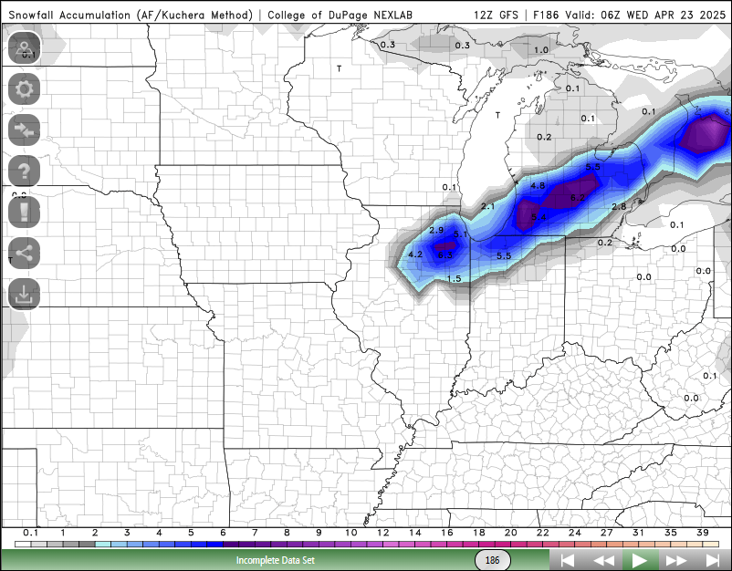
this thing keeps trending SE, almost enough to be interesting here on the winter side.
-
this storm is creating some pretty funning looking advisory maps
-
Insanely hazy out with the dust from Texas. Vis down to 4 miles
-
ummmm.

-
tied a 2012 morch record today. got up to 78
-
67 at MSN today. Breaking the record set all the way back in 1894
-
Up to 61 at the house today. First 60 of the season. MSN has a good chance to break the record high of 66 tomorrow
-
been pixie dust all day. slight accumulation on grass but nothing on roads
-
Hope everyone is enjoying their last day and a half of early model runs
-
Models are shifting the band north into our area. Need to turn the fans on to blow this southward