madwx
-
Posts
2,264 -
Joined
-
Last visited
Content Type
Profiles
Blogs
Forums
American Weather
Media Demo
Store
Gallery
Everything posted by madwx
-
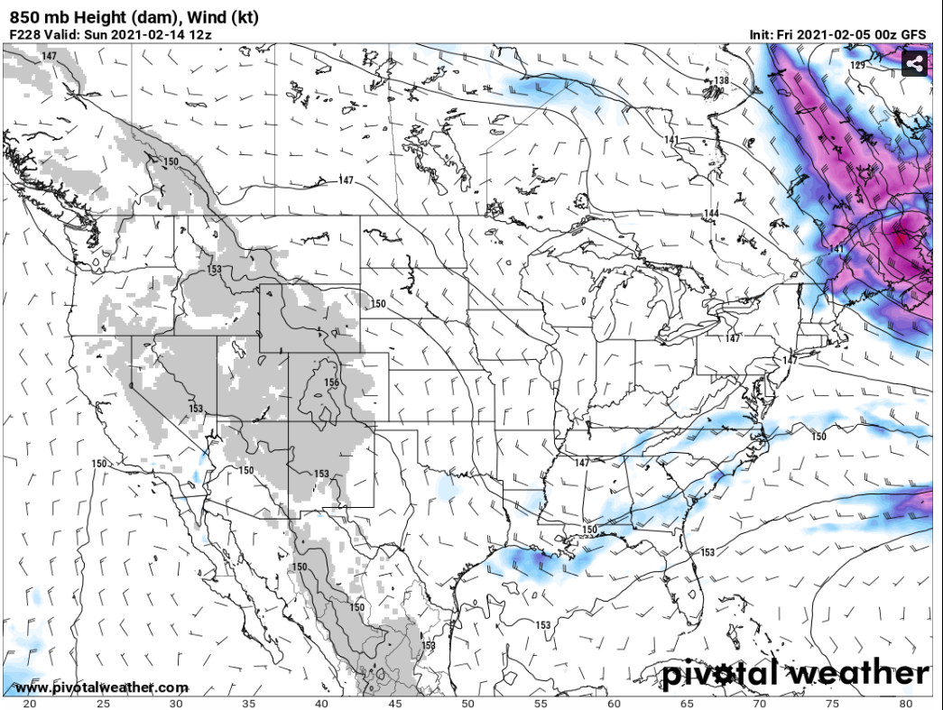
man the 0z GFS gets weird in the extended. By next weekend it basically sets up very little flow over the entire lower 48. the 850 mb level just stagnates and the cold air just sits over the entire country. Then afterwards we get a major chinook event and warm air floods in from the pacific

-
Winds gusting 35+ post frontal
-
winds were calm the past hour but pressure has started rising at the airport. Frontal band of snow with gusty winds is on our doorstep
-
looking like we could have 10 straight days with the temps staying below 20.
-
getting close to 3" now with a lull in precip. We'll have a couple more bands rotating through and then the front will be here. Winds are west at Mineral Point and NW at Prairie du Chien with a temp down to 27.
-
closing in on 2" on the ground here. Back edge about to race across the Mississippi
-
big flakes here. visibility down to a quarter mile
-
another thing to note is that the Stratospheric Polar Winds had their last reversal a few days ago and are now forecast to return to normal levels by mid-month. The tropospheric flow has been disrupted and the cold air will be dislodged for a while but there won't be any more stratospheric disruptions until the final warming later in the spring.
-
snow starting here. Fairly light right now but should be picking up shortly. Convective nature to the snow to our SW heading this way.
-
peeks of average to above average temps finally arriving around 2/17-2/19. Guessing people will be getting tired of the cold by then
-
mostly freezing rain here with a few sleet pellets mixed in. Sidewalks are slick but roads seem fine.
-
Getting some sleet here to start off the storm
-
Mixed precip about to start here with the initial waa band. The main show should start around 11 with heavy snow
-
This storm seems to be cutting more than the weekend clipper which allows nice storm totals to lift into the area
-
would be glad to welcome someone to the club
-
got an advisory for 3 to 6 with a glaze of ice and 35 mph winds post frontal
-
gonna lose track of which storm thread is which
-
still looking like a high end advisory total here(4" to 6") but the extra impacts mean we will probably get a warning. This thing has really sped up though. Most models have the snow getting out of here by around 9pm tomorrow night.
-
We're already starting to run into that in Madison, and with up to 10" coming in the next week it will become much more difficult. Especially with the brutal cold temps
-
will be interesting to see if these trend north and clip southern Wisconsin or if the PV pushes them south enough. The trend has seemed to be a bit northward
-
the second blast of cold air definitely looks stronger. Maybe getting a reprieve into the teens on Tuesday or Wednesday before it hits. All in all this is looking like a 10 day stretch of much below normal temps
-
got down to 0 this morning. about 8 degrees below the point forecast from last night
-
I move out of an apartment and into a house I bought at the end of this month. Will finally be able to get reliable snow and precip measurements
-
12z Euro has this in 2 waves now. The initial cold shot from Friday through Tuesday and then a reinforcement of cold air in the middle of next week
-
lol 558 heights over Baffin Bay