madwx
-
Posts
2,260 -
Joined
-
Last visited
Content Type
Profiles
Blogs
Forums
American Weather
Media Demo
Store
Gallery
Everything posted by madwx
-
An additional fun fact, with the snow depth remaining at 10" at the airport on the 28th, we officially had double digit snow depth the entire month
-
Ended up tied for the 12th coldest February here. The mild last week brought us warmer than 2014 and 2015. Snowfall was slightly below average(10.4" vs the 12.4" average) but precip overall was about half of average (0.8" vs 1.5" average).
-
Got 15 mins of nice aggregates about a half hour ago. Nice treat for my first night in my house
-
Agree to that last part. It’s been too low by about 8-12 degrees on the high temps the past 4 or 5 days
-
Today is the first day with over 11 hours of daylight here. Really noticing the earlier mornings now as well
-
after a brief colder shot early next week there are signs that the middle and end of next week could get downright mild, with 50s and 60s getting at least into southern Wisconsin
-
up to 41 already at 10 am. The point forecast high was just bumped from 40 to 44 here.
-
snow depth got up to 16" here this morning which should be our max for the season.
- 11 replies
-
- 2
-

-
- midwest
- season snowfall
- (and 2 more)
-
made it up to at least 37 today. Didn't reach our high until 5 and 6 pm. Point forecast only has us dropping down to 34 tonight with SW winds. Should help melting go through the night
-
clouds held on strong through the morning but the sun has started to break out within the last half hour. Expecting a jump into the mid 30s soon. It'll be our first time above 32 since January 21!
-
It's going to be real close to see if we end up colder than February 2015 here. If we do end up colder then it'll be the coldest February since 1936. We have to average colder than 26.3 over the next 7 days to be colder than 2015.
-
After a brief cold shot at the beginning of next week models are keying in on warmer than average temps flooding the region starting around the 3rd of March. Of course areas N of I80 will have to melt off a heck of a snowpack before the full warming potential can be realized
-
2.5” storm total at MSN
-
One last main band to roll through here. Estimating just under 2” on the ground
-
Surprisingly starting as sleet here
-
I feel like this is a natural time of year to have peak snow depth so I’m not too disappointed in it gradually starting to decline
-
Some lightning S of Omaha this morning
-
There’s going to be a countywide band of overperformance where a connective band sets up. DBQ area looks prime for that
-
The start time has been getting progressively later. Looking like mid afternoon around here. First call of 2”
-
Made it down to -5 here this morning which may be our last day of below zero temps this season
-
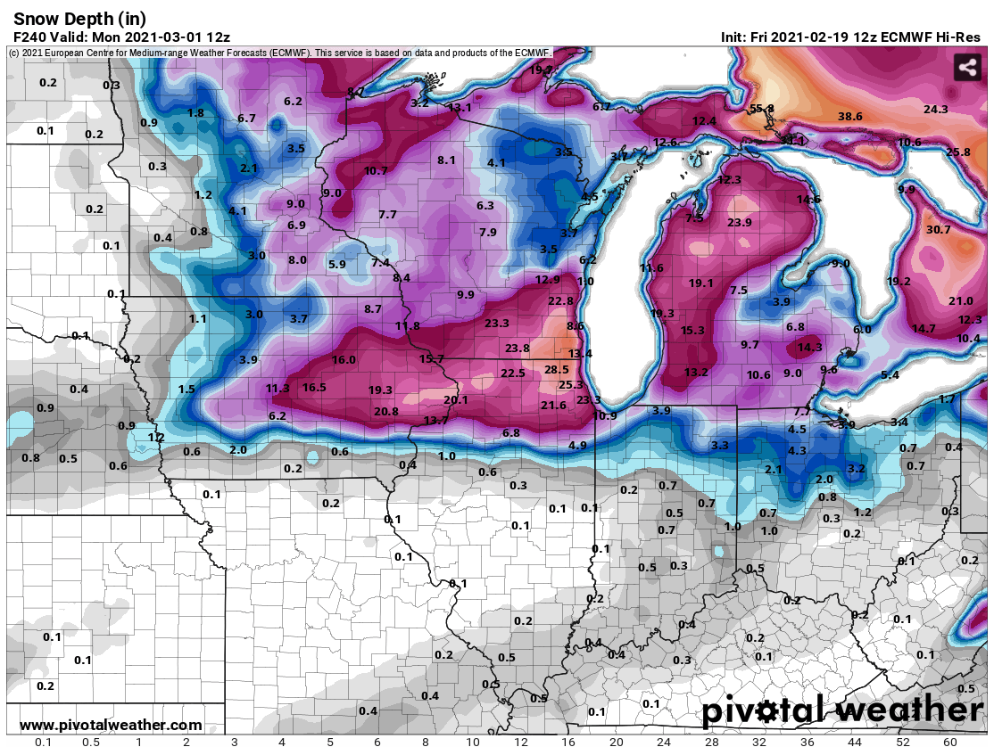
The Euro still seems to be doing horribly with snowpack modelling. It currently has us with 26" of snow depth, which is 12" more than we actually have. And by the end of it's 10 day run it only decreases our snow depth by 3" to 23" even though it has a week of above freezing temps(and only 1.5" of accumulation on Sunday). Just goes to show that even the king has modelling deficiencies.

-
March looks to start off with a Neutral/Positive AO/NAO and a -PNA. This should allow the SE Ridge to flex it's muscles a bit and bring warm air to at least the SE half of the subforum. An active storm track looks to continue though there may be periods of dry weather. There is a chance of a minor disruption to the TPV around the beginning of March but any cold blast would be short lived. Looking long range there will be a lot of snow to melt over the next month or two leading to increased flood risk. In addition the drought over the SW and plains is continuing which may allow a stronger EML to move into the region increasing severe weather chances.
-
Actually overperformed by a few degrees today up to 25.
-
getting some cumulus popping up here for the first time in a while.