madwx
-
Posts
2,264 -
Joined
-
Last visited
Content Type
Profiles
Blogs
Forums
American Weather
Media Demo
Store
Gallery
Everything posted by madwx
-

Jan 19-20: Hoosier is not allowed to start this thread
madwx replied to mimillman's topic in Lakes/Ohio Valley
Got the lure out. Maybe we’ll reel this one in -
Jan 19-20: Hoosier is not allowed to start this thread
madwx replied to mimillman's topic in Lakes/Ohio Valley
looks like we'll be riding the razors edge of any significant accumulation. Anywhere between T-6" looks possible -
CAA behind a deepening low with gusty northerly winds and we're still touching mid to upper 30s here today
-
The storm later next week piques my interest but overall I'm hammering the under
-
4th warmest first 10 days of January at MSN. only 1880, 1939 and 2007 were warmer
-
15.4" on the month and 20.2" on the season. The increase in snow totals just by gaining the degree and a half of latitude between us is always impressive
-
only 3.2" off. not a bad call for 3 days out
-
Looks like it could stack nicely overnight. These systems on the backend of cold snaps usually overperform. Final call of 3.2” here
-
got down to -13 this morning. up to a balmy -11. full sun here but the roads are still snow covered.
-
Dust Bowl incoming next summer
-
Pre-Christmas (Dec 21-23rd) Winter Storm Part 2
madwx replied to Chicago Storm's topic in Lakes/Ohio Valley
down to -5. Actually got to see the sun pop out right at sunset. Would estimate 5" or so but definitely impossible to get an actual measurement -
you know a zombie apocalypse wouldn't be short fuse
-
Pre-Christmas (Dec 21-23rd) Winter Storm Part 2
madwx replied to Chicago Storm's topic in Lakes/Ohio Valley
still snowing here, the snow has been pixie dust through the daylight hours but the roads are becoming increasingly horrible with the wind picking up Down to 1 F here. should head below 0 within the hour -
Pre-Christmas (Dec 21-23rd) Winter Storm Part 2
madwx replied to Chicago Storm's topic in Lakes/Ohio Valley
still snowing here. down to 3 degrees F. Wind chill in the negative teens -
Pre-Christmas (Dec 21-23rd) Winter Storm Part 2
madwx replied to Chicago Storm's topic in Lakes/Ohio Valley
Front already through here. Came through at about 4 AM Temp spiked up to 26 overnight. Back down to 14 with NW winds gusting up to 25 -
Pre-Christmas (Dec 21-23rd) Winter Storm Part 2
madwx replied to Chicago Storm's topic in Lakes/Ohio Valley
got a trace on the sidewalks and the roads through the first half hour. the snow is actually adding traction to the sidewalks. feels like I'm walking on sand out there -
Pre-Christmas (Dec 21-23rd) Winter Storm Part 2
madwx replied to Chicago Storm's topic in Lakes/Ohio Valley
we had a break after the drizzle/flurries earlier but now the synoptic snow is starting up with the initial wave. Very fine flakes. Off to the races -
Pre-Christmas (Dec 21-23rd) Winter Storm Part 2
madwx replied to Chicago Storm's topic in Lakes/Ohio Valley
it's like you're personally willing that front northward with your palms -
Pre-Christmas (Dec 21-23rd) Winter Storm Part 2
madwx replied to Chicago Storm's topic in Lakes/Ohio Valley
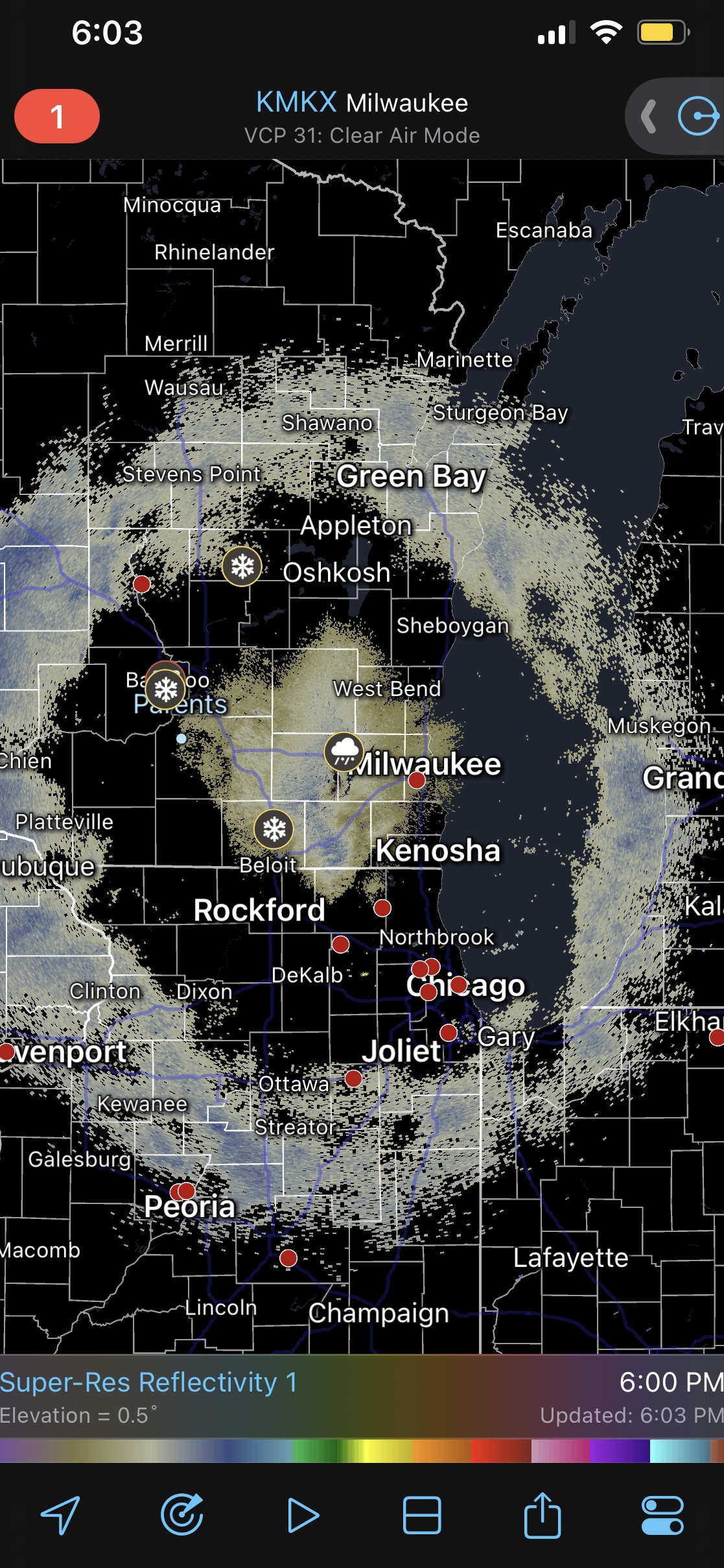
Pretty cool radar image with the system snow evaporating forming the outer ring and the flurries/drizzle only showing up close to the radar site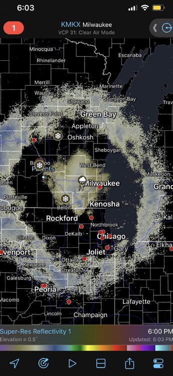
-
Pre-Christmas (Dec 21-23rd) Winter Storm Part 2
madwx replied to Chicago Storm's topic in Lakes/Ohio Valley
Same. Think we’ll be able to stack some nice dendrites overnight -
Pre-Christmas (Dec 21-23rd) Winter Storm Part 2
madwx replied to Chicago Storm's topic in Lakes/Ohio Valley
Temps are going to be around 10 when the snow starts falling here tonight -
Pre-Christmas (Dec 21-23rd) Winter Storm Part 2
madwx replied to Chicago Storm's topic in Lakes/Ohio Valley
First and final call of 6.4” and an upgrade to a blizzard warning at some point -
Down to -7 at the house. Second below 0 temp of the season
-
Pre-Christmas (Dec 21-23rd) Winter Storm
madwx replied to Chicago Storm's topic in Lakes/Ohio Valley
there's something strange with the COD 12Z GEFS output. Burying Illinois and Wisconsin with a huge amount of snow on Friday evening and Saturday morning with the low pressure moving very slowly. ETA: I think it is displaying the 12Z model run from yesterday, which explains why the low looks about 24 hours behind. -
Pre-Christmas (Dec 21-23rd) Winter Storm
madwx replied to Chicago Storm's topic in Lakes/Ohio Valley
This storm is looking very impressive for Michigan. Guessing most roads in the northern half of the state will become impassible on Friday.