jojo762
-
Posts
4,228 -
Joined
-
Last visited
Content Type
Profiles
Blogs
Forums
American Weather
Media Demo
Store
Gallery
Everything posted by jojo762
-

Central/Western Medium-Long Range Discussion
jojo762 replied to andyhb's topic in Central/Western States
Personally really like the setup on Sunday near the triple point in NW OK all three models show a conditionally volatile setup (pending mature supercells that break the cap)... The euro shows some convection, GFS shows very little, and the NAM currently shows none (albeit, it's the very end of the NAM's range). If anything does go in the progged environment it is likely to be significant severe, and given the wind profile should be supercellular and isolated. Monday presents a very tricky forecast, but there will almost certainly be severe storms, and possibly several tornadoes. -
Central/Western Medium-Long Range Discussion
jojo762 replied to andyhb's topic in Central/Western States
Given the differences between the GFS and euro it's a fairly low confidence forecast for now. But even the euro would feature a couple days of at least slight-risk caliber severe chances, obviously with various caveats and conditions. Whereas the GFS shows a fairly robust, but imperfect, setup along the "classic" I-35 corridor on sunday. -
Central/Western Medium-Long Range Discussion
jojo762 replied to andyhb's topic in Central/Western States
Euro looks pretty potent for next weekend as well. Frivolous to get into much detail, but looks fairly promising for a day or two of solid severe chances somewhere across the central/southern plains. -
Central/Western Medium-Long Range Discussion
jojo762 replied to andyhb's topic in Central/Western States
Definitely looks interestingly at this point in time. SPC provides a good take: "It appears that one or two short wave perturbations on the leading edge of this regime may dig to the lee of the Rockies and contribute to significant surface cyclogenesis anywhere from the southern Plains into the lower Mississippi Valley, and across parts of the Southeast, next weekend. Guidance remains suggestive that this could be accompanied by a fairly rapid and substantive moisture return off the Gulf of Mexico, providing potential for destabilization supportive of an increasing severe weather risk. Due to the rather large spread among the model output concerning these developments (associated with low pattern predictability and the extended time frame), severe weather probabilities for next Saturday/Sunday currently remain generally low, but it is at least possible that this could change during the coming days." -
Central/Western Medium-Long Range Discussion
jojo762 replied to andyhb's topic in Central/Western States
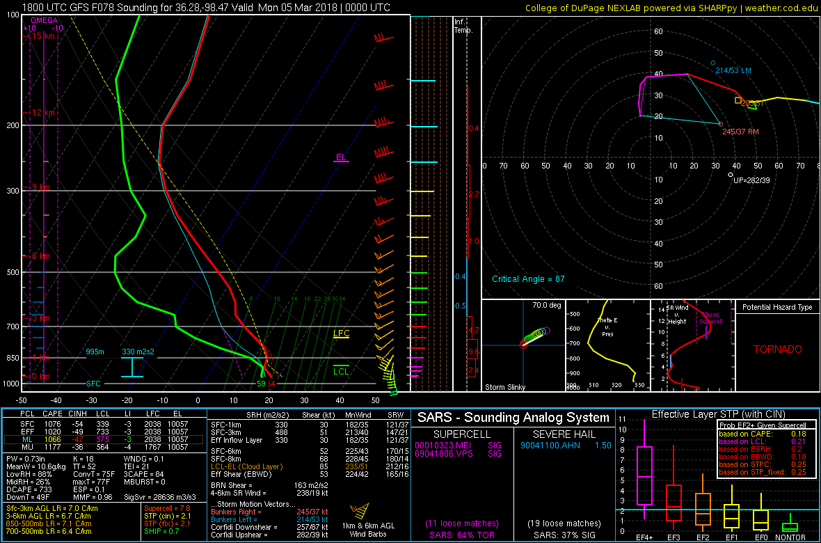
GFS seems to be slowly trending toward a tad better moisture return... Likewise forecast soundings on the 18Z GFS are seasonably impressive along a narrow corridor in close proximity to the dryline on Sunday evening from SW OK into SC KS, featuring an ideal hodograph for low-level mesocyclones and modest instability, not the best moisture quality obviously but probably do-able with the low LCLs, something of note is fairly respectable low-level instability which plays a significant role in tornadogenesis. This will be a fairly impressive early season setup (low/mod CAPE/ high shear) if we can just get a little more breadth to the axis of greatest instability. Not looking like an overly significant event attm, but definitely an interesting day for the beginning of March in the plains. BTW. this sounding is from just west of Enid at 6pm Sunday.
-
Central/Western Medium-Long Range Discussion
jojo762 replied to andyhb's topic in Central/Western States
Not sure why I mentioned overturning, misplaced some of the precip and VV maps in my head apparently while doing calc. Will be interesting to watch this evolve tonight, tomorrow and into this weekend. Any meaningful uptick in instability and moisture dramatically improves this system's prospects from what I can tell. -
Central/Western Medium-Long Range Discussion
jojo762 replied to andyhb's topic in Central/Western States
Perhaps I am over-emphasizing this in my head with the very strong mid/upr trough overhead providing impressive forcing for ascent, but the 100-120+J/KG of CIN in the GFS soundings at 00z Monday (6pm Sunday) sticks out like a sore thumb to me. If we were to just get a relatively minor 3 to 5-degree improvement in DPs from what the 18z GFS run already progs in addition to less downstream convective overturning from crapvection earlier in the day, we would have an entirely different conversation on our hands, that is if you take the extremely impressive kinematics verbatim. Wind fields will probably be there as both the GFS and EURO show relatively similar setups attm imo. The current extreme D3 drought over the area where the dryline is currently progged to be lends to some additional concern over moisture quality as well. -
MO/KS/AR/OK 2019-2020 Winter Wonderland Discussion
jojo762 replied to JoMo's topic in Central/Western States
What a difference a few days make... Just a few model runs ago we had a full on lee-side cyclone with a relatively strong band of frontogenesis to the north resulting in a nearly all-day snow event with an impressive band of snow (what could've been 6"+) somewhere across KS/MO, now we are left with no lee-side cyclone, a fast-moving open wave, and modest mid-level frontogenesis resulting in a few hours of snow with MAYBE 3" for someone, probably north of I70. Sad, after it had looked so good not too long ago. That's anything past 2011 for ya... -
MO/KS/AR/OK 2019-2020 Winter Wonderland Discussion
jojo762 replied to JoMo's topic in Central/Western States
Yeah, I ended up with 2-2.5" in Overland Park... accumulated fairly quickly within about 2 1/2 to 3 hours. Always great to go from expecting a dusting to getting a couple inches. -
MO/KS/AR/OK 2019-2020 Winter Wonderland Discussion
jojo762 replied to JoMo's topic in Central/Western States
The overall trend has indeed been for the heavier swath of snow to be a bit further south, but that specific run was a bit more dramatic with its shift and knocking down of totals. Likewise the very next run shifted back north. Probably won't have anything nailed down better until Monday night, or even Tuesday when we know where the best frontogenesis is occurring. As per usual with winter systems now, my expectations for this storm have gradually kept declining. -
MO/KS/AR/OK 2019-2020 Winter Wonderland Discussion
jojo762 replied to JoMo's topic in Central/Western States
The previous few days of GFS runs all showed KC getting a healthy amount of snow (3"+, something KC hasn't seen in four years)... then the 18Z run comes out and shifts everything further south. Probably just a weird run, but it is definitely odd to see such a shift in a <84 hour forecast. -
MO/KS/AR/OK 2019-2020 Winter Wonderland Discussion
jojo762 replied to JoMo's topic in Central/Western States
Wowzers. Not sure i'm really on board the hype train but 00Z GFS went all in on a big-league snow storm for NE KS/ N MO (including the entire KC metro) for Monday night/Tuesday. Widespread double digit totals. Pretty impressive run, to say the least. But if I have learned anything over the past few years, it is to take more of a tempered approach when it comes to model-output for snow... FWIW, 00z GEM also agrees on a decent snow event for generally the same area, but to a much lesser extent than the GFS. Probably worth noting as well that most of the 00z GEFS members disagreed with OP run on the idea of any kind of major event. -
MO/KS/AR/OK 2019-2020 Winter Wonderland Discussion
jojo762 replied to JoMo's topic in Central/Western States
It's still free on weather.us ... https://weather.us/model-charts/euro/significant-weather.html -
MO/KS/AR/OK 2019-2020 Winter Wonderland Discussion
jojo762 replied to JoMo's topic in Central/Western States
00Z GFS looks like an outlier run for how the trough develops (I.e., no cutoff). Not sure how to take it. Guess we'll see what the EC says later. -
MO/KS/AR/OK 2019-2020 Winter Wonderland Discussion
jojo762 replied to JoMo's topic in Central/Western States
Mike Morgan from KFOR already talking about the possibility of wintry precipitation on Christmas, 11 days away. Such a bad representative for mets everywhere, despite being in a state whose flagship university is known for meteorology. "LATEST LOOK at Christmas Day in OKC. This forecast is based on a LOT of different and constantly changing forecasts from about 150 computer models a DAY. General PATTERN of all of these COLDER with MOISTURE POSSIBLE. Still 12 days away but will track it." https://twitter.com/MikeMorganKFOR/status/941163647463813120 -
MO/KS/AR/OK 2019-2020 Winter Wonderland Discussion
jojo762 replied to JoMo's topic in Central/Western States
Basing off of the relative consistency of the GFS and Euro for the upcoming pattern i'm pretty optimistic about getting some harsh cold and possibly even snow at some point between next week and mid-december. Knowing how these things have evolved the past few years though it'll (the main system(s), whenever it comes through) probably devolve into 33 and rain. Time will tell, but definitely should be some interesting systems/setups coming up. -
MO/KS/AR/OK 2019-2020 Winter Wonderland Discussion
jojo762 replied to JoMo's topic in Central/Western States
lol 12z GFS shows a high-impact blizzard in Colorado and some light snow along the I-70 corridor in KS/MO by D7-8. That came out of nowhere. Verbatim the temp profile appears to support more a mix/very cold rain, but still something to glance at I suppose. -
Central/Western Medium-Long Range Discussion
jojo762 replied to andyhb's topic in Central/Western States
Well looking like our final legit chances in the central plains could be taking shape next week possibly into next weekend, still some timing differences between the euro/GFS, but appears there will be several opportunities for severe storms for at least the northern plains, but probably extending into the central plains on a couple days as well. EML is progged to be quite strong so that will play a big role in how things evolve, but prospects look fairly good with an unseasonably strong mid-level trough ejecting into the N/C Plains. After this period remains a bit uncertain ATTM... But currently leaning toward the inevitable, and dreaded, death ridge developing by ~June 20, likely ending any legit severe/tornado prospects for the central/southern plains for quite some time. -
Central/Western Medium-Long Range Discussion
jojo762 replied to andyhb's topic in Central/Western States
13 tornado reports during one of the most active periods of the year, typically. Only two of which were in the plains... eek. -
Central/Western Medium-Long Range Discussion
jojo762 replied to andyhb's topic in Central/Western States
Some hint from the GFS/GEFS that things could heat up a lot more somewhere cross the plains toward mid-month with appreciable SW flow and abundant moisture... so hopefully that pans out. Not quite in EC or EPS range yet. -
Central/Western Medium-Long Range Discussion
jojo762 replied to andyhb's topic in Central/Western States
This is somewhat reminiscent to 2013 imo as well, especially by Friday/Saturday, H5 map isn't exactly the same but has some similarities, notable differences being the presence of a large NE-trough this go around and the central CONUS trough isn't quite as strong, but other features are similar... Thursday looks mildly interesting, but thinking capping will hinder convective development, and therefore any potential it may have, as of now. GFS has trended with a weaker cap on Friday/saturday, so naturally given the progged thermo/kinematic profile, along with only subtle forcing, those days would both probably be fairly interesting if things were to evolve as shown now (doubtful)... We've all seen what these extreme instability/moderate shear environments have been capable of in the past... -
Central/Western Medium-Long Range Discussion
jojo762 replied to andyhb's topic in Central/Western States
I like our chances of seeing at least SOMETHING the end of this week/weekend... At least one day could be fairly impressive, depending on how a myriad of environmental factors evolve. CIPS GEFS analog percentage for Day 6-8 of at least 10 SVR reports. GFS for several runs has been moderately impressive -- to varying degrees, for a variety of reasons -- for Friday specifically, but Thursday and Saturday could feature severe storms as well. A bit too far out to determine potential hazards really, but the wind profile will be quite favorable for supercells with impressive veering with height.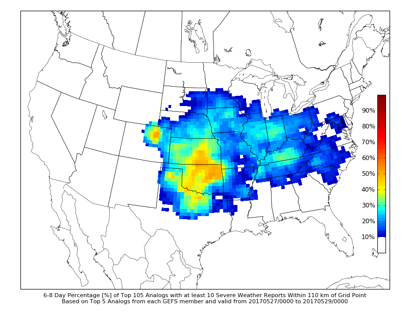
-
Central/Western Medium-Long Range Discussion
jojo762 replied to andyhb's topic in Central/Western States
OUN highlighting how models are starting to converge on at least modest, but potentially somewhat strong, W/SW flow atop moist/unstable environment for multi-day severe threat. -
Central/Western Medium-Long Range Discussion
jojo762 replied to andyhb's topic in Central/Western States
Somebody should go ahead and make a thread for this coming week 5/15-20/21 as it looks like we will have several days with severe possibilities with perhaps a big/interesting day or two mixed in. Tuesday continues to look like a highly volatile day, moisture is perhaps a little less than I would want (still mid/upr 60s DPs per GFS along the DL, a little less on previous euro runs though), but moderate/strong instability juxtaposed to a somewhat favorably timed strong mid-level jet streak coinciding with a strong LLJ of 35-50kts by 00z, could be quite a day. -
Central/Western Medium-Long Range Discussion
jojo762 replied to andyhb's topic in Central/Western States
Both the 00z Euro and 12Z GFS operational runs are in fairly good agreement on a fairly substantial threat developing along and east of the dryline across Western/Central KS and Western OK on Tuesday afternoon and evening with an impressive 35-50kt LLJ by 00Z and a 50-60kt mid-level jet penetrating the strongly unstable warm sector by 00Z... Both models, as you can imagine, show an impressive parameters space along with isolated, discrete convection by 21-00Z. Main difference between the two would appear to be the Euro showing VBV above 500mb, and the GFS showing no VBV. Don't have too much time to delve into any other details, perhaps someone else could add something more... Capping appears to possibly be an issue...