jojo762
-
Posts
4,228 -
Joined
-
Last visited
Content Type
Profiles
Blogs
Forums
American Weather
Media Demo
Store
Gallery
Everything posted by jojo762
-
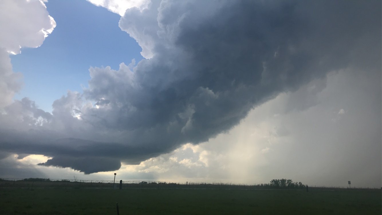
Was on this storm from initiation onward until it merged into a blob near sunset. Wrapped up really nicely numerous times, produced numerous dusty tornadoes that weren’t fully condensated. Really thought it was going to produce something more significant at least a couple times — but it never could quite get it going. RFD was quite strong, but perhaps not warm/moist enough — and the inflow wasn’t all that strong really. On to tomorrow which offers a wide range of targets... most of which are probably too far from Wichita Falls to actually chase. Looking like Sunday could possibly be the last “severe day” the plains have for a while.
-
Don’t know if even the current ENH risk area is far enough south, given how fast the OFB is surging southward.
-
Today was my first official day of my mini-chasecation. Made it to AMA this afternoon after staying the night last night in Edmond OK, and chased dryline convection down to near Hart TX. Storms struggled to get going, and nothing really got well organized — combo of weak shear and weak lift. Going to sightsee in the panhandle tomorrow morning then head to near Garden City, KS for tomorrow’s round of storms. Expect a decent amount more of organization out of tomorrow’s storms, nonetheless things could and probably will get messy pretty quickly. Friday and Saturday offer several potential targets (although they aren’t super far apart necessarily), and both days are looking pretty boom-or-bust attm. EDIT: actually after having looked at 00z guidance... I’m not so sure on garden city as a target. Gonna be a bit of a obs day.
-
SPC is interestingly bearish. Hardly even mentioning severe potential across the central/southern plains in the D4-8 time period. Very interesting, as models have consistently showed at least some potential in the Thur-sun time period.
-
Good luck! Potential for “better” more interesting chases later on in the week possibly. Don’t get too burnt out on driving by then Quincy!
-

Central/Western Medium-Long Range Discussion
jojo762 replied to andyhb's topic in Central/Western States
Looking like those long range ensembles from May 8th are going to verify. Looking at a multi-day period starting mid-week with severe potential along a lengthy portion of the high plains... followed by what will likely be several days of severe storm opportunities from Thursday-Sunday in the central and southern plains. Models diverge a bit on details and days of interest, so it’s hard to nail down many specifics. Good chance we don’t see any days delineated in tonight’s D4-8. For example, though, the GFS is more aggressive with Thursday and Saturday, while the Euro is aggressive with Thursday (in an area much further west than the GFS) and on Sunday. -
Was on the same storm as Quincy. Took me a while to leave my original target to go after it... but still made it just in time to at least get some structure w/ a wall cloud. As he stated, wasn’t very much rotation, but altogether not awful given my minimal expectations for the day.
-
Today features a chance for isolated tornadoes across SW IA. A surface low will be positioned near the IA/NE border by 00z, this low will gradually pull moisture poleward throughout the afternoon. Impressive low-level cape 100-150J/kg will exist to the southeast of the low this along with easterly SFC flow aiding in decent low-level hodograph curvature, marginal MLCAPE, and low LCLs could create a sneaky day for a couple of tornadoes across this area. Seeing as to how I’m only about two hours away, I think I’ll give it a swing. Not expecting much, but it’s a fairly short drive. Somewhat ironically last night I was thinking Clarinda, IA was a good target, and Jeff Frame on twitter actually posted this as his hypothetical chase target of the day.
-
What a totally awful and forgettable three day period this ended up being. 5/13: Weak shear, and strong CIN wrecked most updrafts between 20-00z... things picked up a little bit toward/after 00z with some okay structure in SW OK. 5/14: Again weak shear, and some mid-level subsidence wrecked most updrafts. A few updrafts were shortly pretty, toward 00z a few small, bizarre looking storms acquired weak rotation and produced brief funnels/possible tornadoes. 5/15: Weak shear and a surging outflow boundary totally ended any legit potential today. Looking like things are going to be quite boring in the central and southern plains the next week or so with a ridge setting up shop across the region. Perhaps the pattern begins to change toward next weekend, with potentially similar mesoscale-type setups. FWIW tomorrow in SW IA/SE NEB does not necessarily look awful. Biggest question will be in regard to moisture quality/instability. Low-level hodographs will be very impressive with strong veering. If trends continue to look up, might drive out there and see what Iowa can do.
-
Considered going to C/S OK today. But driving 1300 miles the previous two days has made me not want to chase a 2% day in OK that’s probably going to be a QPF bomb. Yesterday wasn’t too bad, chased until around 10:30pm. Got a beautiful LP supercell north of Emporia, KS followed by numerous funnel clouds/possible tornadoes in northern Lyon county toward/after sunset, went a bit East and got hit by 70-80mph winds from the cluster that formed. Only really got a decent picture of the LP storm, everything else had low-resolution due to darkness or just wasn’t worth taking a picture of.

-
Sitting in emporia KS... towers going up to the west. Don’t think they’ll sustain for now, but we shall see.
-
Seeing as to how I live in eastern KS, I’ll be out chasing today. Forecast soundings are impressive: extreme instability, impressive low-level moisture and CAPE, along with large low-level hodographs. Shear is normal to the boundary, which would generally favor supercells *but* bulk shear today is again on the marginal end of what you want, so things could get messy pretty quickly, or a storm or two could stay discrete for a couple hours of chasing fun. The amount of trees in eastern half of KS sometimes make it a little annoying to chase here. But nevertheless I expect much more out of any sustained storm than I expected yesterday in the E TX PH/W OK at the same time. We’ll see. Not superbly confident in CI prior to sunset. All other CAMs aside from the HRRR/HRRRv4/TTU-WRF show initiation after sunset.
-
Headed out to NW OK today... Might not be worth the five hour drive... but liking the dryline bulge/punch w/ 50kt jet core traversing the dryline ~21z in the OK PH, so we’ll see what happens.
-
00z CAMs largely struggled to sustain convection along the dryline, not too surprising given that they do not necessarily do the best in weakly forced environments. Most solutions do not agree with the NAM’s idea of a strong theta-e gradient along the KS/OK border, aside from the NSSL-WRF. Not a whole lot to say besides if supercells do go up along the dryline, they’ll probably be fairly intense given strong cape/low-level shear and able to sustain for several hours given ample moisture advection and orthogonal shear vectors.
-
Literally our first or second true dryline day of spring coming up in 48 hours and nobody is talking about it on here... amazing. Wx Twitter seems thoroughly convinced that Wednesday is garbage, I however am certainly not. Global models continue to indicate a particularly interesting day across OK and KS, NAM is out to lunch imo, at least to an extent... You’ll see the NAM off by 200 miles wrt warm front location before you see the Euro off by that much... several critical things to watch tomorrow, 1. 00z RAOB 850mb temps in SW TX (how strong is the cap going to be along the dryline?), 2. Temperatures/dewpoints tomorrow in SW OK... NAM says mid/upper 40s dewpoints in SW OK, other models say 60s dewpoints.
-
Still rather large spread in guidance WRT the potential wedge of low theta-e air across KS/OK on Wednesday — presence of such a feature would certainly put a high degree of uncertainty in how exactly the day/risks would evolve.
-
00z globals continue to show a considerable difference to the NAM... NAM seems to be trending a bit further north with the front, but is still notably a southern outlier. GFS continues to show what would be a fairly impressive environment in W KS/W OK, looking like an exceptionally chaseable day.
-
What do you make of the NAM’s warm frontal position vs globals. Kind of odd how much different it is... damn near 200+ mile difference.
-
I’m not so sure this will be the case... ample moisture progged by ECMWF/GFS/UKMET/CMC on Wednesday with 65-70 d/Tds common east of the dryline by 21-00z coinciding with 7-7.5 C/km LLVL lapse rates. Low-levels kinematically for this setup are essentially ideal, as are critical angles... my biggest concern is potential for rather weak/marginal 400-200mb winds, which won’t particularly aid in venting of rain out of the updraft.
-
ICT already discussing potential for tornadoes on Wednesday/Thursday in their AFD.
-
Probably could go ahead and make this thread for the 13th through the 15th, as Friday appears to have at least some severe potential as well attm. Probably not looking at a day with widespread outbreak potential necessarily, but certainly looking at a period that could end up having “Classic” May chase days, for sure. Wednesday looks fun, and I’m curious to see what the NAM ends up showing when it gets in range.
-
Central/Western Medium-Long Range Discussion
jojo762 replied to andyhb's topic in Central/Western States
00z GFS jumped on the bandwagon for next week as well... depicts two severe days across the plains on Wednesday and Thursday. With Wednesday possibly featuring higher-end tornado potential... stay tuned! -
Days like today are when it’s necessary to chase from afar... beautiful structure shot!
-
The supercell you’re probably on is pretty impressive on radar, even some weak rotation. Ground visuals don’t look like they’ve been all that great just yet though.
-
Out chasing today, Quincy?