
mjwise
-
Posts
455 -
Joined
-
Last visited
About mjwise

Recent Profile Visitors
2,962 profile views


-
5 convective complexes between Sat afternoon and Monday evening here. 3 garden variety and 2 severe. Over 10" of rain since astronomical summer began. Some totals over 13" up towards Rockford in that time period. Great run for us here. Of course half my garden has paid the price for it but at least it was top shelf convection? I'd be hard-pressed to come up with a more impressive ~30 day summer stretch I've experienced pretty much anywhere.
-
2024 Short/Medium Range Severe Weather Discussion
mjwise replied to Chicago Storm's topic in Lakes/Ohio Valley
Looks like the biggest wind occurred in a Kewanee to Camp Grove line. There was a measured 105 MPH gust in that area and reports of at least one blowdown of a corn field. Glad we didn't get that up this way. -
2024 Short/Medium Range Severe Weather Discussion
mjwise replied to Chicago Storm's topic in Lakes/Ohio Valley
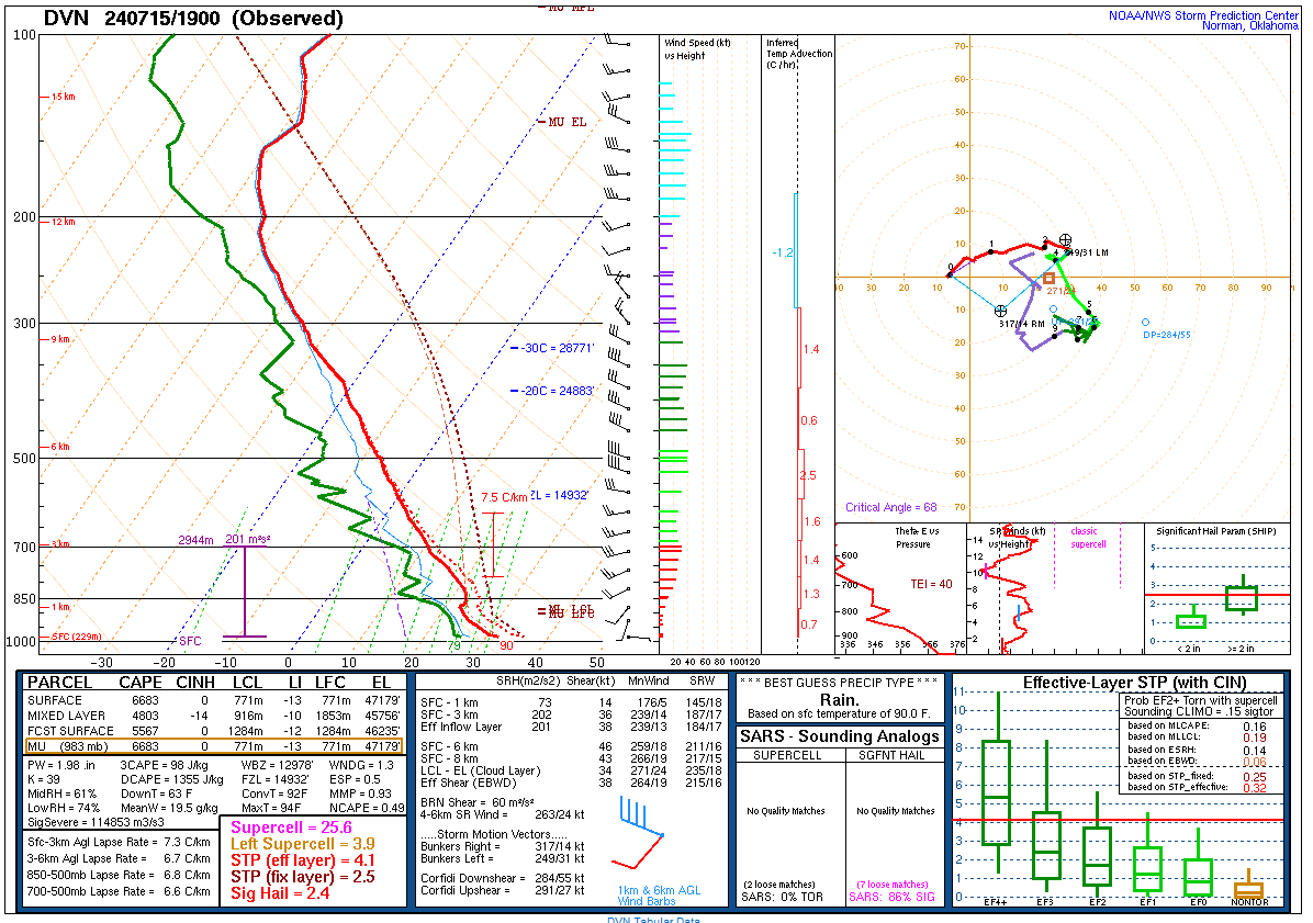
19Z special sounding at DVN, Powder keg ready to blow.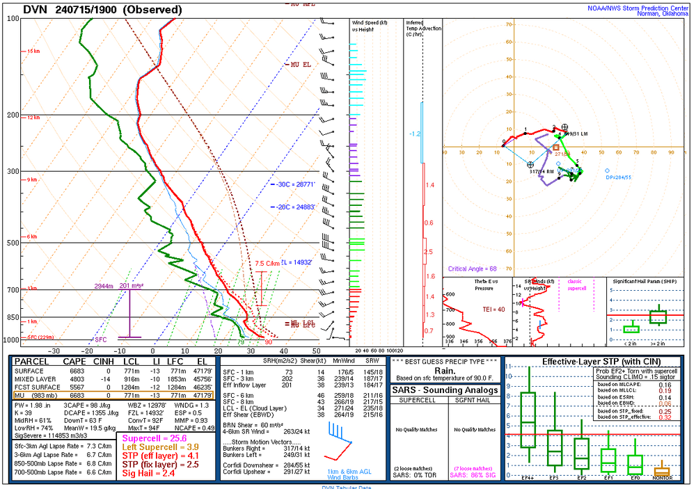
-
2024 Short/Medium Range Severe Weather Discussion
mjwise replied to Chicago Storm's topic in Lakes/Ohio Valley
Upgrade to moderate flash flooding risk this evening for Rockford and Chicago. It will all depend on how progressive this evening's line is and if we see a significant WAA wing and/or training occurring on the back end.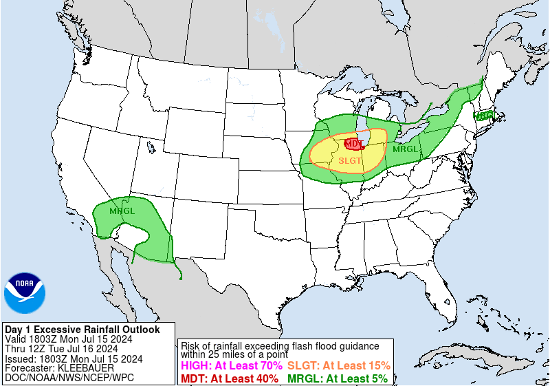
-
2024 Short/Medium Range Severe Weather Discussion
mjwise replied to Chicago Storm's topic in Lakes/Ohio Valley
Enough tree limbs down here to crush about half of my garden. It just has not been a good garden year. -
2024 Short/Medium Range Severe Weather Discussion
mjwise replied to Chicago Storm's topic in Lakes/Ohio Valley
Really good light show in the small leading WAA wing. ETA: Big boy wind with this line. No wind report at KDKB on the 9:15 observation. The ASOS is damaged per the METAR report. -
2024 Short/Medium Range Severe Weather Discussion
mjwise replied to Chicago Storm's topic in Lakes/Ohio Valley
The HRRR is insistent on convection erupting and a linear looking MCS congealing very quickly around 7-8PM in the IA/IL/WI tri-state region and then bowing southeast across S WI, N IL into NW IN in the late evening/early overnight hours. The HRDPS supports that as does the 3km NAM. The globals sort of show that for today but have better support for a similar looking setup tomorrow night. We may pull off the rare "MCS wave" getting three consecutive nights of evening or nocturnal boomers here if it all comes together. ETA: Upgrade to Enhanced on Day 2 for E IA/N IL/N IN.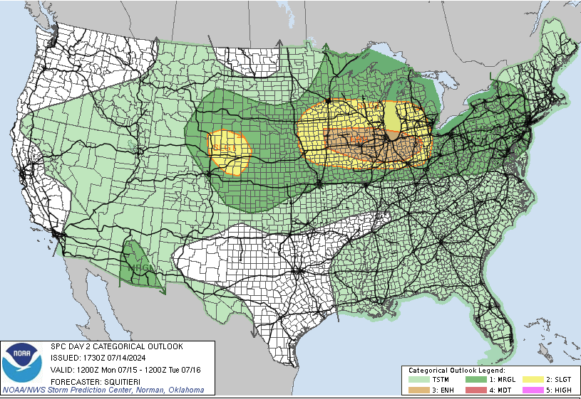
-
Summer 2024 Medium/Long Range Discussion
mjwise replied to Chicago Storm's topic in Lakes/Ohio Valley
The first three weeks of June were lousy here - too warm, too dry and led up to the hot but not unbearable week of 90s but then the switch got flipped and we got a few big boy LLJ firehose events and we greened back up nicely. The ensembles also have not been able to resolve the CONUS pattern very well even in a general sense beyond day 8-9 or so. There's been too much depiction of some vague full latitude ridge that would be suggestive of a plains death ridge type setup that then vanishes in the mid range. It could still happen of course but the ensemble models performance doesn't seem great this year. -
Summer 2024 Medium/Long Range Discussion
mjwise replied to Chicago Storm's topic in Lakes/Ohio Valley
The GEFS and EPS are really struggling lately in the 8-14 day timeframe. -
Just hit 0 here. We were at zero or below for 72 hours. If we don't nudge up to 1 here, we'll end up with about an 84 hour run at 0 or less. ETA: Hit 1 degree after exactly 72 hours of zero to subzero temps.
-
I have heard reports of stranded and abandoned vehicles in rural areas and that blizzard conditions prevailed overnight. ETA: Bottomed out at -14 at the airport, still -10 as of the 2pm observation. This will be my personal coldest daytime temp since January 1994 (-12) assuming we don't gain more than 5 degrees or so. For fun, I took an snow core yesterday from a relatively undisturbed part of my front yard and I measured 2.2" of liquid in ~12" of base.
-
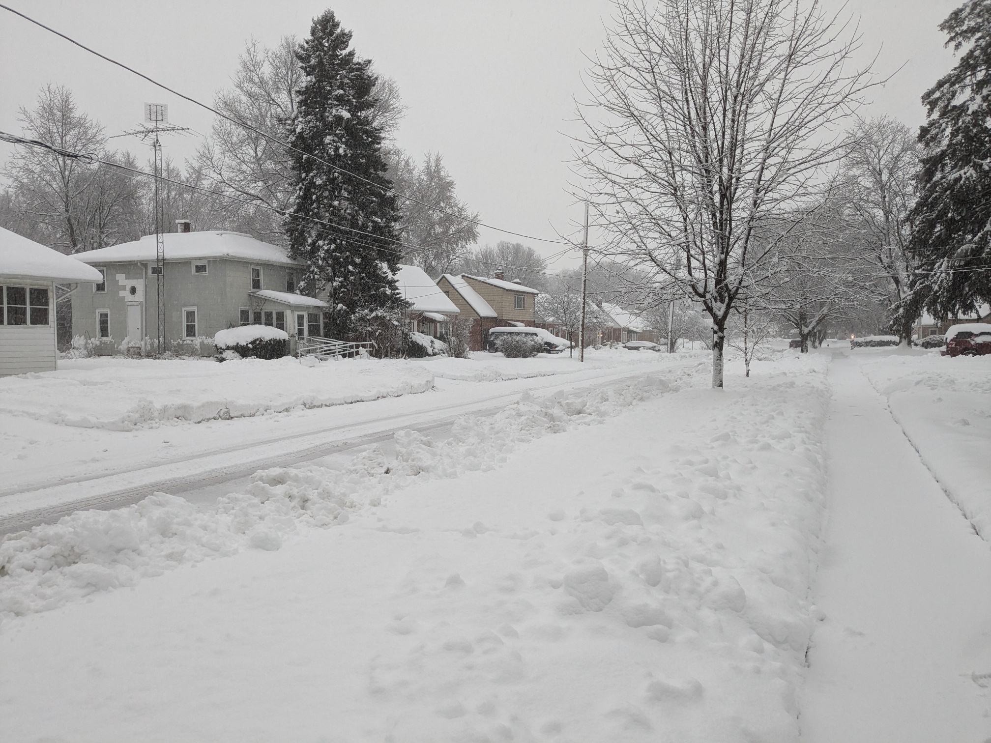
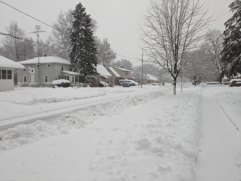
Here's what it looks like at street level here before it gets dark. I don't have measurements, but our total compacted depth (all gained in the past week) is ~12". The bottom 2 inches was thick crust I needed to punch through. It's been all snow except for about 30 minutes of mixed SN/IP at about 8:30am. Sorry I didn't get a morning shot - buildings were plastered with snow from the weenie band but then temps went to 33 and most of it melted off the sides of buildings.
-
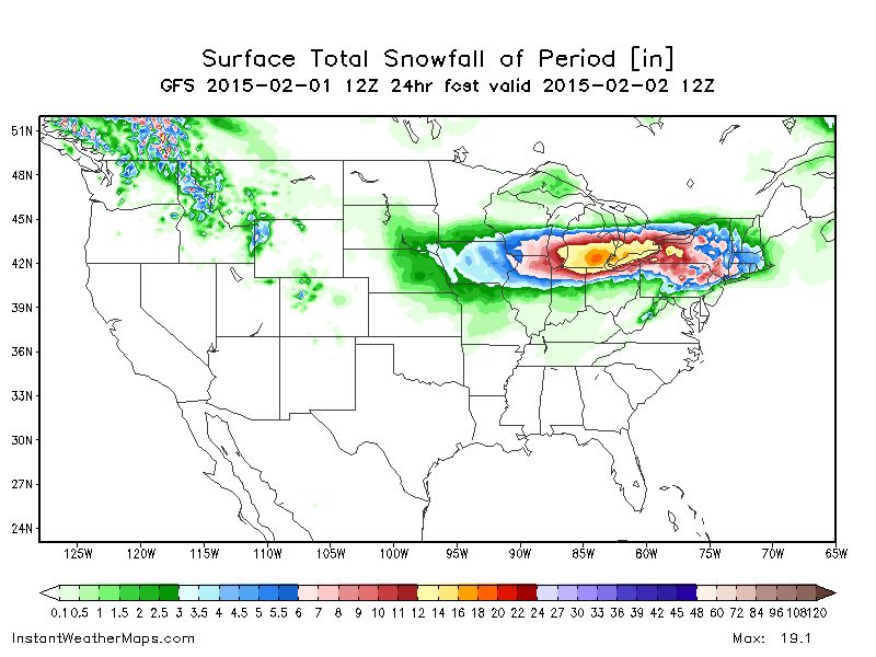
A not insignificant number of SREF members had rain getting all the way up to Madison for at least some of Friday in earlier runs today. QPF hasn't changed much, it was just running a blowtorch earlier.
-
Middle 3rd of the country is pasted with wind advisories or high wind watches. I haven't seen so many issued for some time. Air travel is going to be rough at best the next few days even outside of places that get snow.
-
Only about a 350 mile movement on the slp location versus the 12z run, where it was making for Wisconsin via Dubuque when the run ended...