weathafella
-
Posts
50,111 -
Joined
-
Last visited
Content Type
Profiles
Blogs
Forums
American Weather
Media Demo
Store
Gallery
Everything posted by weathafella
-
July has arrived ... the Meteorologically defined mid summer month
weathafella replied to Typhoon Tip's topic in New England
BOS hit 90 today. If it makes it tomorrow it will be a 3 day heatwave fwiw. -
July has arrived ... the Meteorologically defined mid summer month
weathafella replied to Typhoon Tip's topic in New England
Never. I go out completely zinced up and generally avoid any time before 6pm. I walk tons at night though. -
July has arrived ... the Meteorologically defined mid summer month
weathafella replied to Typhoon Tip's topic in New England
BOS high today was 91. Honestly it was brutal with dews in the 70s. I’m ready for a break. -
July has arrived ... the Meteorologically defined mid summer month
weathafella replied to Typhoon Tip's topic in New England
Phoenix -
July has arrived ... the Meteorologically defined mid summer month
weathafella replied to Typhoon Tip's topic in New England
That Canadian air may be smoky at times. Yay. -
July has arrived ... the Meteorologically defined mid summer month
weathafella replied to Typhoon Tip's topic in New England
Looks like next week is much less humid with AOB temperatures before mr. WAR asserts itself moving into the 2nd week of August and beyond. -
July has arrived ... the Meteorologically defined mid summer month
weathafella replied to Typhoon Tip's topic in New England
Is there a way to compare June through August only? -
July has arrived ... the Meteorologically defined mid summer month
weathafella replied to Typhoon Tip's topic in New England
I know. I happen to be a follower of wx since age 6-70 years ago. Normal max hasn’t changed much in any season. But dews are higher. When I was a kid, dews 60-65 were considered humid, 65-70 very humid, and 70+ oppressive. 70+ was quite rare in NJ in my growing up years. -
July has arrived ... the Meteorologically defined mid summer month
weathafella replied to Typhoon Tip's topic in New England
I’m not sure what they average but I grew up in NJ. It’s generally as humid or more here now. Fact. -
July has arrived ... the Meteorologically defined mid summer month
weathafella replied to Typhoon Tip's topic in New England
I think the point is we’re now the old mid Atlantic dew wise but it’s still obviously more oppressive there. A/C is an absolute necessity in all of sne below 2k. Before anyone sells their home, put it in-it’s now expected. When my wife and were first together 31 years ago, we used ac on some nights. A/C has been on continuously this summer. -
July has arrived ... the Meteorologically defined mid summer month
weathafella replied to Typhoon Tip's topic in New England
Hands down the best summer weekend so far. Gorgeous yesterday and today and nice and warm but not uncomfortable. -
July has arrived ... the Meteorologically defined mid summer month
weathafella replied to Typhoon Tip's topic in New England
White knuckle drive in pounding rain with thankfully good and frequent illumination from lightning around 10pm last night with the last round driving from north Cambridge home. Looks kind of hot next week. -
Great write up Ray. This winter could be an excellent learning opportunity as it evolves with respect to enso.
-
Good thoughts. I may be reacting emotionally to the distribution and it’s definitely a quick take without any of the deeper questions you raise.
-
Fair enough. My interpretation is entirely based on the premise of a robust east based nino-no other analysis and admittedly not considering mitigating factors. 20 years ago I would deep dive this stuff but I no longer have the patience. With that said, I want those ssta anomalies to shuffle or I will be rather pessimistic regarding winter here.
-
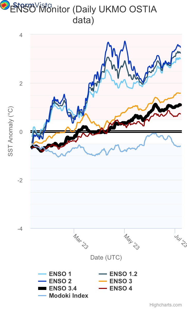
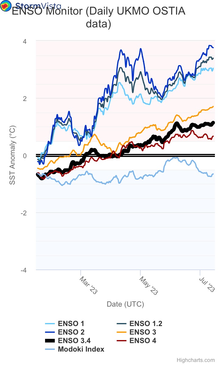
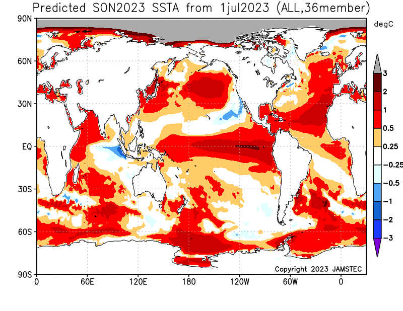
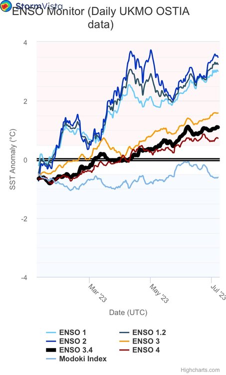
Ray, the SSTA maps are exactly what I said. The post from me that you quoted stated much better look December to February but my assertion is that’s too late although it could allow for a late blooming winter but not enough time to make up snowfall deficit. September through November looks similar to now:
-
It sucks for us September through November with a much better look December through February. It would argue for a late blooming winter with lower than normal snow given lag. December through February would probably suck. And that’s if it’s right. I’m not making any predictions-yet. But if it looks like the current picture in September imho we’re screwed.
-
July 16, 2023 Flooding & Tornado Potential
weathafella replied to WxWatcher007's topic in New England
It will be done by daybreak tomorrow… -
July has arrived ... the Meteorologically defined mid summer month
weathafella replied to Typhoon Tip's topic in New England
I actually live on a slope but a French drain ftw diverting the water down to the bottom of the hill away from the house. -
July has arrived ... the Meteorologically defined mid summer month
weathafella replied to Typhoon Tip's topic in New England
I can’t remember a warmer rain. I walked outside and it felt like shower water coming down. -
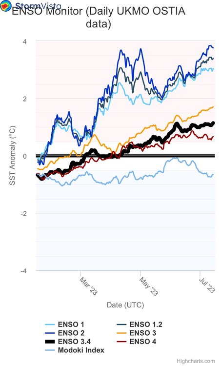
Another week-not much change. 3.4 probably never gets to low strong at most but man that east basis spooks me!
-
Thursday, July 13 - Friday, July 14, 2023 Convection
weathafella replied to weatherwiz's topic in New England
Can this hold up another hour or 2? -
July has arrived ... the Meteorologically defined mid summer month
weathafella replied to Typhoon Tip's topic in New England
Great trip! We’ll be there in early autumn which should be warm but tolerable which will include a week in Rome, 3 days on the Amalfi coast, and a week in Sicily. -
I was a freshman in college in upstate NY for the blizzard of ‘66. Absolutely crushed with close to 3 feet!
-
I’d take 1965-66 in a heartbeat.