luckyweather
-
Posts
595 -
Joined
-
Last visited


-

Spring 2025 Medium/Long Range Discussion
luckyweather replied to Chicago Storm's topic in Lakes/Ohio Valley
mjo moving phases and ssw incoming. potentially more active, cold, and stormier around here (chicago) later into March. (am a weather dummy also, hopefully the professor is proud but prepared for my lashes) -
Fall/Winter '24 Banter and Complaints Go Here
luckyweather replied to IWXwx's topic in Lakes/Ohio Valley
I go to DC annually to visit privately with most of the IL congresspeople, I’ll be in DC in two weeks and am going to hammer them on NOAA/NWS. Like him or hate him Rep Bill Foster has built his brand on being the pro science voice of Congress, going to be particularly interested to hear his take. -
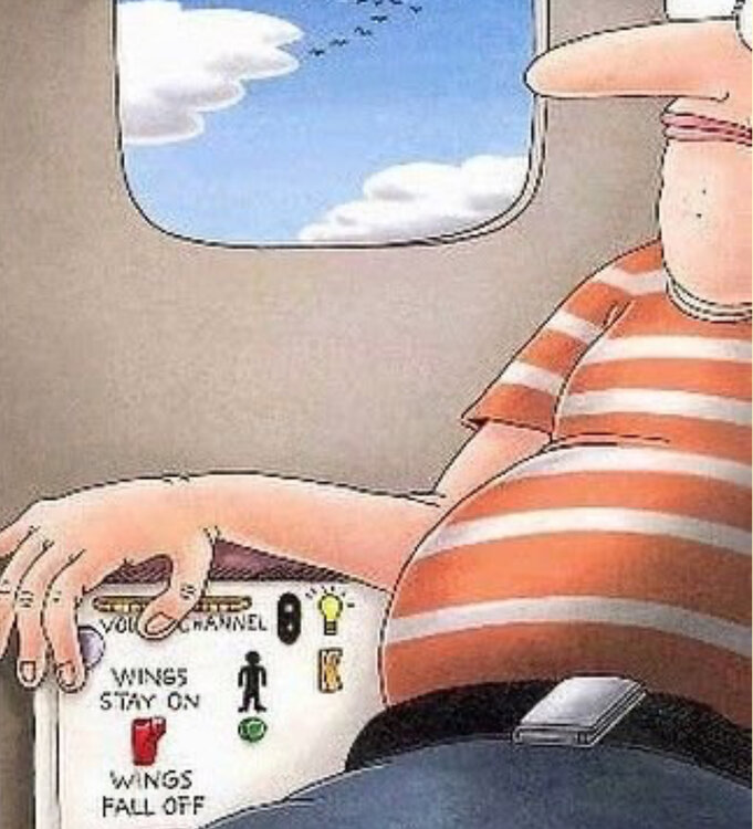
unlikely wx related if the wing is missing. passenger probably bumped the wings fall off toggle switch.
-
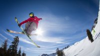
^^^ a rare sight x2, the stateline chair spinning at Wilmot for the first time in a few years, and fresh goods coming down for the lift ride
-
- 711 replies
-
- 11
-

-
Fall/Winter '24 Banter and Complaints Go Here
luckyweather replied to IWXwx's topic in Lakes/Ohio Valley
Got some snow laid down with a few hours of wet bulb temps of 20 or so, although the wind made it pretty inefficient. All the N. IL and So WI ski areas have been blowing for the past few days. Alpine Valley and Tyrol Basin in WI open tomorrow as well as Sundown in Iowa. Chestnut in IL looks to open next weekend along with Cascade, Devils Head, Granite Peak, and Wilmot in WI. -
Fall/Winter '24 Banter and Complaints Go Here
luckyweather replied to IWXwx's topic in Lakes/Ohio Valley
maybe we get to do a jebwalk? -
Seven tenths today northeast of Rockford
-
Spring/Summer '24 Banter and Complaint Thread
luckyweather replied to IWXwx's topic in Lakes/Ohio Valley
Really sorry to see this and sending warmth to you Stebo and your family, donated, hope it helps. I imagine you’ve got this covered but just in case not, would retain a lawyer who specializes in bike law, there are several in Michigan. All too often I see the perps of cyclist hit and runs somehow get off with no or little punishment. It’s like somehow what otherwise would be straight up murder is okay because it was car vs bike. The specialty bike lawyers are prepared for that and know how to fight for accountability while obviously trying to recoup their fees and ensure the family is able to recover costs and some form of settlement. I got dinged on a Divvy in the south loop on Labor Day weekend by some clown, I wasn’t hurt and was able to keep riding but the guy just threw up his arms at me and sped off. Sorry bro, I was riding on the marked green bike lane and you decided to come out of a blind alley at 30mph, I was definitely the asshole. -
Spring/Summer '24 Banter and Complaint Thread
luckyweather replied to IWXwx's topic in Lakes/Ohio Valley
Looks like common hop. Common hop is a vine that’s native here in N. IL. -
2024 Short/Medium Range Severe Weather Discussion
luckyweather replied to Chicago Storm's topic in Lakes/Ohio Valley
https://x.com/PettusWX/status/1804681264936415268 Janesville tornado on traffic cam -
2024 Short/Medium Range Severe Weather Discussion
luckyweather replied to Chicago Storm's topic in Lakes/Ohio Valley
watch incoming for west LOT Mesoscale Discussion 1372 NWS Storm Prediction Center Norman OK 1256 PM CDT Sat Jun 22 2024 Areas affected...Portions of northeastern IA...northern IL...and southern WI Concerning...Severe potential...Watch likely Valid 221756Z - 222000Z Probability of Watch Issuance...95 percent SUMMARY...Severe storms capable of producing damaging winds, a couple tornadoes, and isolated large hail are expected this afternoon into the evening. A watch is likely in the next hour or two. DISCUSSION...Latest visible satellite imagery indicates filtered diurnal heating/destabilization of a very moist boundary layer (middle 70s dewpoints) along/south of an east/west-oriented stationary boundary extending across portions of northern IA into southern WI. Over the next couple hours, a weak frontal wave currently near far northwest IA will track eastward along the boundary, promoting scattered thunderstorm development -- aided by the aforementioned destabilization and modest midlevel height falls ahead of a midlevel trough. Around 50 kt of midlevel westerly flow atop a 30-40-kt southwesterly low-level jet (per regional VWP) will promote organized surface-based storms (including a few supercells) near the boundary. Easterly storm motions and deep-layer shear parallel to the boundary may favor congealing cold pools and localized upscale growth, though the favorable shear profile (large clockwise-curved low-level hodographs) should encourage a few sustained semi-discrete supercells. Damaging winds up to 70 mph, a couple tornadoes, and isolated large hail are all possible with this activity. Current thinking is that severe storms will develop/mature in the 19-20Z time frame and persist into the evening hours. A watch is likely for parts of the area in the next hour or two. ..Weinman/Hart.. 06/22/2024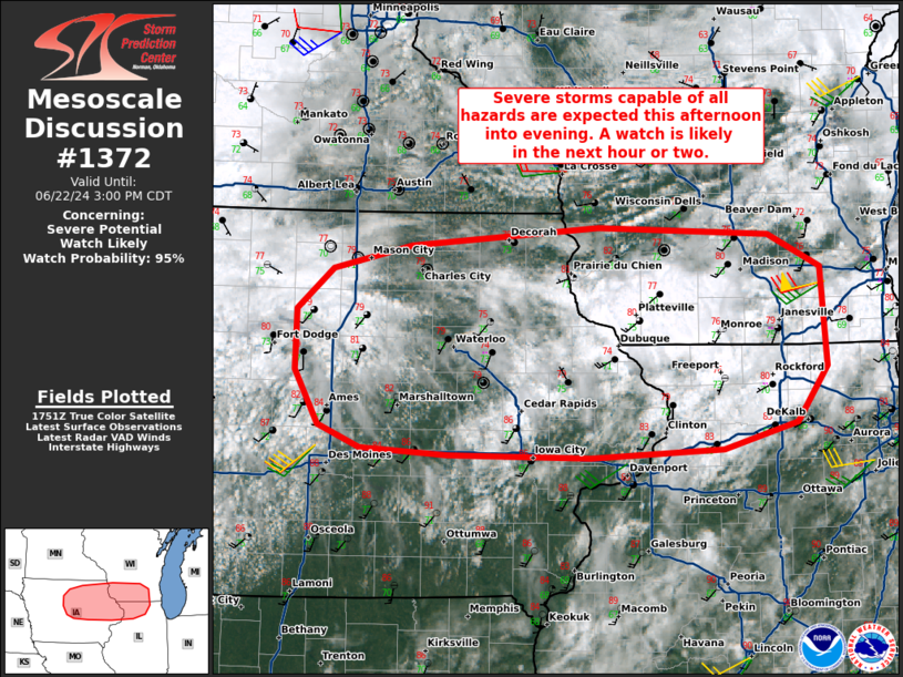
-
where are you again? (can’t see on mobile). was thinking glen ellyn or somewhere in that vicinity? if so, wild the regional feast/famine, seems like we get .25” rain at least every other day since March here in NC IL.
-
Less than 3 weeks til we start losing daylight!
-
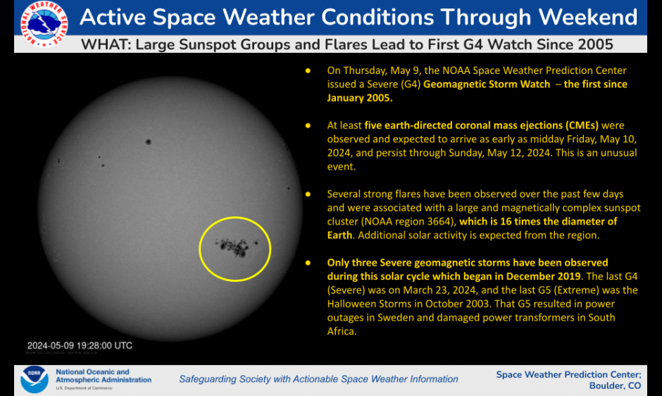
https://www.swpc.noaa.gov/news/swpc-issues-its-first-g4-watch-2005 If we can clear out early Friday night might see a couple times in a lifetime level northern lights here. Saturday night looks better for clear skies but not sure if there’ll be any aurora then. The 5-10% chance of a Carrington event redux over the next 24-36 hours or so is pretty wild also.