

WEATHER53
-
Posts
6,848 -
Joined
-
Last visited
Content Type
Profiles
Blogs
Forums
American Weather
Media Demo
Store
Gallery
Posts posted by WEATHER53
-
-
High is hanging back west which is not allowing much north move but will serve us later. Is the warm tongue between 700-825 because it not going to be between 500-700.
-
4 minutes ago, snowdude said:
Interesting observation from Mount Holly. Maybe models underdoing the initial banding lifting north, especially eastern edge? Or maybe it means nothing.
...930 AM Update: No changes made yet to the forecast for this
period, as we are waiting to see more of the 12Z guidance.
However, it is interesting to note that the current
precipitation shield extends further east (across the Carolinas)
than what the models had depicted. I am not sure this will
result in any significant changes for our area as models already
had the precip extending across our region by late tomorrow. We
will have a complete update on this system with the 4 PM update.
Yes there is a decided eastern move but looks like lifting north is starting. 1040 still west of us and that’s a good sign for cold not substantially being east of us come crunch time and then see what effect it has on changeover
-
17 minutes ago, C.A.P.E. said:
Not sure how much further west you want it, but overall recent guidance seems to at least have it positioned more towards our NE instead of it sliding more to the E/SE. Thats a good trend IMO, and looks to keep the cold in longer.
Would like it along the ny/pa border or bit nw of that and not vt/Maine.
-
Need the high further west. That will be the key
-
37 minutes ago, psuhoffman said:
unfortunately they left your keyboard
Will be very cold here 3/1-3/3
-
30.10 High pressures aren’t suppressive
-
Unreal on the timing for couple big timers throwing in towel last week and now upcoming longest cold streak of winter Plus stormy!
-
BWI been at 32 for 11 consecutive hours. Don’t know if any such records are kept but that may be one.
-
Icy snow moderate but no sleet 0.7”; 32.5F
-
Hard to sleet when all levels are right. Fun changevlinevto watch and dc still snow for now
-
Heavy snow, 1”ph, 0.5accum., 32.6 F
-
8 minutes ago, BristowWx said:
That 850 line booked NE like the train to Philly. Showed me what could have been for about an hour.
Went up 0.5 in an hour over dc. Still -1.5
-
Got a solid dusting and cars covered. Stuck on them right from start which is often a sign of good things aloft. Cold air will lose but never gives up easy this winter.
-
7 minutes ago, MD Snow said:
most recent 850mb temps
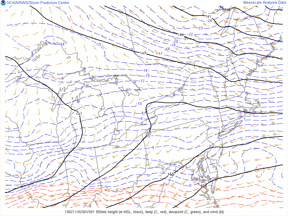
That’s a big drop in 850svover last hour !
-
30 minutes ago, lpaschall said:
Looks like that slug of moisture on radar is going to pass south of me.
That might have been sleet. Any repots of it?
-
Light snow. Good flake size already .Temp drop 0.8 since onset so some evap, 33.8F. Now the battle of air masses where rain wins out but how long to do so.
-
Beer talk to banter please
-
 2
2
-
 3
3
-
-
Gotta love the “I’m out” pouts. Seen it six times this winter right before we get snow
-
34 minutes ago, North Balti Zen said:
You are talking in code again. The eagle flies at midnight.
Sorry. Next time I will tell you what the models say.
-
1
-
-
What’s 30.70 going to do? Almost uncharted territory
-
 1
1
-
-
Synoptic history is the way to go but it requires years of monitoring events to establish a pattern of outcome. Models use very little analog data and are mostly math calculations of A +B=C or B+C=D, examples; but not prediction. Almost the only think I look at now is precedent and current 500mb patterns and as something gets closer then 850s and boundary. Keith does this also and is better with seasonal patterns then anyone I’ve ever met or seen and hes nailing it again this winter.
Start keeping records of set ups and outcomes. It takes a while but if you do it to even 60% accuracy then you won’t need to wring your hands over every 6 hours.
-
2
-
-
Remember models are not predictors of outcome nor even “most likely scenario”.They cover all the bases for a time frame and somewhere in representation over a 1-7 day period one of those projections will confirm and thus more funding to do it all over again.
if you want to be a model reader then fine but if you want to learn how to predict what will most likely happen then a different method must be employed.
-
2
-
-
Even has a look of low just goes northwest and never does more than throw a warm front up this way(again). Get high to be on the nipple, or udder if you wish, of Hudson/James Bay and it would be special long duration.
-
2 hours ago, losetoa6 said:
Ukie also coming in flatter and weaker overall . It takes the primary due east from hr 96 to 120 with hardly any north trajectory and it hints at coastal redevelopment. It should be a decent hit me thinks. The high is weaker then other guidance but with that track and weaker primary should be good bit of frozen

See how the isobar line connected with the high runs thru western md. Before decoupling. That’s a snow marker for DC
2/19-20 Winter Storm Observations
in Mid Atlantic
Posted
1pm obs
Very light snow, 5” accum, 30F