

WEATHER53
-
Posts
7,712 -
Joined
-
Last visited
Content Type
Profiles
Blogs
Forums
American Weather
Media Demo
Store
Gallery
Posts posted by WEATHER53
-
-
1 minute ago, Kmlwx said:
It just updated (must be hourly at night maybe)...but it's showing a decent rise at the 11:45pm update. 210cfs for discharge and 2.79ft
I saw the 10:45 and it was 1.4 in height
Where is Sligo Creeks one?
-
Drowning continuing at 1.3”
Anybody got maps for current rainfall?
-
4 minutes ago, Kmlwx said:
The coordinates for it put it near that old bridge that's closed off. It seems like it's just a hair south of actual Randolph Rd. This time of year probably not visible from the road - but perhaps in winter?
Yes I think it’s right at the old bridge
-
8 minutes ago, Kmlwx said:
What a deluge out there - NWS posted a flash flood warning now. Well warranted if this keeps up. I'm keeping an eye on the USGS gauge on NW Branch near Kemp Mill Rd.
EDIT: The gauge hasn't updated since 0245z (about an hour ago at this point). It does generally lag a bit - but normally only by 30-45 mins. Suspect that the next update will show rising water at this point. Link below for both of you as it should be fairly representative for any creeks in our area.
https://waterdata.usgs.gov/md/nwis/uv/?site_no=01650500&PARAmeter_cd=00065,00060,62615,62620
https://water.weather.gov/ahps2/hydrograph_to_xml.php?gage=clam2&output=tabular
Exactly where the Kemp Mill NW Branch one ? Up by Randolph or down the trail off KM?
-
5 minutes ago, AU74 said:
Yep, here between Colesville and Cloverly as well. More to come I think based on radar.
Us three close and Ke### and I frequently have same results in these isolated set ups.
-
 1
1
-
-
Lightning close 2 miles or so and just hit 1”
-
I am the red and dark red blobs. Bit spooky, would not want this for hour after hour
-
Another quick hitter deluge. I gotta clear some drain lines now
0.6 in 13 minutes and .75 in 20
-
Another daily short term deluge. 0.6 in 13 minutes and ..75 for entire 20 minutes
-
1 hour ago, Windspeed said:
Just to jump off topic here, briefly, Josh was never in a reporting capacity for TWC. They reached out to him while he was on his regular chase schedule for several hurricanes. The WN gig was their decision to contract him for work and he took it. Fred was not a normal chase. Additionally, Josh now lives on the Gulf coast during hurricane season for this very reason. He has a particularly great skill set that can be advantageous for any particular network coverage. That being said, if there is an intense hurricane landfall, he's going to be in chase mode, not coverage mode.
At any rate, no need to berate the man for getting paid.
Speaking of...Josh still lurks so Hey Josh what’s with the grey hair and greying beard??
I remember when you were Too Young to grow facial hair!!!-
1
-
 1
1
-
-
16 minutes ago, NavarreDon said:
I’m in between Pensacola & Fort Walton Beach. Grayton & Seagrove are on 30A in Walton county. They are about halfway between me and the projected landfall area.
.I don’t know how things lay down there so can you break it down Into miles and east or west?
thanks
-
2 hours ago, NavarreDon said:
Out on Navarre Beach, you can see the storm off in the distance, surf is up even with the offshore flow.


.I’ve got friends in Grayton Beach and in laws at Seagrove and Grayton had dramatic picture of leading edge.
Where are those two spots in relation to you and projected landfall?
Thanks
-
The one that made the huge wave that swallowed that island right before Christmas about 10 years ago. Isn’t that the biggest in a while?
-
2 hours ago, WxWatcher007 said:
This is an open discussion IMO. Red tag or not your analytical posts should have a basis in fact/observation. I don’t think anyone should be above critique. How else would we learn anything?
Anyway, recon is finally finding a LLC, albeit weak.
The idea was to have a hobbyist site where information could be shared, discussions conducted. Many of us had been at TWC and Wright and Accuweather but there was a desire for a site of our own so to speak. I never got fully involved so there are 3/4 on here who ran and run the show and can add more.
-
1 hour ago, Prospero said:
My little arrow was slightly too far right based on the TidBit image. Convection did not wrap around it fully, shear got it.
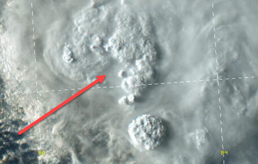
Is that towering circle to SSE a part of it, helping it or hurting it or no effect ?
-
This site was not created by nor for Red tags. They are as contributory as anyone else and are equally qualified for rebuke.
-
4
-
1
-
-
I believe earthquakes and their effect deep down in oceans are instrumental in the increase of ocean temps.
-
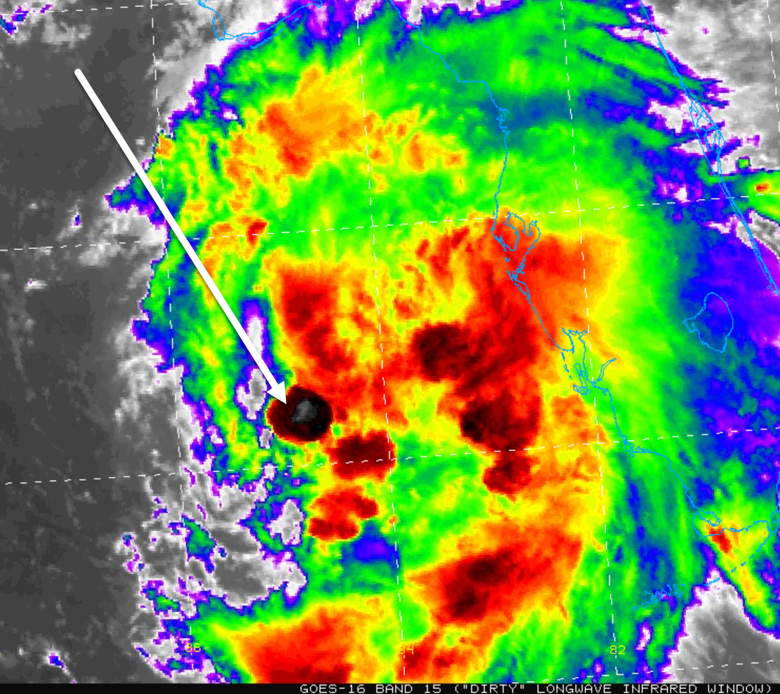
42 minutes ago, Prospero said:
First time I remember seeing a convection burst directly over the LLC of Fred.

Is the shear lessening?
-
Think DCA got like 2.2” between midnight and 1am.
I was on northern fringe and had three separate deluges totaling 1.3” over two hours
-
4 hours ago, ldub23 said:
Yea, very el nino like. Phase 2 MJO isnt doing much. 2 very very weak lows.
Going to have to see how this works out. 75% of you killed off Fred and now are Grace. Pessimism is not forecasting.
Experience shows that storms that get battered by Cuba and the like do reintensify when they move back into Gulf with anything remnant left of them and begin a nw-ne motion.
This appears to be happening with Fred and if that shear drops away, which is possible but not likely, then watch out
-
2
-
-
Rain just finished a Scary loud 5 minute torrent
-
Blowing up on radar. College Park hammered, not quite here yet
-
1
-
-
23 minutes ago, high risk said:
It's probably just my fading memory, but I can't recall such an extremely active week like this with so little shear.
I would say 2010
-
4 minutes ago, The Dude said:
Drove around a bit. A number of trees down, a ton of branches down. Definitely a top 5 storm over the past 18 years that I've lived here.
I think winds may have been 60?
August 2021 Discussion/Obs
in Mid Atlantic
Posted
Being lashed again. It rains so hard it sounds like wind but winds are calm