MNstorms
-
Posts
439 -
Joined
-
Last visited
Content Type
Profiles
Blogs
Forums
American Weather
Media Demo
Store
Gallery
Everything posted by MNstorms
-
A bit out but the models have snow next Thursday night into Friday here in southern Minnesota. A early winter?
-
Pacific becoming active. GFS has a Fujiwhara effect happening.
-
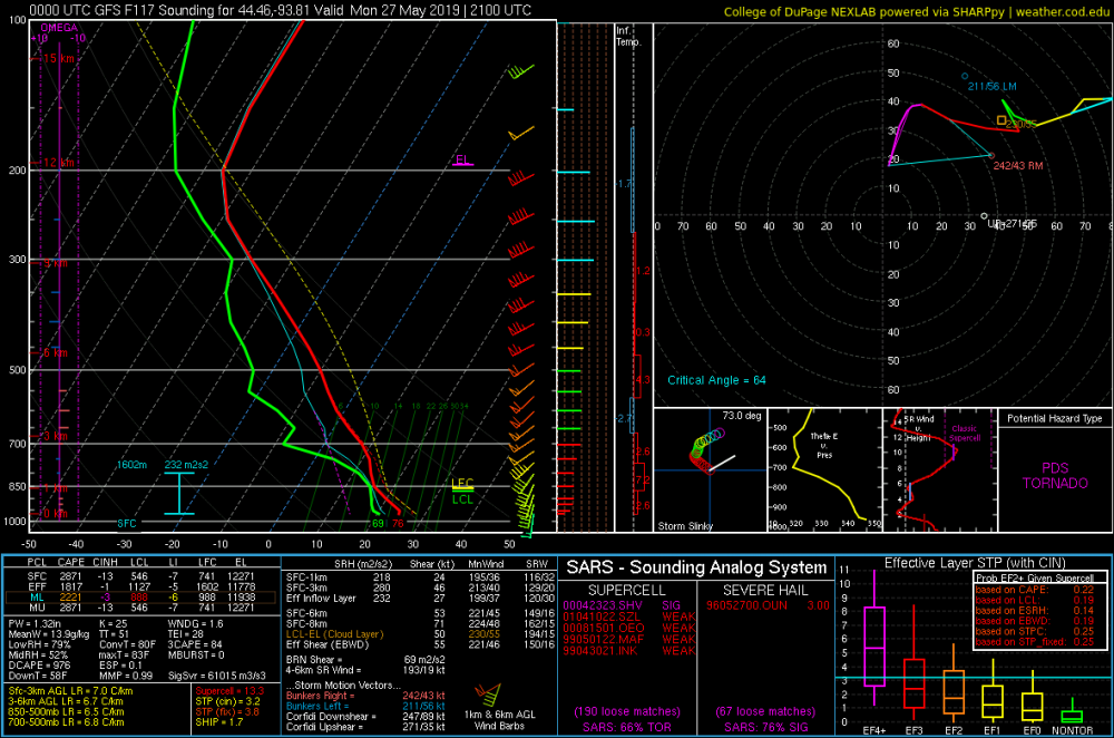
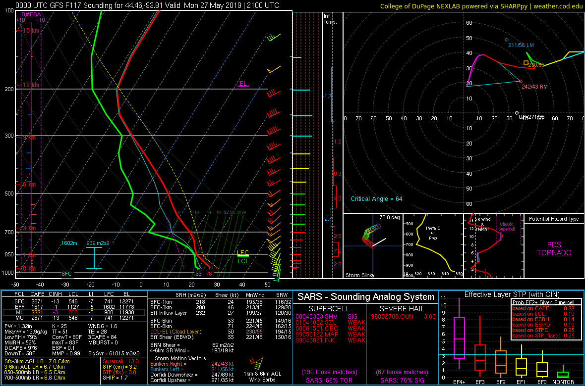
I switched out the sounding in the opening post for you to look at.
-
Can you explain? Is it the the red bars on the left? There's soundings within a few miles without them but everything else about the same. Some things on soundings I'm still learning about.
-
A few active days here late in the season. Mostly wind event but tornadoes are possible. Tomorrow looks interesting imo. Warm sector setup with strong shear. Tomorrow: Southern MN:
-
A couple of active days late in the season.
-

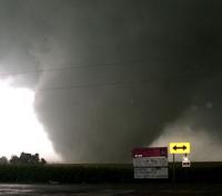
7-19 Severe outbreak MN into upper MI
MNstorms replied to janetjanet998's topic in Lakes/Ohio Valley
Well they were right. EAU CLAIRE,WI (EAU) ASOS reports gust of 91 knots (105.1 mph) from NW @ 2356Z -- KEAU 192356Z 32025G47 8SM -TSRA FEW028 BKN035 BKN044 24/19 A2966 RMK AO2 PK WND 32047/2341 LTG DSNT ALQDS RAB55 TSB55 SLP038 TS OHD MOV E P0000 60000 T02390194 10333 20239 53006 -
7-19 Severe outbreak MN into upper MI
MNstorms replied to janetjanet998's topic in Lakes/Ohio Valley
-
7-19 Severe outbreak MN into upper MI
MNstorms replied to janetjanet998's topic in Lakes/Ohio Valley
-
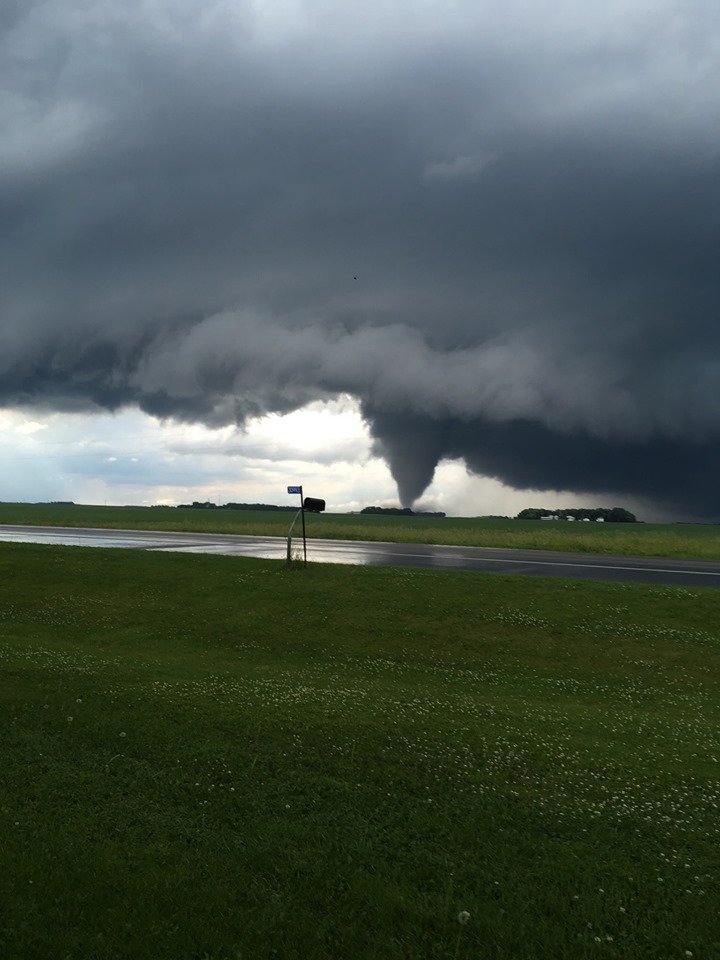
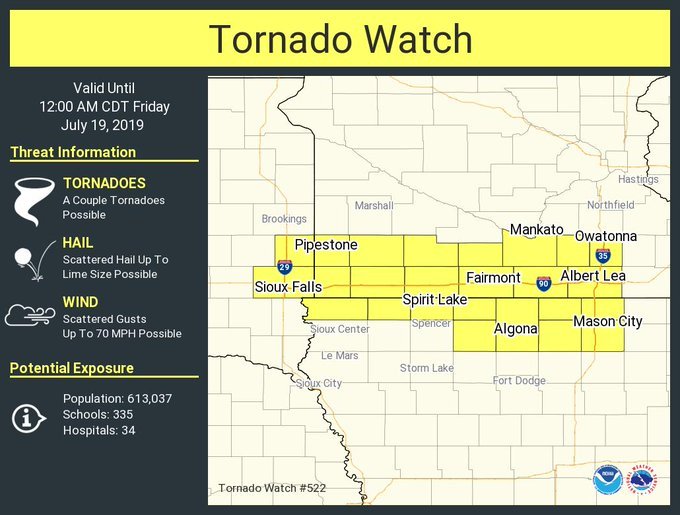
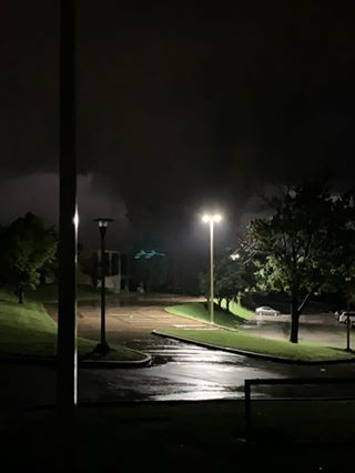
Tomorrow looks to be a tornado outbreak in Minnesota and Wisconsin.
-
Northern MN had tornadoes yesterday. Perhaps Southern MN today. Tomorrow looks interesting.
-
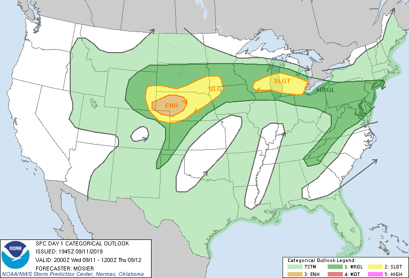
Some scattered severe storms yesterday and today across the upper midwest. Tomorrow could be huge in Minnesota if morning convection doesn't interfere and the cap breaks. So far the SPC only has a slight risk. The models are going crazy.
-
Tuesday looks concerning over Minnesota. NAM ramping things up.
-
It's been a little bit active this week so far. Slight risk from now through Monday. Yesterday had a couple nice looking tornadoes in Wyoming. Almost got my first tornado warning today, off by a few miles.
-
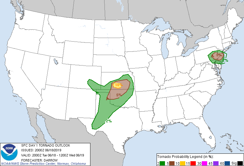
10% in ND with a larger 5%. Tomorrow has a slight risk now too.
.gif.440e7cde85915b97aa7e39d091be55bb.gif)
-
Current storms: Models want a tornado outbreak this afternoon. SPC isn't saying anything. Atmosphere will be used up I assume.

-
Decided to extend that title date since rounds of storms continue. Nice bow echo coming at me tomorrow at noon perhaps.
-
HRRR is impressive for tomorrow.
-
Only tornadoes today seemed to be in a 0% chance spot in west Minnesota. Don't know how the SPC missed this.

-
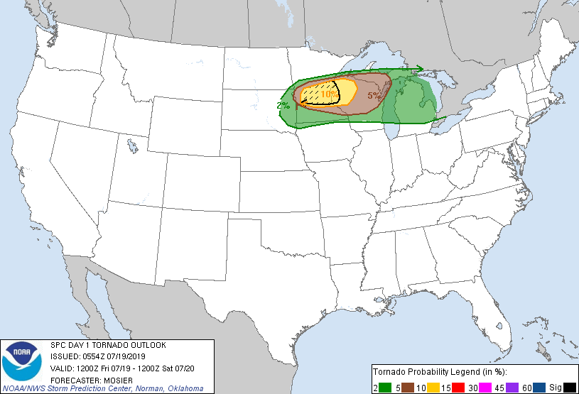
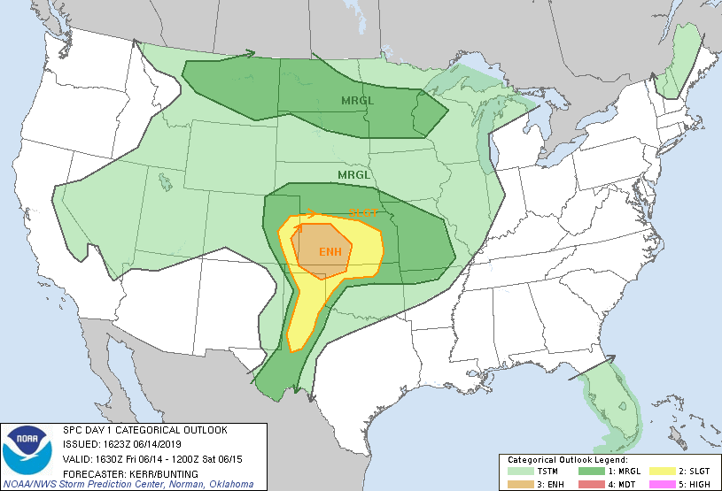
From a 2% at 1am to 10%. Been awhile since I've seen that. Derecho Thursday night and Friday?

-
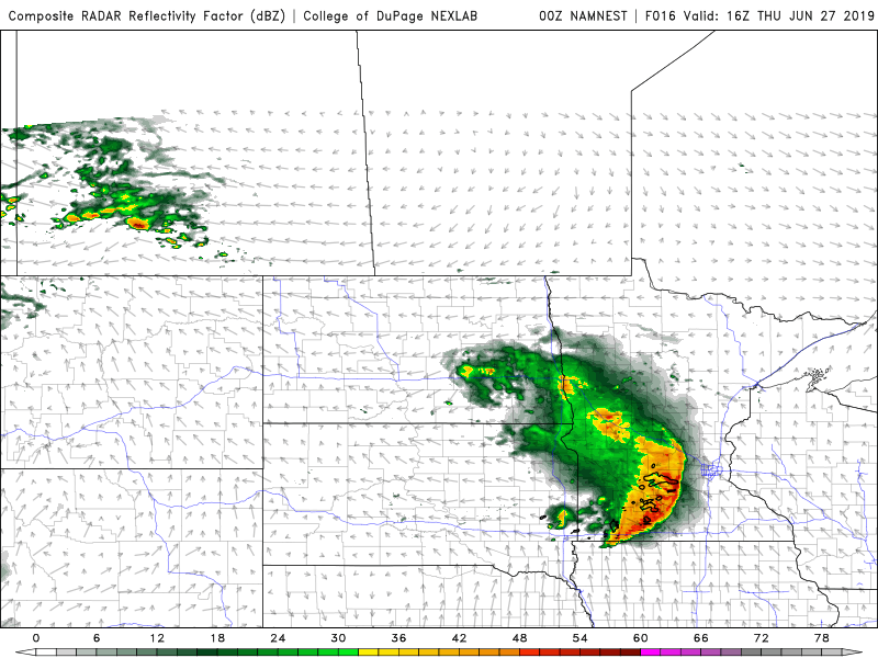
Some active days starting yesterday. Today looks like a decent threat in Kansas.
-
Central/Western Medium-Long Range Discussion
MNstorms replied to andyhb's topic in Central/Western States
Monday is a day to keep a look at imo. 6 days out and the models are in decent agreement it seems.
-
2019 Short/Medium Range Severe Weather Thread
MNstorms replied to snowlover2's topic in Lakes/Ohio Valley
Surprised no one posted it. Good chance at high end severe storms Monday and Tuesday..gif.631a16dc967e934ad6b14f8226e833a3.gif)
-
2019 Short/Medium Range Severe Weather Thread
MNstorms replied to snowlover2's topic in Lakes/Ohio Valley
-
2019 Short/Medium Range Severe Weather Thread
MNstorms replied to snowlover2's topic in Lakes/Ohio Valley
I know it's 5 days out but this is still not great to see for my home.