jrips27
-
Posts
3,462 -
Joined
-
Last visited
Content Type
Profiles
Blogs
Forums
American Weather
Media Demo
Store
Gallery
Everything posted by jrips27
-
-
-
-
Warning out now https://twitter.com/NWSLakeCharles/status/1253148917933281280?s=20
-
From that earlier straight-line wind segment
-
That’a damaging something... probably a pretty widespread 70-80mph swath
-
-
-
HRRR trending north with the front
-
They kept the moderate haha. Good troll.
-
Looks like he deleted this already. Guess we will find out shortly!
-
-
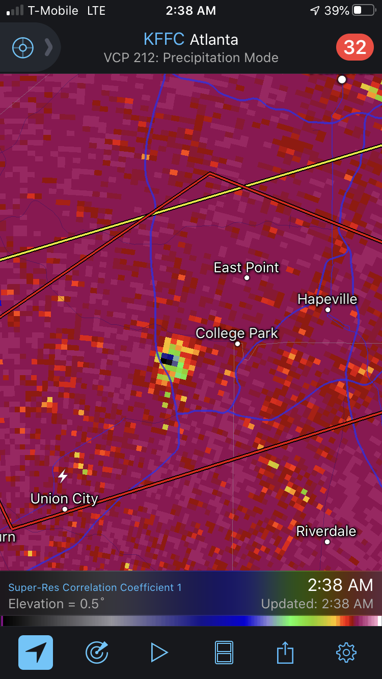
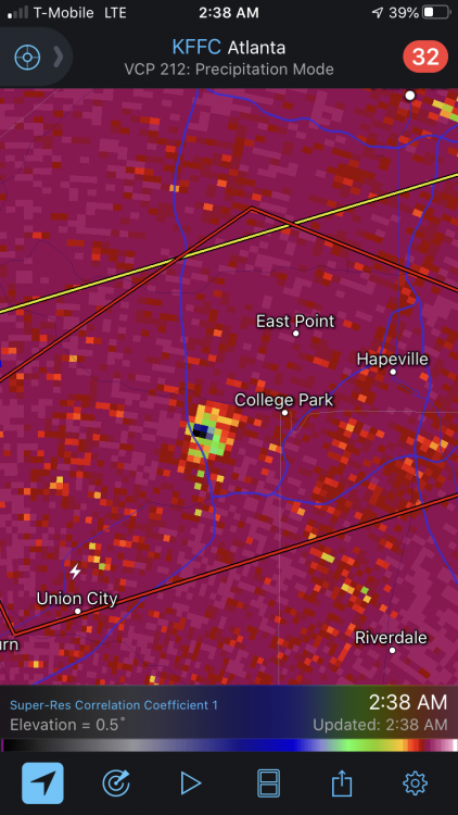
Holy crap in downtown Atlanta
-
Man. Not good at 2am

-
Yep. Classic look on that cell NE of Tuscaloosa. Heading towards Birmingham metro
-
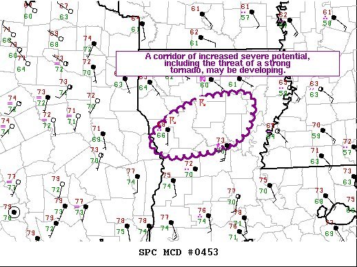
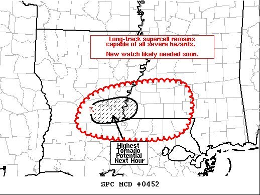
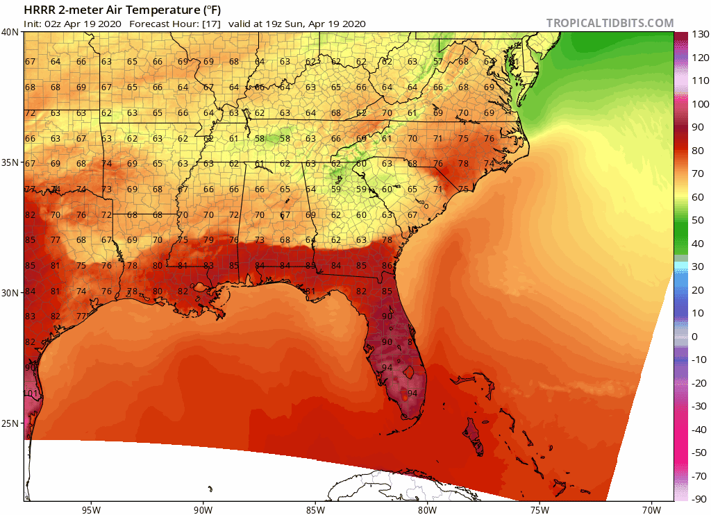
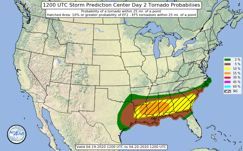
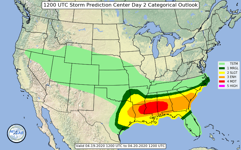
Area Forecast Discussion National Weather Service Peachtree City GA 332 PM EDT Sun Apr 12 2020 ...INCREASED CONCERN OF SIGNIFICANT SEVERE WEATHER OUTBREAK LATE TODAY INTO EARLY MONDAY MORNING... .SHORT TERM /Rest of today through Monday Night/... Things should ramp up quickly here for a significant outbreak of severe storms (possibly the strongest event in at least the last 2 to 3 years) having the big three main threats of strong long- track tornadoes, damaging winds, and large hail this afternoon into the overnight. Much of the western CWA remains in a Moderate Risk with the rest of the area in an Enhanced, though the storm threats could occur area-wide. All the recent convective development across the western and northern CWA has been tapping into mostly elevated instability, though concern is increasing with the evolution of a warm front/lingering wedge front across portions of north Georgia (currently extending near the Atlanta Metro to just south of Athens) as this may end up focusing some stronger rotating convection tapping into more surface based energy along with localized enhanced low level helicity and frontogenetic forcing on top of the ample upper forcing/jet dynamics. The HRRR continues to ramp up the Sig Tor Param along and south of this feature that could slowly lift northward this afternoon into evening and bulk shear vectors have strong veering, so will need to watch for discrete supercell and tornado potential even ahead of the main overnight expected storms. Hi-res CAM consensus continues to have expected intense convective zones/broken lines with embedded supercells pushing into the CWA after about 04z (midnight) tonight pushing eastward through the early morning hours. The HRRR indicates impressive swaths of updraft helicity along these storms interacting with over 400 m2/s2 of 0-1km SRH, so there is concern of some strong long-track tornadoes, even more dangerous given the nocturnal timing. Regardless there will be a widespread damaging wind threat with a robust 65 kt LLJ and 80-100 kts of bulk deep layer shear as the upper wave swings negative.
-
just went TOR warned.
-
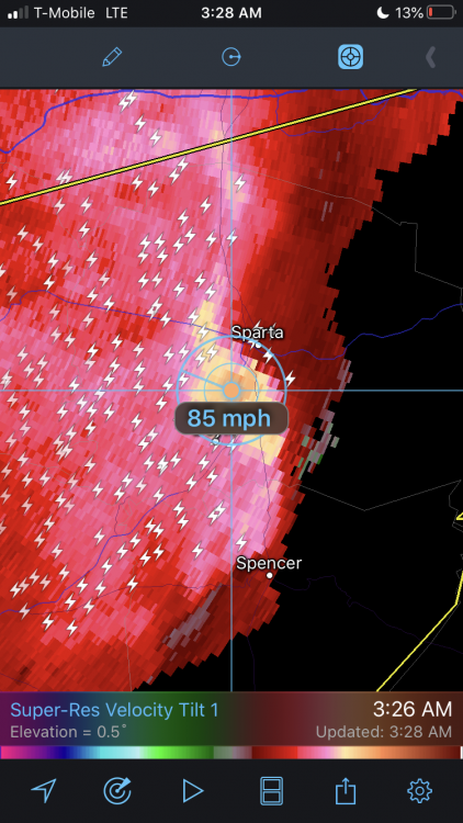
Sparta, TN is about to get rocked by straight line winds 70mph +
-
-
Seems pretty accurate to me. Happy I was in a bullseye in Dahlonega.
-
-
Just measured 3.25” and counting in Dahlonega. Flakes have gone smaller in the past few minutes but setting up for that last band and bigger dimes and quarters are returning!
-
Ripping in Dahlonega where I’m at. It’s awesome!!
-
Think I’m gonna head your way and up into Dahlonega in the morning. Don’t want to risk being too close to the line down here and potentially mixing back and forth all day. 28 degrees where I’m at right now 6 miles ENE of Alpharetta. Feels like the night before a storm. Always love daytime snow and looking up and seeing infinite flakes
-

12/10-11/19 Potential Valley Wide Snow Event.
jrips27 replied to John1122's topic in Tennessee Valley
Thanks for the hospitality guys. Congrats to everyone who saw snow! Cleveland, TN was beautiful. Only about an inch accumulation on cars and grass but it sure was pretty falling. Y’all take care and enjoy winter. Hopefully I’ll be back up for a bigger storm- 486 replies
-
- 5
-

-
- snow
- rain to snow
- (and 2 more)