featherwx
-
Posts
250 -
Joined
-
Last visited
Content Type
Profiles
Blogs
Forums
American Weather
Media Demo
Store
Gallery
Everything posted by featherwx
-
I know I’m being greedy at this point but I just can’t help it. Probably could’ve gotten away with driving to and from work today!
-
Not even a flurry now—I knew there’d be some tight gradients across Cook and possibly within the city, but damn. Birds have even started chirping outside of my office because they think the coast is clear now
-
Okay this is getting ridiculous, still nothing more than a flurry in about 3 hours...
-
Still hardly a flurry here—looks like I’m stuck squarely between the two established bands lol
-
Yeah it’s been coming down very lightly here in the IL Medical District (just south of 290) for the last hour or so. Hoping things pick back up before too long.
-
Point and click with a modest 9-19” now
-
Woohoo! I was just about to ask my roomies what it looked like at our apartment (Wicker Park). WWA would seem like a good idea at this point even if solely based on impact—I just drove to UIC from the Loop and it was a little dicey.
-
Is it just me, having grown up in North Carolina where the potential for an inch of snow is breaking news a week in advance, or are the local news outlets in Chicago not giving this storm nearly enough attention?
-

Jan 25-26th Potential Something Part 3
featherwx replied to Chicago Storm's topic in Lakes/Ohio Valley
It was absolutely ripping as it passed over me in the UIC area about an hour ago, with well-treated main streets getting covered almost instantly. I just got home (about 5 miles NW of the Loop) and it looks like we’ve picked up almost 6” so far—definitely frustrating to have the heavier synoptic stuff stay just north earlier and now the lake effect go just south, but it is what it is! -
Jan 25-26th Potential Something Part 3
featherwx replied to Chicago Storm's topic in Lakes/Ohio Valley
Really hoping this band can push just a little more south and at least get MBY in the West Town area in on the action, if not even more south to UIC where I’m at work. Gonna be tragic if we miss out on most of today’s action by just a few miles.... -
Already almost an inch on the ground and still coming down pretty good here in Nauvoo, IL (right across the Mississippi from the southeast corner of Iowa) even though the NWS point and click now says only an inch total for the whole day. My girlfriend and I are here in a cabin on the river for a little vacation away from Chicago, so this is my first real snow of the season
-
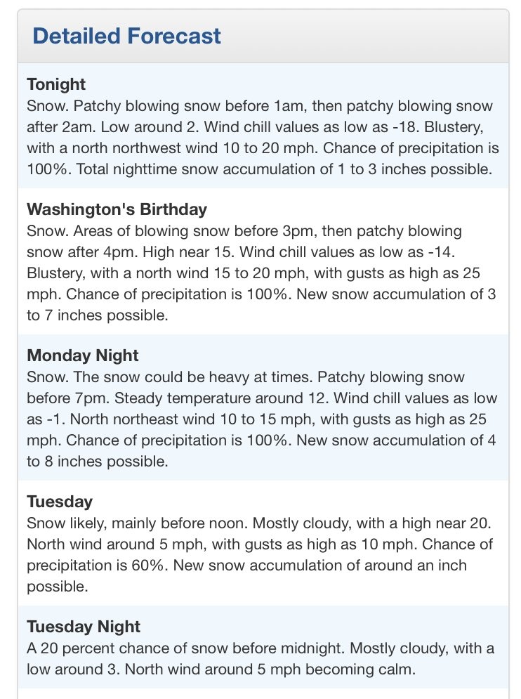
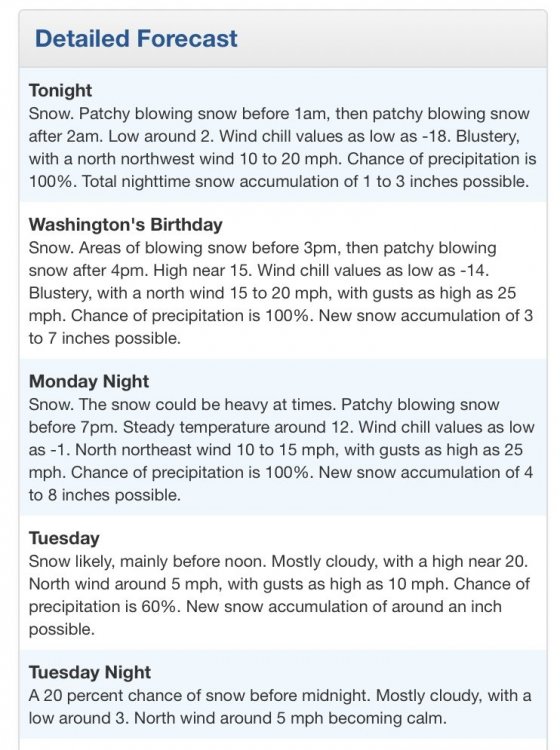
Flood Watch National Weather Service Raleigh NC 345 PM EDT Wed May 20 2020 ...FLASH FLOOD WATCH REMAINS IN EFFECT THROUGH THURSDAY EVENING... .A slow-moving upper level low over the Tennessee Valley will result in multiple rounds of moderate to heavy rainfall with embedded thunderstorms through Thursday night. Many areas over the western Piedmont have already received 1-3 inches of rain, resulting in increased flow in creeks and streams. Additional rainfall of up to 2-5 inches will lead to localized flash flood and minor flooding on main stem rivers. NCZ007-024-025-041-042-078-089-220000- /O.EXA.KRAH.FF.A.0001.000000T0000Z-200522T0000Z/ /00000.0.ER.000000T0000Z.000000T0000Z.000000T0000Z.OO/ Person-Orange-Durham-Wake-Johnston-Wayne-Sampson- Including the cities of Roxboro, Hillsborough, Chapel Hill, Carrboro, Durham, Rougemont, Raleigh, Cary, Apex, Wake Forest, Knightdale, Smithfield, Selma, Clayton, Goldsboro, Clinton, and Roseboro 345 PM EDT Wed May 20 2020 ...FLASH FLOOD WATCH IN EFFECT THROUGH THURSDAY EVENING... The National Weather Service in Raleigh has expanded the * Flash Flood Watch to include a portion of central North Carolina, including the following areas, Durham, Johnston, Orange, Person, Sampson, Wake, and Wayne. * Through Thursday evening * Multiple rounds of moderate to heavy rain will result in additional rainfall amounts of 2 to 3 inches, with locally higher amounts around 4 inches possible over the western Piedmont. * Rapid rises on creeks and streams, as well as flooding of low- level areas, may occur, especially in urban areas. PRECAUTIONARY/PREPAREDNESS ACTIONS... A flash flood watch means that conditions may develop that lead to flash flooding. Flash flooding is a very dangerous situation. Monitor later forecasts and be prepared to take action should flash flood warnings be issued.
-
looks like a new area of training showers is setting up ahead of the main batch of moisture. we already have a little over 2” storm total here in western Durham county and weren’t slated to get the heavy stuff until this evening. I wonder if RAH is finally going to pull the trigger for a FFW for counties further east.
-
March 26-28 Severe Threat
featherwx replied to Tim from Springfield (IL)'s topic in Lakes/Ohio Valley
if I’m in Chicago would it be worth driving a couple hours W/SW at this point to catch the action later? seems like the good stuff might stay even further away than that at this point... -
This is my fourth year in Lorain County and the cutoff between here and places just to the east in terms of LES accumulations still amazes me. We're forecasted for a run-of-the-mill 2-5" between today and Wednesday, while Cleveland (just 30 miles to the east) is slated for 10-18"!
-
The LES shaft job continues for the southern half of Lorain Co. The worst part is that areas to the west are even getting some of the Huron banding right now--salt in the wound.
-
Oberlin of course missed this morning's LES by only about 5 miles, but I'm optimistic that the Huron band can make up for it later today.
-
Got ~0.5" in total since yesterday and it's all but melted over the last few hours.
-
Hoping this thing can shift south just the slightest bit--I'm probably less than a mile south of 1-2"/hour rates right now getting nothing.
-
got ~3" this morning, plus an inch last night
-
Getting dumped on under a nice band that looks to be training over this area. Nice surprise to wake up to! Edit: Essentially white-out conditions right now, even without any wind. Pretty rare treat for those of us east of CLE!
-
Picked up a quick 2-3" this morning when the band raced through. Definitely only a fraction of what folks nearby got, but I'm very satisfied nonetheless!
-
CLE: .SHORT TERM /6 PM THIS EVENING THROUGH TUESDAY NIGHT/... The upper trough will move east of the area tonight with the coldest air of the past couple of weeks descending over the area. 850 mb temps will dip to neg 11 or colder by 12z Sunday and eventually to around neg 14 during the day. Winds will become favorable for lake effect to resume overnight. Forecast soundings still showing some shear and moisture isn`t all that great. See no need for any headlines at this point and will continue with 2 to 4 inches tonight and a couple more Sunday over NW PA. The models are also hinting at a Lake Michigan band possibly getting set up over the secondary snowbelt by early Sunday. Will go with likely or better precip chances that area but will keep accums down to an inch or two for now.
-
I feel ya buddy!
-
Returns are really lighting up over Lorain county right now. Is this due to lake enhancement? (please excuse my ignorance)