BeauDodson
-
Posts
417 -
Joined
-
Last visited
About BeauDodson

- Birthday May 8
-

Summer 2024 Medium/Long Range Discussion
BeauDodson replied to Chicago Storm's topic in Lakes/Ohio Valley
They batted about 80% last year with long-range outlooks. They have come a long way since their infancy years ago. Their farm and garden videos, GFS analysis, and EC analysis videos are excellent. They have an amazing team of meteorologists. Years ago, I felt the same way. But, over time, they have become a great company!
-
Summer 2024 Medium/Long Range Discussion
BeauDodson replied to Chicago Storm's topic in Lakes/Ohio Valley
You can see where the ridge set up shop over the last three weeks. The haves and have-nots. Too much rain and too little rain.
-
Summer 2024 Medium/Long Range Discussion
BeauDodson replied to Chicago Storm's topic in Lakes/Ohio Valley
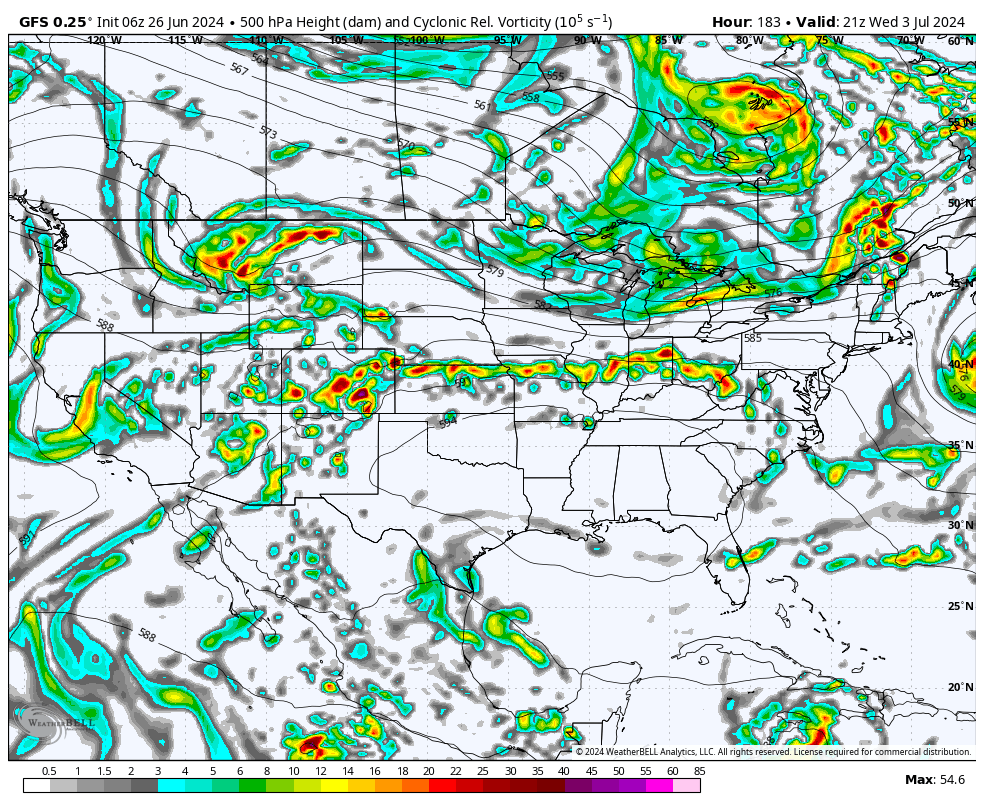
Our long-range team has a great video today about July's weather. A bit of a nail-biter for the Ohio Valley. We will have to see where the ridge sets up. Would not be surprised to see the MCS train produce pockets of ten or more inches of rain. These videos can be viewed on our www.weathertalk.com app. If you don't live in our area, then choose any given county and then download the app to view the daily videos. -
Historic Lake Effect Event?! 11/17-11/21
BeauDodson replied to BuffaloWeather's topic in Upstate New York/Pennsylvania
It appears the GOV is closing most roads at 4 PM. That shuts me out. Disappointed, but it is what it is. I have to be at NWS conference this morning. Otherwise, I would have left last night. Be careful, everyone. Enjoy the white gold. Looking forward to the photos and videos. -
Historic Lake Effect Event?! 11/17-11/21
BeauDodson replied to BuffaloWeather's topic in Upstate New York/Pennsylvania
What Discord room is that? Thanks -
Historic Lake Effect Event?! 11/17-11/21
BeauDodson replied to BuffaloWeather's topic in Upstate New York/Pennsylvania
Hoping I can come in from the south tomorrow afternoon. Sounds like they will close it. Unsure another way in.
-
Historic Lake Effect Event?! 11/17-11/21
BeauDodson replied to BuffaloWeather's topic in Upstate New York/Pennsylvania
What are you driving once there? -
Historic Lake Effect Event?! 11/17-11/21
BeauDodson replied to BuffaloWeather's topic in Upstate New York/Pennsylvania
Interesting setup for LES. I remember the 2000 event. Incredible totals. Quite a bit of thundersnow. I'm thinking about chasing this one. -
Winter 2022/23 Short/Medium Range Discussion
BeauDodson replied to Chicago Storm's topic in Lakes/Ohio Valley
Is this the correct thread for the Buffalo area? Thanks -
Devastating tornado strikes Joplin, Missouri
BeauDodson replied to Hoosier's topic in Weather Forecasting and Discussion
Hi JoMo, I thought about you on the anniversary of the tornado. It is hard to believe that it has been ten years. It seems like yesterday. I don't come on the forums very often, but was browsing it this morning and noticed this thread was still active. I hope you are doing well. I can't imagine the amount of trauma associated with an event like this. I can only compare it to what I saw after Katrina and Rita. It is hard to fathom so much destruction and loss of life. -
Thank you
-
It is amazing how many days many areas have been at or above flood stage. Over one-hundred days in many areas. Is this the main Barry thread?
-
2019 Short/Medium Range Severe Weather Thread
BeauDodson replied to snowlover2's topic in Lakes/Ohio Valley
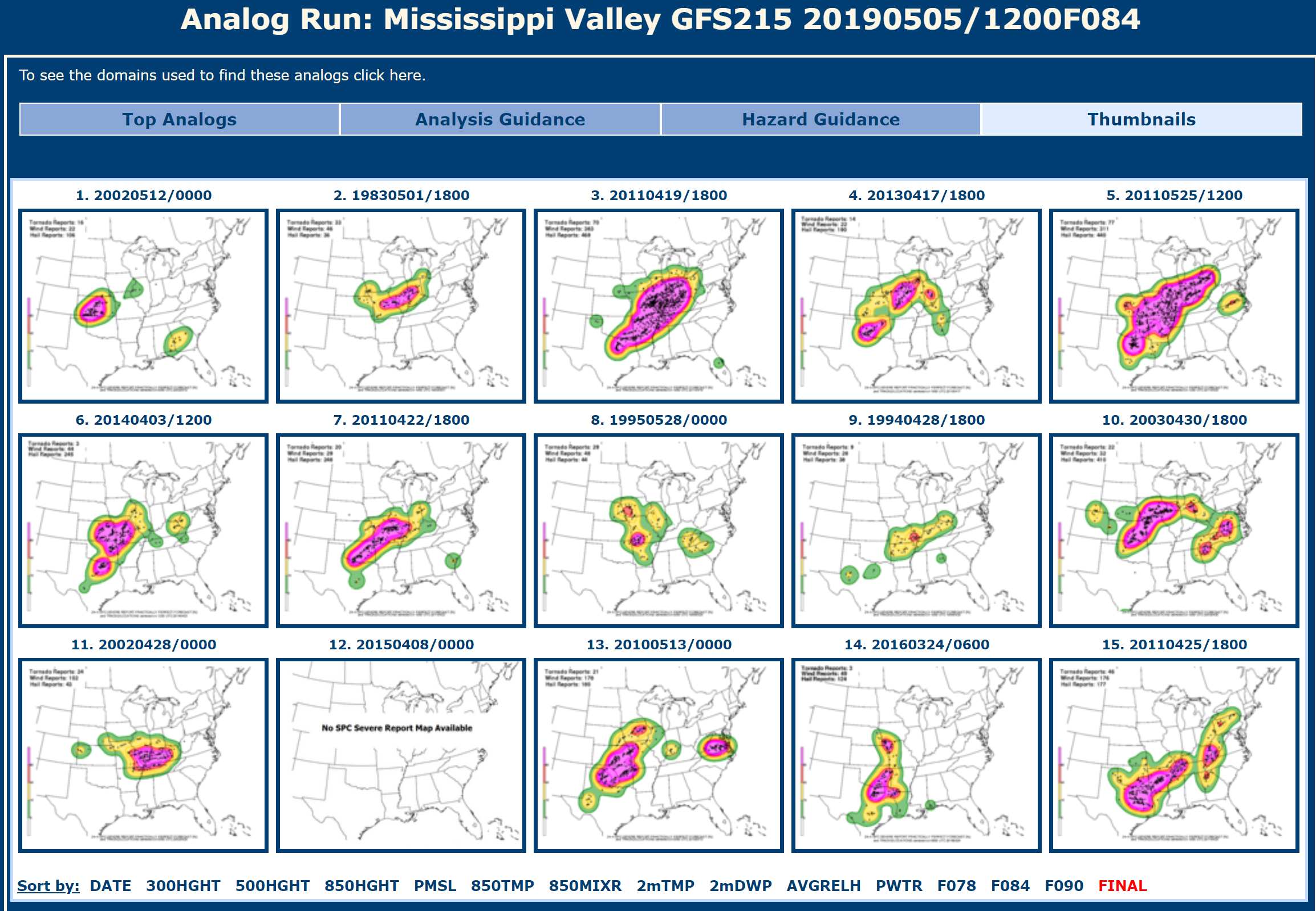
CIPS analogs are showing some decent events. http://www.eas.slu.edu/CIPS/ANALOG/DFHR.php?reg=MV&fhr=F084&rundt=2019050512&map=thbPPF This is the near perfect forecast graphic set. Wednesday and Thursday have some potential but, as always, is highly dependent on what happens with the dying MCS's. So far this year, our region has had numerous conditional events. Meaning, the forecast has been low confidence because of ongoing rain and clouds. The two tornado events were poorly forecast. One tornado event did not have a watch and was in the general thunderstorm forecast zone. Our last tornado event was on May 2nd. That was under-forecast, as well. It will be interesting to see if we can pull off a region-wide event this week. Most of the events have been localized, thus far.
-
Love your site.
-
Devastating tornado strikes Joplin, Missouri
BeauDodson replied to Hoosier's topic in Weather Forecasting and Discussion
Was thinking about you today. Popped into the forum to see if this thread was still alive and well. I see that it is. I agree, it is hard to believe that it has been five years. Hope you are doing well.