JetsPens87
-
Posts
1,105 -
Joined
-
Last visited
Content Type
Profiles
Blogs
Forums
American Weather
Media Demo
Store
Gallery
Everything posted by JetsPens87
-
Thanks I'll take a look.
-
Proof of that?
-
I'd venture quite a few of those years had either N or BN precipitation and the lack of snow may have been more a function of that. It's more evident that the recent snow drought is a function of well AN temperatures. I don't have the data to back this so it's just speculation but it's clear that the scorched earth is a huge implication in recent history.
-
As it's 70 plus degrees today
-
The update we've all been waiting for...
-
Feels more humid today too
-
Thanks! I feel like I've aged 10 years in two lol
-
Thanks rjay. I've been on hiatus from weather boards for 2 years almost (twins will take up some time hah). Tried to go back to the 'other' and it's insufferable.
-
Hi ag3. It's Snow Wolf. You'll be happy to know that the other board still allows no dissenting opinions. I got chewed out by the crazies for not liking the fantasy day 10 plus crap popping up periodically. I'll post here some more.
-
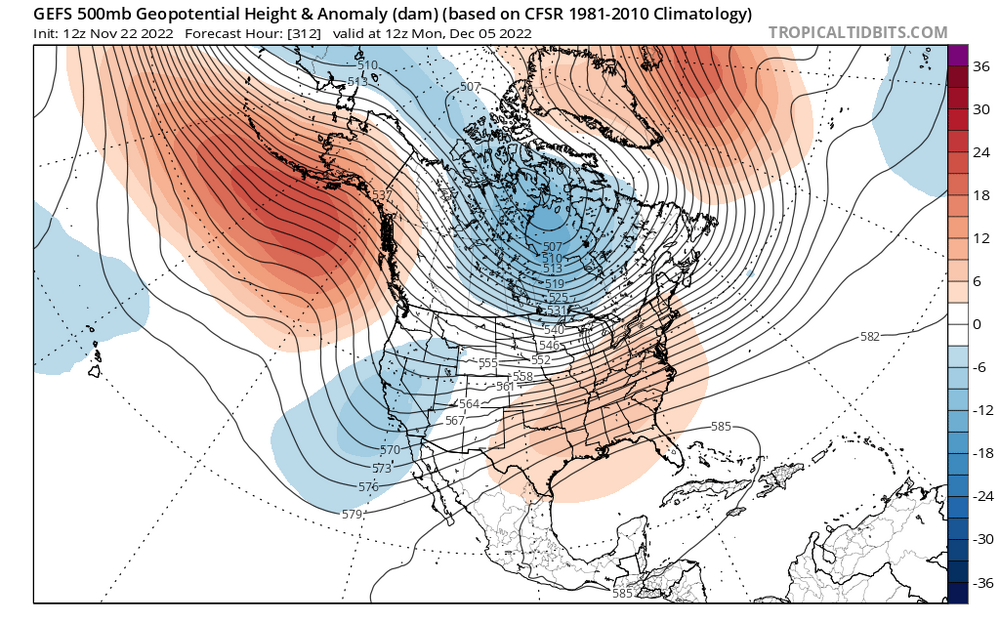
Yup! Thanks for posting this. Looks like a clear reflection of all the energy diving into the SW in the near to mid range. What are your thoughts as we move into the second week of Dec?
-
I agree with John. We must wait until the second week of Dec to see a big shift. It is showing up on ensembles with the SW trough muting in response to the PV being shunted into SE Canada. I have my eye on a major archambault style event the second week of Dec. A true wave breaking event based on recent ensemble guidance. Just hang tight folks, there are Legitimate signs of a PAC reshuffle being seen, something that has only been teased the past few winters but without any substance.
-
Would love to see all that energy eject from the SW and spike the PNA behind it. The EPO is trying to kick but with a 3rd year LA Nina yet again, it appears the spacing is unfavorably modeled at this point. PAC problems persist through the first week of Dec IMO. With that said, it's a pretty nice gradient pattern. That would certainly produce chances for New England.
-
To me forecasting in the medium range has always been about starting with the Pac. One look at the Pac and west coast and it raised huge red flags for me. When you have an ugly Pac with similar problems as in the past few winters (lower heights and LP sitting by the Pac NW it only serves to roll that ridge over as shown on cureent guidance. This essentially traps that energy and hems it up in the SW, exactly what we don't want because then heights Flux in the East. The 50 50 which is really not a helpful 50 50 here but I'll call it a 50 50 low, is too displaced to help alleviate some of that height Flux in between our threat and the 50 50. I had mentioned prior that if that feature were further SW then we could establish some confluence in New England and we would at worst be hoping for a SWFE trying to push that under. It just strikes as an ugly setup and it appears to be getting uglier unfortunately if you are hoping for snow in the northeast.
-
This is really interesting. And I never really thought of it. Of course there was the Halloween bomb, and son of sandy, but yes come to think of it...nothing sticks out in my mind for the second hf of November. It really doesn't pickup again until the infamous Dec 5th date.
-
Really needed/need the 50 50 further SW. Thats really it...without that there is no confluence over New England to prevent this from riding inland or the coast. There is too much high height potential in between our threat and the 50 50. No mechanism to drive down cold air, and not much available with a somewhat ugly PAC. That ridge rolls over and you are only able to get a shallow cold air mass, can't establish an arctic fetch with that. Could this change? Yes and it will, but I believe it's becoming more evident that this is an interior threat. But there will be a storm.
-
Wow. I didn't stay up to monitor it overnight. They got slammed!
-
Ironically another band set up just N of the city proper now. Didn't see if it was the same band that moved N there but the city itself just can't seem to "win" here hah
-
Wow! I also hail from Warren county but have never heard of marksboro lmao.
-
Thanks! It has been a couple years. Major life events have really taken precedence.
-
I am actually really excited for this. Even being in Monmouth county I think with it coming down as hard as it looks like it may, it should be at least our first wintry precip here this season.