JetsPens87
-
Posts
1,105 -
Joined
-
Last visited
Content Type
Profiles
Blogs
Forums
American Weather
Media Demo
Store
Gallery
Everything posted by JetsPens87
-
Blizzard that sticks around for awhile? Probably Blizzard instantly wiped out by a sea of warmth otherwise? Probably not over this year.
-
To me it actually felt like we had a winter this year. A winter season. I'd rather have this than a one or two week period of 'winter' with a larger storm surrounded by warmth.
-
Climo still on our side Persistence would dictate a continuance of BN Upstream you still have the EPO press driving cold through Canada. Downstream you have the PV spinning it through SE Canada and into the Northeast This continues through mid March IMO
-
Not sure how anyone looks out through March 10th - 15th ish and doesn't think winter continues through there. After that? I think it flips REALLY quick to warmth but even that timing is still up in the air.
-
 I have zero respect for DT Not sorry
 -
Yes but please keep in mind you're asking for a feeling not a forecast here. It's not a high bar to achieve right now and I think we get a shot at one very large event (possibly more) as the PV looks to eventually retreat. Go ahead and put your poop emoji. Idc.
-
I actually don't think I chimed in on that. My thoughts on the EPO are that we are struggling with the PAC even given that EPO. Ringing has been displaced W and there has been consistent pesky poorly timed energy dismantling these ridges given the fast Pac flow which has cursed us for 3 plus years now.
-
CFS Weekly show the PV staying put until week 4 until it (abruptly) retreats W and allows heights to spike in the E. That evolution given background state seems abrupt to me and I'd expect it later week 4 and beyond. I'm also not really as knowledgeable in the long range so take that fwiw. Just being honest.
-
It's very hard for me to envision any sort of sustained warmth in the next 2 to 4 weeks.
-
Please don't conflate me not believing this is a startling 'bust' per se with me thinking the models are never wrong.
-
It's just hard for me to get worked up over a miss from 5 days out. It would have taken another 24 hours of model cycling to have made this really credible in the first place IMO.
-
And this is happening one way or another... Just not for us. Don't get what you're saying. They never had it for more than a few cycles. I don't really find this to be that stunning of a model collapse when it was over 5 days out.
-
Please re read your post. FRIDAY. From Fri everyone latched onto a few crazy runs at almost a WEEK out. That's their fault. No respectable met ever called for a HECS that early.
-
Agreed People act like the models have no idea whatsoever. This event was literally telegraphed from 5 days out minus a few hiccup runs that the weenies all latched onto. It's not our fault people don't know how to use the tools
-
Excellent post
-
You'll still have Metfan and Neg Nao arguing until Dec 21 2032 the magnetic pole will tug it north
-
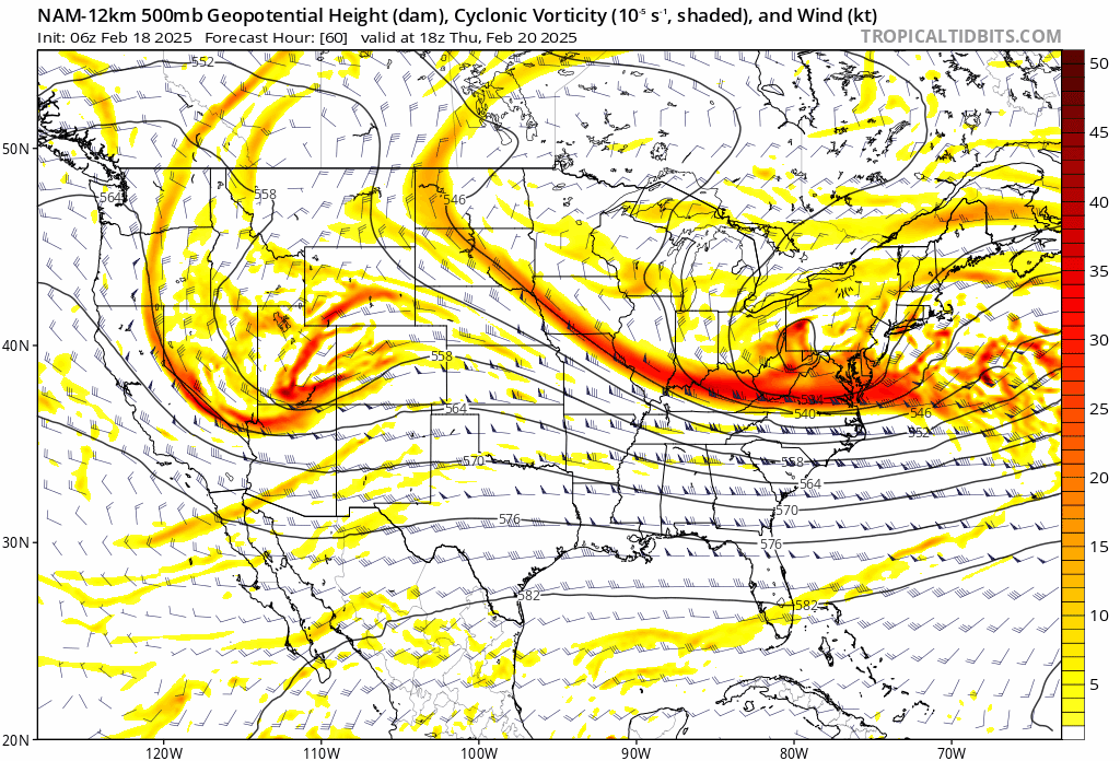
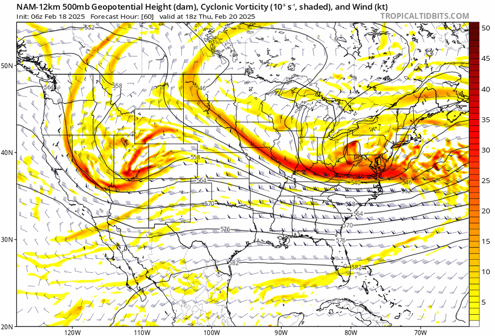
ULL/IVT snows may produce light snows for some but that area will be tough to pin down as IVT usually are finicky. But please don't tell me the SFC evolution isn't handled well (and has largely been outside of some early whacko runs) at this point.
-
There's not one piece of modeling left suggesting notable snows coming N at this point with the NAM caving. Are we allowed to say we have a handle on this yet?
-
It's Feb 18th...calm down
-
You'd need quite a bit more than 1 12k NAM run to change any forecasts agreed
-
I wouldn't use the 12k NAM as a standalone forecast tool if my life depended on it. Just sharing.
-
Also note the Wrn energy is held back. That allows the entrance jet into the trough to be much stronger and thus a more amplified ULL and further S ULL which allows the scenario above.
-
How's it do it? The NAM gets the ULL further S and underneath the SFC LP latitude. That allows the ULL to drive up heights slightly and 'push' the SFC LP further N while tugging on it.
-
What's the airport at officially though