Carvers Gap
-
Posts
15,647 -
Joined
-
Last visited
Content Type
Profiles
Blogs
Forums
American Weather
Media Demo
Store
Gallery
Everything posted by Carvers Gap
-
Impressive and thanks for the information and the share. That is A LOT of compost volume standing there.
-
Yeah, I was worried about that vetch...I already have it in my garden anyway! LOL. 120!? Wow. I assume you are hosting the TN Valley Wx Spaghetti dinner with that much tomato action! Keep us updated on the hemp situation. How do you market that? I am assuming that is the for the oil which is a big time product right now. Hey, at least you won't have to can all that hemp. Definitely going to need a pic of 10-12 foot plants!
-

Tennessee Valley 2019 Fall Speculation/Forecasting
Carvers Gap replied to AMZ8990's topic in Tennessee Valley
Still looks like a nice shot of cool air is going to be here around Labor Day weekend. Some divergence in modeling(understandably at that range) if the ridge in the East will return or be completely beat down post-Labor Day. I am probably 50/50 on that. Given our recent Fall patterns, the heat likely returns. With that big ridge(EPO?)popped over the western Pacific, it likely opens the door for at least some cool air to push periodically into the SE after Labor Day. It will depend on the amplitude of the downstream trough though. A higher amplitude trough puts the cooler air into the nation's mid-section...a broader trough at least gets seasonal to the spine of the Apps in regards to the post-Labor Day pattern. Basically, the skinny is that the ridge that has been so dominant of late is going to get pushed out to sea or at least to the coast by Labor Day. The question is whether the ridge returns to the East...sometimes modeling is correct in bringing back the original pattern and sometimes it is incorrect in trying to perpetuate the old pattern. The 0z EPS wants to have the ridge rebound while the GEFS is less enthusiastic...both within the bias of each model so who knows! Keep an eye on the ENSO thread, some good stuff in there. Also, Joe D'Aleo is definitely kicking around the idea that a turn to a BN pattern for the EC may return sometime in late Sept or early October. I tend to agree just based on some digging that I have done. But with the crazy Typoon Tip gradient in the Pacific, it is literally like trying to find your way through the dark...- 574 replies
-
- 3
-

-
- early winter
- leaves changing
- (and 3 more)
-
@Stovepipe, my garden remained fallow this year. Going to plant a fall cover crop which I have not done prior. Going to roll with a mix and see how it works. Likely will order some garlic as well...was awesome a couple of years ago. Here is what I am using...thoughts? Hey, and how has your gradient been this summer. I am glad to not be watering through this heat! https://www.johnnyseeds.com/farm-seed/cover-crop-mixes/fall-green-manure/fall-green-manure-mix-cover-crop-seed-2613.36.html Probably going to add some fall salad stuff and definitely some garlic.
-
Tennessee Valley 2019 Fall Speculation/Forecasting
Carvers Gap replied to AMZ8990's topic in Tennessee Valley
Fingers crossed that a nice little pattern change is being shown on the ensembles(GEFS, EPS) this morning. Maybe the first cold front of the season around Labor Day? Pattern change potentially arrives with that front as well. Big ridge goes up over the West and at the very least knocks down the heat over much of the East with maybe even coastal areas getting involved over time. Still 10+ days out there so everyone knows the rules(huge grain of salt). The 6z GFS would be pretty awesome for the first full football Saturday of the year. The potential for normal or slightly BN is something that a few folks have been kicking around for a week or two, so let's hope that comes to fruition...meaning fall like temps.- 574 replies
-
- 6
-
-
- early winter
- leaves changing
- (and 3 more)
-
Tennessee Valley 2019 Fall Speculation/Forecasting
Carvers Gap replied to AMZ8990's topic in Tennessee Valley
JB shared the Euro Weeklies through September...about as warm over NA as one can get in a LR model. Looking at Jax's Jan 2013 model and I thought it looked similar. Check out 2019 so far over the Lower 48. Pretty uncanny resemblance regarding the placement of warmth...also note that one is a 500 map and the other surface temp anomalies. In some ways, I think that pattern has been in place for about eight months already.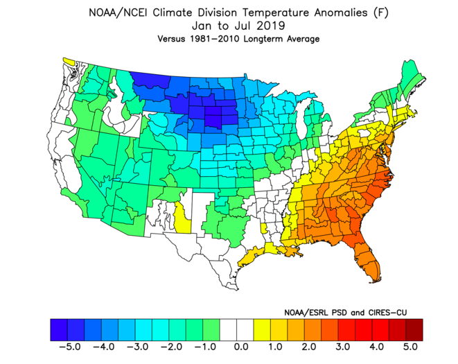
- 574 replies
-
- 1
-

-
- early winter
- leaves changing
- (and 3 more)
-
Tennessee Valley 2019 Fall Speculation/Forecasting
Carvers Gap replied to AMZ8990's topic in Tennessee Valley
Try this...let me know if it works. If not, I will grab some snippets. BTW, I am not completely sure what the ENSO is up to...I have a pretty detailed post in the ENSO thread. Jax has some good stuff their recently from the JAMSTEC. Hey, I now have access to Euro seasonal stuff!- 574 replies
-
- 1
-

-
- early winter
- leaves changing
- (and 3 more)
-
Tennessee Valley 2019 Fall Speculation/Forecasting
Carvers Gap replied to AMZ8990's topic in Tennessee Valley
It is free if you have Facebook. Just search for WxSouth. You know me...I will write a 5,000 word essay before teasing you all. LOL. I just didn't expound since it wasn't a pay site. Skinny...Thinks that a weak La Nina will be good...mentions TN as a being in a good spot. All speculation he freely admits. D'Aleo had a great post on WxBell today regarding the 93-94 analog going into fall. Thinks that OND will be BN in terms of temps. Also thinks that the cooler temps forecast in the LR over the northern Plains will eventually build into an eastern trough that becomes a mid-late fall stable pattern. I am tired of the heat...so I am freely stating that I am wish casting for a some cool fall weather...or at least just dream about it.- 574 replies
-
- 3
-
-

-
- early winter
- leaves changing
- (and 3 more)
-
Spring/Summer 2019 medium to long range discussion.
Carvers Gap replied to John1122's topic in Tennessee Valley
Joe D'Aleo had a great post on the Pacific setup potential leading to a colder OND about a week ago. He also mentioned the flooding today. Pretty uncanny how close the setup looks compared to July. Everything is slightly displaced, but similar features. Two inches of rain in twenty minutes! Holy Moly! -
Spring/Summer 2019 medium to long range discussion.
Carvers Gap replied to John1122's topic in Tennessee Valley
Thanks. I was out of the country during that summer as I shared in the ENSO thread. I put some analog stuff over there as well. The current Pacific set-up is quite similar to the summers of 93 and 05, though not a perfect match. They are also quite similar in how the ENSO pattern unfolded during the couple of years that preceded each. Anyway, so I noticed it was very dry here during '93. However, there was a strong precip anomaly(heavy rain) centered over the mid-West and eastern Plains. The similarity is that precip area is now displaced south and east this summer...and the MS river is has run full since spring, though not sure of its current status. The winter of '94 is the one I always forget in terms of cold, because Knoxville didn't get as much snow as the Plateau. However, the winter was reasonably severe in terms of cold outbreaks. I do think that might have been the winter where I got caught in a convective snow squall near the Cherry St exit - what a mess. Just kicking around some things during late summer. Thanks again for the info. I always say that I trust your climatology information over pretty much all other sources. -
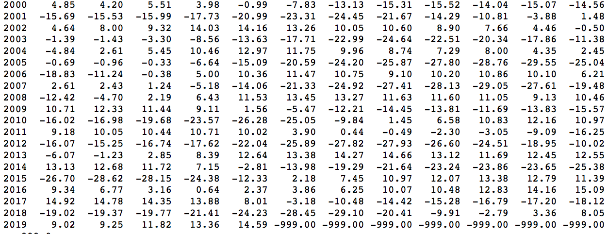
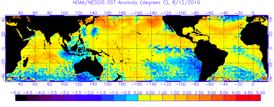
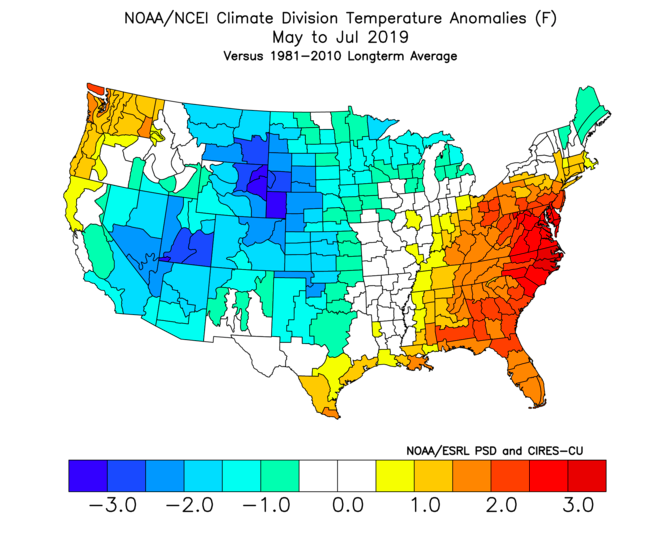
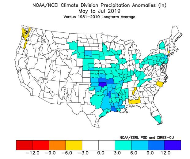
So in honor of me saying that analogs are likely untrustworthy as we approach the winter season, let's look at where we are today...or close to it. Oddly, I have tried to remember the summer of '93 and can't remember it. Well, there is a reason for that. I wasn't in North America! I was in the Middle East all summer(non-military). What I do remember is news of the Mississippi flooding. Anyway, I can find a few similar times to where we are now in terms of the ENSO cycle. 93-94, 95-96, and 05-06. 95-96 had more of a La Nina raging by August than now...so I am going to discard that for the moment. However, the summers of 93 and 05 looked fairly familiar in terms of the actually look of the SST temps vs comparing graphs. August 12, 2019 August 1993 August 16, 2005 Here are the composite temps for May through July for 1993/2005... and here is the precip map. Here is 2019... Plenty of similarities on the analog composites. 2019 has surface temps in similar areas but warmer. 2019 has AN precip in the nation's heartland but displaced further south and east. Both winters were wildly different but yielded normal to slightly BN temps over the TN Valley for winter. Where they were significantly different was over the northern Plains during the following winters. I didn't include that composite of the two analogs because they are so different that the composite map actually does a misrepresents the two winters. 05-06 is wildly warm over the Norther Plains and 93-94 is cold...almost opposites in those areas. That said, again, the SE is normal/cool during both. addendum: One can also not on the SST maps that the overall look of the 2019 Pacific map is warmer and is washing out the gradient in the northern hemisphere and might render moot the downstream ENSO implications over NA. Reference to Isotherm and TyphoonTip again.
-
Good stuff, Jax. IDK about the JAMSTEC. That is another big change in continuity for it. I generally like that model, but it struggled last winter as did the Euro Weeklies. If I had to bet, I think the regions closer to SA will be slightly BN in terms of SST and the regions to the West will be slightly AN. That seems to be a commonality at least for Fall on modeling. So, what I can't decide is whether that has a Modoki look or if it is a week Nina. I am beginning to subscribe to the idea that Robert from WxSouth is floating, and that is that typical ENSO patterns are not producing correlating results in relation to past analogs. I think the gradient will be the issue now in terms of SST(giving a nod to TyphoonTip). Pretty much the entire Pac basin is atypically warm. Now, Isotherm just posted(maybe on the main board now) about how the over-amped Pac may likely produce a very active Pacific jet. We saw that last winter as it just hammered the northern Rockies. I have never seen so much snow in my life(visited in late March last year)....they still had snow up to the second floors of their buildings on April 1st in West Yellowstone, MT. So, I wonder if we see another year with a very active Pacific jet. What I don't know is how the cooler water near SA is going to impact that fire hose. Does it buckle the jet(if so, where?) or does it just allow a zonal flow as this winter's norm? Also the warmer temps in the GOA are going to have to be reckoned with. Even if analogs could be used, seems like very few match the warm basin look along with the very warm water in the GOA. I have seen 93-94 kicked around and maybe 14-15...but do those analogs even work as there is very little gradient in the Pacific right now. I still think the mean trough is east of the Rockies(maybe up against the foothills on its westward extent) and is west of the Apps(maybe barely). I also think this winter is going to be similar to 17-18 in that it has extremes that tend to flip back and forth during winter. Hey, and great thread as always. Thanks for sharing those maps. Definitely not a boring ENSO look as it is sort of wild looking. I suspect we are in new territory right now in terms of the ENSO. This is when I would like to have an atmospheric physics degree(without having to put in all of that work to get it...LOL).
-
@Holston_River_Rambler pretty interesting to see the storms roll off Bays tonight. Looks like the winter time snow deal that you have studied some. The animation is pretty cool. Maybe a little lift from Bays Mtn which sits at 2300’ and maybe some lift from the industrial heat dome?
- 117 replies
-
- 1
-
-
- grieving winter
- hoping for sunshine
- (and 2 more)
-
Spring/Summer 2019 medium to long range discussion.
Carvers Gap replied to John1122's topic in Tennessee Valley
@John1122 did the summer and fall of 1993 have any resemblance to the current pattern? Saw that Newman on the main board said that 93-94 looked fairly similar in terms of ENSO. -
Spring/Summer 2019 medium to long range discussion.
Carvers Gap replied to John1122's topic in Tennessee Valley
There is a bit of irony as I type this, because a line of afternoon storms is approaching my location. Anyway, some other folks mentioned the ground surface beginning to dry. Man, my yard is baked. As we begin to see the ENSO moved towards a Nada or slightly less by maybe winter...the heat, reduced rainfall(Weeklies are ugly in terms of precip), and scorching temps show some tendencies towards La Nina climatology already. Scorching hot summers that never end along with a tendency towards a dry pattern(we have had less rain than the Plateau all summer) over E TN certainly appear to depict an atmosphere depcoupling with El Nino fairly rapidly. Weak La Nina's can be fickle in that they have extremes. I suspect we are about to enter a pattern where we go 4-6 weeks of really warm followed by 4-6 weeks of really cool. Robert had a great write-up on WxSouth regarding his upcoming winter thoughts on FB. Worth a read for sure. Basically, he mentioned that La Nina winters (or even slightly negative if I remember correctly) have been more conducive towards cold than weak El Nino winters which up until recently were money. States that he feels that a lean towards La Nina might be indicative over a cooler winter vs the El Nino which now seems to(at any level) release so much heat that the SE is AN. All of that plays into the short range forecast for the next few weeks as it looks very warm and very dry....even though MBY is about to get some much needed rainfall. -
Tennessee Valley 2019 Fall Speculation/Forecasting
Carvers Gap replied to AMZ8990's topic in Tennessee Valley
Robert has a post on WXSouth FB about different scenarios regarding the upcoming fall and winter...is a good write-up I think.- 574 replies
-
- 1
-
-
- early winter
- leaves changing
- (and 3 more)
-
And of course @AMZ8990...the man. Hey, we also occasionally get @Will (little rock) on this subform as well.
- 116 replies
-
- 3
-
-
- banter
- chewing the fat
- (and 5 more)
-
@mempho used to post some from that area. Believe he is on another forum now...good poster though.
- 116 replies
-
- 3
-
-
- banter
- chewing the fat
- (and 5 more)
-
Ventrice on Twitter is saying there is an issue with the CANSIPS August run...they are working on a fix per the MA sub-forum.
-
LOL. Yeah, I probably should have looked at that a bit more closely.
-
Good find. Interesting that it has an Nina for an SST and a trough in the East at 500. Weak La Nina's are not always bad in my neck of the woods. Strong Nina's are pretty much terrible. The weak ones produce some serious extremes in temps. About the only thing that limits snow amounts are years when weak La Ninas produce long spells of precip-less weeks. I do wonder if the atmosphere will experiences a very mild hangover from the El Nino early during the winter and then(Niña...edit) lock-in during late winter. The warm water near the GOA/NE PAC should cause an interesting PDO index. As mentioned in the pattern discussion thread, this year may not have a ton of analogs. Does the Cansips work with an analog package at that range? Interestingly, the Cansips has a fairly warm bias IMHO. So, that is an interesting 500 look. It would be pretty wild if the West gets a perfect setup and the cold goes East...would balance out last year where they got a ton of snow during a perfect set-up for the East.
-
Spring/Summer 2019 medium to long range discussion.
Carvers Gap replied to John1122's topic in Tennessee Valley
Thanks for the update. I have read recently that this is yet another year with very few analogs and even those years are debatable. QBO poised to fall. Nino quickly fading. Warm blob in the western Pacific. Low solar. Yeah, definitely looking forward to ball this year. Really hoping we can get some non-hot-as-crap-fall weather earlier than later. LOL. The endless summer scenario is getting old like we have had during the past few years. But hey, the past couple of weeks have been exceptionally nice. Going to be interesting to see how the aforementioned indices will play this fall. -
Spring/Summer 2019 medium to long range discussion.
Carvers Gap replied to John1122's topic in Tennessee Valley
Ok, @nrgjeff. We looking at a La Nina this winter? Seems like the range is a Nada on the top end and a weak La Nina on the low end. I have a feeling that we have another winter that doesn't play nice(in terms of forecasting) on its way.... -
Spring/Summer 2019 medium to long range discussion.
Carvers Gap replied to John1122's topic in Tennessee Valley
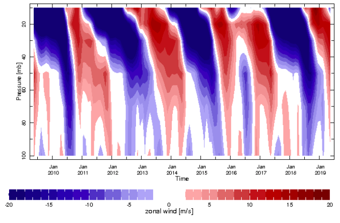
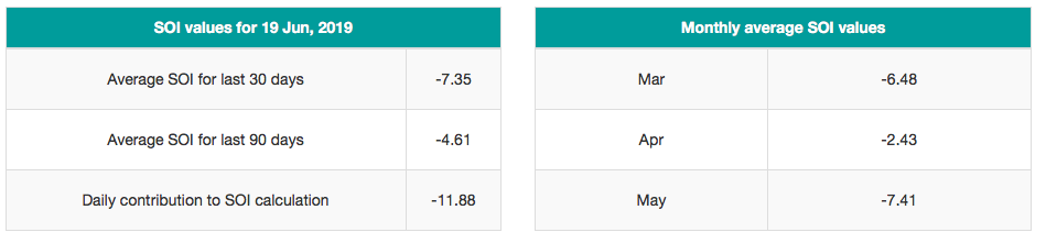
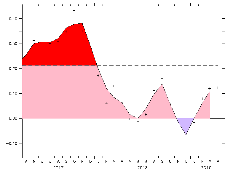
As Jeff would say, in the way out there....So, for kicks and giggles, here we go with some "much too early" upcoming winter thoughts. 1. First, the much debated QBO...The positive phase of the QBO tends to last 13-14 months. Assuming that it does not got crazy like the last positive cycle(an anomalously long positive cycle), we are about half way through the positive cycle. That means that we could possibly see the QBO flip negative during January or February. As Jeff has noted previously, it is the trend that matters. So it looks like the QBO will be positive but trending downward. Found a great graphic(does not include solar min influence...which does matter) in that regard. Looks like we will be in "C" - maybe a shot at "A" during the last half of winter. Last winter we basically were in "D". https://blog.weatherops.com/will-the-negative-qbo-increase-the-odds-for-a-colder-winter-this-year 2. Here is the latest QBO data. You can look at the flip that occurred last November. By roughly this upcoming December, it should have run its course. More importantly, it should be dropping by the beginning of winter. https://www.esrl.noaa.gov/psd/data/correlation/qbo.data 3. As for evidence that the QBO is in a phase change, take a look at the cross section of atmospheric winds for the QBO. Unless we have a double dip like the last cycle, one can notice the beginning of the flip in the very upper right hand corner of the graphic. See the blue peaking through near 20mb? That is the beginning of the "downwelling" of the next negative cycle. Again, please note that during the last cycle that the blue appeared and then regressed. The others were fairly clean flips. https://iridl.ldeo.columbia.edu/maproom/Global/Atm_Circulation/QBO.html 4. The SOI is now firmly negative which it was not during this past winter. It was positive and was a La Nina signal. https://beta.longpaddock.qld.gov.au/soi/ 5. Then, we have the solar min. Sunspot numbers have been bleak during the past several weeks. Today is another zero. https://sohowww.nascom.nasa.gov/sunspots/ 6. ENSO....Just looking at the latest ENSO predictions in Jax's superb ENSO thread, looks like the weak El Nino has a somewhat decent chance of making it into winter. Though, I did read that a Nada is statistically on the table as well....maybe a 1/3 chance for it? 7. Once last nugget...here is a plotter for various weather data. Beware, you might be there a while once you start browsing. Just have to create a log-in. https://mrcc.illinois.edu/CLIMATE/index.jsp 8. Addendum. Meant to throw this into the mix and forgot. The AMO is still positive(positive phase correlates to warm winters in the East) , though it did make a quick, almost statistically insignificant dip into negative territory last winter. It does make me wonder if the downward trajectory correlated somewhat to the cold November last year. Then, during this past December it rebounded at about the same time that we flipped warm. Something to think about. At some point this will flip consistently negative, but that is difficult to predict in yearly increments - probably will flip sometime during the next 5-10 years. https://stateoftheocean.osmc.noaa.gov/atm/amo.php Summary: Let me state this post is not a prediction, but merely speculation(and maybe even wild speculation given the relative time frame to the upcoming winter). It is admittedly tough to nail down 3-4 week predictions, much less seasons stabs made during early summer. Until we know the ENSO state for winter(October and November will give us a solid look), any prediction would have very low skill. So, just speculation for DJF. As of right now...looks like a weak to very weak El Nino...maybe even a Nada. It does appear that the NA weather pattern is now actually coupled with the ENSO state as evidenced by a lack of predicted heat waves and decent amounts of rain - finally.(Spring was a scorcher) The solar cycle is approaching what could be a series of cycles that will be classified as a "minimum." The QBO "should" be falling(trending towards negative) as next winter opens. Past that, I am sure there is some index(if not our very latitude) that will likely make every attempt to "screw us" out of a good winter...please reference the over active MJO of 18-19. JB has noted this week that the effects of Super Ninos have lingered several winter seasons after each significant event. I think that supports what some have noted as a current warm climate signal, please reference comments from last winter(TyphoonTip I think) about the basin wide Pacific temp gradient(entire basin was warmer than normal) and how it can actually wash-out a weak El Nino signal. So, early prognostication would seem to at least show a "lean" towards a trough in the East for Jan/Feb with a classic El Nino backloaded winter...unless the MJO can't settle down. If that happens, just expect an ugly winter(maybe just do that anyway and be pleasantly surprised if wrong. LOL.). So maybe an early winter for those in the West and a decent January/February for those in the East west of the Apps. Also, it has been a while since we have seen a good old fashioned winter where all of the NA continent(full latitude trough) was base cold for much of the winter...will we ever see that again? Lastly, what we don't know is where the worst of the cold will set-up in the northern hemisphere for winter. We may not know that for some time and might not even be known until the hemispheric winter pattern actually establishes itself. Remember, sometimes we can have a great pattern but the actual cold stays in Siberia...and doesn't fill the eastern trough. We really need the AMO to go negative and stay there very several years.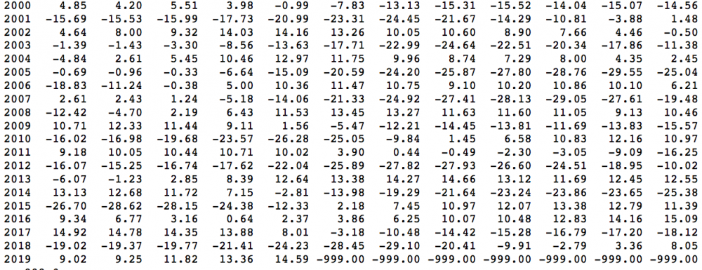
-
Spring/Summer 2019 medium to long range discussion.
Carvers Gap replied to John1122's topic in Tennessee Valley
I am digging this non...90 degree, oppressive mega heat ridge pattern. Been pleasant up at TRI today. Was out West last week and feels remarkably similar...minus the humidity of course. I go running at 6,000'. Folks ask me if it is difficult. I always tell them that the first couple of days are tough, but the low humidity out there and cool mornings are like paradise. I can generally run 1/3 more than I do here once acclimated. When I get home, breathing at long distance is easier, but the heat is just withering. It has snowed about 8,000' several times since last weekend...the day after I left of course! While we were out there, got a wicked thunderstorm that took shingles off of rooftops. Pretty rare out there since most of those roofs are rated for high winds.