

Carvers Gap
-
Posts
15,647 -
Joined
-
Last visited
Content Type
Profiles
Blogs
Forums
American Weather
Media Demo
Store
Gallery
Everything posted by Carvers Gap
-
A fifth record high for September in now in the books at TRI hit a whopping 92 on September 16th. For some of you further south that might not sound too bad...up here that is pretty much as out of bounds as one get as evidenced by the record. Looks like there may be more chances for records to fall next weekend and early into the next week. Oddly, none of the 1954 record highs have fallen....just picking low hanging fruit right now by setting records on the other days. LOL....yeah, even the low hanging fruit is still hot!
-
Sitting at 25 days straight with no rainfall. On the other side of town this week, there was a brief shower that wet the streets(barely)...nothing here.
-

Tennessee Valley 2019 Fall Speculation/Forecasting
Carvers Gap replied to AMZ8990's topic in Tennessee Valley
Interesting. Was that the year that NE TN had a ton of snow...but the Plateau kept missing out? Seems like during one of those winters of that timeframe it snowed like crazy here...and might have been BN for you all. Hope that does not happen this year BTW...just trying to place that winter. -
Tennessee Valley 2019 Fall Speculation/Forecasting
Carvers Gap replied to AMZ8990's topic in Tennessee Valley
Interesting. I have seen the 14-15 analog kicked around some...maybe by JB or D'Aleo. I am too lazy to look, but was that a La Nina year? I know Jax mentioned this in the main board ENSO thread(and I agree) this heat and flip to almost no precip is almost like La Nina. -
Tennessee Valley 2019 Fall Speculation/Forecasting
Carvers Gap replied to AMZ8990's topic in Tennessee Valley
Following up on Jax's post...the Weeklies are just brutal in regards to temps and precip. The worst warm temp anomalies for the Lower 48 are over the TN Valley. The worst temp anomalies are over western North Carolina where the usual brown color scheme for the worst precip departures is now actually shades of red. Maybe there have a slow breakdown of the pattern. However, as Jaxnoted, almost every time this pattern is modeled to break down...it doesn't verify. Admittedly, the Euro Weeklies are prone to follow the forecast they are derived from, and almost assuredly, they will actually miss the eventual pattern change. But ya'll, this temp pattern(minus some noted breaks...the potential drought is a new feature) has been absolutely locked into place since the second week of December! My rule of thumb is that a pattern lasts around 4-6 weeks. Been a very long time since I have seen a temp pattern survive this long. That monster SER has been locked into place and maybe by November it shows some weakness. That is the warmest set of Weeklies I think that I have ever seen. Hopefully, the will be as wrong as they were last winter. But we know the rule...warm always verifies. That will be my only Weeklies updated until the pattern shows some changes....nobody want to hear my play by play of increasingly warm temps.- 574 replies
-
- 1
-

-
- early winter
- leaves changing
- (and 3 more)
-
Tennessee Valley 2019 Fall Speculation/Forecasting
Carvers Gap replied to AMZ8990's topic in Tennessee Valley
It does look like another near-record warm, air mass will approach our forum area beginning on Saturday. The record high at TRI on Sunday is 90 and that is our forecast high. The record highs for the few days after that look like they are just out of reach, but there are a few later in the month that are reachable. Wouldn't surprise me to see us set another record or two before this next air mass leaves us. Meanwhile, enjoy today...about perfect compared to recent weeks. -
Tennessee Valley 2019 Fall Speculation/Forecasting
Carvers Gap replied to AMZ8990's topic in Tennessee Valley
Kudos to the SE forum folks finding this. The CPC updated their maps today. Her are the OND, DJF, and JFM temp maps. My takeaways are: 1. This warm fall set-up is going to take some time to break down...but there is hope. Looking like a gradual step down from these wicked hot temps. 2. The persistent SER is reasonably absent from those outlooks. Looks like they favor a western ridge and central/Midwest trough setup developing with poor source regions fro cold. I do really like the JFM outlook. It is also good to keep in mind that they rarely forecast large areas of cold at LR. It is also of note that they do forecast colder areas at 30 day ranges...and those are absent which jives with recent Euro Weeklies and Seasonal model runs. I have a tendency not to look at temps, but to try to look at where they think the ridge/trough placement will be which is usually indicated by these types of maps. Wherever the trough sets up is where the cold will likely setup...again the severity of which we don't know due to source region temps being fickle to predict at this range. 3. Unless I missed something flipping through the maps quickly, precip is normal in our subform area w AN along the northern tier of the US. 4. They have a couple of great writeups. Here is the 30 day discussion link: https://www.cpc.ncep.noaa.gov/products/predictions/long_range/fxus07.html . Here is the 90 day long lead: https://www.cpc.ncep.noaa.gov/products/predictions/long_range/fxus05.html. Those discussions connect really well to discussions that we have had in multiple threads among multiple posters.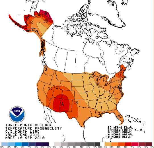
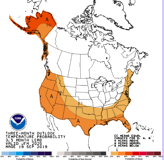
- 574 replies
-
- 2
-

-

-
- early winter
- leaves changing
- (and 3 more)
-
Have a few things that I wanted to share with this photo....First, you can see just how dry MBY is. Normally, it is a full and a lush green. Since it is south facing, it can get admittedly a but scruffy at this time of year. But this is well past being scruffy and about as bad as it gets. Second, you can see the leaves changing. Third, @Stovepipe, you can see the mustard greens, lettuce and cover crops chugging away. We water those which is why they are green. Lastly, it is thankfully cloudy! If we do indeed go a couple of more weeks with very little rain, we have a "before" pic now.
- 179 replies
-
- 1
-
-
- record heat
- transition
- (and 4 more)
-
Tennessee Valley 2019 Fall Speculation/Forecasting
Carvers Gap replied to AMZ8990's topic in Tennessee Valley
That was an interesting run. Huge winter storm over the lee of the northern Rockies mid-run. Three to four feet in the Crazies and Beartooths of southwest MT. Would be nice to see that feature. It has hinted at early northern Rockies snowstorms during past runs intermittently. That would at least shake-up the pattern.- 574 replies
-
- 1
-
-
- early winter
- leaves changing
- (and 3 more)
-
Tennessee Valley 2019 Fall Speculation/Forecasting
Carvers Gap replied to AMZ8990's topic in Tennessee Valley
12z operationals and ensembles pretty much bone dry for NE TN with the exception of maybe getting total of a .1". I have not received rain for 21 days. If we go 16 more, that is going to get pretty sketchy. The likelihood of me having 0.00" of precip for September is a possibility....have to think we at least get something. The heat ridge on the EPS is brutal to the point it is not even worth talking about. The operational does have some very brief cool downs followed by more heat. Nothing like dry frontal passages.- 574 replies
-
- 1
-
-
- early winter
- leaves changing
- (and 3 more)
-
Tennessee Valley 2019 Fall Speculation/Forecasting
Carvers Gap replied to AMZ8990's topic in Tennessee Valley
I linked the Wildlands fire danger map below - there are several variations of threats and data on the left menu bar. Plenty to look at and interesting for sure. I am not aware of any significant fires at the moment. We have had just enough rainfall to keep the worst conditions at bay. What we don't want are high winds to go with the high temps...dries things out in a hurry. Though we are not out West and our fire season does not really have a ton of similarities to theirs...sometimes wet springs can accentuate the following fire season or two due to more growth(fuel) than average. I agree with Jeff that the danger is not there at the moment, but the precip forecast is bleak. Total accumulate precip for the 16day noon run of the GFS is .2-.3 for most of NE TN with a few spots modeled to get .3-.4. Keep in mind that IMBY we have already gone twenty days with no appreciable rainfall(might have had one day with sprinkles that barely did more than stir the dust). If the GFS is right(LOL...how many times have we said that in our lifetimes), that would be almost a month straight with no rainfall. The CMC through 240 is about the same with just a few hundredths forecast for NE TN. Thank goodness for replenished aquifers or this would be pretty bad. Low humidity with record or near record temps.... https://www.wfas.net/index.php/fire-danger-rating-fire-potential--danger-32/north-america-fire-danger-map/92-sfwpinterface- 574 replies
-
- 2
-
-
- early winter
- leaves changing
- (and 3 more)
-
Tennessee Valley 2019 Fall Speculation/Forecasting
Carvers Gap replied to AMZ8990's topic in Tennessee Valley
I wonder if that is driven by the tropics(GOM origin)? A couple of recent runs of the GFS have also been trying to leave a cutoff over the nation's midsection as well which slowly meanders eastward. The last week of September is a slight relaxation of the SER pattern. At the end of the last pattern relaxation in August, Dorian went through the Bahamas. So maybe, something is getting pulled in there. Another good find, Powell. Hope we see some precip from it. Definitely need it. -
Tennessee Valley 2019 Fall Speculation/Forecasting
Carvers Gap replied to AMZ8990's topic in Tennessee Valley
Good info. While not as dry as the fires that burned Gatlinburg(as that resulted from a summer long drought), it pretty alarming how dry things are right now and after a very wet spring. I guess the heat and low humidity is the culprit. WJHL I think had passed along the danger of brush fires. These really dry falls are bad business because there is so much dry fuel in the forest. The trees are also parched. I think John was saying that the northern Plateau is in better shape. Seems like it is the valley floor eastward to the Smokies. The only time my yard has looked worse was during that fall a few years back.- 574 replies
-
- 1
-
-
- early winter
- leaves changing
- (and 3 more)
-
Tennessee Valley 2019 Fall Speculation/Forecasting
Carvers Gap replied to AMZ8990's topic in Tennessee Valley
In all seriousness, if we don't get some rain there could be serious fire issues in the eastern valley....low humidity, not a ton of precip recently, and record warm temps. -
You should be good to go. I am kicking myself for not putting out a late season crop of beans. They would be loving this weather. My cool weather crops are doing OK despite the record heat. Maybe the days getting shorter and longer nights is giving them just enough of a break.
-
What was your final high for the day?
-
Sitting at 19 days straight without measurable precip IMBY. The airport received some late last week...not here. With all of this record heat and not precip...we are back to some rough looking lawns.
-
Tennessee Valley 2019 Fall Speculation/Forecasting
Carvers Gap replied to AMZ8990's topic in Tennessee Valley
12z EPS mean dumped every bit of the cold into the northern Rockies ad nauseam. It is a never ending pattern. I will say, I am not really a model basher...just frustrated with the relentless heat we are experiencing right now. It is far worse than anything that we experienced all summer relative to norms. Normal high tomorrow is 79 at TRI. Going to approach the record of 92 set in 1954...high is forecast to be 91. Looking forward to the "cool down" this week with highs in the mid-80s which are still 5-7 degrees above normal. Most years we would be complaining about highs in the mid-80s at this time of year...all relative I guess. One last nugget. The average temperature(high and lows averaged together was 75.2 for August. It is currently 76 for September. The average high for September is a whopping 90.2. During August it was only 87.2. I mean at some point this trajectory has to go down, right? At this point I have to laugh...I am going to be freezing my tail off when it finally gets cold. Maybe when the wavelengths change-up we will catch a break.- 574 replies
-
- 1
-
-
- early winter
- leaves changing
- (and 3 more)
-
Tennessee Valley 2019 Fall Speculation/Forecasting
Carvers Gap replied to AMZ8990's topic in Tennessee Valley
It is crazy that the same head fakes from last winter(admittedly haven't been watching much since April)are still presenting themselves in modeling. There was significant cooling signaled on modeling for this upcoming weekend(in the day 10-15)...likely to be maybe to verify as maybe one or two seasonal days at best(maybe not that), but mostly a miss. Lately, the Euro seems less inclined to take the bait of faux deepening troughs in the East....but it seems to miss the cold in the northern Plains. The GFS/GEFS...whew...has a pretty bad cold bias in the d10-15 range. I do know that d10-15 is sketchy at best, but at one point that time frame would give us a hint on modeling. Not so much right now. But yeah, you called it late last week...we'd be lucky to get back to the upper 80s or 90. Seems like warm fall temps in place are very tough to break these days, and that is sort of Nina-esque. We haven't had more than a sprinkle IMBY since the third week in August. East of I-26 has received a storm or two. Think the airport got .68(?) last week. Anyway, these warm temps and bone dry conditions have some Nina qualities here. With the SOI in the tank, sort of surprising there isn't more precip. Maybe we can steal some rain from a tropical system...or this might be a pretty rough ride here with extreme temps and not much rainfall. I do think when this flips...going to flip super cold(vs norms) similar to last November(no idea when this year) with not much transition in between it now appears. Until then...the furnace beckons.- 574 replies
-
- 1
-
-
- early winter
- leaves changing
- (and 3 more)
-
Whoa!!!!
-
Tennessee Valley 2019 Fall Speculation/Forecasting
Carvers Gap replied to AMZ8990's topic in Tennessee Valley
Beginning to look more and more like the extreme heat will exit by next weekend, but as we have seen for the several weeks...the strong cold fronts which are modeled to form long-lasting eastern troughs are tempered down to but mere seasonal frontal passages. I am not ready to throw in the towel yet, but my confidence is much lower that the ridge will hold in the West. As with the last cool off in August, nice temps potentially will be in place for the last week of the month of September with hints in LR ensembles that the trough over the northern Rockies will again return. But let's see what happens...at some point this pattern is going to change. When it does, modeling will likely try to perpetuate the old pattern and show a faux return of the old pattern. That said, the eastern ridge just really wants to return every, single time it has been knocked down for the past couple of nine months(excluding a few breaks in the pattern). The longer these AN temps persist, the likelihood of having very little fall increases...meaning a flip to much cooler temps at some point. When? Not sure. Let's see if modeling picks up those strong cold fronts again...sometimes modeling will lose a pattern only to regain it as it gets closer. This is the year of reversing bad mojo...the Jayhawks are doing their part. Now, if the wx pattern and the Vols will just do theirs!!!!- 574 replies
-
- 1
-
-
- early winter
- leaves changing
- (and 3 more)
-
That is crazy hot! I went back and looked at those analogs after you posted this. Looks like a pretty big drought in the south/southern Plains centered around eastern TX, Oklahoma, and the GC states if I am remembering the map correctly. We have managed to pull this year's heat off with above normal rainfall. That pattern flipped to a cold November during 1954. Temps were -4F to -6F BN over E TN for November after that heat dissipated. I will freeze my tail off if that happens.
-
Tennessee Valley 2019 Fall Speculation/Forecasting
Carvers Gap replied to AMZ8990's topic in Tennessee Valley
@nrgjeff, I thought the Euro Weeklies from last night looked fairly decent from the last week of September through October? I hadn't looked at them until now. Looks like some seasonal temps at least...OR are they just pushing back seasonal temps ad nauseam?- 574 replies
-
- 1
-
-
- early winter
- leaves changing
- (and 3 more)
-
Indeed we have set a fourth record high in a row at TRI. As of the 2:53PM reporting cycle, 95F was recorded. It breaks the old record of 94F. As a Tennessee football fan, it is never wise to ask, "It can't get any worse than this, right?" But, come-on...enough already with the heat! LOL. I just wonder how many records Sept 1954 held originally...have to think a few have been broken? Nine still standing...impressive. Well, in Sept 2019 we now hold four so far. I will have to check next week as there is one more push early in the week of hot temps.
- 179 replies
-
- 1
-
-
- record heat
- transition
- (and 4 more)
-
One more degree to go and we hit an extraordinary fourth record high in a row. Meanwhile, the areas above 7,000' feet out West saw their first snow of the season...*sigh*. 1954 has nine record highs for September for TRI including the all-time high for the month, and they also had four days in a row of record heat at least. Nine...
- 179 replies
-
- 1
-
-
- record heat
- transition
- (and 4 more)