

Carvers Gap
-
Posts
15,647 -
Joined
-
Last visited
Content Type
Profiles
Blogs
Forums
American Weather
Media Demo
Store
Gallery
Everything posted by Carvers Gap
-

Tennessee Valley 2019 Fall Speculation/Forecasting
Carvers Gap replied to AMZ8990's topic in Tennessee Valley
FWIW, the d10-15 EPS is pretty cold....time will tell.- 574 replies
-
- 1
-

-
- early winter
- leaves changing
- (and 3 more)
-
Tennessee Valley 2019 Fall Speculation/Forecasting
Carvers Gap replied to AMZ8990's topic in Tennessee Valley
Glad to have you posting on here. I look forward to more posts. -
Tennessee Valley 2019 Fall Speculation/Forecasting
Carvers Gap replied to AMZ8990's topic in Tennessee Valley
Some fun stats. TRI had 44 straight days of AN temps until yesterday when its departure was -2. During that same time frame, MBY(airport had a little more precip due to a few more showers) had just 0.1" rain. Saturday's high of 71 was TRI's coolest high temp since May 15th just looking quickly at things. Temps will likely be below normal to well below normal on Wednesday and Thursday and Friday with highs struggling to reach 60 on Thursday. Looks like Friday AM has an outside chance of scattered frost with lows approaching the mid30s. The high on Thursday will be nearly 30-35 degrees cooler than it was just two weeks ago. It has been a remarkable transition.- 574 replies
-
- 2
-
-
- early winter
- leaves changing
- (and 3 more)
-
Can I just say how awesome it is not have temperatures in the mid90s everyday? Feels like a million bucks out there. I am jealous of the frosty mornings, John. We might have a shot at scattered frost later this week here. First freeze and first frost may show up at the same time if we miss Thursday!
- 179 replies
-
- 1
-
-
- record heat
- transition
- (and 4 more)
-
Tennessee Valley 2019 Fall Speculation/Forecasting
Carvers Gap replied to AMZ8990's topic in Tennessee Valley
Very good points about the PDO. I do think the SST gradient is making some usually dependable indices less dependable. Also, agree that the -AMO did help to offset the POD during the 70s. It is a good example of how a favorable Atlantic can really help. Also, good points by John about the EPO. Going to be interesting last to which drivers really have the most influence. Last winter, my ideas were actually warmer than most forecasts even with my backloaded winter idea, but not still not anywhere close to being warm enough. If the Weeklies from last night verified, I would feel really good about winter...but no way I am dying on that hill just yet(meaning one run of the Weeklies). LOL. Seriously, the discussion on this page has been stellar.- 574 replies
-
- 1
-
-
- early winter
- leaves changing
- (and 3 more)
-
Tennessee Valley 2019 Fall Speculation/Forecasting
Carvers Gap replied to AMZ8990's topic in Tennessee Valley
As for winter...man, I was tired last night and hope my posts weren't too disconnected. Shew. Anyway, winter at this latitude and elevation has never been a slam dunk. It is really going to depend on whether cold air and moisture get into the pattern at the same time. Bad patterns can produce snow and good patterns can be snowless. So really, at this range we can only guess the pattern. Last winter looked like a slam dunk to many, and it never materialized. For me, I thought December would be warm but Jan/Feb cold. Hit the first and missed the second two. All three were warm. At this point, just need to see where the cold sets up shop...and where the storm track is. I remember us all seeing those awesome runs of the Euro Weeklies...and then Jeff noting, "....but the storm track is over Kansas." Indeed it was and indeed it stayed there. So, going to have to see where the cold and storm track sets up. Fun to speculate though!- 574 replies
-
- 4
-
-
- early winter
- leaves changing
- (and 3 more)
-
Tennessee Valley 2019 Fall Speculation/Forecasting
Carvers Gap replied to AMZ8990's topic in Tennessee Valley
I agree with Jeff that the Weeklies are notorious for being wrong during shoulder season, mainly outside of week four. So, even though last night's run supports some of my thoughts...those thoughts are no more right nor wrong than they were yesterday prior to this run. So, right now I am just sharing a 30day 500 map from d16-46. The Euro Weeklies have slowly evolved to this vs just one big flip. Are they right? No idea. Again, 2m temps past wk4 are just raging warm and likely incorrect. It is going to be cold and significantly cold somewhere in NA. I will say, I really wish we had that look in January. Features that are present: 1. Kind of a hybrid PNA/EPO ridge 2. WAR(Western Atlantic Ridge) 3. Blocking over Greenland and over most of the pole. 4. Eastern trough centered a bit too to the east to really deliver news making cold to our forum area. NE might be really cold. 5. Likely a coastal/inland storm track as systems run into the WAR. Long story short. Looks very much like the pattern for the next weeks just being repeated. Huge if...but if that verifies, the trough over eastern NA is likely stronger and the ridge out West stronger. Fly in the ointment would be that the pattern retrogrades some late in the run. The WAR gets into the NE. But again...it is shoulder season and I can just about guarantee that map is going to change and likely for the worse as that is about as good a 500 map as one can get at that range - if you like fall that is. 3.- 574 replies
-
- 2
-
-
- early winter
- leaves changing
- (and 3 more)
-
Tennessee Valley 2019 Fall Speculation/Forecasting
Carvers Gap replied to AMZ8990's topic in Tennessee Valley
Great discussion by all BTW. Going to hit the sack. 0z suites are rolling. Plenty to discuss tomorrow. Will be super interesting to see if the QBO drops again this month. Also, low solar can cause some crazy effects as well and produce opposite results of common analogs. Anyway, my mind has gone to mush at this late hour. Cheers!- 574 replies
-
- 1
-
-
- early winter
- leaves changing
- (and 3 more)
-
Tennessee Valley 2019 Fall Speculation/Forecasting
Carvers Gap replied to AMZ8990's topic in Tennessee Valley
Yeah, John beat me to it. -PDO here is not a slam dunk warm winter by a long shot. What is tricky(and my mind is tired...will have to pick this up tomorrow) is that knowing when the PDO and ENSO are both in phase or out of sync. Right now, that pool of water of SA being cold is going to be a forecasting headache. One could argue that the PDO and ENSO are actually of similar phase if one looks at the mid-PAC, but one could also argue that the are out of phase given the colder anomalies off of SA. Again, conflicting signals. I will keep rolling with my thoughts in June...but I am not supremely confident in any look right now. My mind says that +NAO is gonna be a problem. My gut says that the seasonal models will be wrong again this winter. Low of averages is going to eventually end the cold over the NW. The SE is tricky business and the TN forum area is even trickier. Again, I don't have a ton of confidence in any solution...but I do like less of a locked-in pattern this winter for any region. That said, that is just borderline guessing right now. -
Tennessee Valley 2019 Fall Speculation/Forecasting
Carvers Gap replied to AMZ8990's topic in Tennessee Valley
IDK...gonna have to dig a little bit. I do understand the correlation map...the labeling of -PDO=warm for the SE is throwing me off. We may have to disagree that is a textbook PDO. To me that gradient is not sharp enough around the edges. One thing that Typhoon Tip has stated is that the lack of gradient is creating issues with analog years in the Pacific, in some cases actually resulting in the opposite of what one would think should happen. Jeff has alluded to that as well. The above ideas have definite merit. Will have to give them a closer look when I have time. Below is a textbook -PDO with a very sharp gradient with waters found near coastal AK and Cali/Baja. Right now, the Pacific does not have that sharp of a gradient in those areas. It is close by definition, but very muted w a poor gradient IMHO. Reference: https://climate.ncsu.edu/climate/patterns/pdo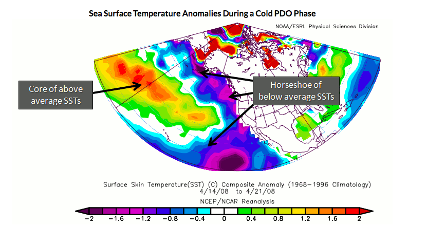
-
Tennessee Valley 2019 Fall Speculation/Forecasting
Carvers Gap replied to AMZ8990's topic in Tennessee Valley
Good info. I am not following that first PDO map, though - labels don't seem to fit or my mind might be missing the point....Anyway, -NAOs though usually signal very warm temps here during summer and early fall. No surprise there as that teleconnection has been accurate. As you noted the -NAO signal then converts to a cold signal during winter. Not sure when that -NAO finally begins to help us...but it has kept us abnormally warm for much of early fall. The cold off western SA definitely will be in play and may have consequences that equal the north PAC. It is a bit of a Nina signal, even though a Modoki is likely. That ENSO area has a tendency to signal a pretty good SER in early winter and then the SER collapses mid-winter. Will be interesting to see if any big storms or deteriorating typhoons impact that warm water in the GOA. That warm water will have a tendency to push AN heights into AK. That is where things get tricky. The past couple of winters have had the cold tuck almost underneath an Alaskan ridge. What is tricky is that if that kink in the jet (which is allowing for that cold under that high) resolves, the cold comes East. I tend to think this winter will feature more of a progressive pattern with cold building in the NW and then heading SE, sometimes severe in nature. Of note, I have seen several seasonal forecast predict a +NAO for this winter which would make since it has been negative for much of summer. So, I do agree that the Pacific will have to deliver cold as the Atlantic may be tough to convince. That said, seasonal weather models last winter were about as bad as I can remember. I still tend to believe that winter sets up shop in the Rockies for December and then spreads eastward during January and February. As PSU noted in the MA forum, tons of conflicting signals this winter and it is just tough to know which one. I agree that the oceans will likely drive it, but which signal....the Indian Ocean, the MJO, a falling or stalled QBO, PDO, warm ENSO in the mid-PAC, cold signal in the eastern PAC, a warm GOM, etc? Lastly, we are way overdue for a pattern change. This has been pretty much locked-in for nearly ten months. It can't stay there forever. But I guess it is always safer to bet the streak. I will comment a bit more on the Weeklies tomorrow. The do look colder for weeks 1-4ish. That said...shoulder it is season and the bust potential is always high. -
Tennessee Valley 2019 Fall Speculation/Forecasting
Carvers Gap replied to AMZ8990's topic in Tennessee Valley
I would not be shocked if this is the pattern for winter....cold builds over the Rockies and then rushes East with pockets of very warm air pushing up the east side of approaching fronts in between. Obviously, it will be less warm as the winter progress, just speaking of comparative norms. The seasonal models and even Weeklies bounce around from western trough to mid-continent trough for DJF. I think that might be because this winter could potentially feature a fairly progressive pattern where winter starts out West and builds eastward. I also realize that October is not a great indicator of winter. However, with the snowpack building over western Canada, at some point that cold air mass will move SE. Also agree that it is difficult to tell if this is a shake-up due to wavelengths or is an actual pattern change...but it is certainly different than the mega ridge. As a numbers game, I just think another big western winter is less likely, though I do think they get going strong in December....but the West has been due for big winters after the 90s which was a terrible decade in terms of water if I remember correctly. However, we are long overdue for a pattern change and wx models are notorious for perpetuating old patterns. No idea, but that is part of what makes weather a great hobby....And hey, the Vols even won! Might be that their play teleconnects well to the SER. Big SER beginning this weekend, and of course the Vols play at Alabama. Might be something to that.- 574 replies
-
- 1
-
-
- early winter
- leaves changing
- (and 3 more)
-
Tennessee Valley 2019 Fall Speculation/Forecasting
Carvers Gap replied to AMZ8990's topic in Tennessee Valley
As I dig a bit deeper(catching up after being out of pocket since Thursday PM)....modeling looks to have maintained a look where the SER only briefly bounces back next weekend and then it looks like maybe 1-2 pretty strong cold fronts move in later in the month into early October. No idea if true at this range. Modeling is yet again signaling a pretty significant pattern change. Does it hold or is it muted or even real? Time will tell. While the last "step down" was certainly muted, high temps are roughly 10-20 degrees cooler(depending on what days being compared) than even ten days ago. Temps are still AN, but tolerable to even pleasant. Looks to me like some true fall temps are going to show up during the coming 2-3 weeks. Easy prediction since it is fall...but given the past mega-ridge, I was beginning to wonder if fall would show. Interestingly, SE KY has a special weather statement posted for scattered frost tonight! It is important to note that some pretty warm air not unsurprisingly surges northward between cold fronts. I would not be surprised(as I noted in earlier posts) to see yet another record high or two posted. What I think might be interesting is that a record low might be approached as well due to the sharpness of the ridges being modeled on operational and ensembles. (That EPS ridge/trough look was not warm. ) I think it likely a lock that October finishes AN. Those first four days and the slow step down to tolerable temps thereafter(still well AN) pretty much assured that. Looks like TRI will have some highs in the 60s this week with even some low 60s possible. Within roughly 14 days of the mega ridge, that would mean that high temps have dropped by roughly 30 degrees. Again, I think we see a bounce back but not weeks-on-end of that heat ridge. While it was cold last evening while sitting outside, I think most(while cold) were thankful to see those mid90s temps gone.- 574 replies
-
- 1
-
-
- early winter
- leaves changing
- (and 3 more)
-
Tennessee Valley 2019 Fall Speculation/Forecasting
Carvers Gap replied to AMZ8990's topic in Tennessee Valley
The 18z GFS...Well. LOL. And, I thought I was cold with it being in the mid-50s last night! In all seriousness, I get a bit nervous when the GEFS and the EPS begin to get in lock step about potential cool downs - been some notorious misses recently. Sometimes it is a "to good to be true scenario." I am sort of in a "I have to see it to believe it" mode. However, if one were to take the 12z GEFS/EPS suites, that is not a warm look. That trend has been in place for a few days. So, one would expect operational models to now start spitting out some pretty wild looks from time to time reflecting what the ensembles are doing. I just want a day where we have highs in the 40s where I can tell my grandkids someday that...one time in October we set four straight record highs only to have highs in the 40s later that month. It was definitely surreal last evening as I was sitting outside in very light drizzle, a light breeze, and temps in the 50s in Johnson City. People, I forgot to bring a stinking coat or even a shirt with long sleeves!!!! All of these bands from all over the SE, which have been practicing in record heat, were almost certainly dealing with similar situations. Great and memorable evening for sure. -
Very possible. There were a lot of bands there...was a big BOA regional competition. I didn't get to see many bands perform as I help with getting stuff on and off the field...and on and off the semi. I usually only get to see another school's band right before our band goes on. I was able to see the finals presentation as we stopped to take a peak.
- 179 replies
-
- 1
-
-
- record heat
- transition
- (and 4 more)
-
Been outside working at a band competition. About. Froze. My. Tail. Off. Temps weren't super cold, but after mid-90s for temps, walking around in the 50s feels significantly cold. Really, that is a forty degree difference. Just not used to that weather yet.
- 179 replies
-
- 2
-
-
- record heat
- transition
- (and 4 more)
-
Tennessee Valley 2019 Fall Speculation/Forecasting
Carvers Gap replied to AMZ8990's topic in Tennessee Valley
The 12z EPS again looks nice with its evolution post d10 - if one likes fall weather. 18z GFS looks remarkably similar. Let's see if those looks get modified as we get closer as has been the recent pattern. For now, maybe some guarded hope that we might see some pretty chilly temps later this month(likely to see one more strong ridge embedded in the 16 day forecast range...but looks like it might be limited in duration.) Speaking of temps...I have West Yellowstone on my phone for wx. When I woke up, it was 2 degrees there. Record cold temps during this past night out West.- 574 replies
-
- 1
-
-
- early winter
- leaves changing
- (and 3 more)
-
The garden is doing well. You can compare to the first garden pic in the drought comparison. Three weeks ago the raised beds were pretty much void. Cool nights along with low humidity but warm days is like steroids right now for these crops. Cabbage, baby kale, baby mustard greens, strawberries(not producing, but to be totally expected during fall) and cover crop surrounding the raised beds are seen. Right behind the kale one can see the sprigs of some newly sprouted onions. One negative side effect to this heat...dang flea beetles are still alive and strong and got into my Swiss chard. All of that greenery is courtesy of the City of Kingsport water department.
- 179 replies
-
- 1
-
-
- record heat
- transition
- (and 4 more)
-
Will continue to compare MBY....lighting is different as well as the camera angle which makes it look a tad worse but to the exposure/brightness of the photo. However one can see the toll that the drought has taken during the last three weeks.
- 179 replies
-
- 1
-

-
- record heat
- transition
- (and 4 more)
-
During the pas 44 days, the closest weather station has recorded 0.09" of precip. That station is about 1.5 miles from MBY.
-
Tennessee Valley 2019 Fall Speculation/Forecasting
Carvers Gap replied to AMZ8990's topic in Tennessee Valley
If you can get hands on the overnight run of the EPS, give it a look d10-16 evolution is interesting for kicks and giggles - almost all of NA is cold at 850. Not sure I buy that, but that would be a trough that means business. Proceed at your own risk as this is the time of year(shoulder season) that it really flips around. We can at least enjoy it until the next run.- 574 replies
-
- 3
-
-
- early winter
- leaves changing
- (and 3 more)
-
Tennessee Valley 2019 Fall Speculation/Forecasting
Carvers Gap replied to AMZ8990's topic in Tennessee Valley
500 pattern on tonight's Weeklies looked acceptable. It runs almost all of the way through the end of November now but not quite. Pattern is a ridge in the East builds and is beaten down by a trough. Trough temporarily sets up shop in the East. Wash, rinse, repeat. No death permanent death ridge. 850 temps look reasonable. 2m temps again look exaggerated to the AN side. Nice to actually look at a set of maps that are not set on perpetual furnace mode with never-ending 500 mega-ridges. I think the forum has done a good job hashing out what is to come for the rest of the month. Those ideas look good. November is a question mark for me. I can definitely see both sides of the coin. With those heights over AK and the coastal West and heights in HB...have to think the pattern will likely be an elongated trough from the Northwest into the East of varying depths....Missoula to say Kansas City with it at times extending to Atlanta. Going to be a real fight between the SER and approaching cold fronts. Right now with summer time temps in the SE, the SER is formidable. As winter kicks in...the cold fronts will likely have more power to punch and hold. Keep the fires burning...I have been working as a volunteer in our local HS marching band this season. Weekends are gonna be busy for the month of October. Fridays are obviously HS games and Saturdays will be competitions. Huge amounts of respect for those young people as they have marched right through this record heat...tough hombres. Obviously, they are monitored closely with plenty of water breaks. Still..now you know why I have been interested in the heat. This week has been a welcome reprieve! You folks from the area know how hard they work. They pocketed their first ever national title in their division last year. Needless to say, they will get everyone's best this season during regional competitions. Regardless, they will take a trip to the Rose Bow Parade in January. Definitely going to be keeping an eye on the weather during the next three weekends, though this weekend is in a dome. Next two are outside. Probably will get you all to keep an eye on the weather in Pasadena when they head out there...- 574 replies
-
- 4
-
-
- early winter
- leaves changing
- (and 3 more)
-
Tennessee Valley 2019 Fall Speculation/Forecasting
Carvers Gap replied to AMZ8990's topic in Tennessee Valley
12z ensemble show a very back-and-forth pattern. Looks like a great week next week, then maybe a quick pop of the SER and another trough. MJO is helping us out - maybe. JMA was much different than CFS/Euro combo for weeks 3-4. Haven't done my usual browsing through today's wx data, but did get a quick look at the 12z suite. MRX has highs in the mid to upper 60s later next week for TRI - Jeff's fall weather which he discussed.. Right now we are running anywhere from 14-20 degrees below last week..and still somewhat AN. However, it feels great given where we were. Also, potentially some low 40s for lows at TRI next week. -
And the happy hour run of the 18z GFS did not disappoint. LOL. Brrrrrr. Low 40s into the Florida Panhandle.
-
That cold next to South America has SER written all over it. Worst case could be a torch...best case an inland storm track.
