

Carvers Gap
-
Posts
17,463 -
Joined
-
Last visited
Content Type
Profiles
Blogs
Forums
American Weather
Media Demo
Store
Gallery
Everything posted by Carvers Gap
-
Still having to dodge ice/snow when out running. Snow still on the north facing slopes of valleys. So, that is seven straight days with some snow on the ground here(some was still in the garden this morning).
-

January 2021 Medium/Longterm Pattern Discussion.
Carvers Gap replied to AMZ8990's topic in Tennessee Valley
Big thing, as Jeff noted a day or so a go(and I was privately skeptica but that was a good, little nugget!), is ridging is building back into AK. That is a much needed change. Additionally, there is a low over the Aleutians which is 100% the opposite of last year. If one was to draw-up a map for snow in this forum area, that is one of the looks. -
January 2021 Medium/Longterm Pattern Discussion.
Carvers Gap replied to AMZ8990's topic in Tennessee Valley
12z EPS looks really good. 12z CFSv2 also does. Very positive changes at high latitudes in regards to blocking(which was already good) -
January 2021 Medium/Longterm Pattern Discussion.
Carvers Gap replied to AMZ8990's topic in Tennessee Valley
Just forces everything underneath like we have had for the last month. Systems take the low road. The real question is whether we can get enough cold into the pattern. If we can get the cold, that would be a very wintery pattern. If not..cold rain and elevation snow. For now, I think we will see more events to track if the SSW works in our favor. I would actually be just fine with a PV that is knocked off center vs a total split. The only danger in this is that the trough dumps into the West and holds. That happened in 18-19 during that SSW, and also did that a couple of times during November without an SSW. -
January 2021 Medium/Longterm Pattern Discussion.
Carvers Gap replied to AMZ8990's topic in Tennessee Valley
Great look. -
January 2021 Medium/Longterm Pattern Discussion.
Carvers Gap replied to AMZ8990's topic in Tennessee Valley
If correct, that is an awesome winter pattern. -
January 2021 Medium/Longterm Pattern Discussion.
Carvers Gap replied to AMZ8990's topic in Tennessee Valley
That forecasted temp at hour 6 is 108 degrees colder than my forecast high of 45 today. -
January 2021 Medium/Longterm Pattern Discussion.
Carvers Gap replied to AMZ8990's topic in Tennessee Valley
Did some digging as well. This is from the Euro overnight. Sorry for the small thumbnail. Around hour 6, looks like eastern Russian is -52.9C which is about -63F. That is craziness. Looks like one, giant high pressure complex over Eastern Asia. -
January 2021 Medium/Longterm Pattern Discussion.
Carvers Gap replied to AMZ8990's topic in Tennessee Valley
I should add that breaks in continuity are not bad. Sometimes a model will break from the pack and be right, and sometimes it will be just be an outlier which doesn't verify. Right now, the EMON MJO is an outlier. However, how many times we have seen the Euro be an outlier only to win that battle? Once the SSW (will it split?) is felt, I have seen modeling flip on a dime. That can be good(Euro Weeklies yesterday, GEFS extended last night, 0z CFSv2 overnight) or bad (6z CFSv2 which is running now). Wouldn't panic with one CFSv2 run. Bounces around often during the same four runs of a single day. The real thing to watch is the BN heights that slide through the SW and into the East beginning around the 10th. If this goes the way of the Weeklies last night(and 0z EPS), that piece of energy should slide under the eastern ridge, form a trough in the East, pop a slight ridge around Southern California. The 6z CFSv2 does show how this could go wrong. Basically, the area of BN heights simply can't break through the eastern ridge, and the trough forms out West. There is precedent for troughs being forecast in the East only to end-up out West - happened twice during November already. I lean Euro right now. The only pause I have is that the GEFS/GFS has done pretty well with previous strat splits. However, it is January and the Euro is tough to beat once shoulder season is over. Pretty exciting times to be following the weather. Sure, there is possible dud option sitting on the table(that option is always there) and there is the potential for a really good winter pattern which is probably more likely than the dud. What will be exciting is some of the wild swings possible now on modeling. The close we get to this SSW, the more modeling will feel its influence. Sure seems like some things are breaking in our favor. However, we might not be completely certain of that until say Jan 3rd or 4th. -
January 2021 Medium/Longterm Pattern Discussion.
Carvers Gap replied to AMZ8990's topic in Tennessee Valley
What are the surface reports under that in terms of temps? -
January 2021 Medium/Longterm Pattern Discussion.
Carvers Gap replied to AMZ8990's topic in Tennessee Valley
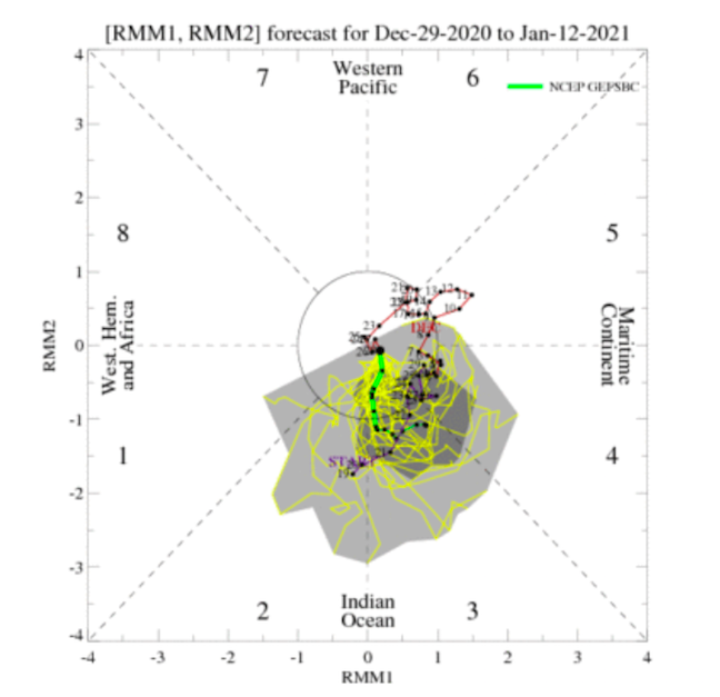
Two very distinct MJO camps right now. First one is the EMON which came out yesterday(Euro LR). That is a BIG break in continuity for it. This one is the NCEP GEFSBC from this morning. Pretty steady. Sorry for the different sized photos. Thought I had them resized similarly. Anyway, those two solutions would create basically two, entirely different patterns over North America. That is a massive break from continuity by the EMON.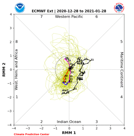
-
January 2021 Medium/Longterm Pattern Discussion.
Carvers Gap replied to AMZ8990's topic in Tennessee Valley
Good trends on today's GEFS extended as well. Similar look aa the Weeklies. Really hoping that modeling is feeling the disruption of the PV. -
January 2021 Medium/Longterm Pattern Discussion.
Carvers Gap replied to AMZ8990's topic in Tennessee Valley
If one looks at the last week of the 18z GEFS, it has remarkable agreement with the Euro Weeklies. -
Fall/Winter Banter - Football, Basketball, Snowball?
Carvers Gap replied to John1122's topic in Tennessee Valley
That is awesome. -
January 2021 Medium/Longterm Pattern Discussion.
Carvers Gap replied to AMZ8990's topic in Tennessee Valley
There are some nice weeks like BullCity posted. The thing I find encouraging is that the actual beginning of the pattern is on ensembles. Seems like the past few winters have featured Weeklies patterns which stayed 2-3 weeks out and never got closer. If I was looking for a problem, the only concern I would have is that some good looks in November dumped into the West after first being depicted for the East. The Weeklies seem to split the difference between the November and December pattern and also fits SSW climatology in terms of blocking as you and Holston have mentioned (Jeff as well). I don't like the MJO setup right now, but the SSW and -NAO could counterbalance that. Encouraging run for sure! -
January 2021 Medium/Longterm Pattern Discussion.
Carvers Gap replied to AMZ8990's topic in Tennessee Valley
Thanks, Holston. This is a 30 day 500mb map of the Euro Weeklies which runs from Jan 13th to February 12th. IF it is right, those anomalies might be stronger than that. Cold air would move south from Alaska into the Mountain West(front range) and then move eastward. My guess would be that Alaska is being fueled by cold from easter Siberia as evidenced by the 850 temps growing colder as the month goes on. There are some really good weeks buried in that 30 day map below. The blue arrow is obviously the path of cold air on the model. The red is either cold fronts dragging into the GOM and tapping the Gulf or systems moving along the Gulf phasing with strong cold fronts. Confluence would be over the East. As long as we can avoid the trough tucking into the West and holding(need a little help in the west with even the slightest ridge), and that keeps coming eastward. Pretty much the entire run from just after the 10th is this pattern. I would be happy with just three weeks of that! Huge grain of salt for all newcomers and tread lightly with LR maps. The great thing is that we are seeing this pattern evolution on the GFS(18z has it) and all global ensembles at 12z. Trough tucks into the SE, slight ridge pops out West, the pattern below commences.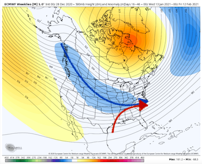
-
January 2021 Medium/Longterm Pattern Discussion.
Carvers Gap replied to AMZ8990's topic in Tennessee Valley
Oh yeah. It is a nice run. Hoping Holston posts a gif of the run. If not, I will post a screenshot of the 30 day 500 map - basically doesn't change so it would give everyone a good idea. He was bullish yesterday on the strat having a big impact. He got some serious backing today and really during the past 3 0z/12z suites. Looks like a really good call on his part. -
January 2021 Medium/Longterm Pattern Discussion.
Carvers Gap replied to AMZ8990's topic in Tennessee Valley
Webber is on fire today. LOL. -
January 2021 Medium/Longterm Pattern Discussion.
Carvers Gap replied to AMZ8990's topic in Tennessee Valley
@Holston_River_Rambler, have those Euro Weeklies ready to roll? You get the honors. -
January 2021 Medium/Longterm Pattern Discussion.
Carvers Gap replied to AMZ8990's topic in Tennessee Valley
Some of those patterns are not too far from where we are now, especially 09-10. Difference is the cold source. -
January 2021 Medium/Longterm Pattern Discussion.
Carvers Gap replied to AMZ8990's topic in Tennessee Valley
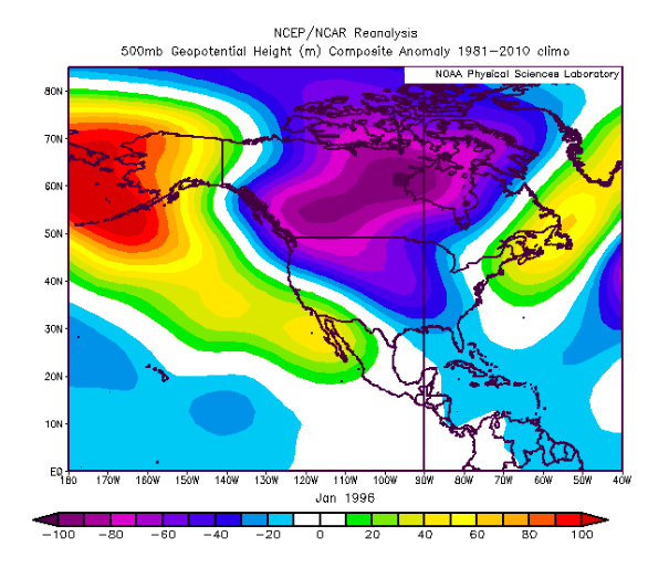
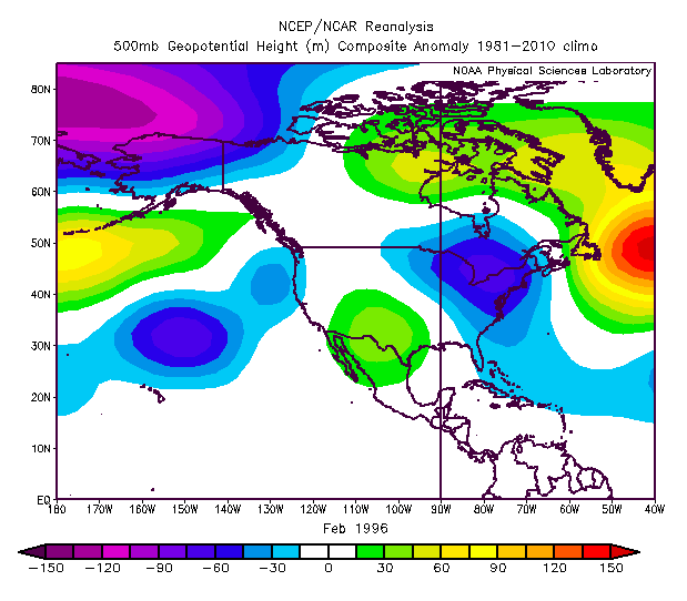
For fun...Here are some historically great 500mb patterns for the TN Valley forum area during winter.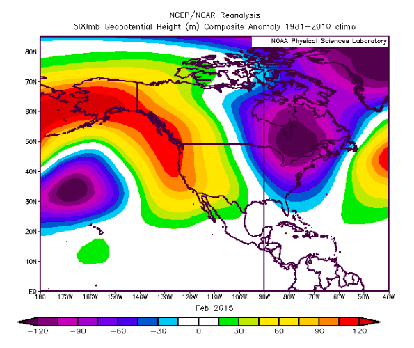
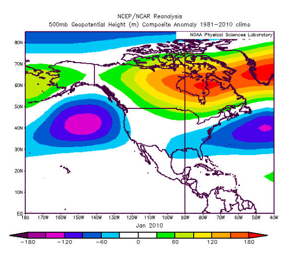
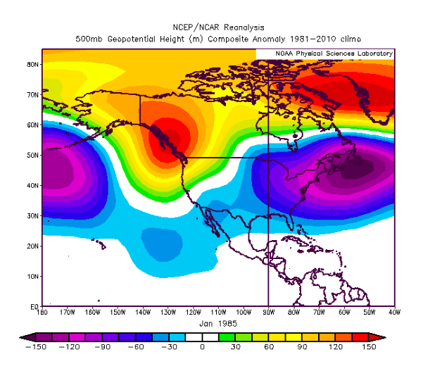
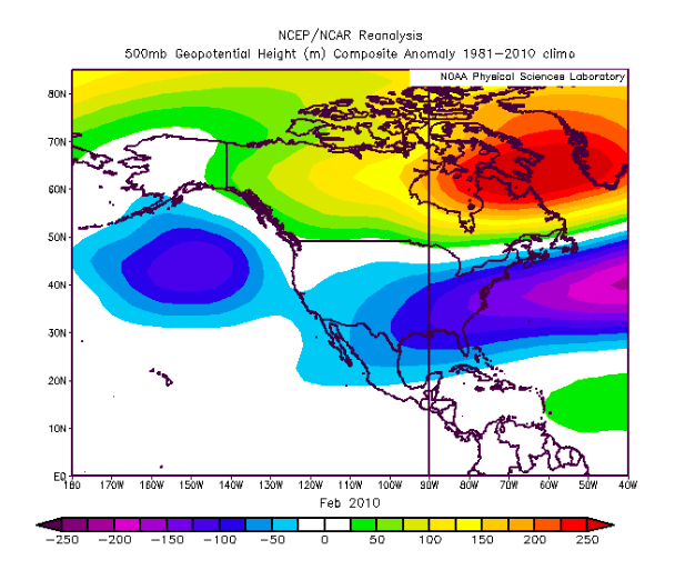
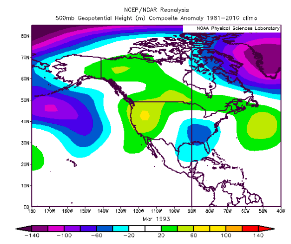
-
January 2021 Medium/Longterm Pattern Discussion.
Carvers Gap replied to AMZ8990's topic in Tennessee Valley
Looks like the d12+ GEFS, EPS, and GEPS now "splits" the western trough, and send part of it eastward. That is a good thing. The 12z EPS looks really good if one takes into account it is likely woefully undergoing the its trough(been a bias for months) underneath those blocks. The improvement since 12z yesterday is the eastern ridge appears temporary(at least for now - modeling is all over the place. I am a huge fan of the -NAO slows down flow and creates excellent confluence. Some great winters have had it. Some years with the Pac being the only dominant block, the flow is too fast. NW flow in Kingsport is also a non-starter as we don't get upslope stuff. A true -NAO (which is not battling the Pacific/MJO) is money during winter for east facing slopes. NE TN can get snow from an Atlantic fetch which is common during -NAO phase storms - TYS as well. The Christmas Eve Storm benefited from a PNA and the NAO both. Without the NAO, that storm likely cuts. Problem with the NAO right now...it is on its own and no cold source. If that NAO had Siberian cold to draw from...would be money - even if on its own. Our biggest problem regardless of the Pac or Atlantic blocking is that the cold is in Siberia. Saw Siberia nearly set an all-time record HP - think it was 1076 if the twee was correct. We need some of that here. I have my doubts that we get Canada seeded with cold anytime soon. Our cold will have to be homegrown. -
January 2021 Medium/Longterm Pattern Discussion.
Carvers Gap replied to AMZ8990's topic in Tennessee Valley
Para-GFS on Pivotal is pretty much there. -
January 2021 Medium/Longterm Pattern Discussion.
Carvers Gap replied to AMZ8990's topic in Tennessee Valley
They are feeling the disruption now for sure. If the SSW can simply jostle the TPV and keep it perturbed, that would be the best scenario(as long as it doesn't tighten up). Seeing some disruption to yesterday's second week of Jan modeling. Guessing the Euro is slow with that trough. GFS Para also has the Jan 3/4 storm. Just read a post by Cosgrove that said each trough is going to press the eastern ridge further east(once it forms) - meaning trough comes through, ridge resets a bit further eastward, wash-rinse-repeat until it slides OTS. Trends on modeling during the next couple of days should be interesting(could be good, could be bad). The CFSv2 seasonal is back to a trough in the East for January. -
January 2021 Medium/Longterm Pattern Discussion.
Carvers Gap replied to AMZ8990's topic in Tennessee Valley
And modeling is having a rough time in the short term. Check out this westward jog(forecast Trent) for the system that was forecast to snow for E TN at one point.


