

Carvers Gap
-
Posts
15,647 -
Joined
-
Last visited
Content Type
Profiles
Blogs
Forums
American Weather
Media Demo
Store
Gallery
Everything posted by Carvers Gap
-

December/January 2019/20 Winter Speculation Thread
Carvers Gap replied to AMZ8990's topic in Tennessee Valley
This is how bad the pattern is(if you like snow)...we are simply hoping that we can just get a cold/cool front or two to drive eastward and bring temps to at least seasonal for a couple of days at a time during the next 16 days. That should change, but the atmospheric pattern isn't driven by past climate data banks that say it should. I would not be surprised to see readings in the 70s in some forum locations during the next 7-10s day before we see some seasonal temps early in the New Year. I don't see many teleconnections or indices that hint at this pattern breaking, but pattern flips do occur...and the best we can do right now is to see if we can find when/if this occurs prior to spring. -
December/January 2019/20 Winter Speculation Thread
Carvers Gap replied to AMZ8990's topic in Tennessee Valley
Indeed, the overnight models are now depicting only a relaxation in the pattern that will be measured in days(maybe even 48-72 hours) centered around the NY with a very narrow potential for frozen precip. The EPS shows BN heights over Alaska that are locked into place during the d10-15 range. Looking forward to the Weeklies tonight to see if they flip back warm - I suspect they will. If not, they may well signal a way out of this mess. So really trying to see if they revert back to last Monday's look(likely trend I think) or double down on Thursday. If the Alaskan vortex moves into place, large chunks of January could potentially be warm...but, when it finally heads south(and it likely will) the flip will be impressive. That is brutally cold air. Bad thing? We may well have things in full bloom when it happens...IF modeling is correct about the warmth in the LR. Right now, I am riding with the EPs that shows periodic intrusions of seasonal cold in a base pattern that is above normal to much above normal for the next 3 weeks at least. Right now, the biggest feature change over the past 24 hours is the signal for a significant Southeast Ridge. That does not fit climatology, but the feature does teleconnect well to the Alaskan cold. So, instead of morning updates that are just repeating information about warm weather...going to hold off on my morning discussion unit the LR changes and we begin to get a consistent look again. Again, we have a small window for winter weather around the New Year. I do suspect this warm pattern breaks around mid-late January. Climatology supports this. However, in order to provide balance to those comments, know that some Nino winters during the late 90s featured very little cold(maybe one window during a couple of those winters) and very little snow at TRI. Warmth during Nino winters is nearly a given(excluding a few notable exceptions). Just going to have to ride this out. Hate to lose weeks during the heart of winter, but indeed, that looks like a real possibility. I suspect this head fake was a precursor to the pattern actually changing, but that could be 2-3 weeks into January, and I lean towards the longer time frame. As a reminder, I am only talking about temps. It CAN and DOES snow during warm, Nino patterns. That is why some actually like weak Nino patterns. -
December/January 2019/20 Winter Speculation Thread
Carvers Gap replied to AMZ8990's topic in Tennessee Valley
Impressive...and also a massive miscalculation by modeling that was depicting a -NAO for much of December at one time. If you see a sustained -NAO on global forecast models...beware. Likely not a run that will verify - a least not yet. -
December/January 2019/20 Winter Speculation Thread
Carvers Gap replied to AMZ8990's topic in Tennessee Valley
Going to go with a +NAO, active IO, un-cooperative MJO, a rising QBO, a developing drought, and a developing La Nina. Might throw in a extremely -EPO at times which produces record cold, collapses, then record warmth and rebuilds. Wash, rinse, repeat. Might even make a call for a BN December followed by AN Jan/Feb for that winter. Summer of 2021 should be an outright scorcher. -
December/January 2019/20 Winter Speculation Thread
Carvers Gap replied to AMZ8990's topic in Tennessee Valley
Looks like a very narrow window for snow in early Jan. The 18z GEFS, after multiple cold runs, has flipped seasonal to warm d10-15. i am still undecided for weeks 1.5-3. Lean warm to quite warm right now. But who knows. The MJO is gonna have to get out of 6 though... -
December/January 2019/20 Winter Speculation Thread
Carvers Gap replied to AMZ8990's topic in Tennessee Valley
I have sounded like a broken record for nearly three weeks. The LR trends are for a western trough with a brief relaxation around the New Year. The stage is set for a very warm overnight run of the EPS. Its LR usually takes about two runs to really flip. A cold Alaska is a teleconnection for a very strong SE ridge. The MJO is now forecast to loop back into phase 6 on the American suite which is usually cold - not good. The MJO on the European sweet is COD or low amplitude warm phases. Right now, I have low confidence that yesterday's 12z cold ensembles are correct. Looks more and more like a brief relaxation and then a return to a warm or even very warm pattern. It is possible and even likely that wx models jumped the gun(or the shark) yesterday. Again, this current pattern began around December 8th. Have to add nearly 35-42 days to that date before we see the pattern break down. I think what we are likely seeing on modeling are some early signals that the pattern is about to break down, but not there yet - or anywhere close as a +AO, +NAO, and +PNA are showing up in modeling. Tough to get any sustained cold from that. Yesterday, it appears was indeed a wicked head fake. We need the EPS to break back as it is absolutely schooling the GEFS and GEPS right now in the LR. It wasn't a few weeks ago, but the GEFS is now playing catch-up and is about 24-36 hours behind the EPS. -
December/January 2019/20 Winter Speculation Thread
Carvers Gap replied to AMZ8990's topic in Tennessee Valley
Looking for some run-to-run continuity....not there yet. Yesterday's 12z model suite was about as cold as I have seen it from a 500 persepective. And yet again, the overnight EPS went warmer - would still be decent cold for winter but not the extreme 500 look. I have a realistic theory as to why this happens - no conspiracy stuff. Think about when the sun hits the areas of the MJO and fires the convection there and think about when Siberia is coldest. I suspect(though far from certain) that data gets dumped into modeling overnight. Then, as the MJO region and Indian Ocean regions cool due to overnight temps...the MJO looks slightly different at 12z due to less intense convection. Also, those frigid overnight low temps from Siberia begin to get inputed. It is uncanny to see the overnight suite continually reverse course from the 12z suite or mute trends. So, in theory, makes me wonder if daytime convection on the other side of the planet is fouling the MJO and thus inputing a different MJO than its opposite run. When I say the MJO is bouncing around, it is bouncing wildly. I do lean cold for the second week of January...but as I noted yesterday, the past two runs of the Euro Weeklies are very realistic and very different for our region. The current pattern could go either direction: 1. Trough lifts out of the West and gives us a brief but intense cool down and then re-establishes out West 2. The trough could roll eastward and lock into the East. When one looks at the EPS, it really looks like it is stuck in between those two solutions. You can kind of see how the full latitude trough is colder on one side of NA than the other at the same time frame and then flip-flops. Looks to me like it hasn't quite worked that out yet. I think the full latitude trough solution is actually in error(might be correct for a few days). I think the full latitude trough solution is the EPS actually having two different tough placements on the same ensemble map. So, I definitely advise caution in the LR. While yesterday was awesome and I admit that I was excited...the morning's 6z GEFS and 0z EPS return us to their usual uncertainty. -
December/January 2019/20 Winter Speculation Thread
Carvers Gap replied to AMZ8990's topic in Tennessee Valley
Talk about some cold ensemble runs today. Wow. That EPO ridge in conjunction with a mid-Atlantic ridge will create a block that could potentially discharge very cold air into much of the United States and Canada. I definitely want to see some run-to-run continuity before really jumping on the cold train. The MJO gives me some pause. But make not mistake, if those ensembles(EPS and GEFS at 12z) verify, that would create a highway for cold air to reach clear to the GOM. -
December/January 2019/20 Winter Speculation Thread
Carvers Gap replied to AMZ8990's topic in Tennessee Valley
That is a BIG drop of the SOI. And the 12z EPS. That is an incredibly cold look during the d10-15. -
December/January 2019/20 Winter Speculation Thread
Carvers Gap replied to AMZ8990's topic in Tennessee Valley
Indeed, the MJO this morning progresses into 7 and loops back into 6 which explains some of what we are seeing on modeling this morning in terms of a step back. My guess is that (if it does that), it will eventually loop back or not happen at all. But one can see why modeling is flip-flopping. Yesterday's MJO was nearly textbook for cold...overnight, not so much. -
December/January 2019/20 Winter Speculation Thread
Carvers Gap replied to AMZ8990's topic in Tennessee Valley
The weather pattern that many are focusing on is about ten days out, maybe nine now. The Euro OP was likely heading to an eastern trough late in its run. The 6z GEFS is definitely there. I wasn't a huge fan of the EPS overnight as I thought it took a step back. The Weeklies two runs ago(on Monday) pushed a temporary trough eastward in early January, and then pulled it back West for most of January. OTH the Weeklies on Thursday, pulled it back and then eventually would send multiple shots of progressively seasonal to cold air eastward - looked like November. The 12z EPS yesterday looked firmly in the camp of Thursday's run. The 0z overnight still looked like Thursday's run, but slower...almost to the point it looks similar to Monday's bearish run. The models showing something good and then pulling it back has been happening for about a month. If one just splits the difference, like means we are dealing with some above normal heights over the coastal SE for a time(likely won't stay there as El Nino climatology really won't want it there). Bottom line: Proceed with caution, but also know we are approaching the time when modeling potentially could begin showing signs of a flip. We have been AN since roughly the beginning of the second week of December. Patterns usually(barring last winter's catastrophe...LOL) run about 4-6 weeks. So, I could see a couple of realistic scenarios. The warm pattern (that we have been in for a couple of weeks already) ends prematurely around January 1 OR the pattern relaxes around January 1 only to flip a couple of weeks later in mid-January. December 7 to Jan 15 is about 39 day(almost six weeks). It is very possible the models are jumping the gun, will pull back, and eventually buy in. Remember how the warm-up was modeled? Sort of went like this during several model suites in succession: warm, cold, warm, warm, cold, warm, warm, warm....and the warm pattern kept getting pushed back and eventually arrived during the second week of December. I would not be surprised if we see that same progression as we turn much colder. The real fly in the ointment is if the TPV just sits up around the North Pole and tightens up. They are due a cold winter at that very high latitude. So there is that. Will be interesting to follow the MJO saga this morning. Back to loading...keep the fires burning! -
December/January 2019/20 Winter Speculation Thread
Carvers Gap replied to AMZ8990's topic in Tennessee Valley
If you all don't care...I say let's have @AMZ8990 rename this thread to December and January Speculation Thread if that is cool. I think most of the discussion will focus on late December and early January from here on out. Lots of great discussion. I am pretty much too tired to type a much else. Great model trends during the past two days. And to be clear, this is not a model flip IMHO. This is just the potential pattern after the warm-up. -
December/January 2019/20 Winter Speculation Thread
Carvers Gap replied to AMZ8990's topic in Tennessee Valley
There have been several MJO forecasts already this season that have wanted to take it into the warm phases...and it doesn't verify there. Interesting conversation about the potential issues with the MJO interference and forecast issues. And I do think the global models do take into account the MJO itself which might be why we have seen so much variation in their potential outcomes. I have simply resorted to looking at the satellite for the Indian Ocean and MC regions. -
December/January 2019/20 Winter Speculation Thread
Carvers Gap replied to AMZ8990's topic in Tennessee Valley
Good trends for the past day for sure! -
December/January 2019/20 Winter Speculation Thread
Carvers Gap replied to AMZ8990's topic in Tennessee Valley
@TellicoWx, you need to post more. LOL. That is some good stuff on the QBO, MJO,...stuff. You are bringing it this morning. You too, Holston. -
December/January 2019/20 Winter Speculation Thread
Carvers Gap replied to AMZ8990's topic in Tennessee Valley
Descending simply means moving down to lower altitudes. Check. So, looks like a preponderance of high altitude winds in that area of the world have switched to the east. Looks like it has almost flipped at 30 which has decent correlation to high latitude blocking of which were are seeing some signs now in the longer range. Last year, the positive QBO(westerly) was taking over and I think that had something to do with our warm second half of winter(that and the SSW that dumped West). As Jeff has noted, the actually movement of the index is likely the trigger vs the actually raw negative or positive number....though, it going negative is not going to hurt. There is also some research that indicates that solar cycle state also influences the QBO. In other words, it behaves differently(quite differently) during maxs and mins which is why sometimes the QBO doesn't line up cleanly with surface weather. But in general, very good sign. -
December/January 2019/20 Winter Speculation Thread
Carvers Gap replied to AMZ8990's topic in Tennessee Valley
Very good trends on overnight modeling...As John noted, the EPS has cold in here by the New Year. The ridge begins to erode on December 28 around hour 204 with a full latitude trough in place by 300+. Let's see if the full latitude trough idea is just the ensemble trying to figure out which area of NA to put the trough - meaning some members may be west and some east, thus creating the false appearance of a full latitude trough. That could mean a continuation of the trough out West, trough east , or the rare feature which is the full latitude trough. Light years better than 48 hours ago. It is not so much that the model has flipped. It has not. It is simply that we are are now far enough along to see the end of the pattern. It also might be a hair quicker. The Weeklies give me greater confidence that we indeed have a shot at getting out of this. A word of caution, sometimes models will hurry a pattern and we don't know if this is just a relaxation of the current warmish pattern. That said, the change would be very representative of several Nino analogs including the 14-15 analog that someone mentioned in the thread(Tellico or Holston or Boone?). Additionally, we need to keep an eye on the MJO as it was not favorable yesterday. Would be pretty rare to get a cold snap with it stalled in phase 6 or 7... Also, unless I am reading this incorrectly, looks like the QBO is almost(edit...evidently I can't read a graph) negative at 30. It is also common for 30 to flip prior to 50. Let's get that MJO headed in the right direction so we don't get a head fake with this look. Will look at it later. Note: That said, this site lists the QBO as negative(easterly). Looks to me like that is positive at 30. Any ideas on why that is? I mean that is awesome if it is already negative, but that is now how I read it at 30. https://acd-ext.gsfc.nasa.gov/Data_services/met/qbo/qbo.html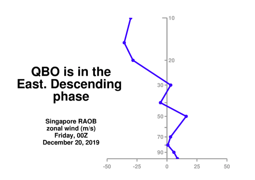
-
December/January 2019/20 Winter Speculation Thread
Carvers Gap replied to AMZ8990's topic in Tennessee Valley
The Weeklies feature a fairly significant break in continuity and one that actually connects well to the afternoon Euro run(Weeklies are derived from the morning run). Last year, the Weeklies rarely matched what was actually on the EPS. These match. Let's see if this break in continuity actually holds. Been far too many false starts this winter for me to buy in just yet...but that pattern on the 12z EPS and the Weeklies is probably better than just a "good pattern." Would like to be able to say, "That is the break we have been looking for...." Not ready to say that yet, but that those two model runs have "winter" written all over them. Indeed, they look like....November. Now, if we can just get the atmospheric river event out of the way before the Rose Bowl Parade is held! -
December/January 2019/20 Winter Speculation Thread
Carvers Gap replied to AMZ8990's topic in Tennessee Valley
Euro Weeklies looked good...entire run. Big grain of salt... Looks like the pattern is cold into the northern Rockies that kicks eastward. -
December/January 2019/20 Winter Speculation Thread
Carvers Gap replied to AMZ8990's topic in Tennessee Valley
I don't see anything on the 12z GEFS run that inclines me to think any cold outbreaks are headed our way for quite some time. My week two cool-off is severely in doubt. Warm run. edit: Not even one cold front makes this way after hour 54. -
December/January 2019/20 Winter Speculation Thread
Carvers Gap replied to AMZ8990's topic in Tennessee Valley
I do think we get a transient shot of cold air during the second week of January...that will be a window to watch as the STJ has not relaxed a bit. There are sort of two camps regarding good snow patterns.... 1. Those who want plenty of cold air in repetitive shots... 2. Those who want an active precip pattern... I don't think the first choice is going to be an option for some time. But that second choice is probably going to be in place for some time. Any cold shot from here on out probably is going to have winter tracking with it. Those cold shots are likely very transient. However, it won't take much cold with an active STJ for things to get interesting. IMHO, we could see some snow chances in January despite AN temps. Just need one or two cold shots, even if just 3-4 days at a time. I think February will be a good month. Tellico has a good analog to support that. And the current pattern should have run its course by then provide we don't get some SSW that dumps into the West like last year. You all keep the fires burning for the next couple of days...going to be helping with loading the band's equipment for the Rose Bowl Parade. Shipping 300+ instruments and all of their gear cross country is like moving a house! -
December/January 2019/20 Winter Speculation Thread
Carvers Gap replied to AMZ8990's topic in Tennessee Valley
Good post. I think that year is an excellent analog...a lot of similarities in both timing and how the actual pattern evolved. The QBO should be working for us very soon as well. I would not be surprised in the least to see a similar evolution with this year's pattern. I think if/when the pattern flips...it will be a pretty stunning reversal. Last year, obviously that did not happen but the atmosphere was dealing with a La Nina hangover. I said it last winter and I will say it now...this is exactly why I don't like El Nino winters. Just takes forever until we actually get to prime months. Then, if things don't work out...kick in the pants for sure. Pretty much during El Nino winters, we head into the bottom of the ninth down 3 with the bases loaded w/ the heart of our line-up on deck. No guarantee of a win, but you have had to sit through the entire game just to get to the best part - and it still might not work out. -
December/January 2019/20 Winter Speculation Thread
Carvers Gap replied to AMZ8990's topic in Tennessee Valley
Man, I hate brining the heat...LOL. Yes, agree we likely flip cold at some point, and I wouldn't be surprised to see a substantial flip. Not seeing the flip yet...but 14-15 saw a super warm December I think that eventually flipped cold. The Indian Ocean deal is probably my biggest concern regarding any flip, but Nino climatology supports a cold second half of winter. That said, last winter's scars make me less confident. LOL. I feel like we looked for a flip that never came. I do think this winter will be different. While repeating weather patterns are not an uncommon phenomena...they do end. And I shouldn't be surprised at the warm December after mentioning it months ago...just not any fun talking about it. Hopefully, the rest of that forecast from June will come to pass with a cold second half of winter. Again, I am actually not that discouraged with the past two runs of the EPS. -
December/January 2019/20 Winter Speculation Thread
Carvers Gap replied to AMZ8990's topic in Tennessee Valley
It is official. The GEFS has caved 100% to the Euro in the LR. I will be interested to see where the Euro Weeklies go with the pattern tonight, not so much after week four, but where it would take the pattern week 3 and 4. They were workable on Monday. What the "cave" by the GEFS means?...the EPS is likely hitting form as it has been locked onto this pattern for a couple of weeks. Also, when I talk great winters...I mean great snowstorms. Many of those are found between mid-Jan to mid-Feb. I think at this point, there is nothing we can do. We will just try to sort out when/if this pattern is going to change before winter is over. Hoping for a flip. That is not very scientific, but is about all we have at this point. -
December/January 2019/20 Winter Speculation Thread
Carvers Gap replied to AMZ8990's topic in Tennessee Valley
Convection is found across the entire Indian Ocean basin as of mid-day.


