

Carvers Gap
-
Posts
15,647 -
Joined
-
Last visited
Content Type
Profiles
Blogs
Forums
American Weather
Media Demo
Store
Gallery
Everything posted by Carvers Gap
-

December/January 2019/20 Winter Speculation Thread
Carvers Gap replied to AMZ8990's topic in Tennessee Valley
12z Euro lived up to its nickname of Dr No. -
December/January 2019/20 Winter Speculation Thread
Carvers Gap replied to AMZ8990's topic in Tennessee Valley
I think when we look back, the abnormally high IOD is going to have been a major player in this warm month. Now frd in the MA forum has an updated report on the quickly falling index. Question is...how much lag time does that index have before its effects hit modeling? No idea. -
December/January 2019/20 Winter Speculation Thread
Carvers Gap replied to AMZ8990's topic in Tennessee Valley
And one takes into account that it likes to over-amp things....definitely a window to watch and maybe for the next couple of days after that even. You upslope folks might do well in its wake. I don't think the GLs are frozen over yet. -
December/January 2019/20 Winter Speculation Thread
Carvers Gap replied to AMZ8990's topic in Tennessee Valley
12z GFS basically had it, but its progressive bias might have washed it out. And right there is how it can snow during a warm pattern and why there is a camp 2 regarding winter weather. Some years, we can't buy a storm...others we seem to hit even during warm patterns. I have mixed emotions on this one with family traveling back from Pasadena during the early January winter wx window. What you all need me to do is buy a ticket to the Rose Bowl Parade and that will guarantee a HECS! -
December/January 2019/20 Winter Speculation Thread
Carvers Gap replied to AMZ8990's topic in Tennessee Valley
Good find. Definitely a window around that time frame... -
December/January 2019/20 Winter Speculation Thread
Carvers Gap replied to AMZ8990's topic in Tennessee Valley
FRD has some going IOD stuff in the MA forum. It is falling which we new, but had huge values during early winter. Here is one thing that I notice in recent modeling...the ensembles seem agree too much with the actual operational. That characteristic alone is making it difficult to cull out bad operational model runs. Ideally, the ensemble should not bounce around like the operational. The GEFS is all over the place. One run it will look poised to release bitterly cold air...next it is an entirely warm NA continent. Let's see if we can get something to buy into the 12z GFS/GEFS suite. So far, no takers. -
December/January 2019/20 Winter Speculation Thread
Carvers Gap replied to AMZ8990's topic in Tennessee Valley
12 GFS definitely continues its trend of being cold(er). Is it right? The CMC will have none of it and is very warm. It has been an outlier in the LR for about a month - wicked cold bias. That said, it did spot the November cold flip well before any other model. Problem is that it does not fit its recent MJO trend. It is going to need some support in the medium and LR before I give it any weight. So, is it still crying wolf or is it on to something? Hoping for a Christmas miracle over the next 36 hours! -
December/January 2019/20 Winter Speculation Thread
Carvers Gap replied to AMZ8990's topic in Tennessee Valley
Yeah, snow is a weird deal at this latitude. Doesn't take much to get us to normal. I am sure big coastals have a large say in TRI's snow averages, and it only takes one of those. I got 12" of snow at my house last year during early December. That was pretty much it, but that got me pretty close to a normal winter with one storm. My bushes still look terrible almost twelve months later. LOL. And temps finished well AN with near normal snowfall. If the MJO rolls into 5/6, the blue monstrosity is going to start taking a beating. What would be wild is for that super charged, cold air mass to get dislodged(the QBO and MJO argue for that...just no evidence of that yet). Not sure it is likely, but it is not out of the realm of possibility that the entire thing could get sent to lower latitudes. Wherever it goes, it is going to break some record lows. Fall pattern was very warm, and then took about 2-3 weeks to move to a very cold pattern in November. Something similar would not surprise me in the least. I just don't like near record warm temps in the heart of winter. -
December/January 2019/20 Winter Speculation Thread
Carvers Gap replied to AMZ8990's topic in Tennessee Valley
I stated this yesterday and it somewhat bears repeating. The reason folks like weak Nino patterns is that there is quite of bit of energy in they system. It is one of those types of wx patterns where it can and does snow during an otherwise warm pattern. Something I also noted is that there are two(chicken and egg) camps regarding potential for winter wx. Camp 1. Cold weather needs to be in place. Camp 2. Needs to be plenty of moisture in place. Two of the biggest snows that I have seen were during very warm but active patterns. It was a shutout otherwise. Jury is still out for late January and February. Could stay warm(sort of has that feel right now...but that is not scientific) or could flip on a dime. I don't think many were expecting(I wasn't) a PV to set-up shop over Alaska - that is going to create havoc with predicted seasonal timelines. And again, the Alaska deal can release piece of the PV southeastward. We have seen that from time to time on the cold prone GFS. -
December/January 2019/20 Winter Speculation Thread
Carvers Gap replied to AMZ8990's topic in Tennessee Valley
Order of importance right now IMHO...When in doubt, look to the oceans... 1. Indian Ocean convection - abnormally positive IOD in early winter. https://www.esrl.noaa.gov/psd/gcos_wgsp/Timeseries/Data/dmi.long.data 1. MJO is easy pick for me. Lots of convection where we don't want it, even if low amplitude. Correlates very well, even at very low amplitude(even in the COD), with the warm weather we have had this month. It is also the reason that I have been banging the drum for this warm-up. 2. The unusual ENSO state with cold water neat South America, warm in the western Pacific. 3. Warm water in the GOA. 4. Tightening PV over AK which I think is a 2 week phenomenon there. 5. Recent seasonal trends during the past decade which feature warmer falls and cooler springs. Weaker signals. 1. SOI 2. QBO Wild cards: Solar and sea ice. Also, it is important to note that several Nino winters(some admittedly super) were very warm during the 90s. Again, patterns can and do flip on a dime. I don't see a ton of that(edit: meaning sustained cold) during the next two to three(edit) weeks. -
December/January 2019/20 Winter Speculation Thread
Carvers Gap replied to AMZ8990's topic in Tennessee Valley
Been a great Christmas Eve discussion. I have to go get a run in and then do some Christmas stuff. Heres to a better looking MJO and model suite over the next few days! Merry Christmas, everyone!!! I will try to check back. -
December/January 2019/20 Winter Speculation Thread
Carvers Gap replied to AMZ8990's topic in Tennessee Valley
MJO forecasts have updated on CPC...The CFS forecast above would be likely be a cold signal. It has changed from yesterday as it no longer goes completely through the cold phases and has dropped into the COD after a few days in phase 8. It is the only model that I can find with decent MJO phases, but is trending away from that. The Euro depiction takes the MJO into phase 5 and then basically stalls there. Looks like what the CFS is trending towards that. The GFS/GEFS matches the Euro. I can't stress this enough...we need that to change soon as that is generally a prolonged warm signal for eastern NA. Now, the MJO has done multiple head fakes into those regions for the past couple of months and it has not made it there. As noted above, the weakening of convection in phases 1/and 2 is likely allowing for the MJO to loop back into phases 5 and 6. Will it get there and how long will it stay if it does? Climatology/ENSO state argue strongly against this, but there it is on modeling nonetheless. Let's see where modeling goes today and tomorrow... Might be pay me now or pay me later type deal though. If 6 warms, it could eventually break loose a very cold PV and force it to lower latitudes. It would occur during late winter though. -
December/January 2019/20 Winter Speculation Thread
Carvers Gap replied to AMZ8990's topic in Tennessee Valley
Jax, when you say destructive....is that referencing the NA pattern and eastern warmth or is that referencing the dual phase (both 1/2 and 6) being depicted by IR satellite images? -
December/January 2019/20 Winter Speculation Thread
Carvers Gap replied to AMZ8990's topic in Tennessee Valley
Ten million dollar question right there...When modeling flips around, I suspect the forecast for those ares is driving the flip. If we are going to see any type of decent winter, the convection just west of the dateline has to subside. Might be that the weird ENSO set-up is wrecking havoc on things. Warm west Pacific and cool eastern. It is even possible that the ongoing QBO reversal has something to do with this as well. The QBO is correlated with PV disruptions. That phase 6 of the MJO I think is also correlated with PV disruptions. The PV is definitely not disrupted right now and is the opposite of that. However, will be interesting to see what all of that heat/steam being pumped into the atmosphere does to it. Lastly, the model that actually has a phase 6 looks is the EPS. The GEFS not as much. After looking pretty closely at the MJO, looks to me like the EPS by far has the more accurate depiction of the NA wx pattern. -
December/January 2019/20 Winter Speculation Thread
Carvers Gap replied to AMZ8990's topic in Tennessee Valley
One can see why the MJO is a pain to forecast right now...The western Indian Ocean convection does not teleconnect to the convection just west of the dateline. So, the MJO values are bouncing all over the place. For those that are not sure what they are looking at...the green on the graphic above is in the western Indian Ocean for phases 1 and 2 which indicates rising air. The region near the equatorial dateline is brown which signifies sinking air. But right now, we have rising air in both the dateline and western Indian Ocean regions. -
December/January 2019/20 Winter Speculation Thread
Carvers Gap replied to AMZ8990's topic in Tennessee Valley
Here is a screenshot from the CPC site (https://www.cpc.ncep.noaa.gov/products/precip/CWlink/MJO/mjoupdate.pdf). Looks convection near the dateline is a phase 6 on this graphic and on current satellites. -
December/January 2019/20 Winter Speculation Thread
Carvers Gap replied to AMZ8990's topic in Tennessee Valley
Most years, yes. However, his daily stuff is usually pretty good. I know a bunch of folks don't like him, but I like they guy. His seasonal forecasts have not been great, and one could make a case that is to drive clicks. That said, seasonal forecasting is a total crapshoot for pretty much anyone. For example, I bet very few foresaw the PV tightening up over Alaska. His mistake this year was cooling his December forecast at the last minute which was warm. January will likely be warm due to some really warm days during the first ten days of the month - would take some serious cold to reverse that. Was going to post this anyway(not a response to weathertree) so will post it here. The QBO was negative yesterday. That is significant in that it "might" mean that the PV is going to see some disruption. Now, the value itself is not significantly negative by the trajectory seems like it is. I am not sure what kind of lag there is regarding the negative value and PV disruption. It is a "newer" index in terms of forecasting use, and we don't understand it as well as we need to. When strongly negative, it has a tendency to correlate to PV displacement and high latitude blocking. Not strongly negative yet, but something to watch. I suspect it is not a driver at this point so it likely would have to act in concert with other drivers of which not many point to cold. That said, if the MJO were to finally sneak over and hold in the negative phases...then, the -QBO(as long as it doesn't stall...been hovering at this value for a few days)might actually have an enhanced effect on blocking. So, if we are looking for positives(and they are few), there are a couple of big hitters that are in our favor: deeply negative SOI along with a sharp drop yesterday and the QBO being negative at both 50mb and 30mb. The SOI can sometimes foreshadow flips on modeling with big drops. The MJO provides a counter to any flip.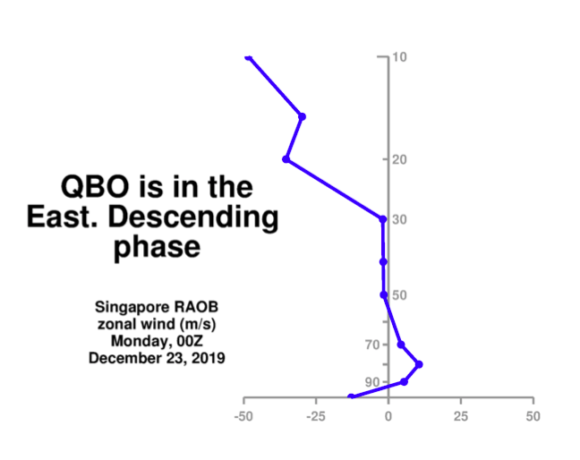
-
December/January 2019/20 Winter Speculation Thread
Carvers Gap replied to AMZ8990's topic in Tennessee Valley
Just watched JB's video today. He is pretty distraught. His winter forecast is about to go up in smoke again if models are correct. Now, here is an interesting nugget. The convection over the western Pacific is very much phase 6 of the MJO. However, the convection over the western Indian Ocean correlates to phases 1 and 2 which are winter/cold phases. If the western Indian Ocean convection collapses, then the phase 6 look becomes the dominant phase in the long run. -
December/January 2019/20 Winter Speculation Thread
Carvers Gap replied to AMZ8990's topic in Tennessee Valley
I should note that the MJO does go through 7 prior to looping back which does fit its cool down around the New Year. If we wanted to see a flip...it would never loop back and be a false loop. -
December/January 2019/20 Winter Speculation Thread
Carvers Gap replied to AMZ8990's topic in Tennessee Valley
Also, the MJO this AM(RMM1/RMM2) heads back for phase 5. Not a good look, but the other models have not updated on the CPC site. And a glimmer of hope, the SOI has fallen to ~ -21. Big drop. -
December/January 2019/20 Winter Speculation Thread
Carvers Gap replied to AMZ8990's topic in Tennessee Valley
0z EPS has reverted to the PV being over AK. I could find only one cold front that made it through at 850, and it is around NY. Its trough configuration is improving slightly relative to the shut out pattern that had been shown. 6z GEFS has a +AO, +NAO, -PNA, and +EPO(might be slight debate on that one due to the eastern PAC location). PV looks really wrapped up tight. Of note, the GEFS until recently has been perpetually cold in the d10-15 for most of December...TRI will finish much above normal once this week is done. The GFS operational did sniff out the pattern change in November about 2-3 days prior to the Euro. Back then though, the Euro couldn’t catch up. Now, seems like the GFS is struggling. If we are going to flip mid-month we will likely see an oddball run now and again on operational modeling. Would be awesome to see modeling flip on Christmas Eve or Christmas Day. Biggest problems(and they are big) this AM are a very wrapped up PV and teleconnections opposite of the values that we need. The GFS has shown some cracks in the armor as John has noted. Let’s see if the dam will break. The 6z GFS showed a piece of the PV break off and head SE. Thst is a legit way to scrounge up some decent winter wx if the PV stays locked over Alaska, but releases cold from time to time. Need the EPS to crack or show some signs of doing so. -
December/January 2019/20 Winter Speculation Thread
Carvers Gap replied to AMZ8990's topic in Tennessee Valley
Now, I do post the above model snapshot for a reason...systems that dig that far into the GOM have to be watched - even during a warm pattern. It is a good example of how things can amplify with good timing. Do I think Jacksonville and Savannah get a blizzard? No. And if it does, just time to hang it up this winter!!!! But in the middle of all of this warm talk...pretty hilarious run! So the Vols wanted to go to Florida for a warm football game? -
December/January 2019/20 Winter Speculation Thread
Carvers Gap replied to AMZ8990's topic in Tennessee Valley
This is when you know the GFS has bought a one-way ticket to crazy town. Don't see this every day on modeling. -
December/January 2019/20 Winter Speculation Thread
Carvers Gap replied to AMZ8990's topic in Tennessee Valley
This will be my last weeklies update until(if) things change on that model. Indeed, the Weeklies reverted back to a western trough much like they did last Monday. They have a perpetual SER, sometimes weak and sometimes very strong, through the run after the second week in January. Looked very much like September and October - but less extreme(unless the extreme is simply being washed out). At this point, if the Weeklies are right(HUGE if)...the pattern we are seeing is the winter pattern. Really nothing more to say or belabor the point. When I am having to look at d14 on a model for any signs of change...we are in a very warm time frame. It can still snow in a warm pattern. We saw that during the 90s from time to time. At this point(and that could easily change), I see no signs of a flip to sustained cold. We do have a wintery window around the New Year, and then it warms. As for the PV, the Hudson Bay is sort of the lesser of two evils. Having the PV over NAO territory is only slightly better for us than having it over Alaska. If one is looking at higher latitudes, it is blue where it should be yellow and yellow where it should be blue. I no longer am calling for a flip to a cooler pattern. There is no evidence of that on modeling. Climatology says it is possible and maybe even probable. That is our hope. However, there are Ninos during the 90s where the pattern never turned cold for sustained time. I do suspect a flip will come...just not seeing it anywhere on modeling at all today. Other than about 72 hours of cold...it is a base above normal pattern on multiple models. The other rule of thumb that supports a flip is that the pattern should change after 4-6 weeks which is around or just after mid-January. I doubt the Weeklies are correct after week 4 as they are usually just a continuation of their derived run. However, many other models depict little sustained cold in the SE. So, tough to toss the Weeklies at this point. -
December/January 2019/20 Winter Speculation Thread
Carvers Gap replied to AMZ8990's topic in Tennessee Valley
If we wanted to go old school....we could just root for pieces of the AK vortex to break off and head SE every few days. The GFS at 6z and 12z has this, but again, not going to find myself in a foxhole with that model. Looks like a Nina pattern on the GFS in how extreme the swings are. I agree...It is pretty fun to see wicked cold temps in Canada and Alaska though! Lots of hot pink on those Tropical Tidbits maps. Just very few delivery mechanism options in place to get it here. The way we could steal a snowstorm out of that is to have a big, powerful storm cut and pull a quick shot of that cold into the lower 48. Then, another system would have to be on its tail and hit the cold. Timing would have to be perfect, but that is how we could score a storm in a very warm pattern punctuated by a couple of strong cold fronts.


