

Carvers Gap
-
Posts
15,647 -
Joined
-
Last visited
Content Type
Profiles
Blogs
Forums
American Weather
Media Demo
Store
Gallery
Everything posted by Carvers Gap
-

December/January 2019/20 Winter Speculation Thread
Carvers Gap replied to AMZ8990's topic in Tennessee Valley
You can set your watch by it...another warm overnight 0z suite. The EPS has almost lost its cold shot between d10-15. Going to have to sweat this one out it appears - quite literally. LOL. -
December/January 2019/20 Winter Speculation Thread
Carvers Gap replied to AMZ8990's topic in Tennessee Valley
So what happened during November is the GFS operational caught the first cold front and then went full bore. (Remember how modeling looked like it was going to be record warmth unending during September and early October?)The Euro was next to see it. The EPS never caught up. I am definitely intrigued by the cold front depicted on the d10-15 EPS. It showed up a few runs ago. Just a hunch, but I think the MJO makes into its cold phases. If so, models have not caught up. The Weeklies from today finally show the cold font in 11-12 days. They were blind to it even a couple of weeks ago. After that, a four week warm up is depicted...and the pattern flips during the second week of February to cold. Speaking of the d8-15 time frame IMHO, the EPS has a wicked warm bias and an inability to see pattern flips. The GEFS conversely has a wicked cold bias and jumps the gun on pattern changes. With the EPS showing cold in the LR...have to keep an eye on that both in intensity and duration. Most signals really point towards an ongoing warm pattern after the week two cold snap. That said, I am much less confident about a prolonged warm-up(during weeks 3-4) than I was about the current one we are experiencing. So whyI am torn, I think it is within the realm of possibility that the pattern flips in 11-12 days and never looks back. It could be a warning shot for a new pattern or a relaxation. I can definitely see this being a route in favor of warm and leaving us with a 2-3 week window in February(or not at all). The things that have my radar up regarding a pattern change are the tanked SOI, we are due for a pattern switch, climatology which does not support a SE ridge, and an MJO that keeps pushing into colder phases. Pushing back changes often equates to model catching up. One model, the EPS or the GEFS, is about to bust wildly in the d10-15 time frame. How that turns out will tell us if one model cannot overcome its bias. I posted the comparison maps above. We will see how they verify in a few weeks. That said, I remember those Nino winters of the 90s...and this is exactly why I am not a fan. -
December/January 2019/20 Winter Speculation Thread
Carvers Gap replied to AMZ8990's topic in Tennessee Valley
Speaking of the LR and not the current phase 6. Sure looks like the ECMWF is trending further and further into some good phases. Either way, it is pushing back the switch to warm phases. I think it began as a loop from barely into phase 7 back into 5...now it has pushed into 8 and looped back across the COD into four(almost three). Heck, it almost goes low amplitude into 1. So, the trend is to delay the MJO from crossing the COD into the warm phases. If modeling is struggling to catch-up to the MJO, then it is likely "off" in the LR. I suspect it is, but we will see. I would not be surprised to see the MJO not even get into those phases with current trends - but I am out on a limb with that statement. -
December/January 2019/20 Winter Speculation Thread
Carvers Gap replied to AMZ8990's topic in Tennessee Valley
Models appear to be playing catch-up as MJO phase 8 now on the table. The ECMWF looks like it is going to make a run at 1 and 2 if the trend continues. -
December/January 2019/20 Winter Speculation Thread
Carvers Gap replied to AMZ8990's topic in Tennessee Valley
There was a double dip with the QBO one cycle ago which is pretty rare. Other than that, one can pretty much set their watch by it relative to nature's terms. Will be interesting to see the new value which posts on January 1. If we have paused, that is trouble for the rest of winter. I suspect it drops to near neutral or below based on the NASA daily graphics. Not sure if those(climate data chart) values are a monthly average or just the value on the last day of the month. Regarding next winter, we want a long negative cycle OR for this positive cycle to last a few more months(would be bad for this winter...but better next). Now the QBO is also heavily influenced by solar mins/maxes. It does not behave the same during a min as it does a max. For example, I think a westerly(positive) QBO during a solar max is actually cold in the east. So, the raw value can be misleading without solar influence considered. -
Historic Tennessee Valley Cold, Snow, and Ice Events
Carvers Gap replied to Carvers Gap's topic in Tennessee Valley
@John1122 @tnweathernut Seems like we are missing some big storms in there, particularly the JC snow during the lat 90s. I do realize that these are for the airport stations. But have to think the big JC storm needs a mention. Does this look correct to you all? Also, seems like the Feb '96 storm is missing? https://www.weather.gov/mrx/snow -
December/January 2019/20 Winter Speculation Thread
Carvers Gap replied to AMZ8990's topic in Tennessee Valley
QBO cycles run in 14 month increments according to the UKMET office. If it flips in January 2020, that means that next winter will likely feature a rising QBO which is not great. The QBO "should" flip positive during late winter of 2021 or early spring of that year. Tough to know when it will bottom out. Really need a QBO that is negative and still falling for it to usher in super cold. If it flips in January 2020 with a significant drop, that likely means we see some blocking in late winter and most of spring this season. The QBO might help us early next winter, but then really start working against us later in the season. The AO figure below tells what we need to know. Wow...forecast to be almost off the charts positive. Trying to remember the last time I have seen a +4 or +5. If you think about when we have seen extremes during winter, those patterns tend to break down quickly and unexpectedly. I suspect this pattern will do the same. Waiting for the MJO data to be released. The RMM1 stuff is out...waiting for individual model runs to look for trends. Seems to me like the MJO is going to be driving the bus for the next few weeks. Looks like it has now ducked into phase 6. No surprise given the warmth. TRI has been seen temp anomalies at +15, +14, and +12 during the past three days. The December temp anomaly is up to +3.5 and is going to be really moving up during the next week. Going to be interesting to see if the New Year's cold snap even occurs(meaning BN temps). The 0z Euro completely dumped it(another warm 0z run). The CMC barely has it. The GFS is coolest, but moderating from early runs. Looks like another seasonal front may approach during the second week of January. The 6z GEFS is way, way out there on a limb. The EPS does now have a cold front around the 11-12 day mark which is relatively new...but nothing like the 6z GEFS. Going to be a good test. From Monday January 6-11...GEFS is very cold. I am going to post a pic of that range(0z EPS vs 6z GEFS from 12.26.19). Be interesting to see which bias is worse...the EPS/warm or the GEFS/cold. Rooting for the GEFS, but with muted to skeptical optimism. The daily 500 maps on the EPS look much warmer BTW...sneaky cool underneath. -
December/January 2019/20 Winter Speculation Thread
Carvers Gap replied to AMZ8990's topic in Tennessee Valley
Combine that with that crazy drop int the SOI...might be interesting. -
December/January 2019/20 Winter Speculation Thread
Carvers Gap replied to AMZ8990's topic in Tennessee Valley
Man, I think that is an SSW event during the second week of January. 90N is the North Pole. At 10mb, that is a lot of heat up there. After reading the tweet, I think Ventrice is talking about the variability of the SPV with a weakening a few weeks ago, the current strengthening, and then a weakening. Good find. -
December/January 2019/20 Winter Speculation Thread
Carvers Gap replied to AMZ8990's topic in Tennessee Valley
Wiggum has a funny post in the MA about the wild solutions being spit out between the 3-6th. I mean there has been some crazy stuff on modeling during that time frame. Very strong, historic type stuff. If that happens...that might be the end of this pattern. Usually a big storm will end one pattern and begin another. My gut tells me that after the first few days of January we are going to move from this warm pattern to a time frame of great uncertainty...and I could be wrong and everyone opens up their pools in late January! Just a hunch that we are about to hit a wild pattern over North America. Again, nothing scientific to support that so take with a huge grain of salt. That -27 SOI does have my radar up though. So, maybe a little bit of science. -
December/January 2019/20 Winter Speculation Thread
Carvers Gap replied to AMZ8990's topic in Tennessee Valley
Have you ever just watched a football game where your team turned it over all game long, had a ton of penalties, shot itself in the foot, and then somehow found a way to victory. I mean how much stuff can actually be against us?! LOL. PV is tightening up. MJO looks bad. Low solar but just enough to screw things up....and on and on. Sometimes when I see things just get that bad....I am like, it can't stay this way forever(unless you are a TN fan, and then it lasts for a decade!). But seriously, nature likes balance. At some point this pendulum of bad winters is gonna swing back the other way. But the SOI is sitting at -27! Sure sign that something fairly significant is on its way in NA. If the QBO is still negative tomorrow, also a good sign. IMHO, those two carry a ton of weight. We will keep our fingers crossed. We are finally due a cold overnight run, right! -
December/January 2019/20 Winter Speculation Thread
Carvers Gap replied to AMZ8990's topic in Tennessee Valley
Jax, that would imply an SSW event in early January, right? And a significant one at that. -
December/January 2019/20 Winter Speculation Thread
Carvers Gap replied to AMZ8990's topic in Tennessee Valley
One would think so...I would not be surprised to see the GEFS cave to the EPS in terms of a Southeast Ridge. OTH, the GEFS caught the last transition to cold. Basically, most of the day the GEFS is evolving to all of North America w BN heights. It is like one gigantic block w the easter Pacific ridge on one wide and a ridge over Europe being the other. Definitely an orthodox look. That used to happen in the 1970s. That said, it is entirely possible that the ensemble can't figure out if it wants a trough in the East or West. As evidence, just look at the EPS member distribution. So, what may look like a huge, full latitude tough may actually be just model spread. If it is model spread, bet on the Southeast Ridge. LOL...but sometimes I wonder. If all of the teleconnections just go to crap...all of eastern NA should torch...but really no ensemble depicts that look. As John noted, something is out of whack - likely the handling of the MJO. It would be very TN Valley-ish to have all teleconnections go to crap...and then have a bout of memorable winter. Very little would surprise me right now. You know in 2014, December was really warm and most of us(probably me included) had written off that winter. Then, modeling flipped in a matter of a few runs. The EPS never caught up...like the rest of the winter it didn't catch up. I also wouldn't be surprised for us to stay warm and never flip back. If that PV tightens up, going to be heck to pay come later winter and spring. So, I think the best we can actually hope for given everything we know is this...The PV over Alaska pinwheels and sends cold shots southeast. That will likely mean warm to very warm interludes. But we only need seasonal at this time of the year. IMHO, it is a major ice storm setup. An example would be a storm that cuts through the TN Valley to the Lakes. It drives bitterly cold air into the Valley with a storm on its heals. Get some WAA and trap the cold in the valleys...and there you go. Right now, the STJ is lit. Not going to need a lot of cold air to have some ice, slush, and light accums. So, to answer your question, I think we are just now getting to where we can see something different on LR modeling. One last thing to consider, do you all remember Jeff talking about how teleconnection signals were sometimes getting opposite results due to the warm Pacific? I sort of thought he was kidding...but then realized maybe he wasn't. Correct me if I am wrong, Jeff. I think during 14-15' most of the teleconnections were not favorable, maybe a very positive AO? So, we might be getting ready to test that theory. I don't want to provide false hope or wish casting, but the big trough is their on pretty much all global ensembles. Going to be interesting to see the MJO in the AM. If the crossing of the COD into warm phases gets delayed for several more days...makes me wonder if something is up. Anyway, LOOOONG answer to your question. What we really want to see is a crack in the EPS during the next few days. If it "missed the turn" to a new pattern, it should begin slowly correcting OR it may double down. -
December/January 2019/20 Winter Speculation Thread
Carvers Gap replied to AMZ8990's topic in Tennessee Valley
I have gone over the 12z EPS and GEPS and 18z GEFS. Just chilling on Christmas Day evening. If there is anything I can gather...the coldest air on the planet (speaking of anomalies only) is going to be in North America. All modeling wants to keep this centered in the West....and the GEFS and EPS allow that cold air to spread east and se in pieces from Alaska. The 18z GEFS allows much of North America to be overtaken by BN temps. Looks like bias in play, but the EPS does something similar to a lesser degree. Not sure how they are pulling that off given multiple indices showing otherwise. Something I am just kicking around....if we manage to get that much cold air into North America, maybe it just overrides the system. Probably not...but modeling is actually showing this happen. My guess would be a SER in place most of the time. Might even be cold coming in chasing storms. But it would be very cold air behind those storms. Might be that each storm presses the boundary southward. -
December/January 2019/20 Winter Speculation Thread
Carvers Gap replied to AMZ8990's topic in Tennessee Valley
Some good discussion in the MA thread about the +AO and -PNA and some of the cooler looks being thrown out there by the model in spite of poor high latitude blocking signals(PSU and BChill discussing that). Not a lot of analogs to support cold with those indices being the reverse of good. So, likely those indices are wrong...or there is going to be a significant SE ridge...or we have the rare eastern winter where we get cold with poor teleconnections in place. I would recommend reading that discussion. It is pretty interesting. I would bet on the SER, but as much as the weather went totally out of whack last year...would not surprise me to see another wonky year where things don't fit. I still halfway think that trough corrects east in the LR...I just don't have much support for that thinking right now. Again, the MJO delayed its move into the warm phases this AM and took a peak at phase 8. Need to keep an eye on that. Add in the QBO and SOI(especially the deeply negative SOI), and there are some ingredients in there for model volatility coming up. Not seeing it yet, but the SOI implies something afoot. -
December/January 2019/20 Winter Speculation Thread
Carvers Gap replied to AMZ8990's topic in Tennessee Valley
Still, the EPS cool trend from 0z to 12z in notable yet again. Rarely does the EPS cool at 0z. I think this current warm-up has been modeled fairly well. The EPS LR was generally the warmest of the global ensembles for the forum area this December. GEFS was cold in the LR. The EPS will easily verify. I suspect the EPS is probably correct for the next couple of weeks...Hopefully, we see some cracks in the western trough armor by then. This is definitely a time of year that can leave one looking pretty silly. While I was fairly all-in on this upcoming warm-up, I am treading lightly once we get to the second week of January. I am reading some more posts about the PV tightening up...gotta hope that doesn't happen. If so, sustained January cold is likely not happening. The EPS at least implies that we see one and maybe two decent cold fronts. With an active storm pattern, anything can happen. Deep into a pattern cycle, I trust the EPS less and less, because it will miss the change to a new pattern quite often and the GFS operational will often catch it first - especially if the flip is to cold. So the question now is not whether it will be warm...it is going to be. The question now is the duration. If that PV tightens up...LONG wait. But if it sits up there is just sends a piece SE every 7-10 days...that is workable. I would not say there is much uncertainty right now in terms of temps for the next couple of weeks. After that...maybe that is where the transition sits. -
December/January 2019/20 Winter Speculation Thread
Carvers Gap replied to AMZ8990's topic in Tennessee Valley
So this is waaaay out there. But when the ensemble looked warm, I was like...just a torch(and that is exactly what is depicted). However, I started to dig through its 2m temp map and it wasn't as warm. I do agree with John that the EPS often backs off as it gets closer in terms of warmth as that is a bias of it...GEFS does the same but with cold moderating to warmer. Still a pretty ugly pattern, but I also noticed that some of the MJO forecasts were creeping into phase 8 this morning and pushing back the quick move across the COD into 5. The CFS remains the loan holdout and takes the MJO into cold phases and does not go into the warm phases...would be a big time coup for that model. Anyway, look at the options on the table this far out... -
December/January 2019/20 Winter Speculation Thread
Carvers Gap replied to AMZ8990's topic in Tennessee Valley
Yeah, let me see if I can pull up all of the individual ensemble members. Going to try to put them on one upload so as to save space. It is not a slam dunk. It is about 50/50 warm/cold. -
December/January 2019/20 Winter Speculation Thread
Carvers Gap replied to AMZ8990's topic in Tennessee Valley
Actually...I was getting ready to edit. It is not as bad as I thought. I typed too soon. Still a pretty massive ridge over the East. But the trends from the overnight run are yet again cooler than 0z and in some cases significantly. Still warm...just not ridiculously warm. Looks like a decaf version of the GEFS. -
December/January 2019/20 Winter Speculation Thread
Carvers Gap replied to AMZ8990's topic in Tennessee Valley
12z EPS with an enormous lump of coal. -
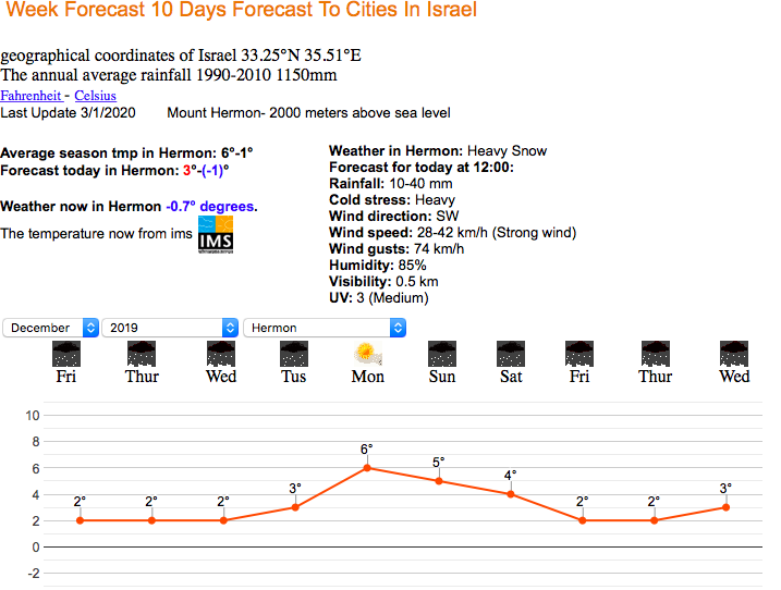
I have been to Israel twice. Really enjoy visiting...also, lots of microclimates. Check out the weather on Mt Hermon right now. Heavy snow and 74km/h winds. Check out the live web cam on top of the mountain...howling! https://www.skihermon.co.il/en/#videosection
-
December/January 2019/20 Winter Speculation Thread
Carvers Gap replied to AMZ8990's topic in Tennessee Valley
Must have placed this in banter accidentally... A slight glimmer of hope this AM...Both the 6zGFS and EPS-Control show strong heights building in the eastern Pacific with downstream troughing. Those runs in and of themselves are good. The actual EPS/GEFS ensemble depict an EPO ridge that is too far to the West and drops the trough into the West. What that means is that there are likely more members solutions to the West than East. However, with an operational and control showing an eastern trough...there is some(even if slight) possibility that the trough comes eastward. Just a guess, but I might suspect that we are beginning to see the first hints that modeling is going to change up the current warm pattern. Usually see some head fakes on operational runs before ensembles take hold. Still think we are at least a couple of weeks before we even hit the transition time frame. Still, we should see one cold shot around the new year prior to reverting to warm. What would be awesome is if that cold dug deep enough to set up the eastern trough early. So, maybe some slight hints by modeling that we might be moving to something consistently less than hostile by mid-January. -
Current weather in Bethlehem is 52F with a chance of rain...kind of sounds like the past few days here!
-
December/January 2019/20 Winter Speculation Thread
Carvers Gap replied to AMZ8990's topic in Tennessee Valley
And the QBO at 30mb has gone strongly negative this morning. It bounces around some, but we want it on the left of the column consistently. If it stays there, it raises the chances of high latitude blocking pretty significantly. Would have been nice to see it there in November, but that would have been an early flip. A cycle of the QBO takes about 28 months which means it stays positive for about fourteen months before going negative. It double dipped positive one cycle ago which coincides nicely to some pretty so-so winters. Pretty awesomely, December is month 14 of being positive...and there it sits as negative. Fingers crossed it doesn't stall, but that is a pretty good drop. Also, I am not sure what the time lag is regarding its effects on hemispheric circulation, but that is a pretty sharp drop and one would think the effects would be felt sooner than later since it is a wind reversal.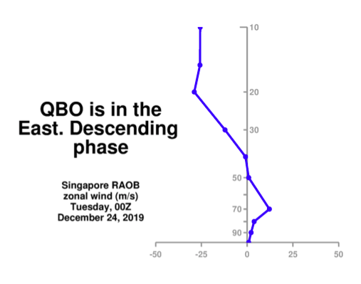
-
December/January 2019/20 Winter Speculation Thread
Carvers Gap replied to AMZ8990's topic in Tennessee Valley
And the SOI this morning is??? Hint: Google...Long Paddock and SOI.


