Carvers Gap
-
Posts
15,647 -
Joined
-
Last visited
Content Type
Profiles
Blogs
Forums
American Weather
Media Demo
Store
Gallery
Everything posted by Carvers Gap
-

December/January 2019/20 Winter Speculation Thread
Carvers Gap replied to AMZ8990's topic in Tennessee Valley
Looked a lot like the 12z Euro. The big thing of note are complete reversal of heights over Alaska. -
December/January 2019/20 Winter Speculation Thread
Carvers Gap replied to AMZ8990's topic in Tennessee Valley
Man, that is like night and day. I know it is an operational, but just going to enjoy that run. -
December/January 2019/20 Winter Speculation Thread
Carvers Gap replied to AMZ8990's topic in Tennessee Valley
How are we feeling about the 18z GFS? -
December/January 2019/20 Winter Speculation Thread
Carvers Gap replied to AMZ8990's topic in Tennessee Valley
12z EPS backed it up...welp. Very slight changes and could just be ebb and flow...yet another cool 12z run for the EPS. -
December/January 2019/20 Winter Speculation Thread
Carvers Gap replied to AMZ8990's topic in Tennessee Valley
But dang, it is about time for something to break....LOL. Maybe that is the beginning of a trend vs being an outlier. -
December/January 2019/20 Winter Speculation Thread
Carvers Gap replied to AMZ8990's topic in Tennessee Valley
The reason I don't buy the run is that the Euro looks like it over accentuates a hp dropping into Southern California early in the run. That slight accentuation allowed for an outlier PNA to pop. Europe warmth doesn't teleconnect well with eastern cold either. Don't get me wrong, I will take it...but looks suspicious. -
December/January 2019/20 Winter Speculation Thread
Carvers Gap replied to AMZ8990's topic in Tennessee Valley
Not sure that I buy it, but the 12z Euro just popped a western ridge and dug a huge eastern trough. Doesn't teleconnect well, but we'll take it...Europe is really warm. -
December/January 2019/20 Winter Speculation Thread
Carvers Gap replied to AMZ8990's topic in Tennessee Valley
The 0z GEFS develops a fairly strong block on the Atlantic side post 300. That is not a new feature. It has been gaining steam for a couple of days as the Hudson Bay AN anomaly that we have discussed. Good run. Also, nice run by the 0z CMC operational. I was not a huge fan of the 0z GFS operational. If given the choice, I will take a global ensemble over its operational. -
December/January 2019/20 Winter Speculation Thread
Carvers Gap replied to AMZ8990's topic in Tennessee Valley
The way that I view that is that it likely is going to move around some on future runs...just means that cold air is in play over NA - really cold air. Will be interesting to see the comments as the 18z GEFS rolls out. Some decent little changes there. Really, I kind of hold to the philosophy that getting cold into southern Canada or even the northern Plains just requires one storm to bring it down. What has been interesting is the block developing over Hudson Bay. While not a perfect block, it can act as a faux Davis Straits block. So, weathertree, we have to figure out how to survive a recurring case of the 0z (warm) yips tonight. I suspect we see a slight warm-up at 0z...been that way for weeks and could even be a total reversal of progress. What I can live with is two steps forward and one step back. I am really interested to see if the MJO continues to be adjusted to better outcomes. My fingers are crossed that we see further progress. -
December/January 2019/20 Winter Speculation Thread
Carvers Gap replied to AMZ8990's topic in Tennessee Valley
18z GFS with -73F at 252 over Greenland. -
You know it is an interesting weather pattern when the marching band semi has to fight its way through snow in the mountains just outside of....Los Angeles. They saw snow in Arizona and in much of the mountain ranges of Southern California. Heck, downtown LA looks sort of like Salt Lake City with the snow capped peaks in the background!
-
December/January 2019/20 Winter Speculation Thread
Carvers Gap replied to AMZ8990's topic in Tennessee Valley
I was looking at some old pics yesterday. One of my kids was holding a snow shovel that was taller than he was. Snow(that had been shoveled) was near his waist. -
December/January 2019/20 Winter Speculation Thread
Carvers Gap replied to AMZ8990's topic in Tennessee Valley
Again...the other deal that is a trend is AN heights over the Hudson Bay. Need to watch that. That has been going on since yesterday. Also, MJO will be interesting to look at tomorrow. -
December/January 2019/20 Winter Speculation Thread
Carvers Gap replied to AMZ8990's topic in Tennessee Valley
Agree. No way to know. It is actually very workable even by 10. The surface temps cooled 5-8F from the last run. Could switch back. That said, maybe our discussion about the old school AK vortex is not unfounded. In the mid-Atlantic, they referenced a paper stating that set-up usually teleconnects warm here. Sure seems like I remember seeing a cold Alaska as a kid and about a week later...it was cold here. Wonder if that study was just a snapshot in time, because sometimes those AK vortices will head SE, often actually. I do think there is plenty of uncertainty in the pattern. However, with the trend for the MJO to go further around the COD instead of across it...those types of runs should show up. Decent uptick in snow. The control has an event for I-40 north. But yeah, nice to see at least a hiccup...gives us a little bit of hope! -
December/January 2019/20 Winter Speculation Thread
Carvers Gap replied to AMZ8990's topic in Tennessee Valley
The 12z EPS moved off of its spot. No doubt about it. Again, another afternoon run that is cooler. If you can toggle 850 temps from d10-15 for each day...look at the difference. Also, look at the trends at 500. We won't know if this is trend or just a wobble. I wonder if afternoon convection in MJO regions is causing the 0z run to be warmer and/or the MJO to be slightly off? -
December/January 2019/20 Winter Speculation Thread
Carvers Gap replied to AMZ8990's topic in Tennessee Valley
I always sort of consider 2014-2015 as prime example of why analogs don't work. It had a lot of things working against a wintry pattern...but it just kept snowing. I give a lot of credit to the EPO ridge that just took over as the dominant driver. I think if the MJO would just fold into the COD for the rest of winter, the EPO ridge would slide eastward and send cold east of the MS. The MJO is pulling that EPO ridge just far enough back to make it warm here. -
December/January 2019/20 Winter Speculation Thread
Carvers Gap replied to AMZ8990's topic in Tennessee Valley
That is crazy, man! Wow. -
December/January 2019/20 Winter Speculation Thread
Carvers Gap replied to AMZ8990's topic in Tennessee Valley
Here are some things to watch in the long range as the EPS finishes its run. 1. The GEPS has flipped to a favorable pattern from 0z. 2. The GFS/GEFS are out of sync. 3. The Euro operational "found" some extreme cold in southern Canada - take a look at the run-to-run temp change over Quebec. Tells me there is reasonable if significant uncertainty after d7. One good storm and that is a phase 8 MJO look. 4. Heights in prime blocking areas have moved on operationals/ensembels to either neutral or negative. Starting to see the beginnings of a HB block on some modeling. That area is notorious to forecast and can flip quickly. I noticed the change at 0z(could have been their prior), but there is a trend over Hudson Bay and the Davis Straits towards higher heights. -
December/January 2019/20 Winter Speculation Thread
Carvers Gap replied to AMZ8990's topic in Tennessee Valley
And the more that the Euro/EPS adjust that MJO, the more likely we see some variable solutions in the future. Seems fairly locked into a western trough right now...but if it is wrong about the MJO, it may be way off. I do think the Euro has superior physics, but it missed in November pretty badly...actually the past two Novembers. -
December/January 2019/20 Winter Speculation Thread
Carvers Gap replied to AMZ8990's topic in Tennessee Valley
High amplitude 8/1 are pretty good signals for sever cold. However, not sure we want the MJO to be a driver at all right now...so low amplitude is fine by me. FWIW(huge grain), the 12z GFS takes us out of the crap pattern. The CMC is fairly similar but doesn't go out far enough to know if it has a similar outcome. GFS has had an awful cold bias after d8...but that run is indeed a break from continuity at 500. Could be a blip. Could be a change. -
December/January 2019/20 Winter Speculation Thread
Carvers Gap replied to AMZ8990's topic in Tennessee Valley
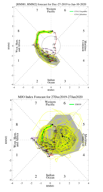
I don't know that the QBO and EMON are in sync. We will see where the QBO is in a week. A negative and falling QBO at 30mb should favor more blocking over the Davis Straits and cold in the East coupled with low solar. Phase 5 is not favorable for blocking there. I don't think EMON and QBO are in sync at the end of that run...but that depends on whether the QBO has stalled weakly positive. Should know in a week. If the QBO is falling and almost negative or just negative...there should be more blocking in favorable areas. The EMON is being shown because it keeps correcting away from unfavorable phases or at least pushing them back. Pretty sure it sent the MJO into 7 and looped it back into 5. It is now taking a low amplitude look into 8 before crossing back into four, ie it is pushing the unfavorable switch back further and further. But yeah, don't want it stalled in 5! LOL. Game, set, match if so. I just don't think it is right with that stall. But right now, I wonder if the MJO ever goes to those phases anytime soon. I did screenshot it today to see if it verifies. Not to Tellico...but just to others reading: I have noticed a general consensus towards warm across multiple tech platforms. I tend to dig around to see if there are counters to that consensus. I don't think the MJO is being modeled correctly. That would be a fairly big flaw. The PDO is showing some signs of flipping at least temporarily. So, I don't think warm is a slam dunk though I freely admit is has a roughly 60% chance of verifying in my book. I think the EPS is possibly correct. Problem is, its own MJO is trending towards cooler phases at low amplitude. It it was the other way around...cool phases trending towards warm phases at low amplitude, I would not be very confident of the cooler model run. Thus, I think that warmer model runs need to be viewed with at least a pinch of skepticism until/if the MJO makes that turn. -
December/January 2019/20 Winter Speculation Thread
Carvers Gap replied to AMZ8990's topic in Tennessee Valley
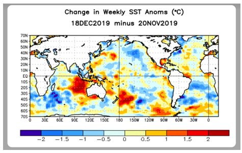
Before we get too deep into this conversation, let's cover the definition of the PDO. First, begin to look in the NE Pacific. A warm or positive phase according to at the NCSU climate site is a pool of cool water surrounded by warm. A negative or cool phase is warm water surrounded by cold. According to the NCSU site, the positive phase correlates quite well to BN temps over the SE. Now, remember all of that cold parked over Alaska. It is cooling the SSTs in that area. I know @nrgjeff mentions the PDO some...so credit there a well. So in digging around for some teleconnections that would actually point to a less torchy forecast, here we go... Here is the a graphic from JPL regarding PDO phases: https://sealevel.jpl.nasa.gov/science/elninopdo/pdo/ Here is a graphic CPC/NCEP ENSO update from December 23rd: https://sealevel.jpl.nasa.gov/science/elninopdo/pdo/ This is a comparative graphic of the NE PAC in early December and yesterday. Here is the graphic from NOAA/NESDIS: https://www.ospo.noaa.gov/Products/ocean/sst/anomaly/ Discussion: Note the cooling signal in the CPC/NCEP graphic. Now, the raw data for that area is still very warm. See the NESDIS graphic below it. However, the trend is very much towards a positive PDO - reference the JPL graphic. We are not there yet. However, it seems like the PDO is making an attempt to switch from the big orange blob to a much cooler signal surrounded by warmth along the coastal areas of Canada and AK. Look how warm the SSTs were in the GOA to begin December. It was basically basin wide warmth with cold tucked up along the Pacific Canadian coast which is a fairly strong sig of a negative PDO. Now, look at yesteday's SSTs. Anamolous cool temps are beginning to show up in the central North Pac. If the PDO flips positive, we cool off. I submit that we probably need to monitor what is going on in the NE Pac as it may very well be a quiet but important passenger riding along with the driver which is the MJO. In other words, it is a driver as well. If it continues to switch, that is in our favor.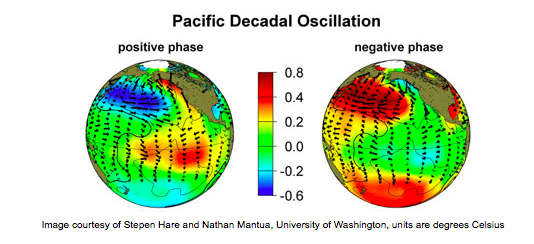
-
December/January 2019/20 Winter Speculation Thread
Carvers Gap replied to AMZ8990's topic in Tennessee Valley
One last thing that I usually follow during winter...Many places in the northern Rockies got a pretty good thump of snow in early December. However, there are many places at normal or even below normal(regarding snowfall) in parts of WY and MT. Some areas have been really hammered such as the southeast corner of WY. But I follow several FB pages that show photos of those areas. One pic around Gardiner, MT, basically showed bare ground. Now, that area gets less snow as it is a very dry micro-climate of the Greater Yellowstone ecosystem, but I am not seeing deep snow in the areas outside of YNP. That is right out of the El Nino playbook. So, makes me think that the El Nino pattern is still fairly locked-in. The Mountain West can give a lot of clues as to what happens here. Like John, I look upstream quite a bit. (BTW, a cold Alaska used to be an old school sign for cold here...I agree). I have always looked into that area for changes. Last winter, the cold banked into that region and they got hammered by an active jet during late January, February, and March. It will be interesting to see if that happens during this cold snap. If it doesn't, it tells me that the current pattern has less Nina characteristics than last year. They get hammered during La Ninas. JB did point out that the SOI should begin to sharply rise as there is a tropical system headed for that area. Should fall after it passes. Beware of comparisons to La Nina when that happens. There are some comparisons that are accurate, especially when one looks at the cool water near SA. The tropical system may create a false Nina signal - there are Nina signals out there but not that as much. It is sort of like a -NAO forming because a big ridge was forced into that region but quickly scoots out - basically an artificial NAO. Same thing upcoming with the SOI in my opinion. -
December/January 2019/20 Winter Speculation Thread
Carvers Gap replied to AMZ8990's topic in Tennessee Valley
...And one of the things that I look for is the model that mirrors the trajectory of the observed MJO without a sharp change in trajectory. This is why, contrary to the masses, that I am not going crazy about a warm-up after mid-month. It may happen...heck, it may likely happen. However, as long as that MJO forecast continues to correct and continues to push back(edit) the transition across the COD into warm phases...I am not going to play the "rest of winter" torch card quite yet. Here is a link to the CPC site. If you are new to the wx hobby(or even been in it for some time), good time to hone in on some new skills. Look at the site. Which models actually continue the current trajectory in a realistic manner? https://www.cpc.ncep.noaa.gov/products/precip/CWlink/MJO/CLIVAR/clivar_wh.shtml -
December/January 2019/20 Winter Speculation Thread
Carvers Gap replied to AMZ8990's topic in Tennessee Valley
Remember when the MJO was supposed to go into 6, then go to 7, and loop back into 5? The CFS is looking like it will score a very unlikely coup here. I think it was the only model(joined by the JMA) which actually took the MJO through cold phases. If you look, the MJO is gaining amplitude and the model has yet to catch up. See that sharp dive left by the green forecast line that seems out of sync with the observed red line. Likely means it still has some trajectory to gain unless it finally nails the turn...been doing this for a few days, at some point it has to be right? The CFS and EMON are now quite similar. The CFS is a bit slower. The EMON goes into 5 and dies which would effectively end any chance for January cold - but is it right? The EMON does now have a cluster of paths that go through 8 and 1. The JMA gains massive amplitude in 7. So, oddly similar conversation as last year. We are now watching the MJO correct. No loop back to 5/6 from 7. Makes me wonder if the Euro MJO forecast is right at all at this point and that should call into question its LR forecast. It might be correct. It might not. But if the MJO does go into 8, 1, and 2 would not surprise me to see a trough in the East for an undetermined amount of time. The MJO has shown during the past two winters that even at low amplitude, it affects downstream wx in signifiant ways. Something to keep an eye on, but that is a very different look that we started with.