Carvers Gap
-
Posts
17,470 -
Joined
-
Last visited
Content Type
Profiles
Blogs
Forums
American Weather
Media Demo
Store
Gallery
Everything posted by Carvers Gap
-

January 2021 Medium/Longterm Pattern Discussion.
Carvers Gap replied to AMZ8990's topic in Tennessee Valley
The 12z Euro is pretty much at the same place. Lots of high pressure over the northern tier of states. GOM begins to attack the cold. Lots of variations with the SER. We DO NOT want an absence of the SER, but just enough of an angle to send precip into the cold. Right now have to think the NW shield of those waves will be cold. Again, nothing set in stone. This could trend to a stronger SER and just be a ton of rain OR modeling could be underestimating the push of cold and we could be in business. We need the cold front around the 5th to blast through and not wash out. Then, we need the boundary to press SE of the area. That hasn't happened a lot this winter, but has generally produced when it has. The NAO seems to slow nearly every system over E TN just enough so that some frozen precip falls in those areas. This upcoming window is something that everyone can watch...Usual areas north of I40 are in better shape due to latitude. However, that is some crazy cold air in the front range of the Rockies. If any of that breaks loose and heads East...that is a good set-up. I know by this time of year most are fatigued from following system after system...but I am intrigued with this. -
January 2021 Medium/Longterm Pattern Discussion.
Carvers Gap replied to AMZ8990's topic in Tennessee Valley
Definitely have my eye on the 12z GFS Para(GFS has this as well). They both push the freezing line to our area our just past it. There are 2-3 waves which ride that front. Guessing the GFS is being overly aggressive with the cold. However, in the off chance that those are right, that would be a multi-wave overrunning event. Those happen, but has been a long time. Time frame is just after the 5th which is right around the much discussed trough amplification. -
January 2021 Medium/Longterm Pattern Discussion.
Carvers Gap replied to AMZ8990's topic in Tennessee Valley
Of note the EMON MJO looks really, really good. Think some of these colder solutions on various runs is due to the MJO flirting with very cold phases for February. -
January 2021 Medium/Longterm Pattern Discussion.
Carvers Gap replied to AMZ8990's topic in Tennessee Valley
What does natural gas look like today and/or energy futures? I never look at them, but if those start going up.... -
January 2021 Medium/Longterm Pattern Discussion.
Carvers Gap replied to AMZ8990's topic in Tennessee Valley
Euro Weeklies say winter is not over. Initial cold push around the 5th. About 6 days later the trough returns and slams the door on spring. As Boone notes, if the Euro is holding back a bit in the West, the entire trough could come east around the 5th and settles into a full latitude trough. Nice look. Let's reel it in. Basically the message is more cold than warm, but some warm still embedded after the 5th. Implies a late spring. -
January 2021 Medium/Longterm Pattern Discussion.
Carvers Gap replied to AMZ8990's topic in Tennessee Valley
The LR doesn't look half bad on multiple operational and ensemble runs. We will see how the pattern develops after the 5th. The 18z GEFS, after pushing the idea of a western tough, is not so much anymore. We will likely have a strong cold front around the 5/6th depending on our location in the forum area. After that is the topic of great discussion. Strong amplifications during February can be interesting. -
January 2021 Medium/Longterm Pattern Discussion.
Carvers Gap replied to AMZ8990's topic in Tennessee Valley
Still very much like the time frame after Feb5th. Take a look at the 12z GFS...hard not to like that run. The 12z GEFS is also nice in the direction it is heading. I don't think winter is over.
-
January 2021 Medium/Longterm Pattern Discussion.
Carvers Gap replied to AMZ8990's topic in Tennessee Valley
Evidently, the 12z GEPS has rediscovered the trough amplification in the East which it lost overnight. MJO is having some effect here I think.. Monster EPO and NAO block. Not saying that happens, but sharing the information from the run. -
January 2021 Medium/Longterm Pattern Discussion.
Carvers Gap replied to AMZ8990's topic in Tennessee Valley
That said, I really need to look at the MJO before I post. The EMON has the MJO going into phase 8, the GEFS is flirting with it, and the ECMWF is as well. IF that is the case, modeling should send that trough into the East. Those are not bad looks. That trough "should" kick eastward. Been following the TN coaching search while the wx is in lull, so take with a huge grain. -
January 2021 Medium/Longterm Pattern Discussion.
Carvers Gap replied to AMZ8990's topic in Tennessee Valley
If the EPO verifies, the EPS and GEPS will score the W. I am referring to the persistent SER on the GEFS. The EPS and GEPS have not had that until overnight for that time frame. I still think the cold will push as evidenced by the EPS Weeklies. But the GEFS look has been the lesser(re:winter) of the three IMO. -
January 2021 Medium/Longterm Pattern Discussion.
Carvers Gap replied to AMZ8990's topic in Tennessee Valley
Quick note: Looks like the GEFS has pulled the coup in the LR which means its depiction of a warmer phase MJO is looking more likely to verify. The EPS and GEPS have both moved towards GEFS solutions. They push a front through around or just after the 5th, but quickly return the trough the the Mountain West. We will see if that holds as there are many questions as to where the MJO goes after phase 7. To me, it looks like it goes to 8, but we will see. -
January 2021 Medium/Longterm Pattern Discussion.
Carvers Gap replied to AMZ8990's topic in Tennessee Valley
RGEM has been missing changeover times here by a fairly wide margin. It does a great job though of identifying a threat and remaining consistent if real. The Euro actually nailed the snow here last Thursday which Is why I want it on board. When both the RGEM and Euro have something short range, I feel pretty good about the chance of occurrence. -
January 2021 Medium/Longterm Pattern Discussion.
Carvers Gap replied to AMZ8990's topic in Tennessee Valley
Think it is going to be a month where troughs move east, lift out, reload, and happens again. The SER will slip in between those troughs at times. At this point, that is just a timing issue. I don't think I have seen a single person calling for sustained cold, but....this is a pattern which could produce as nearly every cold shot has produced frozen precip this winter in this forum area. -
January 2021 Medium/Longterm Pattern Discussion.
Carvers Gap replied to AMZ8990's topic in Tennessee Valley
Just to re-iterate what we have been saying for several days, the 12z EPS and GEPS are still advertising a strong trough amplification in the East around Feb5th. As noted, the changes which force the trough eastward on those models are now almost at d10 with the trough following soon after. The 12z EPS is stronger and very slightly faster (w just a quick glance). Euro Weeklies look like periodic shots of cold throughout February. It is worth noting that the 12z GEFS remains steadfast in its depiction of an eastern ridge. At this point the MJO has a strong say in what happens downstream and obviously the GEFS and EPS are much different with their indices in the mid to late range. -
January 2021 Medium/Longterm Pattern Discussion.
Carvers Gap replied to AMZ8990's topic in Tennessee Valley
It still is my favorite for sure. -
January 2021 Medium/Longterm Pattern Discussion.
Carvers Gap replied to AMZ8990's topic in Tennessee Valley
Only problem I have with the RGEM/CMC combo is that it has been a hair too cold IMBY which is causing it to overestimate snowfall here - matters especially when changeover times matter. -
January 2021 Medium/Longterm Pattern Discussion.
Carvers Gap replied to AMZ8990's topic in Tennessee Valley
Want to see the Euro on board for NE TN...has been really good this winter when it showed snow here and when it did not. -
January 2021 Medium/Longterm Pattern Discussion.
Carvers Gap replied to AMZ8990's topic in Tennessee Valley
EPO ridge is at d9-10 on both the 12z GEPS and 12z EPS which is less unreliable time - bit quicker on the GEPS. So the driver to move that western trough eastward is not at d14, but is actually at d9/10. Certainly no certainty even at that range, but that is not d14 stuff I am noting. -
January 2021 Medium/Longterm Pattern Discussion.
Carvers Gap replied to AMZ8990's topic in Tennessee Valley
12z EPS is snow also showing a similar strong amplification around the same time frame - Feb 5/6(we can use that time as a benchmark). Been moving up in time fairly consistently. -
January 2021 Medium/Longterm Pattern Discussion.
Carvers Gap replied to AMZ8990's topic in Tennessee Valley
The d10-15 5 day mean for the GEPS is just sick in regards to the EPO. Wow - reaches to the Arctic Circle. -
January 2021 Medium/Longterm Pattern Discussion.
Carvers Gap replied to AMZ8990's topic in Tennessee Valley
EPO ridge on the 12z GEPS is just nuts. The 12z EPS which is running is not far from that solution. -
January 2021 Medium/Longterm Pattern Discussion.
Carvers Gap replied to AMZ8990's topic in Tennessee Valley
0z UKMET on Pivotal was interesting re: snow accumulation trends. -
January 2021 Medium/Longterm Pattern Discussion.
Carvers Gap replied to AMZ8990's topic in Tennessee Valley
Really it is almost a slider for the length of the TN/KY border - 12z Euro is much colder. -
January 2021 Medium/Longterm Pattern Discussion.
Carvers Gap replied to AMZ8990's topic in Tennessee Valley
The 12z Euro is very close for portions of NE TN. The WxBell snow graphics actually have all snow(with little accums) for Sullivan and Washington Co's and NE. -
January 2021 Medium/Longterm Pattern Discussion.
Carvers Gap replied to AMZ8990's topic in Tennessee Valley
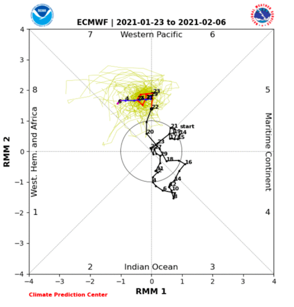
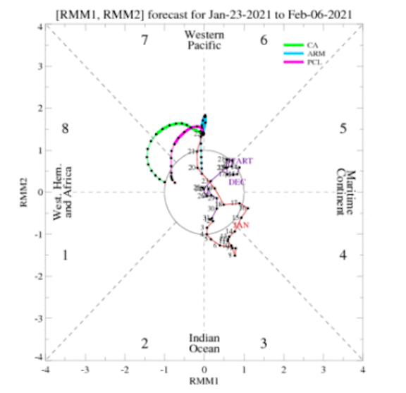
Two thoughts... 1. I think NE TN, SW VA, and SE KY are going to have to keep an eye on the system just after 100. The 6z GFS and 0z CMC both pop a lee side low or inland runner after energy transfer up the Piedmont/Coastal Plain. Now, I am not a huge fan of energy transfer, but if the energy transfer were to occur far enough to the southeast, one could see rain changing to snow in the aforementioned areas. Bit of a long shot but it has been my experience that these types of handoffs tend to run a snow axis from Bristol to DC. 2. MJO. Some modeling stalls the MJO around 6-7. However, wanted to share a couple from this morning (ECMWF and CA-LLR) which actually move the MJO along. Some MJO modeling actually produces another wave off of Eastern Africa and rolls it eastward. If that happens, that means the MJO rolls through phases 1, 2, and 3. You can see on the CHI map that very wave beginning just after d5. ECMWF(notice it head towards 8) CLA is about perfect... CHI Propagation Map from yesterday as today is not updated for this yet(look specifically for the way around Africa move to the central IO....that is MJO 1-3 which is cold for JFM) That is one window for potential cold. It is on modeling and there seems to be some moderate agreement among MJO modeling. FTR, I think the MJO is now driving the boat in terms of temps. The -NAO seems to be driving the storm track. So, the 0z GEPS and 6z DFSv2, which pop significant EPO ridges are showing the cold potential(as opposed to the very real warm potential scenario) for just after the 5th. Could it be a mirage? Sure, but I don't need to provide all of the caveats. The above is a great example of why modeling is struggling. I tend to think we see the cold move East...so I am tentatively rolling with cold pushing East around the 5th(likely gets pushed back a few days as cold often can), but that is my current thinking.