-
Posts
17,430 -
Joined
-
Last visited
Content Type
Profiles
Blogs
Forums
American Weather
Media Demo
Store
Gallery
Everything posted by Carvers Gap
-

January 2021 Medium/Longterm Pattern Discussion.
Carvers Gap replied to AMZ8990's topic in Tennessee Valley
Only problem I have with the RGEM/CMC combo is that it has been a hair too cold IMBY which is causing it to overestimate snowfall here - matters especially when changeover times matter. -

January 2021 Medium/Longterm Pattern Discussion.
Carvers Gap replied to AMZ8990's topic in Tennessee Valley
Want to see the Euro on board for NE TN...has been really good this winter when it showed snow here and when it did not. -

January 2021 Medium/Longterm Pattern Discussion.
Carvers Gap replied to AMZ8990's topic in Tennessee Valley
EPO ridge is at d9-10 on both the 12z GEPS and 12z EPS which is less unreliable time - bit quicker on the GEPS. So the driver to move that western trough eastward is not at d14, but is actually at d9/10. Certainly no certainty even at that range, but that is not d14 stuff I am noting. -

January 2021 Medium/Longterm Pattern Discussion.
Carvers Gap replied to AMZ8990's topic in Tennessee Valley
12z EPS is snow also showing a similar strong amplification around the same time frame - Feb 5/6(we can use that time as a benchmark). Been moving up in time fairly consistently. -

January 2021 Medium/Longterm Pattern Discussion.
Carvers Gap replied to AMZ8990's topic in Tennessee Valley
The d10-15 5 day mean for the GEPS is just sick in regards to the EPO. Wow - reaches to the Arctic Circle. -

January 2021 Medium/Longterm Pattern Discussion.
Carvers Gap replied to AMZ8990's topic in Tennessee Valley
EPO ridge on the 12z GEPS is just nuts. The 12z EPS which is running is not far from that solution. -

January 2021 Medium/Longterm Pattern Discussion.
Carvers Gap replied to AMZ8990's topic in Tennessee Valley
0z UKMET on Pivotal was interesting re: snow accumulation trends. -

January 2021 Medium/Longterm Pattern Discussion.
Carvers Gap replied to AMZ8990's topic in Tennessee Valley
Really it is almost a slider for the length of the TN/KY border - 12z Euro is much colder. -

January 2021 Medium/Longterm Pattern Discussion.
Carvers Gap replied to AMZ8990's topic in Tennessee Valley
The 12z Euro is very close for portions of NE TN. The WxBell snow graphics actually have all snow(with little accums) for Sullivan and Washington Co's and NE. -

January 2021 Medium/Longterm Pattern Discussion.
Carvers Gap replied to AMZ8990's topic in Tennessee Valley
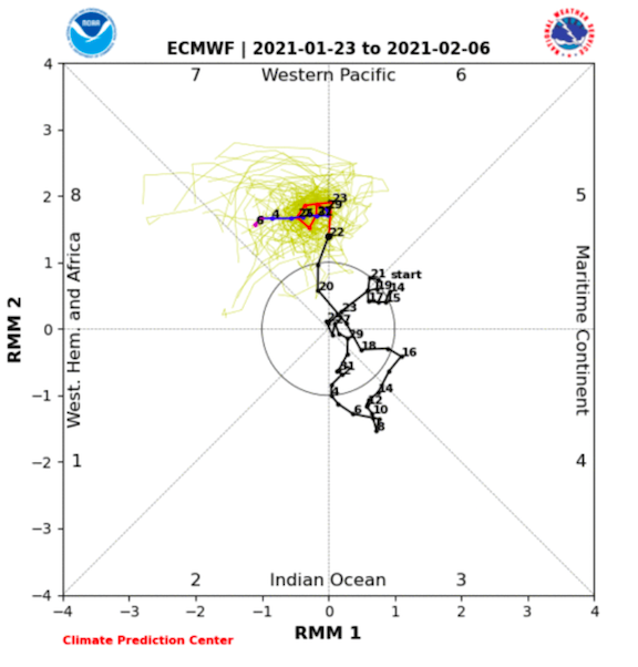
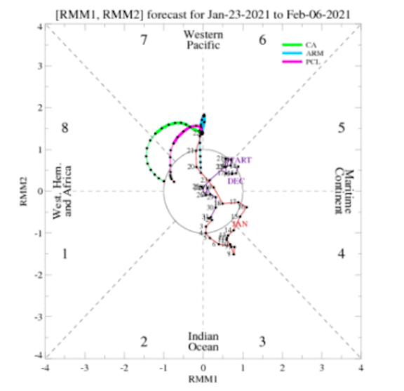
Two thoughts... 1. I think NE TN, SW VA, and SE KY are going to have to keep an eye on the system just after 100. The 6z GFS and 0z CMC both pop a lee side low or inland runner after energy transfer up the Piedmont/Coastal Plain. Now, I am not a huge fan of energy transfer, but if the energy transfer were to occur far enough to the southeast, one could see rain changing to snow in the aforementioned areas. Bit of a long shot but it has been my experience that these types of handoffs tend to run a snow axis from Bristol to DC. 2. MJO. Some modeling stalls the MJO around 6-7. However, wanted to share a couple from this morning (ECMWF and CA-LLR) which actually move the MJO along. Some MJO modeling actually produces another wave off of Eastern Africa and rolls it eastward. If that happens, that means the MJO rolls through phases 1, 2, and 3. You can see on the CHI map that very wave beginning just after d5. ECMWF(notice it head towards 8) CLA is about perfect... CHI Propagation Map from yesterday as today is not updated for this yet(look specifically for the way around Africa move to the central IO....that is MJO 1-3 which is cold for JFM) That is one window for potential cold. It is on modeling and there seems to be some moderate agreement among MJO modeling. FTR, I think the MJO is now driving the boat in terms of temps. The -NAO seems to be driving the storm track. So, the 0z GEPS and 6z DFSv2, which pop significant EPO ridges are showing the cold potential(as opposed to the very real warm potential scenario) for just after the 5th. Could it be a mirage? Sure, but I don't need to provide all of the caveats. The above is a great example of why modeling is struggling. I tend to think we see the cold move East...so I am tentatively rolling with cold pushing East around the 5th(likely gets pushed back a few days as cold often can), but that is my current thinking. -

January 2021 Medium/Longterm Pattern Discussion.
Carvers Gap replied to AMZ8990's topic in Tennessee Valley
Again, I think we potentially may see a major trough amplification around or just after the 5th. The 0z GEPS has a monster EPO ridge moving forward in time on its 0z run. If the air in front of that sharp trough is warm enough, could be fireworks for sure. The 0z EPS is not far behind but its Pacific ridge is displaced further west. As Webber noted the other day, there is a super fine line between torch and major league cold. Modeling is now moving up in time that Feb 5th timeframe. This is the first winter in a while where I don't remember tracking at least some severe wx, so a big amplifying trough with warm air in front is definitely a good recipe. Almost has a "flooding and then snow" look. Again, I look for the coldest air to go into the front range of the Rockies and surge eastward 2-3 times in February. Only concern would be a repeat of November.... -

January 2021 Medium/Longterm Pattern Discussion.
Carvers Gap replied to AMZ8990's topic in Tennessee Valley
Pretty interesting to see the 18z GEFS "cave" to the 12z EPS re: the position of the ridge in the eastern Pac. The GEFS has been stubborn in pushing that ridge well of the coast and allowing the trough to run well into the west. At 18z, the GEFS now has the trough up against the coast...and bang, EPO ridge just after d10. All of that can change at this range, but good trends. -
Yeah, we should have gone with a thread for that one this morning. There was plenty of model support. I just thought I was nuts since it didn't get more attention. @kvskelton, great pics!
-

January 2021 Medium/Longterm Pattern Discussion.
Carvers Gap replied to AMZ8990's topic in Tennessee Valley
You know, that 18z GFS storm at 162 is super close to being a big storm for E TN. Big high over the stop and nearly perfect placement. If it turns the corner and trends slightly NW(which is entirely possible...boom. -

January 2021 Medium/Longterm Pattern Discussion.
Carvers Gap replied to AMZ8990's topic in Tennessee Valley
Beginning to spitball a major trough amplification over North America late during the first week of February. Could easily change. That said., the 12z EPS actually splits the western NA trough around 240. That has moved up in time quite a bit. Fits with the operational quite well. Trough retrogrades into Canada, ridge builds in the West and sends a lobe of BN into the SE around d10. Eventually the AK vortex slips SE into the nation's mid-section. Makes me think that the MJO is maybe going to slip over into 8 or COD by late in week 2. Honesty, the last few hours of the EPS are the best look we have had all winter. Not a lot of skill at that range for the model, so will just refer to the 5d mean above. Just picture the bluest shaping places with the light blue for d15. -

January 2021 Medium/Longterm Pattern Discussion.
Carvers Gap replied to AMZ8990's topic in Tennessee Valley
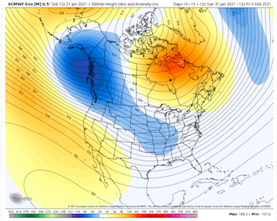
This is the d10-15 5day mean from the 12z EPS. Weeklies aren't bad...get really good around mid-Feb. That said, I think the transition to a better pattern was actually sped up on the 12z run. 12z was a substantially better run. Again, this is a 5d mean. D15 basically drops the core of BN 500 heights into the Plains and spreads eastward. Classic cold air delivery mechanism for winter. Notice the trough building into the west. It is possible the trough could even split like we had during December. -
One local school system had kids get caught mid-bus route and school was called. Was a huge mess in parts of Sullivan and SW VA. Euro nailed this. Just drizzle now.
-
Higher elevations around town have a decent dusting. Once you hit the EB, it is all rain. Was very marginal in terms of temps. Glad you all scored up that way. Was a nice surprise!
-
That is awesome. A solid dusting here.
-
Silver dollar snowflakes coming down here. Super light dusting. Doesn't look like it will last long, but impressive nonetheless. Modeling has done really well with this system in terms of precip type and timing for several days. Showed basically a sloppy mess. Sure enough.
-

January 2021 Medium/Longterm Pattern Discussion.
Carvers Gap replied to AMZ8990's topic in Tennessee Valley
The last two times we have seen significant cold predicted(and did not occur) was for early Jan and now late January. Those two "busts" by modeling are likely (but not totally) attributed to SSW events that have thrown off modeling which occurred during those time frames. The good thing is that we still had chances as modeling eventually trended back to a moderated cold shot. I suspect we see this again. -

January 2021 Medium/Longterm Pattern Discussion.
Carvers Gap replied to AMZ8990's topic in Tennessee Valley
Honestly, I have shared privately that we might have 2-3 legit windows this winter. So far we have had one right around Christmas - maybe another minor window to begin January. I suspect we get one more good one. Wavelengths will shorten up during February. I don't really sweat the "it's always at d10" stuff. We all know how that works. And again, when we are talking about the MJO, usually the pattern is not good. -

January 2021 Medium/Longterm Pattern Discussion.
Carvers Gap replied to AMZ8990's topic in Tennessee Valley
I think you all need to dig back through the winter spec thread. Lots of great thoughts there by many posters! I think most of us were super clear about the difficulties of moderate Nina winters. I don't always get a seasonal forecast correct, but this has worked out pretty well so far regarding temp and pattern stuff. Precip idea is too dry. Those ideas were posted during June. Here are some excerpts. Can't say you weren't warned well in advance... "Best chances for snow will occur late November into early January. Expecting a big thaw in January this year, BUT I do think we see bouts of serious cold this winter despite my AN temps forecast. I was really bullish at the end of last winter regarding the upcoming winter being a dud. And it may well be. Strong to moderate La Nina's are generally a non-starter IMBY. The good news, as I have stated before, is that we really need the Pacific to cool down some, and it has been some time since we have seen a strong La Nina. Winters that have followed strong La Ninas can be pretty good in MBY, so I will suffer through a strong Nina event if need be this winter..." "....As for snow, everybody wants to know how much we are going to get. The answer is that it is absolutely impossible to know. I think our best chances will be early. After that, one would think that January and February will provide some very long timeframes between chances. That said, it just "seems" the weather pattern from the past two years right is switching up. We are out of shoulder season which fooled me into thinking the pattern had broken early last winter(the pattern being a little pocket trough forming ad nauseam over the Mountain West in the front range). With some big heat already being felt in the Mountain West and a transient ridge reforming every few weeks there...makes me think we are seeing a transition. So, I am less negative about the upcoming winter. My gut says it will be better than I describe above, but my brain says to beware of moderate to strong Nina patterns - they are generally hostile to winter in the SE. So, I will go with BN snowfall, but maybe closer to normal than many will forecast, but better than last winter. Short and sweet with no graphics." -

January 2021 Medium/Longterm Pattern Discussion.
Carvers Gap replied to AMZ8990's topic in Tennessee Valley
Nah. Definitely is much different than last year. We have had a lot more snow in our area. We have a -NAO. Pacific like last year is not cooperating. Atlantic is nearly perfect. I am not a fan of the SSW stuff. I feel like that works for us sometimes. This year, those SSWs fouled what was a good pattern. Honestly, this year I didn't expect much. Think my winter forecast is in the winter spec thread. I normally don't bang my own drum, but was pretty clear that we would have long pauses between events. Moderate Ninas are a pain. Now, do I think we eventually get some more cold? Sure. I will try to link that forecast here. Give me just a sec.... -

January 2021 Medium/Longterm Pattern Discussion.
Carvers Gap replied to AMZ8990's topic in Tennessee Valley
The 12z GEPS at 500 past d10 is a beauty.


