

Carvers Gap
-
Posts
15,665 -
Joined
-
Last visited
Content Type
Profiles
Blogs
Forums
American Weather
Media Demo
Store
Gallery
Posts posted by Carvers Gap
-
-
3 hours ago, John1122 said:
A winter observation, we didn't get nearly as much snow as we normally should've for a January that's -10ish. I mean not even 50 percent of what a January like that normally brings. My electric bill came today and it's 200 percent of normal. So there's that.
I'm afraid to look at mine.
-
 2
2
-
-
36 minutes ago, jaxjagman said:
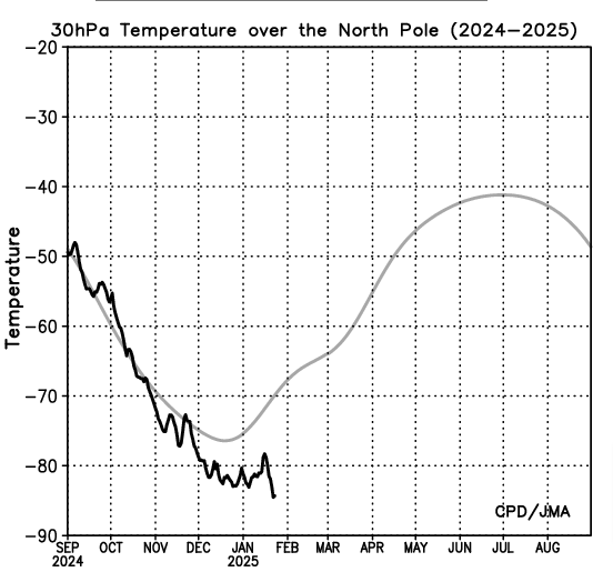
I'd like to understand more about the solar cycles and why people even try and incorporate them into seasonal forecast.In 1996 we had back then one of the strongest PV's on record only to get surpassed by the 2020,this year the PV has been relentlessly strong even without a solar min.I'm just using 30hPa as reference what JMA shows
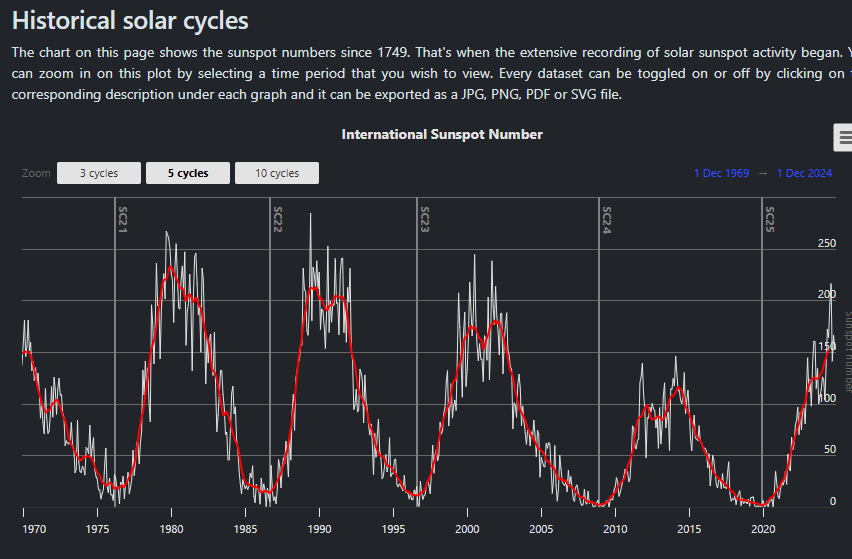
I think the sun matters a lot. In fact, it might the driver of Earth's weather over millennia. I just don't think we have a lot of research about how it impacts weather. It might be worth its own thread. I could write several posts on the topic. Briefly, I would say that increased solar activity tends to put a ridge over the eastern US.
-
2
-
-
Pretty big model war between the EPS/GEPS vs GEFS at 12z for d10-15. Last time the GEFS didn't do so well. However, what we are seeing is for sure differences in how the MJO is modeled both in amplitude and speed. It could be a thaw or a pattern change. I like the EPS right now as it tends to do a little better once we hit mid-winter. Total crapshoot though until the MJO gets sorted out. But I do know this 100%...when we start talking about the MJO, it is about to get really warm for an undetermined amount of time. For now, I think we see a warm-up from Jan 28 to Feb 7th. It could be longer. Outside chance it could be shorter. The SER is going to flex. We just don't want it to become a standing wave.
-
 1
1
-
-
The 12z GEPS and EPS are not warm in the long range. In fact, the EPS has a full blown trough progressing eastward from the nation's mid-section between d10-15. The AIFS does get my attention, but it can swing wildly at that range....sometimes it can lead the way. Just really watching to see if this is a thaw or a new pattern w/ a big SER. I lean temporary thaw, but am not totally sold on that yet. All it will take is one big cutter right along the MS River, and that cold air will refill eastern NA. Tricky business. Also, it is a good rule of thumb(and I forget it often) that sever cold over NA does wonky stuff to modeling.
-
 1
1
-
-
Snow showers in NE TN. Models had this. It was completely ignored.
-
3
-
-
The deck is also stacked a bit differently this year. NA is much colder than recent winters. We likely don’t have to rebuild the could source in Canada after the warmup. Cold sources matter.
-
2
-
1
-
-
The American modeling handles the MJO very differently. The Euro tends to underestimate amplitude. American modeling has a bias for stalling in 6 IMHO. It is going to warm up. We just need it to hustle! Most good winters have warm MJO rotations. We called them thaws. Now, we know some of the science. The MJO can also end winter. Deterministic modeling can just about see to the second week of Feb. We will know the verdicts to our questions soon.
-
1
-
-
1 hour ago, nrgjeff said:
Valentines Day and Presidents Day have been good to me both in Appalachia (skiing) and back in the Plains growing up (imby). One year I failed to prep my Valentines for school. Rescued by a snow day!
As for the 11-15 day period, most AI versions of Ensembles ooze the cold east eventually. GEFS does too. EPS and AIFS are a little slower and start warmer. EC warmer than USA stuff is kind of back to normal. I figure a slow go but eventually cold finds its way back in here. Favors BNAwx timing after the 11-15 day, more toward Day 20.
We're also waiting for convection to gtfo the Maritime Subcontinent. When it shifts we can perhaps get more love from the MJO, again that Day 15-20 timing. Weekly models like days 15-20 also.
Convection in the MC is a pain in the neck! LOL. I think we get one more meaningful rotation through cold phases. I think the worst of winter’s cold is behind us. That said, December featured that 11-12 day warmup. We may see something similar at the end of this month and early Feb. But yeah, if we want the warmup to be a thaw and not a toasty Feb….the MJO has to get out of 6!
To clarify…worst of cold behind us. But I have no idea about snow. Feb can deliver when it is on!
-
3
-
-
I "think" we are looking at potentially very cold temps during the second week of Feb. The AIFS at 12z hinted at this. It is there about 2/3 of the time.
@Daniel Boone, I suggested(then deleted quickly!) that we start a February thread. I thought I was in the January thread. No, I was actually IN the new February thread asking for the February thread to be created!!!! LOL!!!!
-
1
-
 3
3
-
-
6 hours ago, Knoxtron said:

In all seriousness, man the long range sure wants to load up the upstream/front range with extreme cold poised to dump our way again in Feb. Maybe we get a little SER to push against and slow down the stall line?
idk what I'm talking about, but I stayed at a Holiday Inn last night so
I like that meme, man. I am gonna use that for personal use.
-
3
-
-
Speaking of the "fun begins at 50," do I dare admit that I thought I was in the January thread when I recommended a February thread get started?
...and I was actually posting in the new February thread.


-
2
-
 1
1
-
-
I think the warmth we are seeing (to end the month and begin Feb) is the model reaction to the MJO passing through phases 4-6. So far(famous last words), that looks like a pretty fast pass. I was a bit perplexed that it hadn't shown up. At one point there were below zero temps in the middle of my warm-up! It is always possible that winter doesn't return, but I am rolling with '96 which had a warm-up in between cold shots. Right now is halftime - I think. A January thaw is almost always a staple of winter, and quite honestly, I could use one. The treadmill sucks for running! I don't do single digit wind chills. I am older and smarter... As one in my family likes to state, "The fun begins at fifty." Somehow, I don't think that is a compliment!!!
-
2
-
-
Here is the time frame that I continue to watch along with the timeframe around roughly 1/30(give or take a few days). The real question in my mind is where does the stationary front set up shop? Is it the Cumberland Plateau or the Apps? I have asked that question already once this winter. Turns out, it was Pensacola! This time frame sits just beyond deterministic and global ensemble range. Gonna have to slog through a ridge or two to get to potentially this - beware!
-
5
-
1
-
-
The 18z GFS just hammered the Southeast(portions of TN included).
-
4
-
-
The 18z GFS is interesting at d10.
-
6
-
-
29 minutes ago, david30 said:
Hopefully will be enough to close up the snow hole over Nw MS.
Mississippi is always a tough sell for snow, but I admittedly don't watch MS much during winter. If the cold is deep enough though, it could. Northern MS is in the game in my book if overrunning persists on modeling.
-
2
-
-
Just looking across deterministic runs d10-15, there is decent agreement of very cold air invading the Lower 48 again. To me this looks like a front range(of the Rockies) or Plains initial shot. Then the real question that arises is how far to the east does it spread. All three globals have cold racing down the Canadian Prairies at the end of their runs. The Euro manages to get the cold all the way to the Gulf Coast yet again. The Euro has a fairly extreme blocking scheme over Alaska. That is the mechanism that was missing yesterday. I still think the cold (potential)shot is just at the fingertips of deterministic runs and we will see variation for sure. I get pretty excited about cold during February. We haven't had a lot of that recently. Cold February storms will often over perform which is why they are fun.
-
6
-
 1
1
-
-
The biggest thing I have to change(in my thinking) is now climatology supports heavy snow in the Florida Panhandle. LOL.
-
5
-
-
On the 12z Euro, it looks like a dam break(d12-16)....the entirety of the cold airmass in Canada heads south. BIG differences in the MJO. American modeling seems to have moved markedly to the Euro camp overnight.
-
2
-
1
-
-
12z Euro is crazy cold late in the run....might be the coldest air mass of the season if it verifies.
-
3
-
1
-
-
The SER is also showing up in d10-15 as well. That probably teleconnects well to the MJO phase. Looks a lot like phase 7. Now, we just need to get it around into 8-1-2 without a stall(probable).
-
1
-
-
2 hours ago, *Flash* said:
Certified wild, ya'll. For our areas, I'd say this winter is on pace for 'Could have been better, could have been worse' territory. We'll see how February/March fills this in...
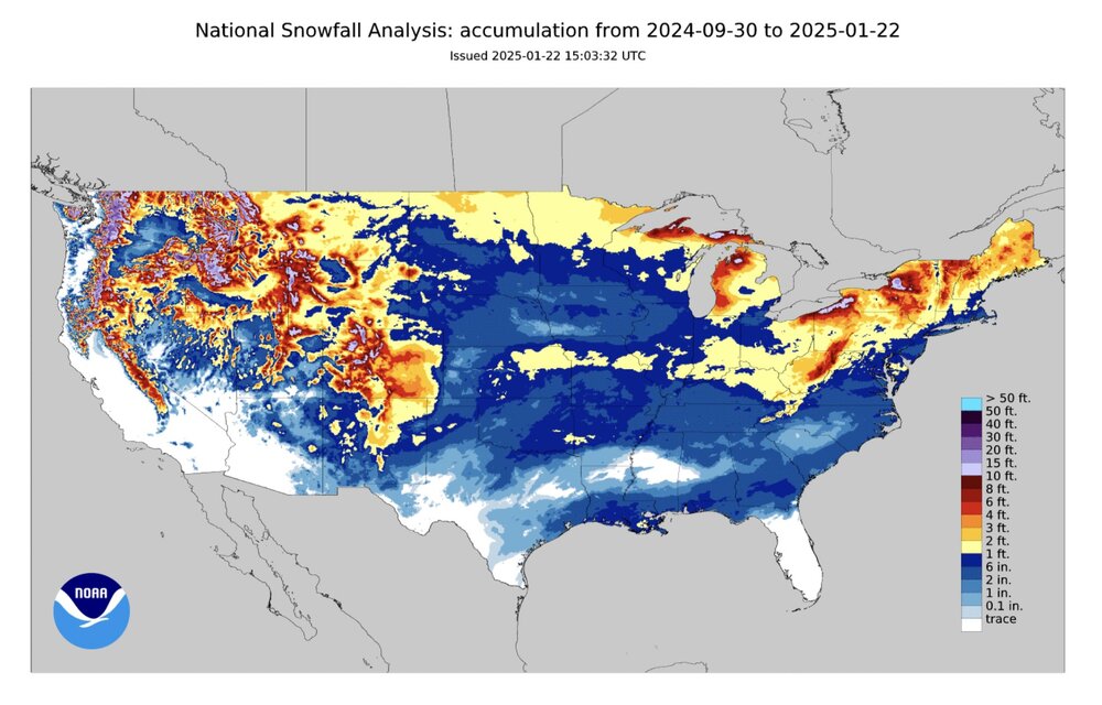
Areas which have under performed would be the Plains(that might get fixed during Feb) and the NE Coast. W VA is just racking up snow. The southern reaches of the Sierras (just eyeballing) could use some more snow. The Gulf Coast is set for the next 50 years.
-
1
-
-
Intense cold in January can result in cold/dry. Intense cold during February can yield big winter storms in the Lower 48. Models will often underestimate the strength of storms(northwest jog) and underestimate precipitation amounts.
-
4
-
-
9 minutes ago, WinterWonderland said:
Carver, you meant February, right?
Yeah, sorry. You can see modeling adjusting today towards that faster MJO rotation. The 12z GFS has it.
-
2
-
Winter 2024/2025 February Thread
in Tennessee Valley
Posted
Overnight and early morning ensembles depict the GEPS/EPS vs the GEFS after Feb7th. The first two ensembles take us below normal yet again. The second gets there, but only marginally. Worlds apart at 500. Their MJO plots are also worlds apart.