87storms
-
Posts
7,784 -
Joined
-
Last visited
Content Type
Profiles
Blogs
Forums
American Weather
Media Demo
Store
Gallery
Everything posted by 87storms
-
i can honestly say i don't care too much what amounts we end up with, though i still think we do fine as the system takes shape and starts to transfer it's energy to the coast. it's just nice that it's a weekend and we have a long duration snow to experience. it's only jan 12. even if we end up with 2-3", we have plenty of time for a bigger event. with that said...radar looks decent. i expect the lull to fill in a bit to the west as the precip gets shunted to the east as it runs into that stout high. just got home from hitting the gym and flake size was ideal...just need the rates.
-
This is gonna be an easy warning level snow here. Thought it would take longer to start sticking but...mid January...
-
Some street stickage here already. Steady light snow. Game on. Edit: more like steady here and sticking to everything.
-
it really is another very healthy run. if it's right, then totals may need to be nudged up a little, but i'd side with the euro at this point. plenty of energy to move through all day tomorrow. could be a sunrise to sunset snow.
-
1" qpf line creeping up towards dc again this run. looks like things are pretty set at this point.
-
dc is pretty much squarely in the 0.5-.75"+ at this point.
-
nam looking good again so far.
-
Light flurries by the 270 split.
-
smidge north than the 6z run. at this point, i think we're pretty solidly into a 4-6" event. whatever else falls is gravy. gonna step away for a bit and save my energy for the show. side note: looking at some of the wind maps...surface/850 circulation looks to really takeover near sunrise tomorrow, so i think that's when the real good stuff arrives. just how far north it gets is probably the wildcard for the bigger totals near dc.
-
notably better than 6z, just not the nam. another nudge north approaching gametime.
-
rgem nudged north. it's not a wallop like the icon and nam, but a good trend.
-
I was getting hyped with just the combo of 0.5” qpf and temps in the 20s. That was a legendary nam run. Gotta take it with a grain of salt, but maybe it’s a signal we’re a little closer to coastal impacts than previous runs suggested.
-
Best Mid-Atlantic winter storm of the last 40 years
87storms replied to PrinceFrederickWx's topic in Mid Atlantic
1996 was the mid atlantic mother ship event, but 2016 was the best snowstorm from start to finish. i stayed in the light snow during the lull so that helped. it's probably my #1 storm now, simply because there was little if any sleet. just a good ole fashioned blizzard. 96 and 03 round out my top 3 with feb '10 a close 4th. i do flip flop on these rankings, so ask me in a year and these might be shuffled primarily because they were all great in their own way. -
Might be able to snag some fringe light snow with the upper level part, but overall quite a miserable storm for our area. Perfect temps. But for whatever reason, these storms just want to stay suppressed similar to last year. Definitely need that pattern reboot that looks to be coming later this month based on the LR thread. On the bright side, it’s only December 9th.
-
they need a 3rd goto scorer at the 3 or 4 position. in storm news...i'm very much still in. gotta think it's all about the northern stream at this point and how much of a road block it will be in early december. usually we worry about temps at this time of year, so i have some doubts about how suppressed this storm will be. maybe we can fringe our way to a moderate storm...or in the wizards case, a 6th thru 8th seed.
-
i have fam in va beach so i'm rooting for you all. we got another car topper here. sandbridge is a great little beach...would be cool to be there during a snowstorm.
-
The August 21, 2017 Great American Eclipse
87storms replied to ice1972's topic in Weather Forecasting and Discussion
the eclipse was kinda cool even in md. i ended up making a cereal box projector lol. kinda lame, but it did work. i ended up taking the afternoon off from work and went biking and noticed a definitive dimness during the peak time which lasted a couple minutes. -
compared to last year i feel like this summer has been very tame. definitely worse out west it seems. i could be wrong, but i don't think we've hit 100 yet and not too many upper 90s days.
-
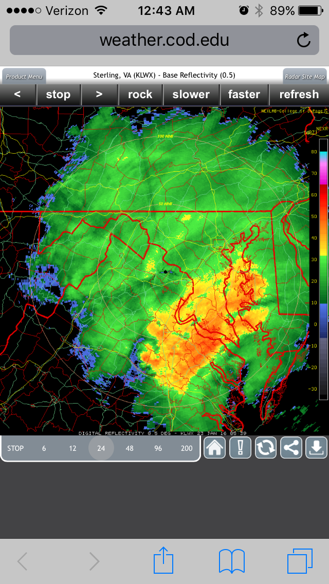
January 22/23 2016 images archive thread
87storms replied to Midlo Snow Maker's topic in Mid Atlantic
woof
-
Best Mid-Atlantic winter storm of the last 40 years
87storms replied to PrinceFrederickWx's topic in Mid Atlantic
The lack of snow on the trees etc is actually a good point. Feb 10 definitely looked snowier above the ground (trees, power lines, etc) because it was a wetter snow. That could make me rethink the discussion a little bit. Guess that's the price you pay for powder. -
Best Mid-Atlantic winter storm of the last 40 years
87storms replied to PrinceFrederickWx's topic in Mid Atlantic
one interesting thing is that all the big storms have all had their own style. it goes to show there is more than 1 way for us to get a big snow, which is a good thing. it'll be interesting to see how the next big one plays out. -
Best Mid-Atlantic winter storm of the last 40 years
87storms replied to PrinceFrederickWx's topic in Mid Atlantic
Nah I was kinda fringed and I think that was made more epic because it was snowing on top of snowmageddon. Looking at them individually I gotta put that one below 00. -
Best Mid-Atlantic winter storm of the last 40 years
87storms replied to PrinceFrederickWx's topic in Mid Atlantic
I'd probably have to go with 16 now. I never stopped snowing Saturday. Stayed close enough to the deform band here that it was probably a little more than snow tv. The front end thump overnight Friday and the Saturday afternoon wraparound deform bands put it at or very near the top of its class here. 96 and 16 are the cream of the crop for snowstorms here at least N&W of the cities and pretty close to that for the cities themselves. Feb 03 was also special but a notch below in entertainment value. Feb 10 was bigtime but didn't have the temps to start out that 16 did. 16 96 03 10 09 93 00 That's probably the order for me. Too young for 83. -
January 22/23 2016 images archive thread
87storms replied to Midlo Snow Maker's topic in Mid Atlantic
The broadness of that upper low and the fact that it went under us seems like it allowed us to tap into the gulf and Atlantic and stay on the cold side throughout which is not easy to do here. This was a hecs thru and thru. Looking at the energy as it entered the west coast it didn't look all the special but it had all the right ingredients feeding it I guess. -
Lol. 2016 comeback victory